March 31
Good Monday morning and welcome to the last day of March, which is not going out like a lamb. Going to start off this morning by recapping a busy Sunday.
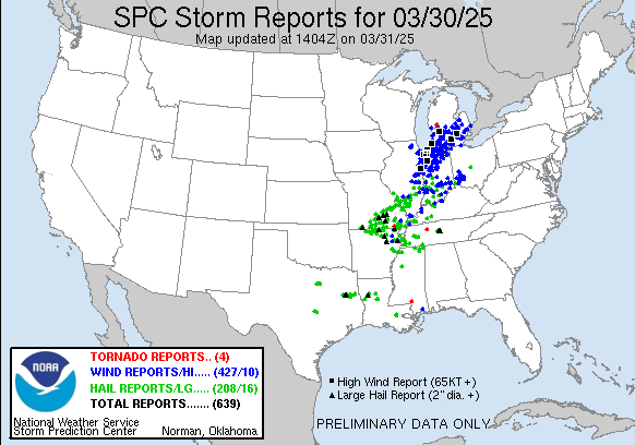
As anticipated, yesterday was a very busy severe weather day with over 600 reports of large hail, damaging winds and tornadoes. An initial line of severe thunderstorms developed over eastern Illinois and moved across Indiana and southern Lower Michigan, producing widespread wind damage – with several significant high wind reports greater than 75 mph – and likely a number of embedded tornadoes. Michigan not only experienced severe thunderstorms but also extreme winter weather, with heavy ice and snow accumulations causing extensive power outages in northern lower Michigan and the Upper Peninsula. All of the weather combined left several hundred thousand customers without power in the state at various times. Check out these pics shared on BlueSky by a fellow meteorologist showing the ice accumulation and damage in Michigan.
A second band of severe storms developed over southeast Missouri and southern Illinois and moved east across the Ohio Valley and eventually into Ohio, with numerous reports of large hail and damaging winds and a few tornadoes. Additional supercell thunderstorms developed southwest of this area and produced numerous reports of large hail – some greater than 2” in diameter – across south central Missouri and northern Arkansas before eventually evolving into a band of severe storms that moved across western and middle Tennessee last night. Finally, supercells developed late at night over the Arklatex and evolved into a band of severe storms that moved across the lower Mississippi Valley and central Gulf Coast region in the predawn hours, producing a 65 mph wind gust at the NWS office in Jackson and a potentially significant tornado in south Mississippi south and southeast of Columbia.
Unfortunately, yesterday was just the start of what is anticipated to be a very busy week of weather with multiple serious weather threats anticipated from severe thunderstorms, heavy rain, fire weather and winter weather.
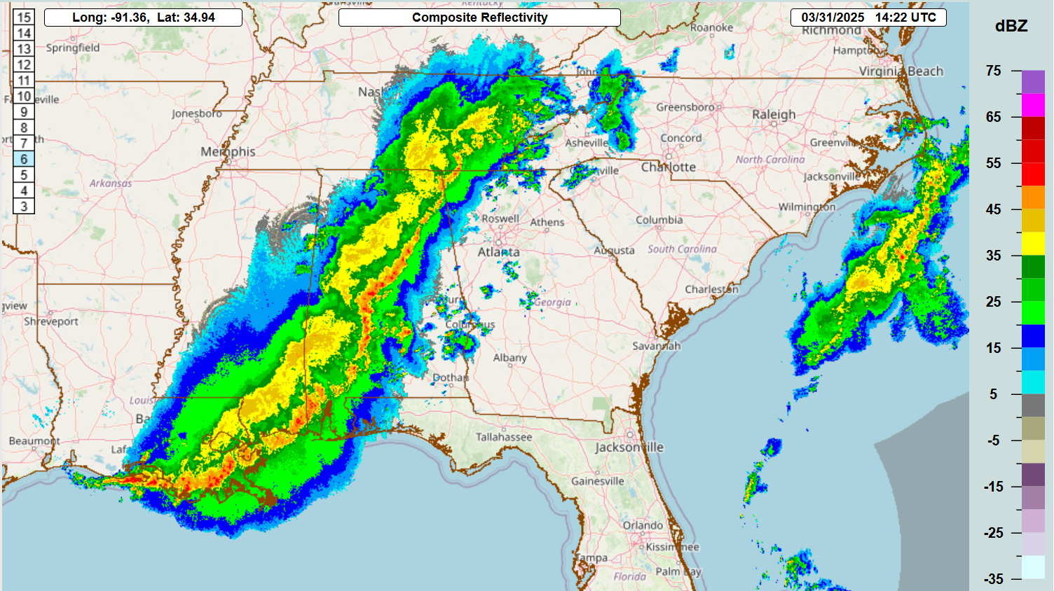

A band of strong to severe storms across the South this morning will continue to move east through the day today, with SPC having an enhanced (level 3 of 5) risk of severe weather ahead of this line, primarily for damaging winds but also for potentially a few tornadoes. Additional severe storms could develop farther north in the mid-Atlantic with again damaging winds the main threat.
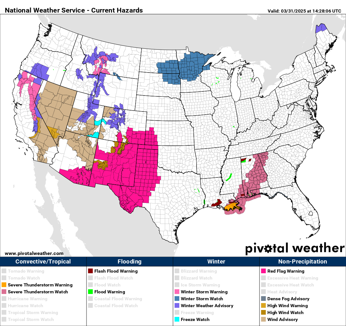

After today’s system exits to the east, attention will quickly turn to the next system moving into the Midwest. This system will produce high winds and mountain snows in the west today as seen in the NWS Hazards map above, and then by Tuesday as the system encounters moisture and instability streaming north, the risk of severe thunderstorms will begin to ramp up. Very large hail and several tornadoes could occur Tuesday afternoon and night across the Plains and mid-Missouri Valley with these storms.

This weather system is expected to intensify further as it swings northeast into the upper Midwest on Wednesday; combined with a large area of very moist and unstable air, this will potentially set the stage for an outbreak of severe storms and tornadoes across a large area from the southern Great Lakes to the Arklatex region. SPC already has this area outlooked in an enhanced (level 3 of 5) risk of severe storms with possible significant severe – EF2+ tornadoes, 2+” hail, 75+ mph winds – highlighted. It seems likely that parts of the enhanced risk area will be put in a moderate (level 4 of 5) risk in future updates. This is definitely a system that has a high ceiling for severe storms, and people in this region need to be monitoring later forecasts.
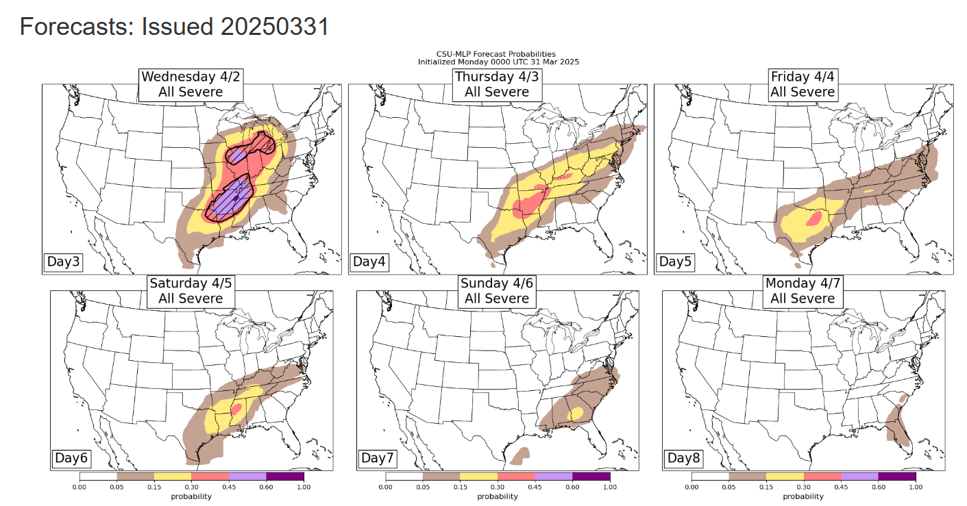
The weather pattern beyond Wednesday looks to remain active for several days as far as severe thunderstorm potential. The Colorado State University machine learning system (CSU-MLP) is highlighting risks for severe weather into the upcoming weekend.
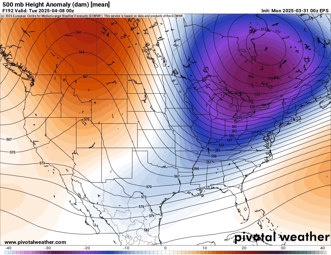
It does look like beyond this weekend a very substantial pattern change is expected next week, with a large trough in middle and upper levels of the atmosphere developing over the eastern United States. This should bring an end to the active severe weather pattern, as well as bringing much colder air to the eastern United States after a week of much above normal warmth this week.
Not just severe thunderstorms this week


This week is not just about the severe thunderstorms, as multiple other hazards are in play. First, there is a substantial risk of river and flash flooding across the middle part of the country. The persistent weather pattern of a large trough in the western US ejecting systems into the middle part of the country will cause multiple waves of thunderstorms in an environment that will be much moister than normal, feeding very heavy rainfall rates. The Weather Prediction center is forecasting a large swath of 5 to 10” of rain this week from the Arklatex right up the Ohio Valley. There will be multiple days of significant flash flood risk that will likely also result in considerable river flooding as seen in the NWS Flood Hazard Outlook.
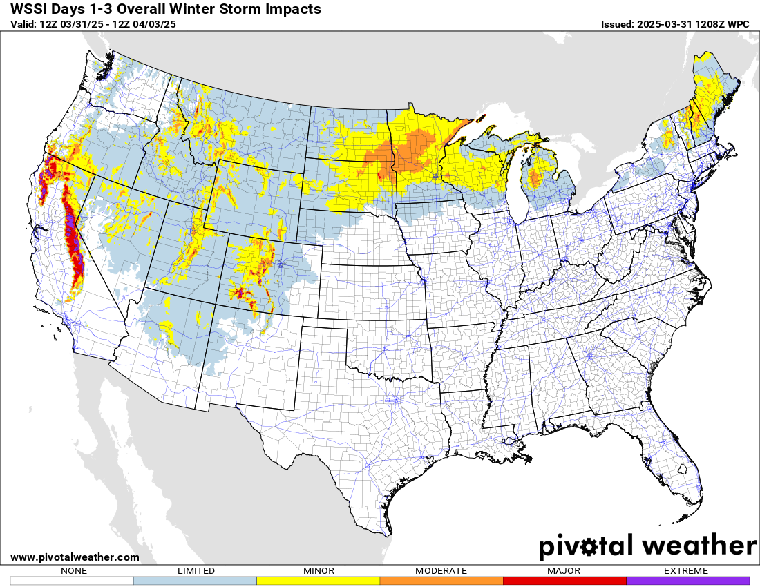
Even though we are getting into April, winter weather is not done yet. After heavy mountain snows in the west today, wintry precipitation with the Tuesday/Wednesday storm system will spread across the upper Midwest and eventually into the Northeast, causing some moderate winter impacts as seen in the Weather Prediction Center Winter Storm Severity Index graphic.
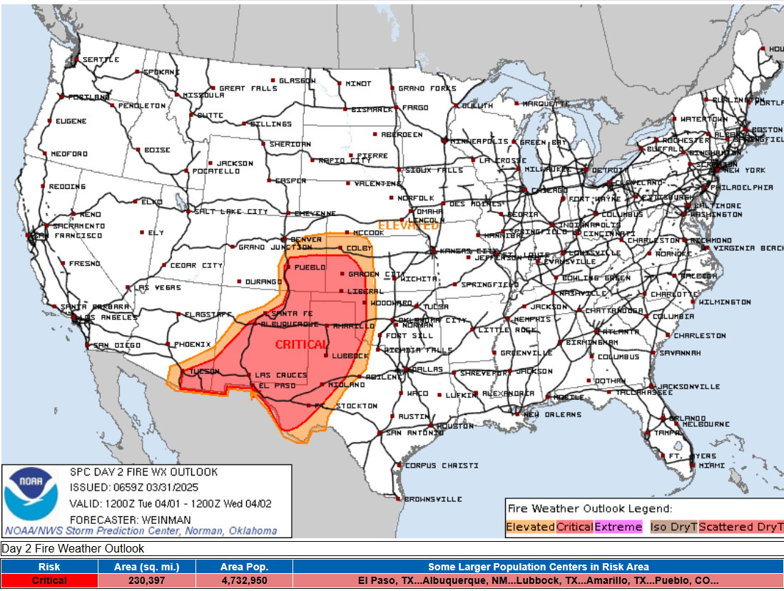
Finally, on the “dry side” of the Tuesday/Wednesday system, concerning fire weather conditions are expected both Tuesday and Wednesday. SPC has outlooked a large region in critical fire danger Tuesday and highlighted potential for rapid wildfire spread; much of the same area will be under the risk of critical fire danger on Wednesday as well.
Programming note: I will be out of pocket traveling today, but hope to post some updates via Substack Notes and Facebook/BlueSky this evening. Given the very busy weather this week, I am planning to provide periodic video briefings and real-time Substack chats starting Tuesday; as I continue to better learn Substack and the subscriber base continues to grow, the briefings and chats will become paid subscriber benefits as outlined here.

Leave a comment