And Thursday overachieved with severe weather in the Southeast
Happy Friday! Lots to talk about as we go into the weekend, so let’s get to it.

Starting off this morning with a recap of yesterday, which definitely overproduced expectations as far as severe weather. Nearly 300 reports of large hail and damaging wind were received from the lower Ohio Valley and Mid-South to Georgia by the Storm Prediction Center. While the coverage of severe weather was much more widespread than anticipated, as we discussed the environment luckily did not support higher end storms as far as an intensity, and only a few hail reports of 2” were received and a couple of brief tornadoes appear to have occurred. Still, tens of thousands of people lost power at the peak of the storms and downed trees injured at least 2 people.


Today should be a quieter day from a severe weather perspective, with just a marginal (level 1 of 5) risk of severe storms from coastal North Carolina to northern Florida. Some heavier rainfall is anticipated in the Mid-Atlantic region as a low pressure system develops today and intensifies a bit off the coast of the Delmarva.

A number of record high temperatures were set in the western United States yesterday, including 100F at Phoenix, 92F at El Paso, and 101F at Yuma. The 100F at Phoenix was the first day with triple digit readings for 2025; while not a record for the earliest date (March 26 1988 holds that honor) it was a full month ahead of the average date. Interestingly, the last time Phoenix had a year with the first date at or above 100F that was later than average was in 2010. Even more record high temperatures are expected today, with triple digit readings common in the deserts of Arizona and southern California again.

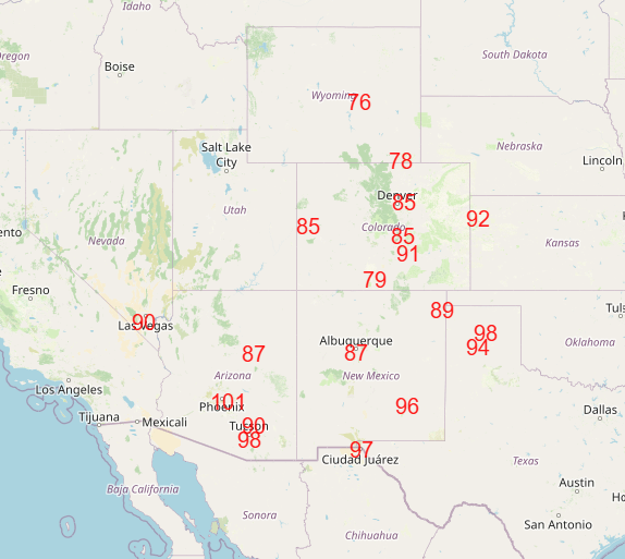
A number of locations should set record high minimums Saturday morning, and during the afternoon the focus for record maximum temperatures will shift a bit east to including the central and southern Rockies and adjoining Plains.
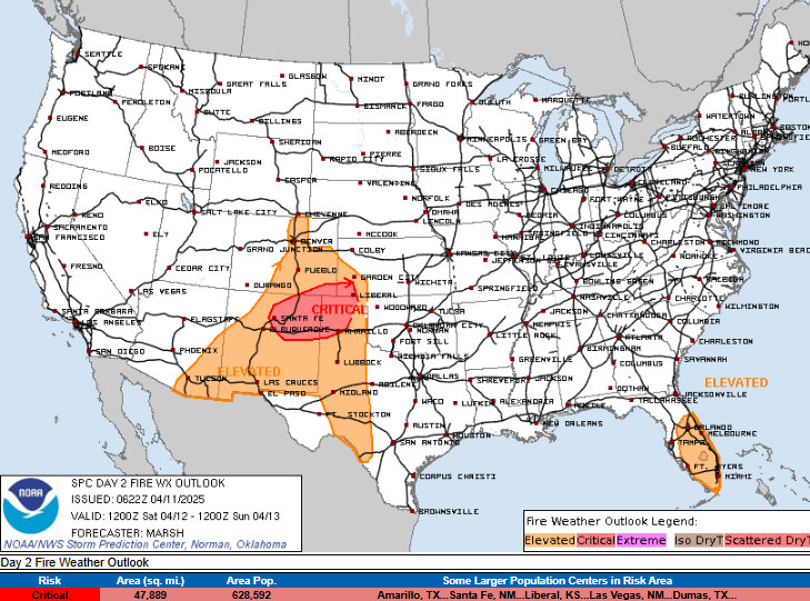

Along with the increasing heat, winds and dry conditions will contribute to increasing fire danger across this region this weekend as well.
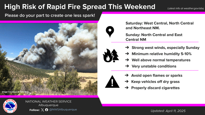
The NWS office in Albuquerque is particularly concerned about the potential for rapid wildfire growth in New Mexico this weekend, especially on Sunday. Much of the Southwestern US is in severe to extreme drought and is particularly vulnerable to wildfire activity as we get into the this period of the year between the winter wet season and the summer monsoon when wildfires are of greater concern.
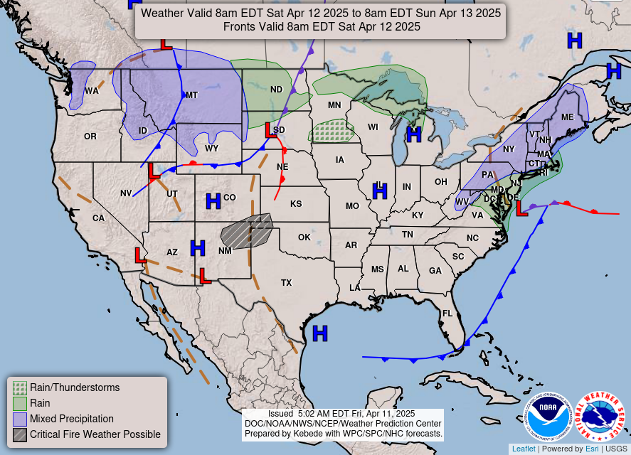
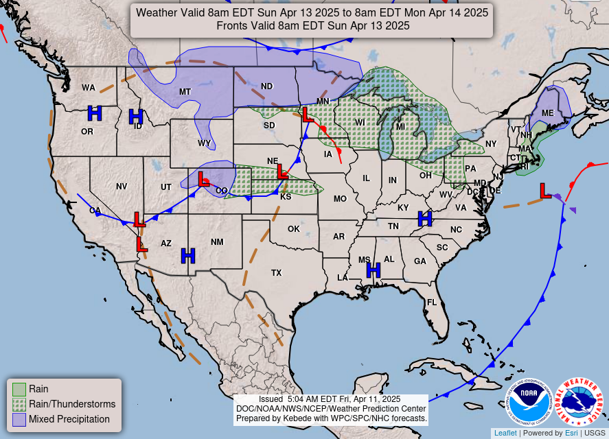
Elsewhere across the country this weekend, the slow moving low pressure system off the Delmarva will bring more wet weather to the Mid-Atlantic and some mixed wintry precipitation to the Northeast. A new upper level weather disturbance developing over the north central states will bring increasing showers and some thunderstorms to the Great Lakes region while some wintry precipitation develops from Montana to northern Minnesota.
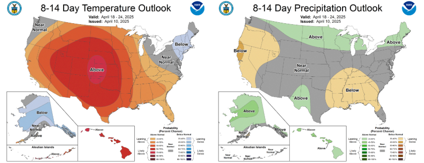
Looking ahead to next week, the same basic weather pattern will persist, with lots of warmth in the western United States but also spreading more into the central part of the country, while the Northeast continues to be under a trough of low pressure with cooler than normal conditions.

Leave a comment