Can we discern how staffing impacted services?
As I discussed in yesterday’s morning newsletter, the sequence of severe weather over the past several days might very well have been the most economically impactful period of what has been an incredibly active year for severe weather. The Friday afternoon St. Louis EF3 tornado alone will likely be a billion dollar event given the intensity and width of the tornado and its path through the heart of a major metropolitan area. Five people lost their lives in this tornado.
Unfortunately, an even more deadly tornado occurred later on Friday evening over southeast Kentucky. Nineteen people were killed as a violent EF4 tornado tore a 55 mile long, at times one mile wide path just before midnight across Russell, Pulaski and Laurel counties, including the cities of Somerset (Pulaski County) and London (Laurel County). Most of the fatalities occurred in Laurel County.
Besides the obvious media attention a tragic disaster such as this usually receives, this event has had additional focus because it occurred in the service area of the National Weather Service office in Jackson, KY, which is one of several offices which have had to suspend 24/7 operations and close part of each day. This resulted in concern that the office was not staffed or at full operational capacity during the severe weather event. The NWS union has stated that the office was staffed and issuing warnings during the event, and a NOAA spokesperson stated (from Lexington Herald Leader article):
The National Weather Service offices in Louisville, Jackson and Paducah provided forecast information, timely warnings and decision support in the days and hours leading up to the severe weather on May 16 As planned in advance, neighboring offices provided staffing support to the office in Jackson, KY. Additionally, the Jackson office remained fully staffed through the duration of the event using surge staffing. Weather forecast offices in the Central Region continue to evaluate storm damage and other impacts from this tragic event.
As I alluded to on social media over the weekend, I had zero doubt that the Jackson office would be staffed sufficiently to at least issue warnings during this event. This event was very well anticipated from a forecast perspective, and I think it is fair to say that a core value that is stressed to every NWS employee from day one is that the issuance of severe weather warnings is the absolute, number one priority of every NWS field office. This was certainly drilled into me when I started in the NWS in 1990, and I still vividly remember an event early in my career when severe weather developed unexpectedly on a Friday evening when I was the only person on shift. Being a Friday, I could not get a hold of anyone else (we only had 6 operational staff members at our small NWS office) and I was forced to only do severe weather warnings and weather observations for the bulk of the shift. I can still remember running into our old dark radar room to interrogate storms using our 1974 vintage conventional radar, then running to the PC where we used a program called SRWARN to issue the warnings, then running into the NOAA Weather Radio room to record and broadcast the warning, and then repeating that process over and over again for hours, with my only break being to run outside and take a weather observation.
This is the kind of dedication to mission and service that NWS staff still has to this day, so again, I was confident the Jackson office would be staffed to issue warnings. As a longtime meteorologist-in-charge (MIC), what concerned me was not if the office would be staffed to at least be able to issue warnings, it was other related issues that could have a significant impact on operations as I discussed briefly in a post over the weekend. To recap what I said there:
I would be concerned about how chronic understaffing might be worsening the fatigue and stress that an NWS office staff deals with after a major fatality weather event, and also about the capacity for the staff to be able to conduct the extensive damage assessments needed after an event of this magnitude. Looking at operations during the event, while warning services were unlikely negatively impacted, I would want to know if the staff was able to perform decision services they ordinarily do during events of this magnitude like emergency management briefings, information sharing with core partners using the NWSChat software, etc? Furthermore, will the office even be able to conduct a full post-event evaluation of operations and services to identify any potential shortfalls such as this and determine potential improvements?
I had a chance over the last day or so to look at more detail at the warnings and radar data from the Jackson area Friday night, as well as some of the media coverage, and feel like I can share some (hopefully) educated perspective on the questions above. I want to stress that I do not have any insider information, what I am sharing below is my perspective based on my experience as an NWS meteorologist-in-charge and looking at the publicly available data and media reports.
My first question above related to the potential fatigue and stress on the staff from chronic understaffing, and I have to say that both the media statements from the NWS union and the NOAA spokesperson quoted above only reinforce my fear that this is potentially a significant issue for the staff in Jackson. Per USA Today, the union stated that the severe weather staffing was covered by “a few individuals agree(ing) to work double shifts to make sure timely warnings continued into the overnight hours.”
As my recently retired MIC colleague Rich Okulski notes in his BlueSky post, a typical moderate to high risk severe weather day would likely involve at least eight employees – that does not seem to have been what was in place here at least based on the comments from the NWS union. I know from personal experience that working severe weather is tiring and stressful; doing it as part of a 16 hour day is even more tiring and more stressful, and dealing with high end severe weather where you know major damage and/or casualties are occurring and with a bare minimum amount of staffing takes it all to another level.
Furthermore, this was not a one time situation. As an MIC, I certainly dealt with periods where the staffing of our office was suboptimal for any of a number of reasons: staff departures, people being sick, holiday periods, etc. These were short term issues though that I could typically manage – and even then, there were occasionally unavoidable situations where myself and other staff members had to work through less than ideal situations to meet the mission during severe weather situations. Looking at the situation the Jackson office is facing, just in the month of May – the period when the staffing would have reached its current low point due to the federal employee buyouts – the office has issued 121 severe thunderstorm, tornado and flash flood warnings. Seven of the first 17 days of the month had warnings of some type needed. Combine that with the normal type of situations that routinely arise in an office that need to be covered such as sick and emergency leave, and it seems quite likely that the office staff was already dealing with a lot of extra overtime work going into this event. While the NWS is trying to use reassignments to help augment staff shortages like the ones at Jackson, this will not be improving the situation in the immediate future, so the staff is having to deal with the additional stress of knowing this staffing shortfall is an issue they will be dealing with for some time.
The NOAA spokesperson stated that “as planned in advance, neighboring offices provided staffing support to the office in Jackson, KY.” This is in my opinion an admission that the office cannot currently provide its typical level of service without assistance from other offices. While again this sort of intraoffice mutual aid is something the NWS has occasionally had to do in the past, it is not meant to be standard operating procedure across numerous offices (or the entire agency) for an indefinite period of time. There is no way that this sort of operational posture can continue for an ongoing period without degradation of service.
Furthermore, the unfortunate reality is that there are in fact indications of inadequate – or at least less than optimal – service from this event if you dig deeper than just the question of “did the warnings go out ahead of time?” For example, in my concerns above, I noted the ability of the office to conduct the necessary post-event damage assessments. The office was in fact able to complete the basic damage survey for the main killer violent tornado, with assistance from the Nashville and Louisville offices (assistance which is not unusual for a tornado event of this magnitude). However, when you go the NWS Jackson webpage, you will find no detailed information about this tornado anywhere on the site – despite the fact that the office itself stated in their survey report that this tornado was “one of the strongest tornadoes and also the deadliest to ever impact the Jackson NWS coverage area.” It also stands in stark contrast to other offices impacted by severe weather on this day; the St. Louis, Paducah and Indianapolis offices each have webpages dedicated to this weather event with extensive meteorological data and damage information. These kind of event summary webpages are very useful to the media, emergency management, and the general public. While there could be other reasons in play, it is hard to imagine that staffing issues are not playing a role here in this sort of information not being provided on the Jackson website.
Additionally, when you do the kind of deep dive into the actual warning services that I suggest above should be standard operating procedure for any NWS office after an event of this magnitude, you see issues which could certainly result from insufficient staffing. For example, the initial warning for this tornado was issued at 10:29 pm ET for Pulaski and Wayne counties. It was issued as a “base” tornado warning with no “tags,” i.e., it was a standard tornado warning for a radar detected possible tornado.

By 10:40 pm, the radar data from the Jackson radar shows that the tornadic circulation has entered Pulaski County and there is a clear indication of a tornadic debris signature in dual polarization radar data. This is seen in the minimum of correlation coefficient values shown in blue on the lower right hand image, which tells us that the radar is detecting lofted debris from a tornado.

A couple of minutes later, there is a clear sign of tornadic debris at higher level elevations of the radar data, showing that debris extends up to at least 15,000 feet in the storm, indicative of a strong tornado.
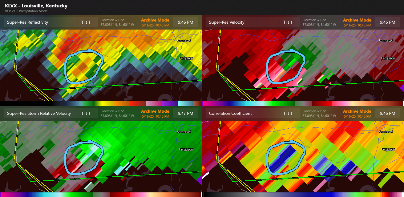
The tornadic debris signature is also clearly visible by 10:46 pm ET on the Louisville radar, with strong values of rotation being detected by both the Louisville and Jackson radars. All of these are rather clear indications of a confirmed tornado in progress, and one that is likely intense. However, the Jackson office did not issue any severe weather statements – the statement that offices issue to update an ongoing warning – for this warning until 10:56 pm ET, and even then that warning did not mention a confirmed tornado.
At 10:57 pm ET a new tornado warning was issued that did have a “confirmed tornado” tag. This warning had an identical polygon to the severe weather statement that was issued at 10:56 pm ET, so I am assuming a new warning was issued with the confirmed tag to get broader distribution of the confirmed wording. Even though radar data continued to suggest that this was a potentially strong to intense tornado, the “particularly dangerous situation” tag was not used until another new tornado warning was issued at 11:07 pm ET (at which point there were briefly 3 separate tornado warning polygons in effect for Pulaski county). This warning also added downstream locations to the warning, including London.
The bottom line from what I can ascertain is that for the basic question of “were warnings issued with sufficient lead time,” as noted by my colleague Ray Wolf in his BlueSky post, the answer is yes. However, when you look in detail at the data and the individual warnings and statements, it seems clear that more information about the tornado being confirmed by radar and its potential intensity could have been shared. Insufficient staffing certainly could have played a role in how much time the staff had for radar data interrogation and/or product generation.
I have seen some comments on social media implying that the fact this updated information was not provided is not that big of a deal – but I do not share that perspective. First, there is empirical evidence that suggests that whether or not a tornado is confirmed does affect people’s response to a warning and whether or not they take protective action. While it is not explicitly stated in NWS Directives, I feel it should be a best practice that warnings be updated with a severe weather statement as soon as there is sufficient evidence for tornado to be confirmed. Secondly, while there are mixed social science research results on whether or not the “particularly dangerous situation” (PDS) type impact based warning significantly improves warning response, the fact is that NWS Directives currently dictate offices should provide this information if warranted, and if it is not provided when the indicators are there it can cause confusion.
There is in fact evidence that there was confusion during this situation. My colleague Matt Lanza wrote a provocative Substack piece earlier this week about online streaming severe weather sites and how they provided information during this severe weather outbreak. If you watch Ryan Hall’s streaming coverage during the time the storm is moving through Pulaski County and approaching Somerset, in my opinion you can see that he is confused by the lack of an update from the NWS either to confirm the tornado or to include “particularly dangerous situation” wording. While it is certainly possible that the office was providing core partners such additional information via NWSChat (the messaging system NWS uses for real-time collaboration with core partners), the general public did not receive any update about the nature of the tornado between the initial radar-based issuance at 10:29 pm and the new warning at 10:57 pm stating the tornado was confirmed by weather spotters.
I believe deep in my core that the NWS must be the source of the most accurate, up to date information about severe weather threats if we want to ensure that every person – including the most vulnerable members of our society – has access to the most up to date severe weather information when they need it. Unfortunately, it seems likely that people relying on the NWS in this time period were not receiving as up to date information as those following other sources; while there is no way to be certain it was due to staffing issues, it seems likely that it was at least a contributing factor. I should note that after the 11:07 pm tornado warning with the confirmed and PDS tags, more frequent updates that included both of those tags were issued by the office as the tornado crossed Laurel County and the London vicinity.
In summary, it seems to me that there are several pieces of evidence from this most recent tornado event that suggest that services are being impacted negatively by the current staffing situation and related issues facing NOAA. I want to conclude this post, though, by going beyond the near term implications. There are transformational advances with severe weather warning and forecast information being made right now across the weather enterprise using artificial intelligence, improved numerical modeling and data fusion techniques. Additionally, important social science research is helping us better understand how people use warning and forecast information and what their needs are. For example, you can go to the NSSL Tornado Tales webpage and use your own experience with tornadoes to participate in research that will help social scientists answer questions like “does knowing a tornado is particularly strong make people take a warning more seriously?”
We are on the threshold of being able to implement physical and social science research advances that will help make tragedies like Friday’s severe weather less deadly. In spite of the staffing and budget challenges facing NOAA currently, what needs to be happening right now in the weather and emergency management communities is a conversation on what information does the public need to make the best protective decisions for hazardous weather and how do we optimally staff, organize and support NOAA (National Weather Service and NOAA Research) to develop and provide that information. I hope that in spite of everything we are dealing with right now, we can have that conversation and eventually move forward with improvements and avoid taking steps in the wrong direction.

Leave a comment