3 killed by a tornado in upstate NY, at least 6 killed in boating incident on Lake Tahoe
Two weather events caused tragic loss of life over the weekend. The first was on Lake Tahoe, when about 3 pm PT on Saturday a boat with 10 occupants capsized with all of the occupants ending up in the water. 6 of the people tragically died, 2 are still missing, and 2 were rescued and treated for hypothermia.
We have been talking the last couple of days about the unusual upper level trough of low pressure over the western United States, and in this radar loop of reflectivity (left) and base velocity (i.e., wind, right) from the Reno, NV NWS Doppler radar, you can see a band of showers and thunderstorms associated with that weather system dropping southeast across the region including Lake Tahoe (the lake is in the center of the image in a lighter gray color, the community of South Lake Tahoe can be seen on the map at the south end of the lake). It appears that a boundary associated with the showers and storms progresses south across the lake, as winds switch from inbound (green) to outbound (red) as the boundary moves south.

If we look at the weather observations from an observation site in the middle of the lake, you can that while winds were increasing ahead of the showers and storms, they dramatically increase at 3 pm as the small weather system moves across, with sustained winds of 29 mph on the 3 pm observation and gusts of 45 mph on both the 3 and 4 pm observations.
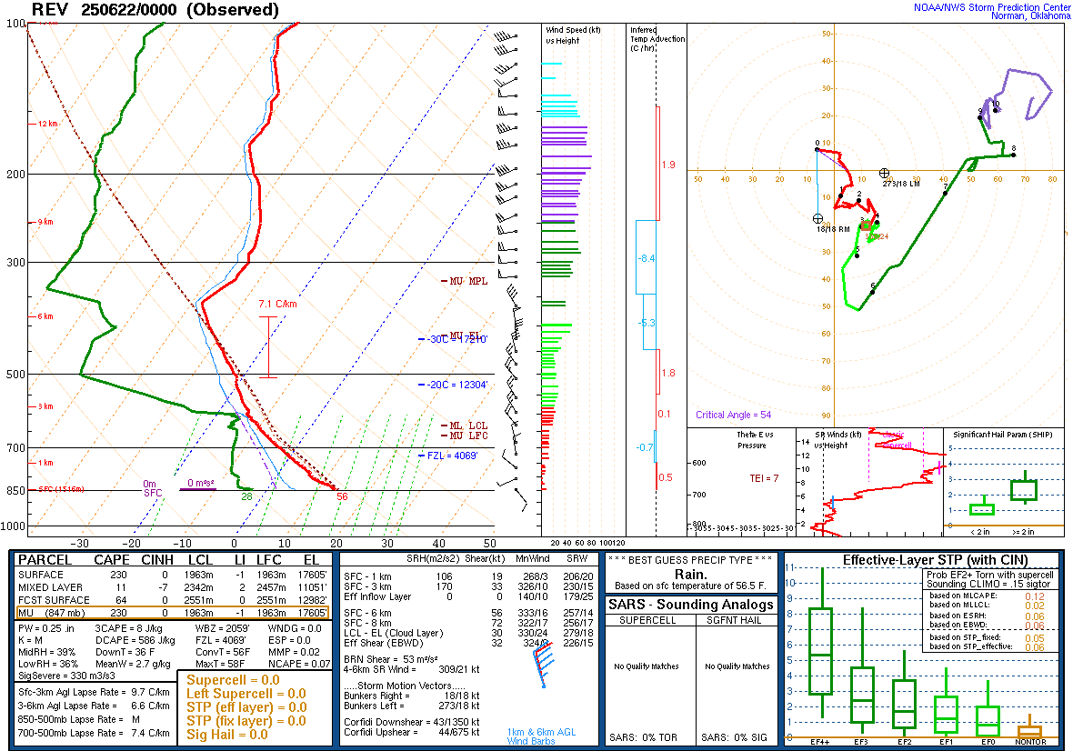
The NWS upper air balloon release from Reno was taken shortly after this tragic event, and it showed a pretty classic inverted-V pattern indicative of the potential for microbursts as precipitation falling from high based convection evaporates (or sublimates if solid precipitation) in the dry air near the surface. This likely led to microbursts that produced localized even stronger wind gusts on the lake. (You can go to my post from April to read more about inverted-V soundings and microbursts.) This idea is further supported by the rapid fall in temperature (far left column of data) and increase in dewpoint (second column from left) showing that strong evaporational cooling was taking place.
This event is a sobering reminder of how localized high impact thunderstorm events can happen anywhere in the country – and of the importance of wearing life jackets when on a boat, weather can change dramatically in a short period of time and leave you in the water.
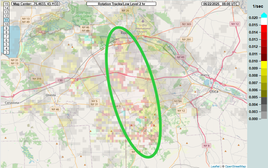
Another tragic event occurred early on Sunday morning, as a line of severe storms came south out of Canada into upstate New York. The MRMS rotation tracks product from the time shows evidence of a “mesovortex” – a small area of low pressure within the line of storms – moving south within the complex of storms. Mesovortices can produce tornadoes, and in this case did produce an EF1 tornado near the small community of Clark Mills, west of Utica.

Falling trees present a particular danger in the eastern United States, and in this situation trees fell and sliced through two separate houses, tragically killing two children in one of the homes and another person in the second home.
The focus the next few days will be on the deadliest weather hazard the United States harbors – heat. Over the weekend, the heat wave kicked into high gear across the Midwest. On Sunday, dozens of record warm temperatures – both maximums and minimums – were set across the region. Once again, record warm minimums were particularly prevalent and impressive: Milwaukee a low of 78F, breaking their daily record by 5 degrees; Chicago a low of 80F breaking their daily record by 4 degrees; and Minneapolis with a low of 82F, shattering their daily record by 7 degrees, setting a record for warmest minimum temperature so early in the season, and tying for the 4th warmest record warm minimum on record (records date back to 1872 in Minneapolis).
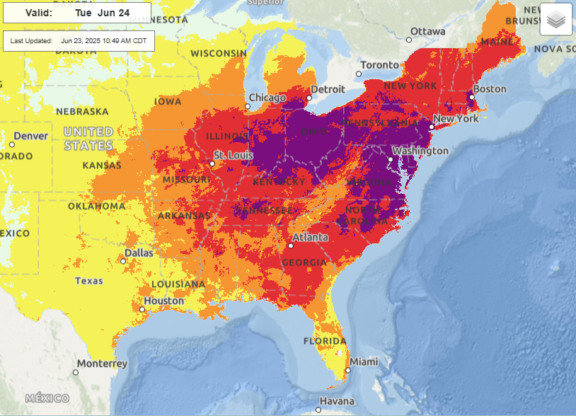
It still looks as if Tuesday will be the peak of the heat wave, with dozens of record warm temperatures excepted from the Midwest to the East Coast combining with oppressive humidity – widespread dewpoints in the 70s – to result in a huge expanse of major to extreme heat risk across the the eastern half of the country.
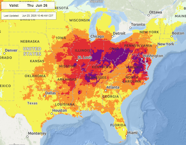
While the intense upper level area of high pressure will begin to slowly weaken after Tuesday, allowing some cooler air to move into parts of the Great Lakes and Northeast, the core of the heat from the the mid-Mississippi and Ohio Valleys east and southeast into the Mid-Atlantic and Southeast will continue through much of the work week, resulting an unusually prolonged and intense heat wave for this region.
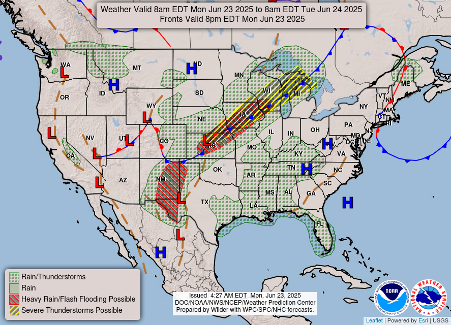
While the heat wave will be the weather event impacting the most people over the next several days, there will be other weather concerns as well. Today thunderstorms will be a concern along the slow moving cold front from the Great Lakes to the central Plains. Severe storms with damaging winds and some large hail are possible, and SPC has a slight (level 2 of 5) risk in this region. Unusually high levels of moisture will also fuel high rainfall rates and increased flash flooding risks, and a slight (level 2 of 4) risk of excessive rainfall is in place for much of the same area.
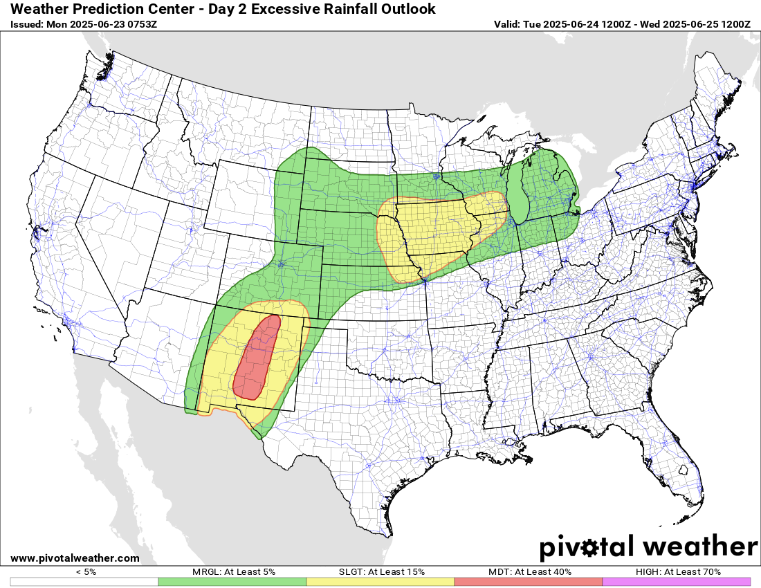
The concern for flash flooding will be even greater in New Mexico, where unusually high levels of monsoonal moisture interacting with the mountainous terrain will result in thunderstorms with high rainfall rates the next several days, potentially producing major localized flash flooding, particularly in the vicinity of wildfire burn scars. WPC has a moderate (level 3 of 4) risk of flash flooding for Tuesday when the peak in flash flooding risk is anticipated – but concerns for flash flooding will exist over New Mexico much of this week.
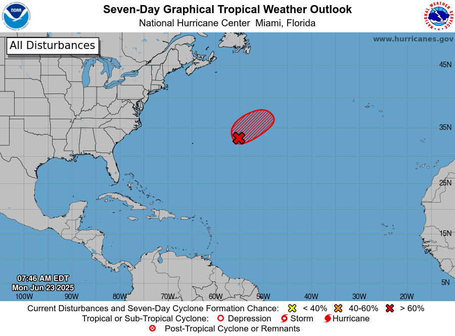
Meanwhile, in the tropics, an area of low pressure has developed east of Bermuda in a region that is marginally supportive of tropical development in the near term.
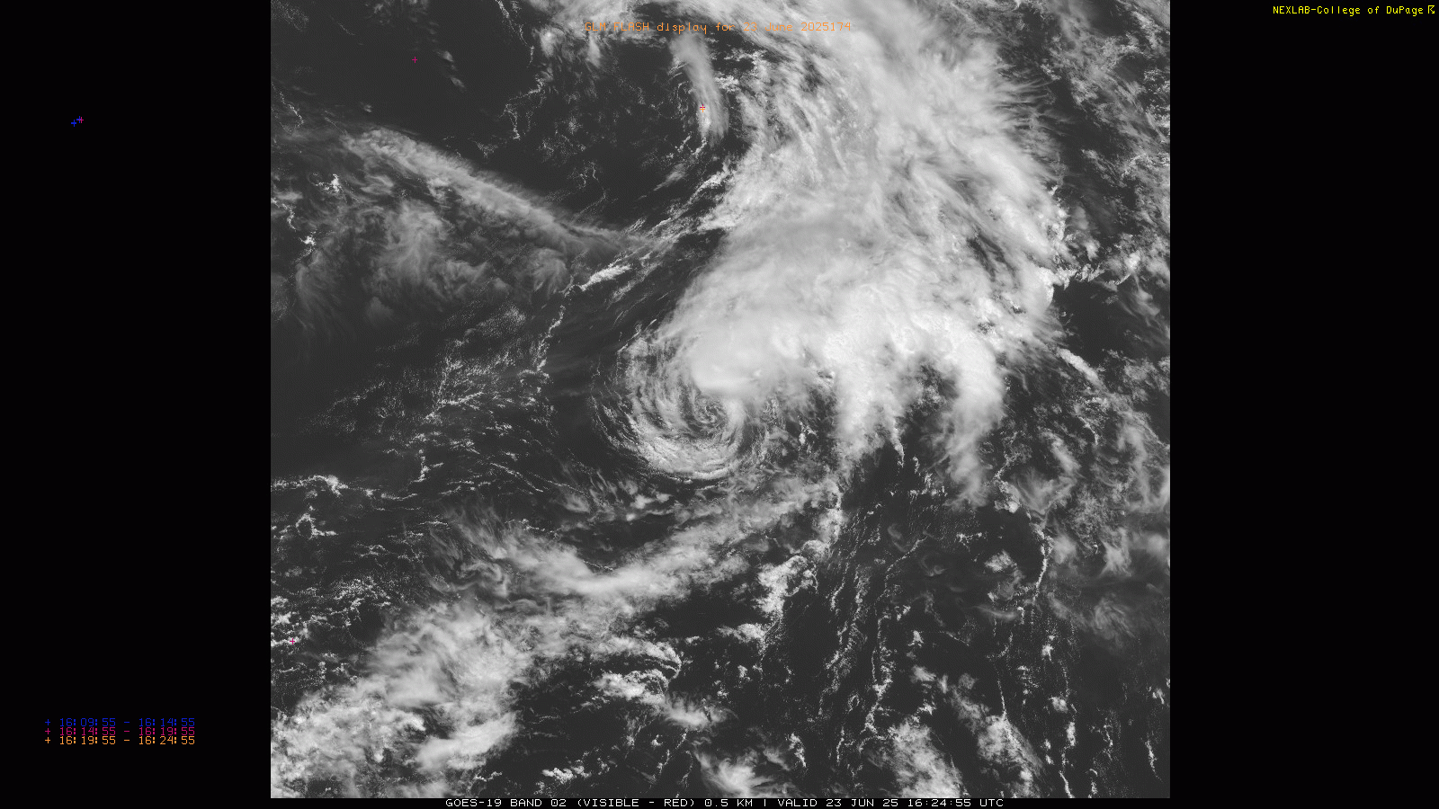
While NHC has increased the potential for tropical cyclone formation to 70%, morning satellite data shows that the thunderstorms associated with the low are mainly well to the northeast of the center and that the circulation center is exposed. These trends are not indicative of increasing organization currently. Still, it does have a short window of time where it could become better organized before it moves into increasingly unfavorable conditions on Tuesday. Even if it does become a tropical cyclone, it should remain weak and move northeast over the open waters of the Atlantic. I will have my full weekly tropical update later today or Tuesday morning.

Leave a comment