3 killed in Ruidoso, NM; major urban flash flooding in Chicago
Another day and a couple of more serious flash flood events driven by localized heavy rainfall. The most impactful was in Ruidoso, NM, which has been plagued by frequent flash flood events since the South Fork wildfire west of Ruidoso about a year ago. The wildfire created a burn scar in the headwaters of the Rio Ruidoso, a river that runs through the town. When heavy rain falls on top of this burn scar, the burned out area absorbs very little of the rainfall, and as the water rapidly runs off into the river it creates a debris flow flash flood which moves down the river channel.
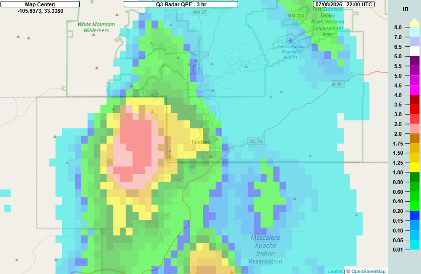
Thunderstorms in the Southwest grow increasingly common through the summer due to the monsoon, which brings moisture into the region from the south and southeast and allows thunderstorms to form on higher terrain during the day. Monsoon thunderstorms are common in the region around Ruidoso, and yesterday a couple of slow moving thunderstorms focused on the burn scar region west of Ruidoso, producing 2-3” of rain in less than 3 hours.

As I have discussed before, NWS forecasters use the Multi-radar Multi-Sensor system (MRMS) FLASH products in their flash flood warning operations. The primary tool is the unit streamflow product, which runs MRMS rainfall estimates through a hydrologic model that can produce estimated runoff and inundation, giving forecasters an estimate of the likelihood and magnitude of flash flooding. For burn scar situations, FLASH has a special version of the unit streamflow called “hydrophobic,” which assumes that all of the rain immediately goes into runoff with no absorption. In normal situations this is meant to give the forecaster a worst case scenario, but in burn scars where very little absorption by the ground occurs, it is generally quite realistic. Here the product shows extreme values, in spots maxed out, showing the potential for catastrophic flash flooding.

Unfortunately, the projected flash flooding occurred, with a major debris flow floodwave moving through Ruidoso. This river gage east of town showed the wave as it passed through, with the river rising about 20 feet in less than an hour.
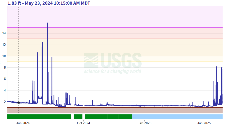
While that plot shows that the record for Rio Ruidoso was 12.1’, in fact in the last year since the South Fork fire, multiple debris flow flash floods have come through the river channel, and the 12.1’ record was exceeded twice in the summer of 2024, including a crest near 16’. However, yesterday’s flood exceeded that new record by about 4’. Unfortunately, 3 people have been confirmed killed in this flash flood with significant damage reported.

Meanwhile, another slow moving area of thunderstorms over the wrong place produced a small area of 3-6” of rainfall in less than 3 hours right over central Chicago.

The MRMS FLASH unit streamflow product (not hydrophobic, just “normal”) showed again extensive runoff and inundation with values greater than the maximum of 20. Again, rainfall rate is a huge contributor to this impactful flash flooding, particularly in urban areas as the intense rainfall overwhelms systems designed to help drain storm water. This article from NBC5 in Chicago indicates that an NWS gage just west of the United Center in Chicago reported 5.12” of rain in 90 minutes, a just crazy rainfall rate in an urban area. This resulted in major flooding of roadways and underpasses leading to numerous water rescues as well as flooded buildings and basements, but luckily as of now, no fatalities appear to have occurred.
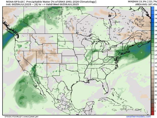
Both of these serious flash flood events demonstrate how flash flooding can primarily be driven by the development and evolution of thunderstorms at a local scale that is very difficult to forecast ahead of time. Neither of these flash floods occurred in areas with particularly obvious enhanced risks of flash flooding. The map above is the analysis of precipitable water from last night compared to normal, and as you can see much of the United States has above normal moisture, with a particular band of enhanced above normal moisture in the Chicago area. On a very basic level, the higher the moisture, the higher the rainfall rates from thunderstorms, and if small scale processes cause the storms to stall out over a very vulnerable area, you can get disastrous results in a very short period of time.
It is important to recognize that numerous studies have shown that climate change is resulting in higher moisture content in the atmosphere supporting higher rainfall rates; warmer air can hold more moisture, and higher sea surface temperatures, as we have seen this year in the Gulf and Caribbean, provide more water vapor to the atmosphere.

Turning to today’s weather, once again flash flooding is going to be a primary concern. As you can see in the above precipitable water map from last evening, abnormally high moisture remains over the eastern United States, partially due to remnant moisture from Tropical Storm Chantal. An upper level system and associated cold front moving into the area will drive thunderstorm activity this afternoon and evening in this very moist environment.

Rainfall guidance from the High Resolution Ensemble Forecast (HREF) system suggests bands of 4-7” of rainfall from some of these thunderstorms, which given recent very wet weather could result in significant flash flooding. The Weather Prediction Center has placed a moderate (level 3 of 4) risk for much of the Mid-Atlantic.
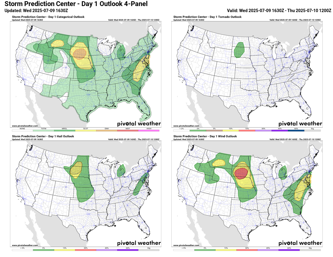
Severe weather will also be a risk with the thunderstorm activity in the east, and SPC has a slight (level 2 of 5) risk of severe storms with damaging winds the primary risk. Meanwhile, the central and northern High Plains are looking at another active severe weather day, with supercell storms expected to develop this afternoon in the western Dakotas with a risk of very large hail and a few tornadoes. This activity should develop into a complex of severe storms with significant wind damage potential as it moves east. An enhanced (level 3 of 5) risk of severe storms is in place here.

Farther west, heat and fire danger will be a serious concern with dry conditions and increasing temperatures. Desert regions of the Southwest will see temperatures greater than 115F and extreme heat warnings are in effect. Red flag warnings are in place for many other locations in the West and wildfires continue to become an increasing concern in this region.

Leave a comment