This time it’s Milwaukee hit with record flooding
Aug 10, 2025
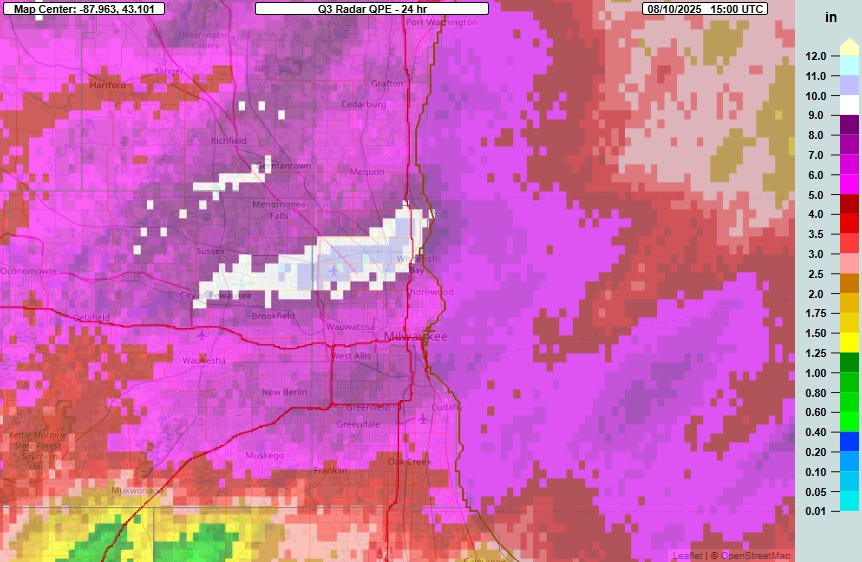
Well, we talked in yesterday’s newsletter about the risk for significant flash flooding returning to the Midwest this weekend — and the atmosphere delivered overnight. Late last evening, thunderstorms developed over the southeast Wisconsin, and storms with radar derived instantaneous rainfall rates of up 7” per hour trained across the region including the Milwaukee metro area. While the most widespread and intense activity occurred between about 8 pm and 2 am, additional thunderstorms have been scattered across the area through the morning. Five inch rainfall totals have been widespread across the entire region, with several bands of 6-10”. The heaviest rain looks to have fallen in the northern Milwaukee metro area where the Multi-radar Multi-sensor system shows a band of 9-12” from Pewaukee to Whitefish Bay.
Within that band, the Wisconsin Mesonet noted on BlueSky that a rain gauge at Madison High School reported a 24-hour rainfall of 14.23” which if verified would be a state of Wisconsin record. To me, the amount seems at least a little suspicious given the radar estimates and surrounding totals, but regardless, tremendous rainfall has occurred with several locations over 10” and approaching the state 24-hour record of 11.72”.
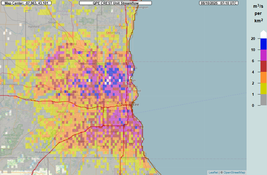
As we have seen numerous times this summer, urban areas are not built to handle this kind of rainfall, and the MRMS FLASH hydrologic product showed the result with widespread areas of unit streamflow greater than 10, indicative of major flash flooding.
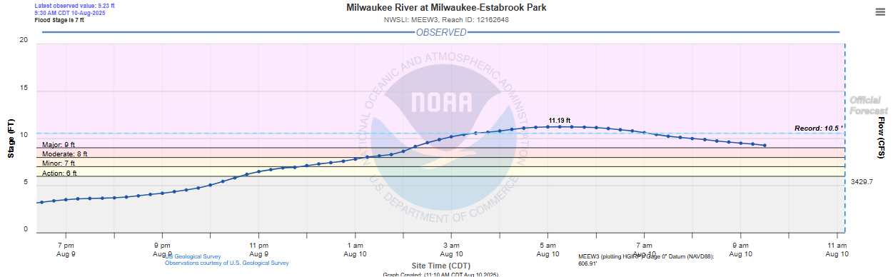
The streamflow gauge on the Milwaukee River at Estabrook Park north of downtown crested at 11.19’, setting a new record. Records on this gauge go back to at least 1940, so this is truly a historic flood event. There have been major impacts in the metro area, with numerous buildings and residences flooded, water rescues, and the final day of the Wisconsin State Fair canceled after flood waters impacted the venue last night. This webpage from the Milwaukee Journal Sentinel is tracking all of the impacts and has some remarkable videos of flooding.
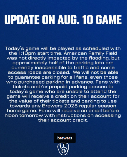
As an aside, while I was writing this post, the Milwaukee Brewers MLB team announced that today’s 1:10 pm game will go an as scheduled despite half of their stadium’s parking lots being inaccessible due to the lots themselves being flooded or flooded access roads. I have to say that from an emergency management perspective I am confused by this decision. Even though they are giving people an out by offering refunds, the team is potentially worsening an already dangerous situation by bringing people into an area that is impacted by flooding, as well as (I assume) requiring employees to get to the stadium in a potentially difficult travel environment. Obviously, I hope that moving forward with the game works out safely for all involved but in my opinion, this is a decision indicative of how we as a society do not take flash flooding as seriously as other hazards, which contributes to it continuing to be one of the leading weather related causes of death in this country.

While at least one more band of rain and storms will be shifting through southeast Wisconsin over the next couple of hours, it appears as though the main risk for additional significant flash flooding later today will be focusing farther southwest along the slow moving Midwest cold front, with a moderate risk (level 3 of 4) of flash flooding in southern Kansas and southwest Missouri and a large surrounding slight risk. A slight risk of flash flooding also continues along coastal South Carolina and Georgia where a wet and stormy weather pattern continues.
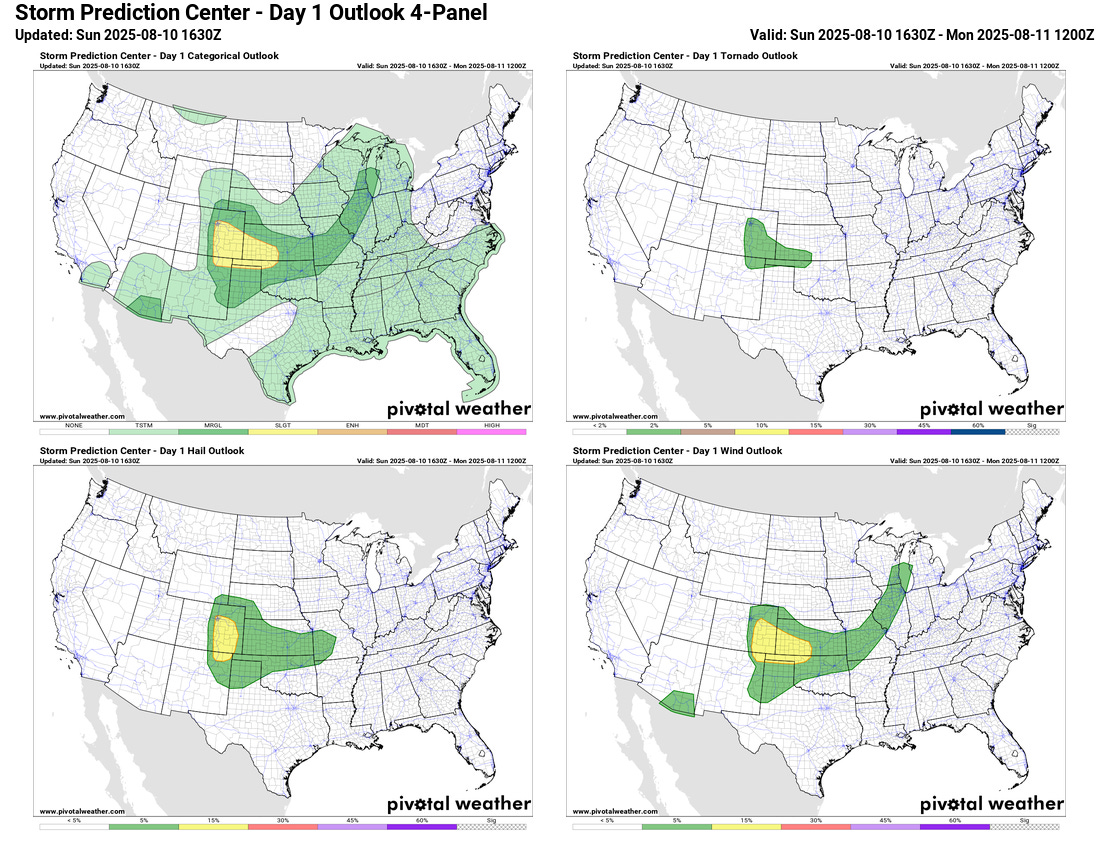
The primary risk of severe storms today looks as if it will be focused even farther west, in the High Plains of eastern Colorado, western Kansas and the Oklahoma Panhandle.
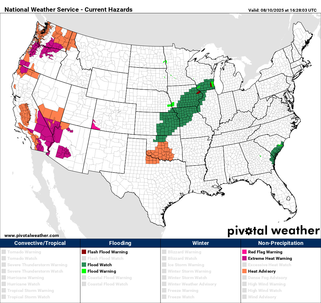
In the West, heat will be the primary weather risk with extreme heat warnings and heat advisories in effect for many areas. Fire danger will be a bit less across the region today due to lighter winds, but hot and dry conditions will continue into the upcoming week and stronger winds may develop in parts of the Pacific Northwest and Great Basin later this week.
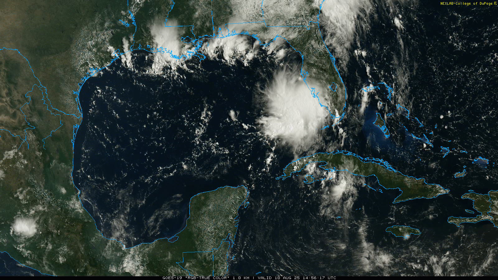
Turning to the tropics, a rather concentrated area of thunderstorms has developed this morning over the southeast Gulf within the area of disturbed weather we have been talking about near Florida. While no models are showing anything more than a very weak area of low pressure developing with this system, it is over very warm water in an area of relatively weak upper level wind shear, so it is worth keeping an eye on as it moves northwest the next couple of days.
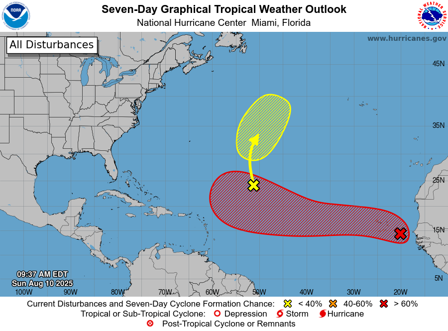
Way farther east, the tropical wave off of the west coast of Africa has become better organized over the last 24 hours and has been officially designated an “invest” area (97L) by NHC. It is expected to bring heavy rain and gusty winds to the Cabo Verde Islands the next 24 hours and NHC has a 40% probability of development into a cyclone in the next 2 days. Beyond this time, it has an 80% probability of development as it moves west-northwest across the Atlantic. Most of the models continue to develop this into an organized system this week by the time it reaches the western Atlantic. As of now it appears most likely this system will remain north of the Lesser Antilles, and we will have plenty of time to watch how things evolve for any downstream threat farther west.

In the Pacific, Henriette is intensifying rather quickly well northeast of Hawaii, and is expected to become a hurricane in the next 24 hours as it continues its rather unusual path northwest across the central Pacific.

Leave a comment