Still unlikely to be a US threat; 98L runs out of time and water for development
Aug 15, 2025
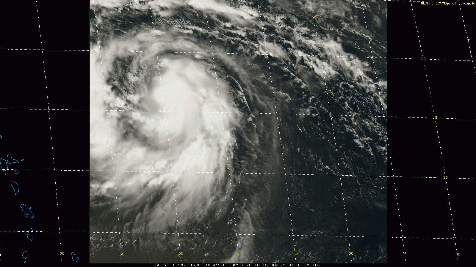
Starting off this morning in the tropics, where Erin has become the first Atlantic hurricane of the season east of the northernmost islands of the northeast Caribbean. NOAA and US Air Force reconnaissance aircraft have been in the storm much of the last 18 hours, and based on that information and satellite, Erin is definitely not rapidly intensifying yet. However, it is showing signs of better organization, especially in the last few hours, with slowly decreasing atmospheric pressure in the storm’s center and sufficiently strong winds to make it a minimal hurricane with 75 mph winds.
As we have been talking about for a few days now, Erin will be moving into an increasingly favorable environment for intensification as we head into the weekend, with increasing atmospheric moisture and sea surface temperatures and relatively low wind shear for the most part. NHC model guidance that provides probabilities of rapid intensification (RI) — defined as an increase of maximum sustained winds of at least 30 knots in 24 hours — show much higher RI probability values than normal. As a result of all of this, Erin is forecast to intensify into a major hurricane this weekend and could become a category 4 hurricane by early next week.
![[Image of rainfall potential]](https://substackcdn.com/image/fetch/$s_!YK8B!,f_auto,q_auto:good,fl_progressive:steep/https%3A%2F%2Fsubstack-post-media.s3.amazonaws.com%2Fpublic%2Fimages%2F807b4d37-cdbf-4c7a-bd56-fd54f556e047_3300x2550.gif "[Image of rainfall potential]")
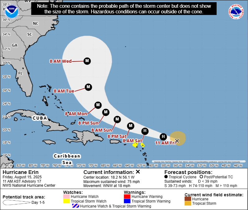
While the strengthening hurricane should pass well north of the northeast islands of the Caribbean, it will be sufficiently close enough for bands of squalls to the south of the center to move across those islands with localized rainfall amounts of up to 6”. Tropical storm watches are in effect for the northern Leeward Islands which are most likely to see stronger wind gusts associated with the hurricane.
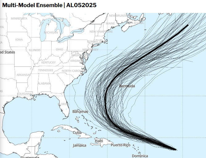
As far as the longer term track of Erin, as of right now the models continue to be consistent in showing the most likely track to be somewhere between the East Coast of the United States and Bermuda. The graphic above from Tomer Burg’s website shows the tracks from all of the major global models – American, European, Canadian, and UK – and provides a mean forecast of all of them. The overwhelming majority of tracks show this solution, with the handful that do not showing a track east of Bermuda.
Having said all that, the “closest” potential pass to the US East Coast is still almost a week away, far enough out that changes to the forecast large scale atmospheric pattern are still possible. I posted a note yesterday to share an example of what I am looking at in longer term models to monitor for any sort of concerning evolution in the forecast. Essentially, what I am trying to pull from the models when looking at a long term tropical cyclone forecast is: what weather features are primarily affecting the forecast track, and if their intensity or location are in error would that have a major impact on the forecast?
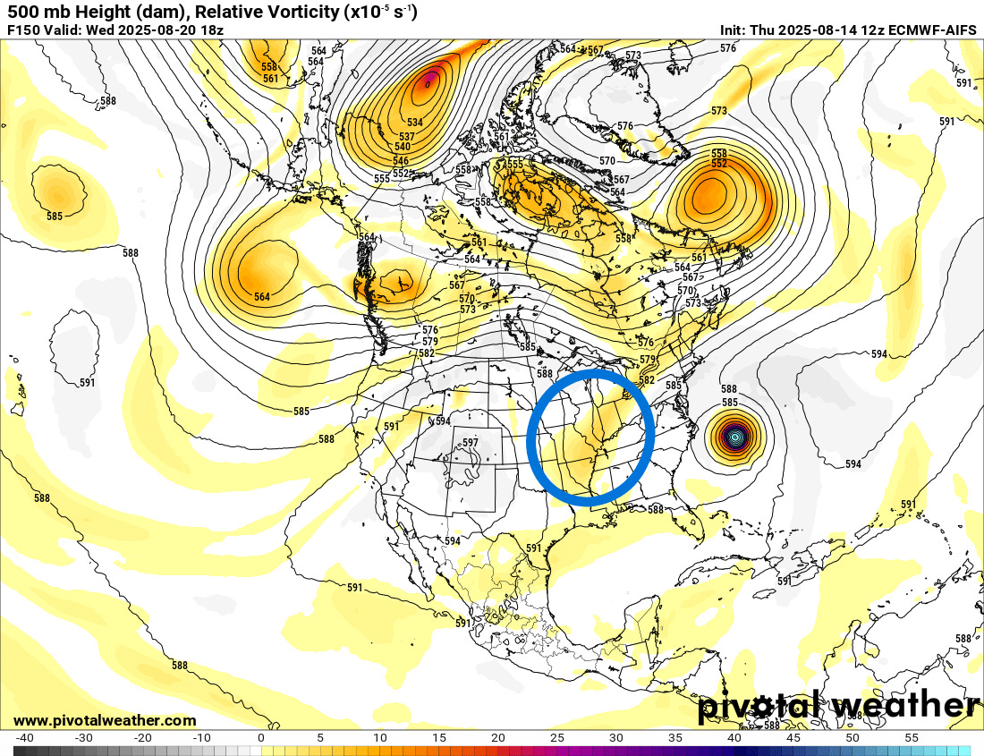
For Erin, a primary feature I am keeping an eye on is a weak upper low that most of the models are forecasting to develop the middle of next week in the vicinity of the Ohio Valley (yesterday’s European AI 500 millibar forecast shown as an example). If that feature were to end up significantly stronger than forecast, it would likely mean that the downstream area of high pressure over the southwestern Atlantic would also be stronger, and that could cause Erin’s track to shift notably to the west. As of this morning, I am still not seeing any signs of this showing up in the models, and obviously the closer we get, the less likely such a scenario is. Still, a tropical cyclone track forecast has a lot of parameters going into it — the large scale atmospheric features, the size of the tropical cyclone, the strength of the cyclone, the motion of the cyclone, etc. — so people along the East Coast and eastern Canada need to keep an eye on Erin for a bit longer. Obviously, Bermuda needs to be watching the hurricane very closely.
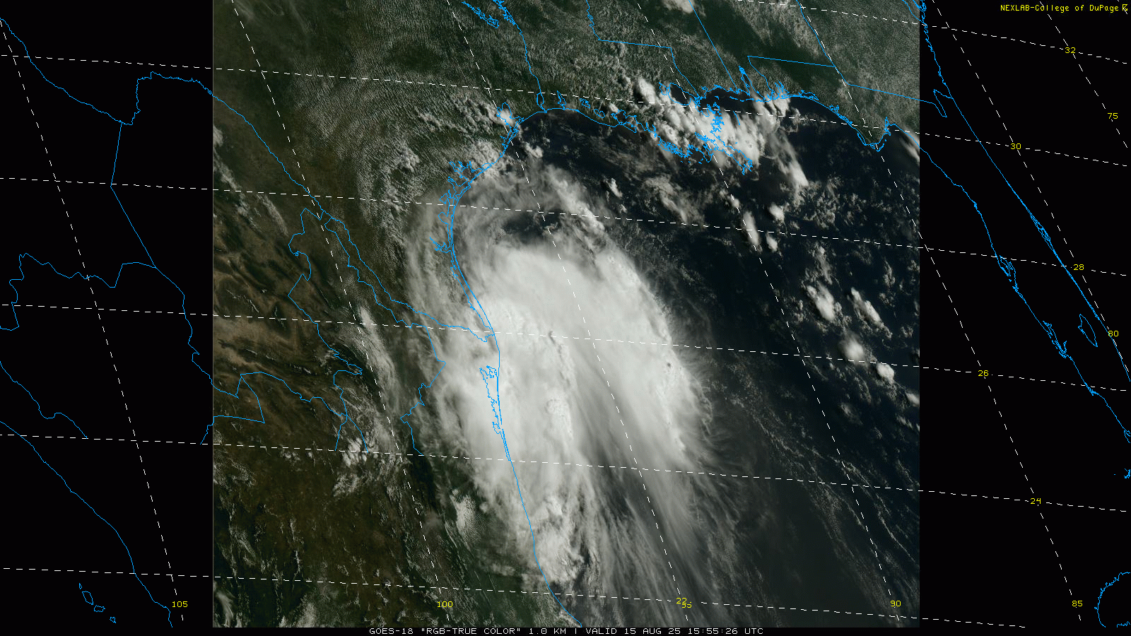
Reconnaissance aircraft have also been in the other tropical system we have been monitoring, Invest 98L which is now over the northwest Gulf. While satellite and recon data show the system is likely a bit better organized than yesterday, it also shows that is has moved quicker than anticipated and is already on the coast of south Texas and northeast Mexico. As a result, it has run out of time to develop, and NHC has dropped the potential to near zero.
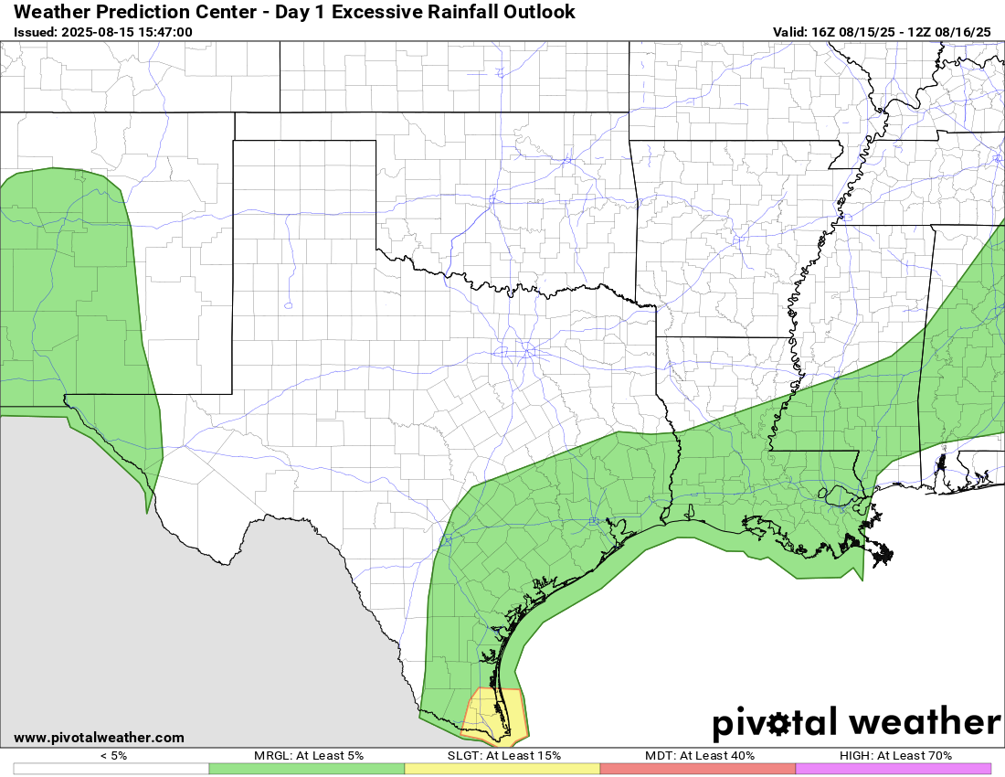
The system will enhance thunderstorm chances in south and southeast Texas, but as of now the threat of flash flooding does not look particularly high or widespread, with only the area right around Brownsville having a slight (level 2 of 5) risk of flash flooding.

Elsewhere across the country today, the main focus for severe weather and flash flooding risk will be in the upper Midwest, where an upper level weather disturbance moving around the north side of a large high pressure system centered over the middle of the country will focus thunderstorm activity this afternoon and evening. The primary focus for organized thunderstorm activity is expected to remain in the upper Midwest this weekend, and we could eventually be dealing with some more serious flash flood concerns in part of this region.
Monsoonal moisture flowing north into the Southwest will also bring some scattered strong storms to that region with gusty winds and some flash flooding. The Pacific Northwest will see some welcome rainfall as a storm system moves onshore over the next 24 hours.
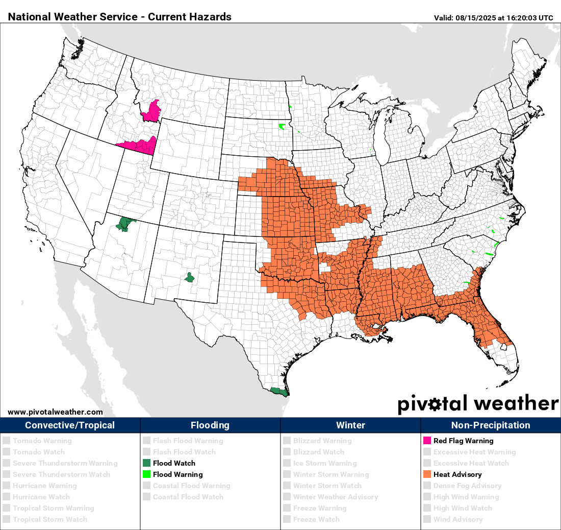
Yesterday was a busy wildfire day with 11 new wildfires reported across the country. Today will be a bit less dangerous day as far as as fire weather conditions in the West, but elevated fire danger and high based thunderstorms will continue be a concern in the Intermountain West, and a few areas remain under red flag warnings. The upper level high pressure center I talked about above will continue to bring oppressive humidity and above normal temperatures to much of the Midwest and Southeast today, and heat advisories are in effect for most areas.
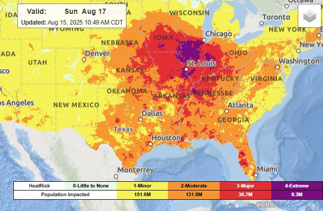
This heat dome is expected to build this weekend, and by Sunday much of the Midwest will be looking at major to extreme heat stress.
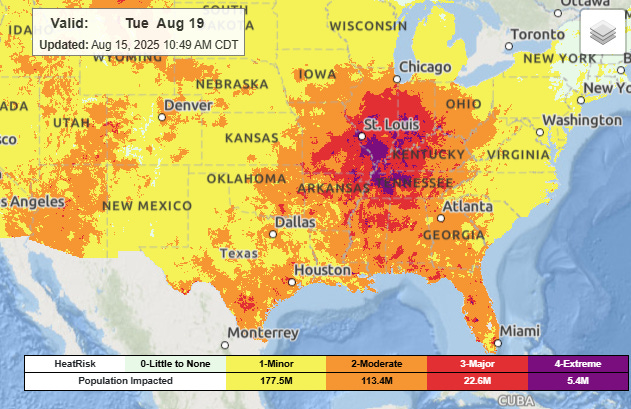
By Tuesday the heat is forecast to become focused over the Mid Mississippi and Lower Ohio Valley regions.
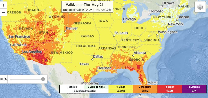
By Thursday of next week, a cold front will bring relief to much of the East, but a new dome of upper level high pressure will build over the West, bringing a new heat wave to that region. Record high temperatures look to be possible in parts of the Southwest yet again.

Leave a comment