Significant impacts likely to the Outer Banks of NC even as center passes well east
Aug 18, 2025
Good morning and welcome to a new work week. It’s Monday, so that means a deep dive into the tropics this morning — we’ll finish with an overview of what’s going on elsewhere.
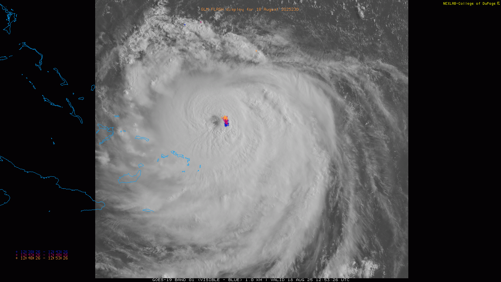
As expected, Erin finally completed its eyewall replacement cycle (ERC) late yesterday, and has been pretty steadily reorganizing and reintensifying since. The last aircraft reconnaissance pass through the eye found a central pressure of 935 millibars (mb), down about 10 mb from its pressure Sunday afternoon. Maximum sustained winds have increased to 140 mph, making Erin a category 4 hurricane once again.
![[Image of cumulative wind history]](https://substackcdn.com/image/fetch/$s_!fFMt!,f_auto,q_auto:good,fl_progressive:steep/https%3A%2F%2Fsubstack-post-media.s3.amazonaws.com%2Fpublic%2Fimages%2F73e3fc0a-9ffa-4423-ba00-a9c675f5f7f8_897x656.png "[Image of cumulative wind history]")
Probably the most important trend with regard to Erin’s structure in the last 36 hours is how the hurricane has grown much larger, which is a typical result of an ERC. The graphic above shows the coverage of tropical storm (orange) and hurricane (red) force winds as Erin has moved across the Atlantic, and you can in the last couple of days how the diameter of the storm has grown substantially. As my meteorological colleague Matt Lanza noted in his Substack post this morning, with hurricane force winds that extend 80 miles from the center, Erin is now in the 80th percentile as far as hurricane size — and NHC is forecasting it to grow even larger.
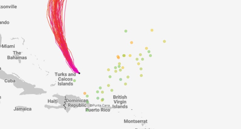
As the map above shows, with the growth in the size of the hurricane, it has gotten large enough that even with the eye passing well to the east of the Turks and Caicos islands and eastern Bahamas, tropical storm force winds are now occurring there. Even though it passed well north of the Caribbean islands, Erin also caused impacts in Puerto Rico and the Virgin Islands: at one point about 150,000 customers were without power in Puerto Rico and radar estimates show up to 10” of rain occurred in parts of the Virgin Islands.
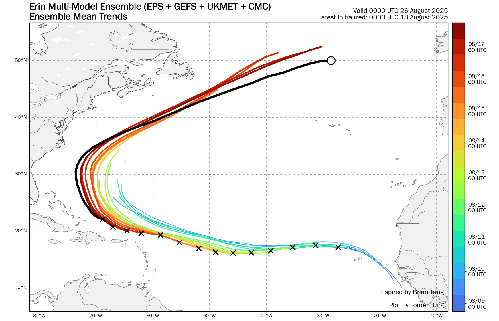
As has been the trend with Erin for the last several days, it has continued to move a bit to the left of its forecast track and the track has continued to shift to the west (black line above is the most recent model superensemble forecast track), at least for the next few days. While the center of the hurricane is still forecast to stay offshore of the US East Coast, its intensity and large size means that significant beach impacts will occur along East Coast beaches, with the most serious concern in the North Carolina Outer Banks region.

The Outer Banks are barrier islands that are connected by Highway 12. Coastal flooding and cuts to the highway have become an increasingly common occurrence in general across the area over the last number of years due to the sea level rise. With Erin growing in size and edging to the west, the probability of significant coastal flooding, beach erosion and damage to Highway 12 has increased, and as a result, local officials have issued evacuation orders for parts of the Outer Banks.
![[Key Messages]](https://substackcdn.com/image/fetch/$s_!W89X!,f_auto,q_auto:good,fl_progressive:steep/https%3A%2F%2Fsubstack-post-media.s3.amazonaws.com%2Fpublic%2Fimages%2Fe6cfc199-2f44-472a-b6b2-821ad6e00998_897x736.png "[Key Messages]")
Depending on the exact track and size of Erin when it makes its closest approach, tropical storm conditions now appear possible in the Outer Banks and NHC has noted that they may be issuing Tropical Storm and Storm Surge Watches for the Outer Banks later today. Life-threatening surf and rip currents are expected to be a serious issue along most of the US East Coast this week. As I talked about in this post about the tragic death of actor Malcolm-Jamal Warner last month, rip currents are a deadly threat, and when accompanied by high surf even more so. If you are going to be at an East Coast beach this week, obey posted signs and advisories and stay out of the water if conditions are dangerous.
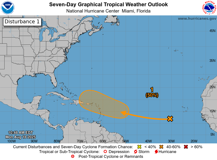
After Erin, the next system to focus on in the Atlantic tropics is a wave moving west across the eastern Atlantic Ocean. Conditions ahead of this wave look favorable for development, and the models are overall bullish on it. NHC has increased the probability of development to medium (50%) as it moves west and west-northwest over the next several days as shown above.
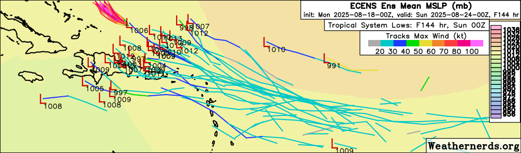
Over the next several days, the global model ensembles (ECMWF ensemble shown above) gradually develop a low pressure system and move it west-northwest in the general direction of or just north of the Leeward Islands of the northeast Caribbean. The passage of Erin will leave behind a large weakness in the subtropical ridge of high pressure that is a quasi-permanent feature of the Atlantic in the summer, and if an organized tropical cyclone develops more quickly out of this wave, it will likely “feel” that weakness and move north into it.
This is the scenario that the AI based models like the Google DeepMind AI system (5 day forecast shown above) have been showing with this system — although I will say its more recent runs have been slower with development and have shifted southwest since yesterday with many more members close to the northeast Caribbean islands. A large upper level trough of low pressure is forecast to be along the East Coast next week, so the more poleward any system gets, the more likely it will be recurved into the north Atlantic ahead of that trough. In any event, we still have many days to watch this system.
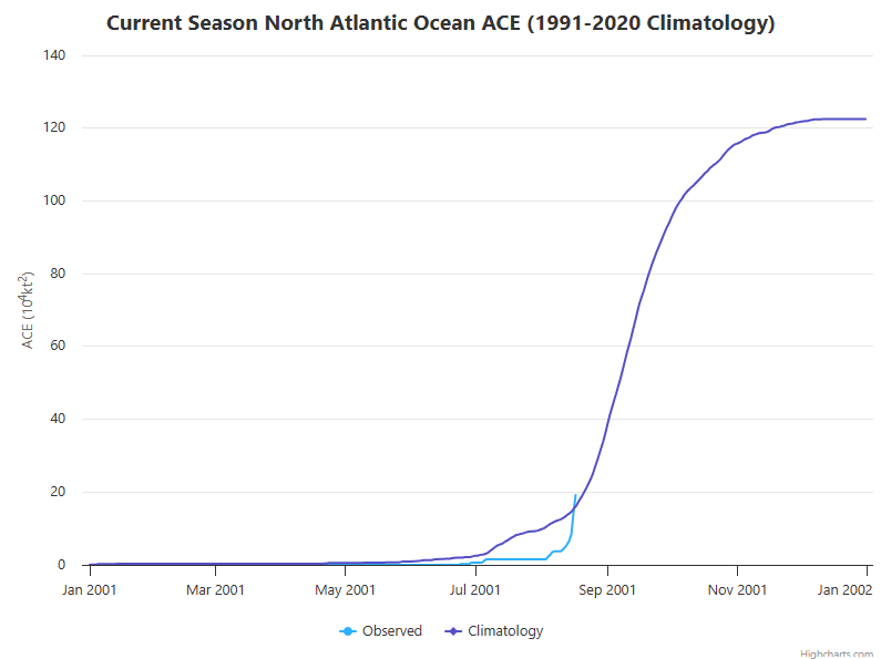
As far as the overall Atlantic season, the Colorado State University real-time chart of accumulated cyclone energy (ACE) — the parameter that best captures overall tropical activity in a season by integrating the size, intensity and longevity of each tropical cyclone — shows that Erin has made up for the slow start to the season and the Atlantic is now a bit above the “normal” ACE level for this point of the season. Erin will continue to add significant ACE for at least a few days. As I talked about in my Saturday post, having a system as intense as Erin this early in the season, especially outside of the Caribbean or Gulf, is rather unusual and suggests the Atlantic basin is overall in a favorable state for tropical activity. This of course doesn’t mean the next 6 weeks will be continually active of course — lulls and periods of greater activity are normal — but it is another data point supporting the 2025 seasonal outlook for somewhat above normal activity.
Elsewhere in the global tropics, the central and eastern Pacific look mostly quiet this week. There are pretty strong signals in the models for a tropical cyclone to develop in the western Pacific later this week and potentially be a threat the northern Philippines and eventually northern Vietnam or southern China.

Coming back stateside, a large dome of upper level high pressure will continue to dominate much of the central and south-central part of the country early this week. On the north side of this feature, upper level weather disturbances will pass through the Northern Plains and western Great Lakes regions, bringing risks of severe thunderstorms and flash flooding.
Underneath the heat dome, muggy conditions with above normal temperatures will result in major to extreme heat risk, and heat advisories are in place across much of the middle of the country, with extreme heat warnings for parts of the Mid-South where some record high temperatures are possible the next couple of days. A cold front has brought cooler weather to the Northeast, and by midweek another cold front will bring relief to the heat in the Midwest. However, a new intense upper level ridge of high pressure will develop over the Southwest for the middle and latter part of the week, and excessive heat watches are in effect for much of the Southwest. A number of record warm temperatures are possible in the West starting Tuesday.

Leave a comment