Also: lots of heat this week for many, and the latest on Erin and the rest of the tropics
Aug 19, 2025
Since Erin is looking quite a bit more disheveled this morning than anticipated (more later), I am going to start off this morning with some other topics. In scrolling through my social media this morning, I saw this incredible article posted on LinkedIn by the author. The article focuses around the recent experience of her 11 year old daughter, who was forced to evacuate with her father on a moment’s notice from the Los Angeles fires earlier this year, and then witnessed tragedy while at summer camp when a huge limb fell off a drought stricken tree, killing one of her young campmates and injuring many other people.
Not talked about in the article but discussed by the author in her LinkedIn post is that since the publication of the article, her daughter was supposed to go a different camp later this summer, and not surprisingly decided to not go. Almost unbelievably, that camp had to be evacuated two days into the session she was supposed to be attending because of the Gold Fire, distressing many of her friends who were at the camp. In summary — this 11 year old child has had three climate related traumatic incidents to deal with in less than 9 months.
This article really hit me this morning because I have been thinking a lot about seeing the word “rare” used by the media or public to describe recent weather disasters. The word came up a lot after the Texas flash floods. Recent “cloudbursts” that have caused devastating flash floods with hundreds of deaths in Pakistan and India were described as “rare” phenomena. Other events by their nature should be rare or unprecedented, like all-time records. Yet locations like Juneau, AK and Ruidoso, NM have seen all-time record floods multiple times in the last couple of years. Locations all over the globe from Japan to Spain are repeatedly setting national and regional all-time record high temperatures.
Scientists often say that any one particular weather event cannot be linked to climate change, and that is true. However, what we are doing with climate change is “loading the dice” by making the planet hotter and making it more susceptible to extremes in both dryness and wetness.

The severity and frequency of weather events can be visualized along a normal distribution using a standard bell curve like the one above. Events like all-time record hot temperatures and record floods should be out at the far right tail — 99.9 percentile events. When we make the planet hotter — which also makes the atmosphere able to hold more moisture — we are shifting that curve to the right, meaning heat and flood events that once were 99.9 percentile events are now much more frequent. We are making it more likely that young children (and of course, all of us) are going to experience climate related tragedies more and more frequently — and sometimes even 3 times in 9 months.
I have stated before that a primary reason I wanted to do this Substack was to provide hype-free, science based weather information as an antidote to the increasing prevalence of clickbait. While some of the climate change headlines you see in the media are certainly clickbait as well, I think it is important that I share my perspectives on what I perceive as the real impacts of climate change as someone who has been deeply ingrained in weather for more than 35 years. All of the science I see as well as my own experience tell me that we are treading dangerous ground when it comes to our climate and planet and setting ourselves up for more tragic weather and water events in the future — especially if we also keep reducing our investments in the scientific and public safety institutions (e.g., emergency management) that are supposed to help us understand what is happening and keep us safe. We need to be clear eyed about what we are truly facing if we are to work together to try to reduce the negative impacts to our society.
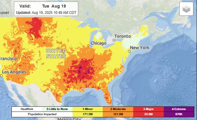
Now to today’s weather. Heat will be the main weather impact in the US this week. Another day of oppressive humidity and near record temperatures will result in widespread major to extreme heat risk across the Mid and Lower Mississippi Valley regions where heat advisories and extreme heat warnings are in effect. The next heat wave will begin building in the western United States today, and heat advisories and extreme heat warnings/watches are in effect for parts of the northern Rockies and Southwest.

With plenty of moisture in place, scattered to numerous thunderstorms can be expected across much of the country today. The risk of organized severe weather or flash flooding looks to be limited, but obviously at this time of year some isolated strong storms and flash flooding are always a possibility with the most intense storms.
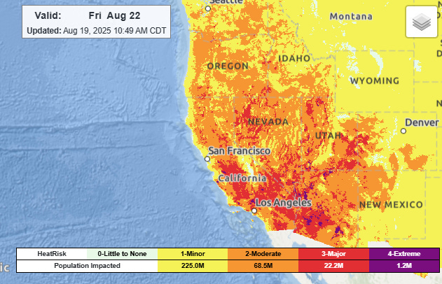
By late in the week, a series of cold fronts will bring relief from the heat to the Midwest and much of the Southeast, while the heat dome will build along the West Coast. A number of record warm temperatures are likely this week from the Rockies west. Periods of elevated fire danger with high-based thunderstorm activity will also occur in the West through the week.
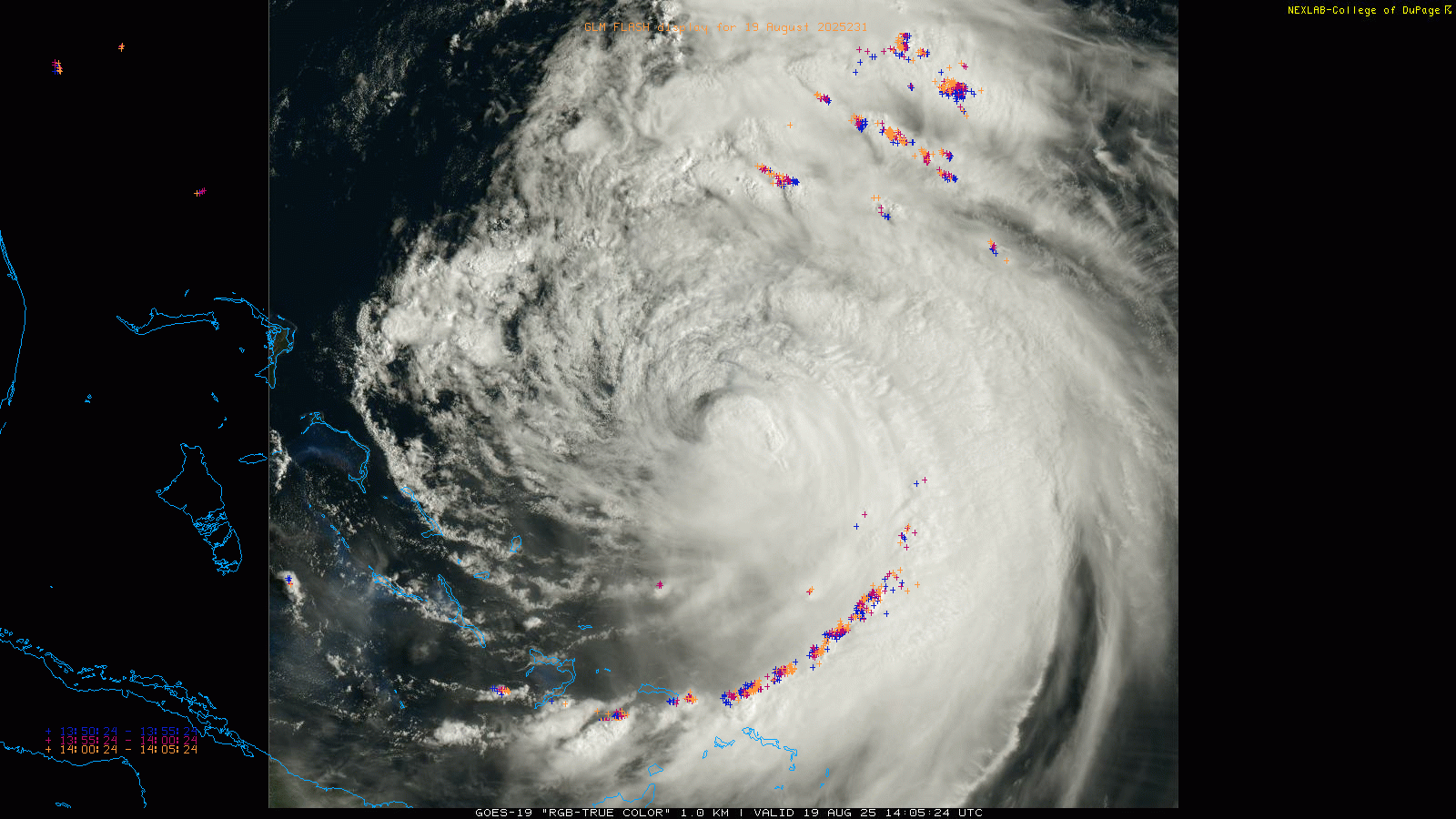
Erin continues to be a confounding system to deal with. After a period of restrengthening yesterday morning, over the last 24 hours it has weakened rather substantially (and unexpectedly). Reconnaissance aircraft in the storm this morning found that the central pressure has increased to 961 millibars (mb), up about 15 millibars from this time yesterday. Maximum sustained winds are down to 105 mph, a category 2 hurricane.
Upper level west and northwesterly winds are clearly imparting shear onto the system, as much of the thunderstorm activity this morning has been blown to the south and east side of the system. However, this shear is forecast to relax, and just in the last couple of hours, the visible satellite loop shows that thunderstorms look to be starting to wrap back around the northern side of the center, a sign that the shear may indeed be lessening. Erin has been moving slower than anticipated as well, and because of that it has likely been working with increasingly cooler sea surface temperatures due to its own persistent presence over the water. Once it starts moving more rapidly again to the northwest and north, it should be back over warmer water supportive of strengthening. Given all of these trends, NHC forecasts Erin to reintensify a bit over the next couple of days, and be at the border of a category 2 to 3 hurricane as it makes its closest approach to the North Carolina Outer Banks.
![[Image of cumulative wind history]](https://substackcdn.com/image/fetch/$s_!BugF!,f_auto,q_auto:good,fl_progressive:steep/https%3A%2F%2Fsubstack-post-media.s3.amazonaws.com%2Fpublic%2Fimages%2F6208f34d-f6c4-4428-b2be-c11c953ee3e9_897x656.png "[Image of cumulative wind history]")
Erin’s peak intensity may have come down a bit, but its size has not, and it is expected to grow even larger over the next couple of days.
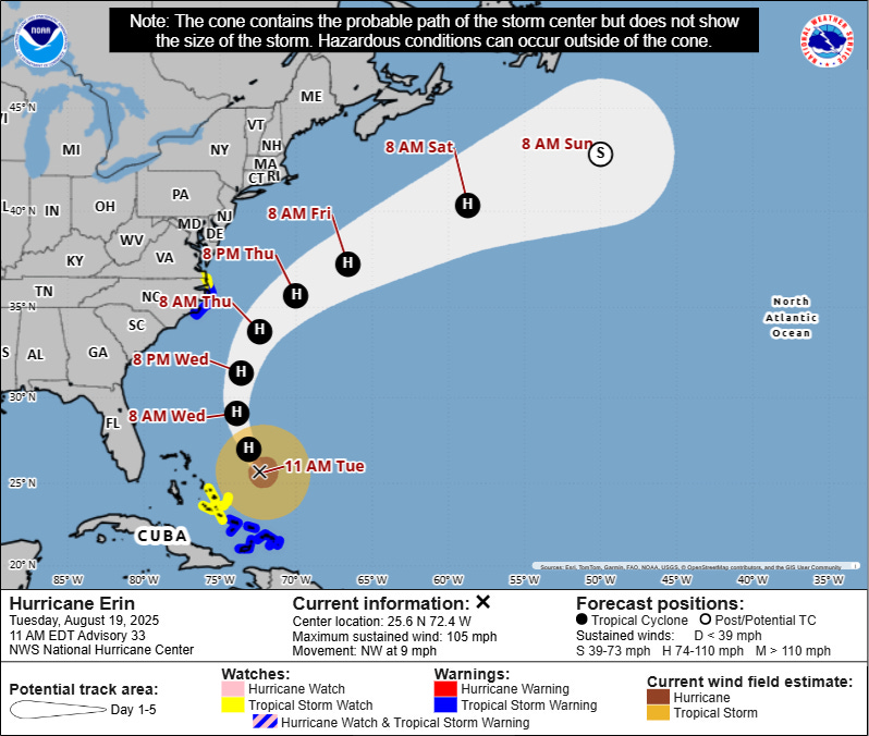
Given that growth in size and the continued drift to the west of the forecast track, tropical storm conditions are now expected in the Outer Banks of North Carolina, and tropical storm and storm surge warnings are now in effect there.
![[Key Messages]](https://substackcdn.com/image/fetch/$s_!Vlfu!,f_auto,q_auto:good,fl_progressive:steep/https%3A%2F%2Fsubstack-post-media.s3.amazonaws.com%2Fpublic%2Fimages%2Ff1f37082-a2c6-47e9-ae47-4f0338c1b4f8_897x736.png "[Key Messages]")
NHC is currently forecasting up to 4 feet of surge along the Outer Banks along with very large waves and surf, meaning that significant beach erosion and overwash with road closures are likely. Life-threatening high surf and rip currents are expected up and down the East Coast the next few days.
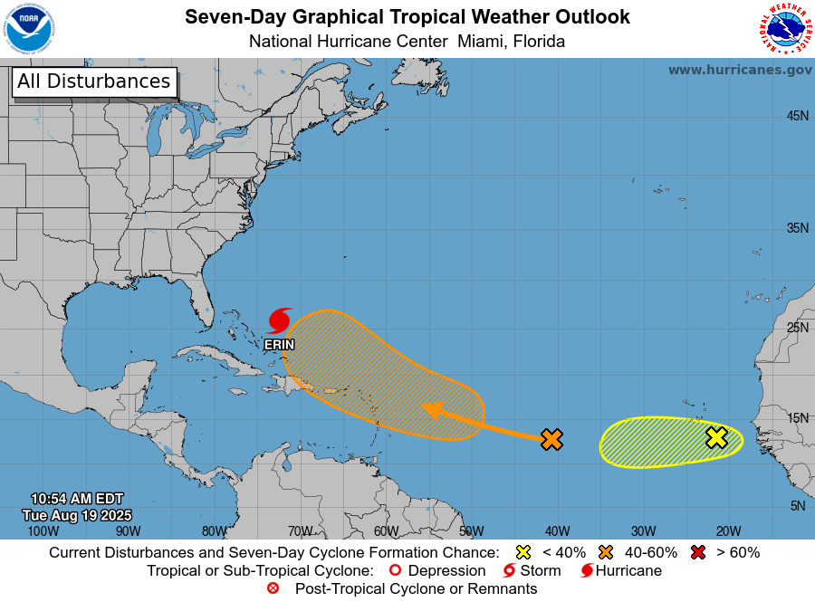
Elsewhere in the tropics, the trailing tropical wave we have been discussing is now in the central Atlantic, moving west. It has limited organization right now, but is still forecast to gradually become better organized and NHC has a 60% probability of it developing into a tropical cyclone over the next several days. However, all of the model guidance has come into better agreement today on the idea that this system will recurve over the north Atlantic, likely well to the east of Erin’s track.
Another system has emerged off the west coast of Africa that actually looks much better organized than the system farther west, and it has been designated Invest 99L by NHC as it has some potential to develop into a tropical cyclone over the next day or two. However, it should encounter more hostile conditions as it moves to the west and is unlikely to make it across the Atlantic as a tropical cyclone. At this time of year, though, we will want to keep an eye on it regardless of development as it looks to take a more southern track than Erin and its trailing wave.

Leave a comment