Significant coastal flooding, beach erosion and rip currents up and down the coast
Aug 20, 2025
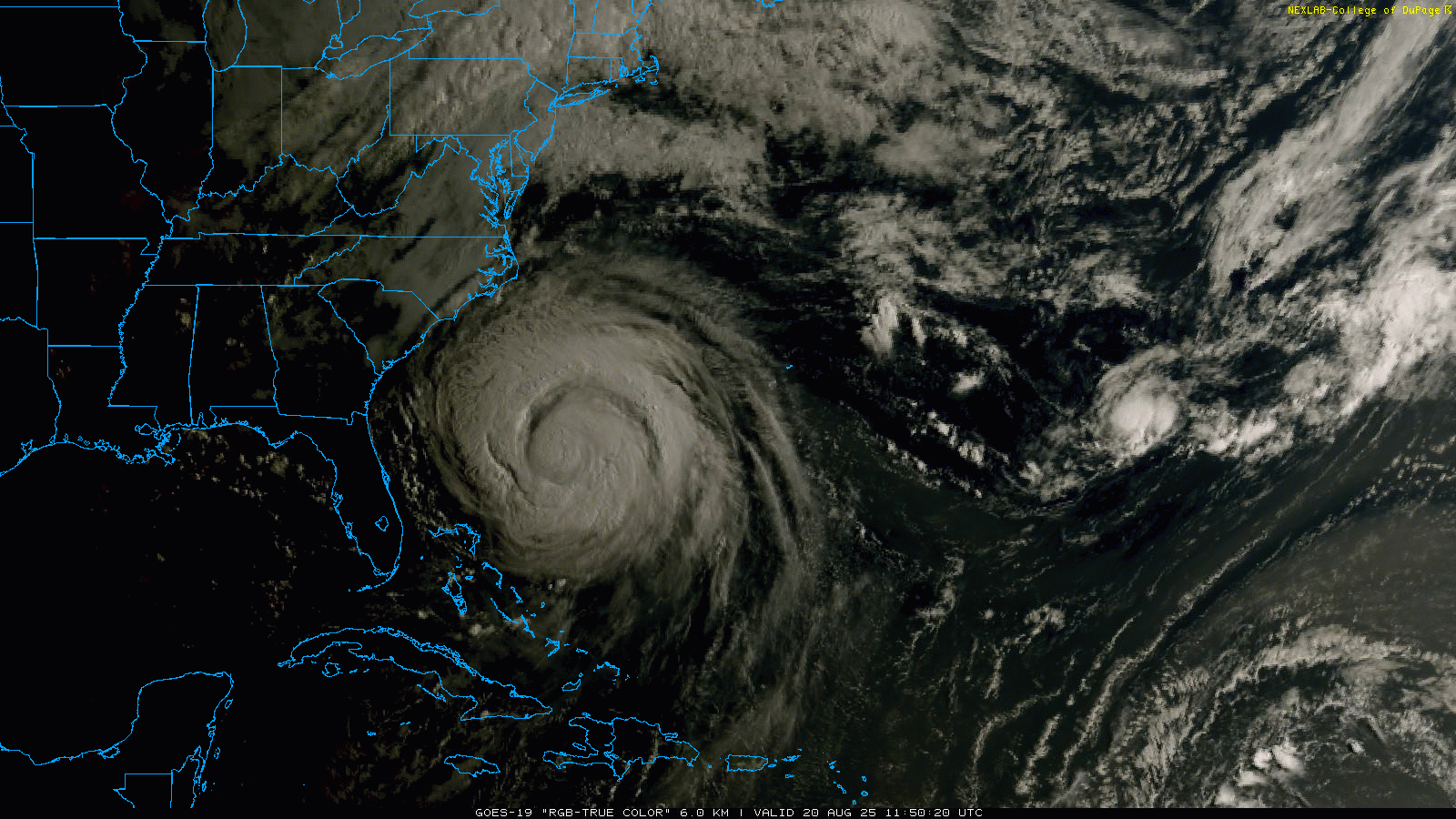
The morning visible satellite imagery shows an amazing view of massive Hurricane Erin, centered just about due east of Jacksonville and 365 miles south-southeast of Cape Hatteras, NC. The satellite trends we saw yesterday morning of decreasing wind shear and improving conditions for intensification were borne out over the last 24 hours. The eye is clearly visible in satellite imagery once again, and reconnaissance aircraft in the storm have found that the central pressure of Erin has dropped 20 millibars (mb) since this time yesterday to 941 mb, an impressive rate of intensification. Maximum sustained winds are back up to 110 mph, putting Erin on the threshold of becoming a category 3 hurricane once again.
![[Image of cumulative wind history]](https://substackcdn.com/image/fetch/$s_!gEGX!,f_auto,q_auto:good,fl_progressive:steep/https%3A%2F%2Fsubstack-post-media.s3.amazonaws.com%2Fpublic%2Fimages%2F0ff6601b-ff9f-4bbb-a094-3fc2a235244e_897x656.png "[Image of cumulative wind history]")
As we have been stressing the last few days, the feature of Erin now that is most impressive and which will cause the most headaches for the East Coast is its size. As low as the pressure is at the center of Erin right now, a “normal” hurricane would actually have stronger winds. That suggests that the lowering pressure – what meteorologists refer to as “deepening” – is actually going more into making the hurricane bigger rather than more intense. You can see in the satellite imagery the huge size of the storm – the leading edge of upper level clouds are already streaming on to the North Carolina coast. Hurricane force winds now extend up to 90 miles from the eye and tropical storm force winds up to 260 miles from the center.
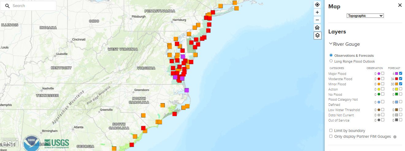
Erin’s combination of intensity and large size is why even though the center of the hurricane will pass well offshore, impacts along the coast will still be significant. Widespread moderate to major coastal flooding is anticipated as shown on the map of forecast tidal gauge levels (orange=minor, red=moderate, purple=major). When combined with anticipated very large waves and surf, this means beach erosion will also be a particular concern, particularly in the North Carolina Outer Banks and Virginia Tidewater, where storm surge will reach up to 4 feet above ground level. Tropical storm warnings are in effect for this area as well.
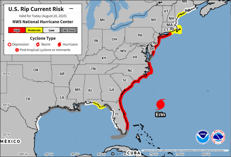
It is really not possible to overstate how dangerous beaches along the East Coast will be this week for swimming – or even for being close to the water. Huge waves and surf and strong rip currents will make water conditions truly life-threatening — dozens of water rescues had to be executed by lifeguards along East Coast beaches yesterday, and conditions will only worsen today. Many beaches have been closed to swimming – and even if you are at a beach that hasn’t been closed, I would strongly advise staying out of the water.
Bottom line – Erin will be an impactful, problem storm for the East Coast even with it staying offshore; it could have been a lot worse with a closer pass or landfall.
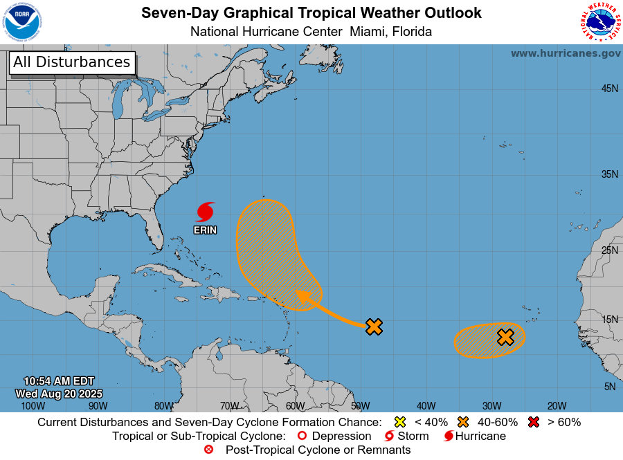
Elsewhere in the tropics, NHC has tagged two areas with moderate probabilities of development into a tropical cyclone. The first area of interest is the tropical wave over the central Atlantic. It is producing some shower and thunderstorm activity as it moves west but has little in the way of organization. Conditions ahead of it look favorable and most of the models are pretty bullish on it developing into at least a tropical storm (although the European ensemble is the least enthused). Regardless, it now seems clear it will recurve on a track well east of Erin — which could mean some risk to Bermuda.
Invest 99L in the eastern Atlantic is showing signs of increasing organization in morning satellite imagery, and it would not surprise me to see this system become a short lived tropical depression or storm during the next 48 hours. However, conditions are expected to become more hostile the farther west it goes, and as of now it is not expected to move all the way across the Atlantic as an organized cyclone. It is farther south than the other systems, though, so even as a wave it will be worth keeping an eye on given we are in the heart of the hurricane season.
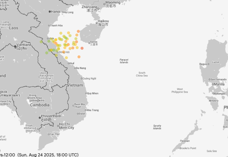
While the eastern Pacific remains quiet, the models are in pretty strong agreement that a system developing just east of the northern Philippines over the next couple of days will likely intensify as it moves west and could become a rather strong typhoon before it reaches the coast of northern Vietnam this weekend (Google DeepMind AI model ensembles for midday Sunday US time shown above). This will be a system to keep an eye on for potential significant impacts to this region.
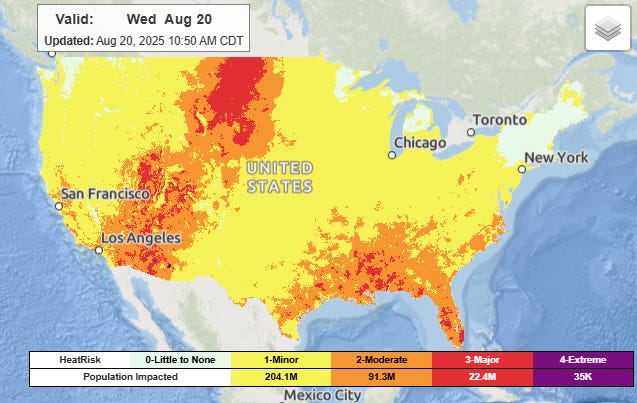
For the rest of the US away from the East Coast, heat continues to be the biggest impact story this week. A number of record high temperatures were set yesterday in the Intermountain West and in the Mid-South, including 101F at Memphis which established a new record for the date. A cold front dropping south through the Midwest is bringing relief into that region, but the Southeast will remain under moderate to major heat stress today while heat continues to build over the West.
By late in the week, record heat will be prevalent over much of the West, with a number of record high temperatures expected on Friday (above).
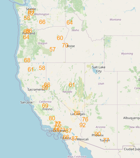
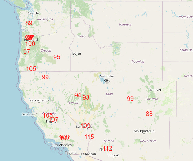
As is now often the case, record warm minimums will be even more prevalent than record highs, with numerous records expected in the West both Saturday and Sunday (shown above). Heat advisories and extreme heat warnings will be in effect for many areas of the West into the weekend.
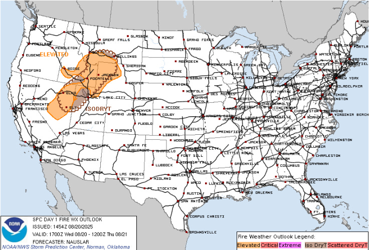
With the hot and mainly dry weather in the West, fire danger will once again become an increasing concern. For today, the intermountain region will see a combination of dry and breezy conditions along with elevated high based dry thunderstorms with lightning, all of which could increase fire activity. The National Interagency Fire Center (NIFC) in their daily fire summary and outlook stated that a significant escalation in fire activity is expected in this region today, and that into the weekend “hot temperatures and dry lightning may bring more fire starts across much of the Intermountain West and California.”

Leave a comment