Cuts target the GeoXO geostationary satellite program
Aug 21, 2025
On Wednesday afternoon, Andrew Freedman of CNN reported that multiple NOAA sources told him that the administration is moving forward with plans to reduce the instrumentation targeted for inclusion on the next generation of NOAA’s primary weather satellites. Along with reducing the number of instruments, the administration is also planning to reduce the number of satellite launches in the agency’s GeoXO program from six to four.
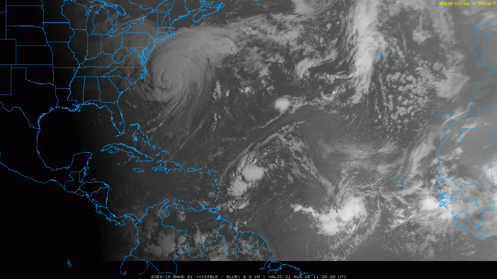
GeoXO is the next planned phase of our country’s geostationary weather satellite program. Geostationary satellites are so named because they orbit at a point 22,236 miles above the earth, enabling them to remain stationary over the same point of our planet. This allows them to gather data from the same consistent spot, providing the fantastic animations of weather features that we have all come to take for granted, like the one above of sunrise over the Atlantic this morning.

The NOAA line office responsible for satellites is the National Environmental Satellite, Data and Information Service (NESDIS), and you can find a great history of the use of geostationary satellites on their webpages here and here. The first experimental geostationary satellites were launched by NASA in the late 1960’s and early 1970’s, which evolved into a proof-of-concept project jointly operated by NASA and NOAA in the mid 1970’s. The first satellite that was an official part of the Geostationary Operational Environmental Satellite (GOES) program launched on October 16, 1975. The GOES program is managed by NOAA with support from NASA.
The early GOES satellites were only able to view Earth ten percent of the time because of their spin control system, but since 1994 all GOES satellites have “three axis stabilizing” systems which allow the satellites to view the planet continuously. GOES satellite development and launches have been done in a cadence to try to ensure that there are always three satellites in orbit: GOES-East at 75W longitude, GOES-West at 137W longitude, and then a spare satellite that can replace either of the operational GOES satellites if a failure occurs. Usually the spare is “stored” around 105W.
I think it is fair to say that the advances that have been made in the GOES satellite program, and particularly the imaging and instrumentation aboard the satellites, have been remarkable and have revolutionized meteorology during my career. When the most recent GOES series of satellites starting with GOES-R were in development in the early to mid 2010s, the GOES program undertook an extremely successful outreach program with NWS meteorologists and the broader weather community to provide training on how the new instruments would radically improve data quality and how the new data could be used operationally. This truly built excitement and high expectations among the meteorological community, and once the new arrived, for me anyway, it exceeded everything hoped for.
This GOES program webpage describes all of the instruments aboard the current GOES satellites. The new satellites radically improved the spatial and temporal resolution of the imaging data, allowing high resolution, up to 30-second monitoring of specific areas of interest such as tropical cyclones or severe weather episodes, as well as improved sounding capabilities. For the first time, the GOES satellites included a GOES Lightning Mapper (GLM) instrument, which enables meteorologists to continuously track lightning activity, which for example has revolutionized our ability to monitor lightning activity with tropical cyclones and better understand how lightning trends can improve forecasting of intensity changes with hurricanes. GOES satellites now also have a number of instruments that have radically improved our space weather monitoring and forecasting capacity.
I have been meaning to do a deep dive on the GOES program because it is such an important story of how government led science and technology improvements have made a difference to our society; and I felt it was important to do it today, to frame what is in danger of being lost with the current administration’s plans to cut the GeoXO project.
GeoXO (Geostationary Extended Observations) would be the next phase in the nation’s geostationary environmental satellites. It is envisioned as a system that “will expand observations of Earth that the GOES-R Series currently provides from geostationary orbit. The information GeoXO supplies will address emerging environmental issues and challenges regarding weather, the ocean, and the climate that threaten the security and well-being of everyone in the Western Hemisphere. NOAA expects that GeoXO will begin operating in the early 2030s as the GOES-R Series nears the end of its operational lifetime.” As outlined on the GeoXO webpage, the new series of satellites are slated to have improved imaging, lightning mapping and sounding instruments, as well as instruments for air quality monitoring and ocean monitoring.
When the Office of Management and Budget (OMB) released its 2026 proposed NOAA budget document back in April, I wrote about the devastating cuts outlined for the agency. GeoXO was a program that was specifically targeted in that document for radical changes, including canceling all major instrument and spacecraft contracts, elimination of NASA as a partner, and essentially restarting the program with a focus to “deliver exclusively on NOAA’s weather data needs, therefore the program will de-scope the atmospheric composition and ocean color instruments.” The document also directed NOAA/NESDIS to develop a program redesigned to fit budget constrats (sic), not maximize new capabilities,” meaning that the inclusions of sounder and lightning mapping instruments could only go forward if they could be justified and fit within the new OMB budget levels.
Since April, Congress has worked on their own budget plans for FY2026, and have pretty much stated their intent to reject most the administration’s desired cuts for NOAA. The Senate bill that passed the Appropriations Committee pretty much completely pushes back on the administration’s intent for GeoXO, and would require NOAA to develop a new “mission architecture” before canceling any part of the current planned program:
Given rapidly changing weather patterns including severe weather, the Committee believes the revised mission architecture must include imaging and sounding as the core instruments for all satellites with data quality standards that meet or exceed GOES– R requirements and to consider additional instruments if they can be accommodated under a lower life cycle cost cap. Before NOAA terminates any current program elements, the agency must submit a revised mission architecture, including component costs and planned launch schedule to the Committee.
Of course, none of what Congress is working on is law yet, and in fact is nowhere near being law. Yesterday’s reporting by CNN is essentially showing that the administration is moving forward with its plans for GeoXO and the nation’s geostationary satellite program as outlined in the OMB NOAA budget document regardless of Congressional action or intent.
Perhaps I am being a bit hyperbolic, but it certainly seems as if what the administration is wanting to do is essentially take the nation’s state of the art, global leading Land Rover level geostationary satellite program and replace it with a Honda Civic. Under this vision, we would still have the basic ability to monitor weather features using imager data, but most of the operational and research gains we have realized with the improved instrumentation of the GOES-R series of satellites would be lost.
As far as the new air quality and oceanic instruments, the administration seems to be targeting these because of a view that they are somehow climate change related — but obviously, better understanding of air quality/composition and oceanic chemistry are hugely important to weather monitoring and forecasting as well. Just focusing on the air quality/composition instrument for a moment, we have spent the last several months dealing with air quality issues across large swaths of the country due to Canadian wildfires and dust storms. Having an instrument that could better monitor and track areas of air quality issues for alerts and forecasts in such situations would be very beneficial. Additionally, recent research is showing that aerosols and atmospheric composition play an important role in the development and evolution of thunderstorms, and better data from this instrument could help further that research and possibly move us toward utilizing that knowledge toward better prediction.
The elimination of two satellites and launches would also be a risky strategy, as it would essentially dramatically increase the likelihood of not having a spare satellite in orbit to replace any satellite that might fail. As my colleague Chris Vagasky noted on BlueSky last night, there is precedent within the GOES program for backup plans to have to be utilized, so if this reduction moves forward it could leave the US at some point with a hole in its satellite coverage.
Obviously, at some level all government programs come down to budgetary decisions, but one of my goals with this Substack is to explain governmental science programs so people can have a true understanding of what may be lost with budget cuts. I am a firm believer that the value our society has realized from NOAA’s satellite programs has been tremendous, and I want people to understand what is at risk if we step as far backwards as the administration is proposing. I also think it is important for people to see that the administration is not waiting for Congress to provide guidance (or pushback) on these plans, and at any time they could start moving forward with other aspects of their FY26 budget plans for NOAA, including elimination of NOAA Research (Office of Oceanic and Atmospheric Research).

Leave a comment