Watching Kiko and Lorena in eastern Pacific for potential US impacts
Sep 03, 2025
Back in March, the President signed an executive order (EO) that exempted a number of federal agencies from being able to participate in collective bargaining with employee unions, using a part of the 1978 Civil Service Reform Act that allows the president to suspend collective bargaining if they feel that national security is risked. While a number of the affected unions filed a lawsuit against the EO, the court allowed the EO to remain in effect as long as the administration did not begin formally terminating collective bargaining agreements (CBA). However, per this article in Government Executive, the administration has terminated several CBAs in recent months, and because of this the court is reconsidering allowing the EO to remain in place.
Regardless, last week, the President signed a new EO that added a number of agencies to the original list of agencies affected by the March EO. This included the National Weather Service, a move that had been expected (at least by me) since the administration had added the NWS to its list of public safety agencies. Since 1976, non-management NWS employees have been represented by the National Weather Service Employees Organization (NWSEO), and over the years NWSEO has come to represent NOAA employees in a number of other workgroups around the broader bureau.
The most recent NWS-NWSEO collective bargaining agreement was negotiated in 2021, and recently updated in November 2024. Within the existing framework of federal statute and policy, the CBA governs various NWS workplace topics like scheduling, overtime, grievances and discipline, and since NWS has a number of employees who work in remote or hazardous locations, things like safety, health, and government housing. I have recently heard from multiple colleagues who still work for NWS that the administration has in fact terminated this CBA in the wake of the new EO issuance last Thursday. NWSEO had already filed a lawsuit earlier this week challenging the validity of the EO, so it is quite possible that there will be court interventions on this. However, it seems clear that the intent of the administration is to operate the NWS going forward as if there is not a CBA (or, effectively, an employee’s union) unless a court orders them otherwise.
I am not going to speculate on how Department of Commerce or NOAA/NWS leadership intend to implement this change. What I will say is that the management-union relationship is an ingrained part of the NWS workplace culture that governs many aspects of day to day life in NWS field offices that operate continuously in support of public safety. Terminating the CBA right now potentially adds another layer of instability to an agency already struggling with the effects of staffing cuts/shortages and insufficient resources.
While NWS is currently in the process of hiring a first wave of 125 or so employees (meteorologist jobs were advertised in the last week) to replace the hundreds lost earlier this spring to early retirement, even getting this first wave of new employees on board and spun up into new positions will take many months. As we approach peak hurricane season and wildfires continue to grow and impact communities (see below), the NWS will be dealing with staffing shortages and other resource challenges for the foreseeable future, many of which are self-inflicted by the administration.
Bottom line: the cavalier way in which this administration has handled staffing, administering and managing an agency which even it now acknowledges is a critical public safety agency is infuriating to me as not only someone who worked there and knows its value, it angers me as a citizen and taxpayer concerned about the safety of myself and other Americans. And of course these sorts of issues are not limited to the NWS, I could (and likely will at some point soon) write an entire piece about what is happening to FEMA and the emergency management structure of our country. Weather related disasters do not happen on our desired timeline, and my concern for our ability to handle them in the near future as effectively as we could and should continues to grow.
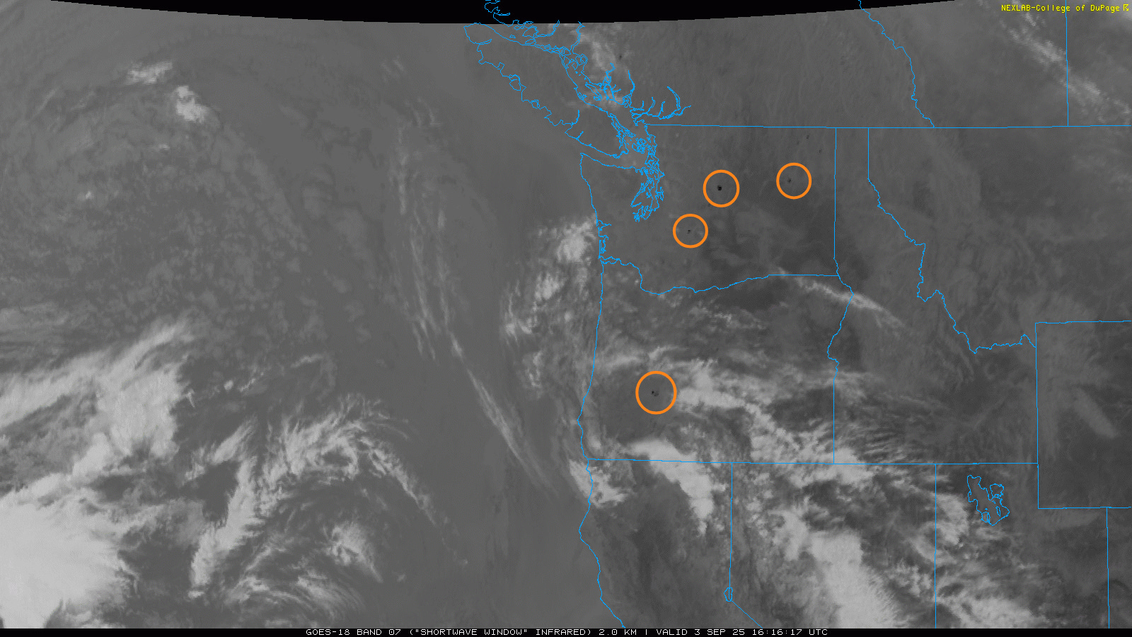
As we talked about yesterday, thunderstorms with limited rainfall moving through the northwest United States over the last 24 hours caused serious fire weather issues, with numerous new wildfires started by lightning strikes. The historic Gold Rush town of Chinese Camp, CA, east of Stockton, was heavily damaged last night by a fast moving wildfire started by lightning. While no casualties have been reported, many structures in the small town were destroyed, including the historic post office which had been built in 1854 and was still in operation today. This wildfire has rapidly grown to over 6,000 acres and has 0% containment. Shortwave infrared GOES satellite images this morning show the hotspot signatures of several new large wildfires now burning across parts of Oregon and Washington as well (highlighted in orange circles above).
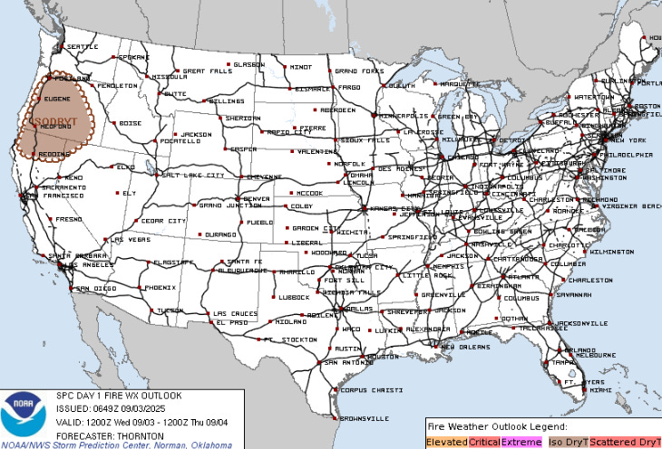
Additional thunderstorms with limited rainfall are anticipated today across parts of the Pacific Northwest (brown scalloped area above) along with record heat, so it is likely that additional wildfires — along with poor conditions for fighting current wildfires — will be seen today.
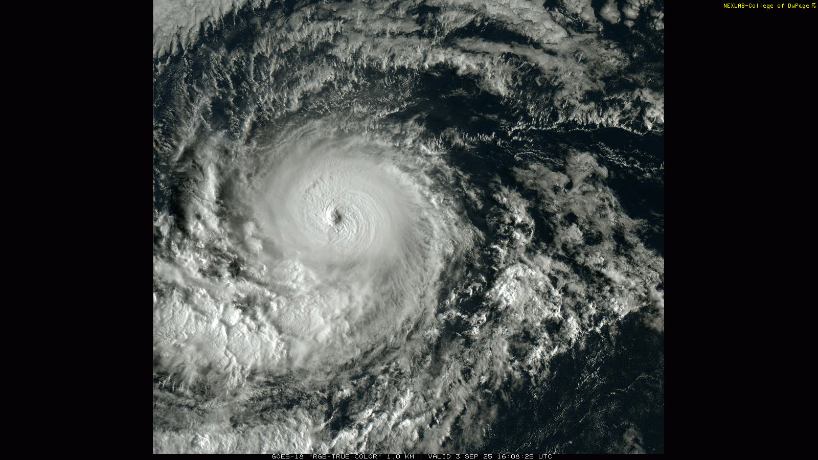
Turning to the tropics, Kiko has continued to quickly intensify, and is now on the threshold of becoming a major hurricane well to the east-southeast of the Hawaiian Islands. NHC forecasts it to peak at the threshold of a category 3 to 4 hurricane in about 36 hours, and then start to slowly weaken as it turns more west-northwest and encounters cooler water and increased wind shear.
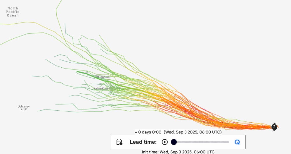
There has been a bit of a shift in the longer term model trends with Kiko, as the European ensemble members have shifted north toward the Google DeepMind forecast, and the Google ensembles themselves have also shifted a bit north with their mean forecast — the thick line above — showing a weakening tropical storm/depression moving across the Hawaiian Islands in about a week. While on this track Kiko would likely be (rapidly) weakening as it encounters cooler waters and increased wind shear, a track farther north could mean increased rain and — if the system tracks close enough — some wind, especially at higher elevations. Plenty of time to still to watch this, but if you happen to be in Hawaii or planning a trip there, certainly Kiko is worth keeping an eye on.
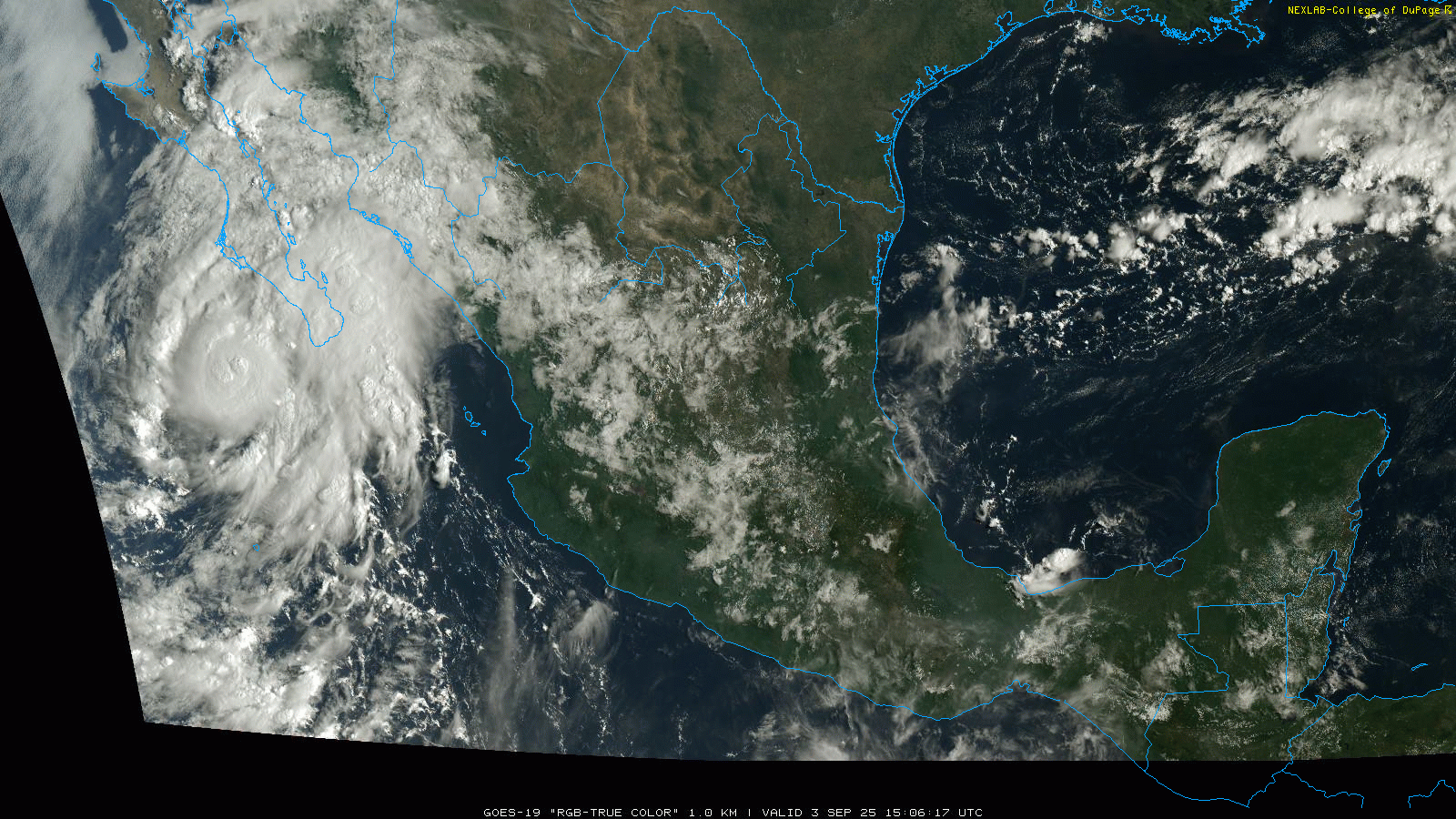
Meanwhile, Lorena has also intensified over the last 24 hours. In fact, it has gotten a bit stronger than forecast and become a low end category 1 hurricane as it passes west of the southern tip of Baja California. An Air Force Reserve Hurricane Hunter aircraft is currently en route to Lorena to provide a better estimate of the current intensity.
![[Key Messages]](https://substackcdn.com/image/fetch/$s_!CBS_!,f_auto,q_auto:good,fl_progressive:steep/https%3A%2F%2Fsubstack-post-media.s3.amazonaws.com%2Fpublic%2Fimages%2Fe2d4d014-67f8-47de-a694-e63a5af683d4_897x736.png "[Key Messages]")
Lorena should start to weaken soon as it encounters cooler waters. There remains quite a bit of uncertainty in the track of Lorena as the models are split on whether the system turns more northeast into Baja California and eventually northwest Mexico, or turns west into the open Pacific. The track forecast is made more complex by the fact that it greatly depends on how quickly Lorena weakens, as a stronger system is more likely to move northeast while a weaker system would be more likely to turn west. Regardless, moisture from Lorena will be carried northeast by mid and upper level winds toward northwest Mexico and the desert Southwest, and should enhance rainfall and flash flood potential in this region the next few days.
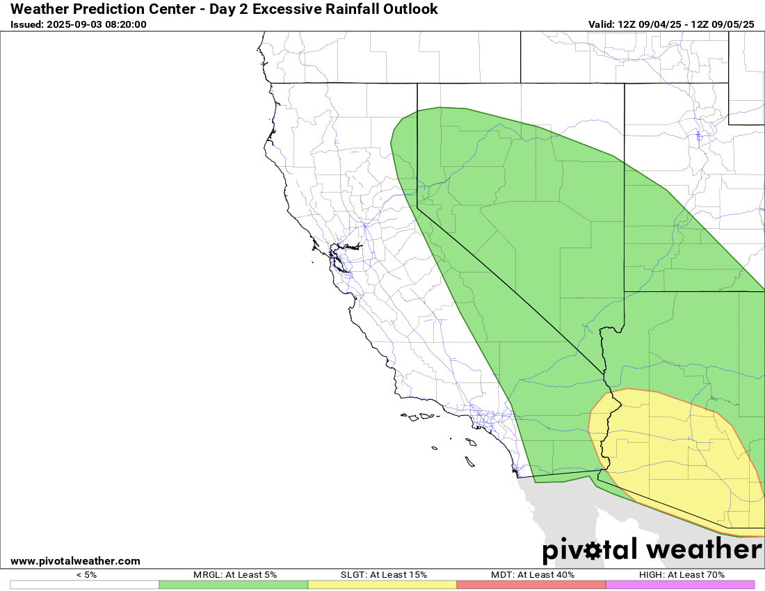
WPC has far southern Arizona in a slight (level 2 of 4) risk of flash flooding today, and that risk expands tomorrow (shown above) to encompass much of the southern Arizona and parts of southeast California.
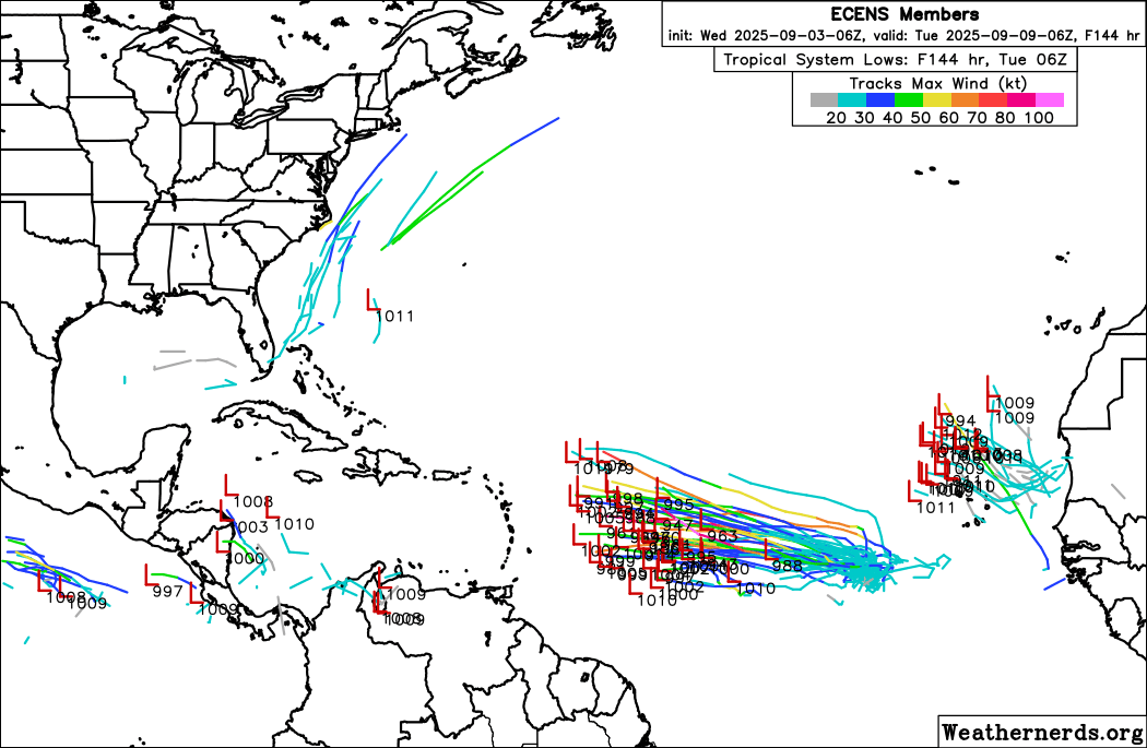
In the Atlantic, NHC continues to show a 70% probability of a tropical cyclone developing out of slowly moving and complex thunderstorm system over the eastern Atlantic. The most recent European ensemble shown above along with the Google DeepMind AI generally support the idea of a slowly developing system moving west for the next week. Today’s post has already gotten pretty long, so rather than going into a deep dive on the overall setup and model differences with this system, I will recommend the tropical focused Substack newsletters of my colleagues Matt Lanza and Michael Lowry who both have detailed discussions today about this system.

Elsewhere in the US today, a cold front will continue to move southeast across the Great Lakes and Midwest, ushering in unseasonably cool, autumn-like air behind it. Along the front, the Storm Prediction Center has a slight (level 2 of 5) risk of severe storms across parts of Kansas and western Missouri. Scattered supercells in this region could produce very large hail, along with some damaging downburst winds and perhaps a tornado or two.

Leave a comment