Warmer weather developing in central and eastern US
Sep 10, 2025

As we approach the middle of September, the weather pattern (for a change) is relatively quiet across the US. With regards to thunderstorm activity, the most focused and widespread activity on Wednesday looks to be in Florida, where a seemingly perpetual stationary front will continue to focus thunderstorm activity. Locally heavy rains could cause some flash flooding, particularly across southern Florida.
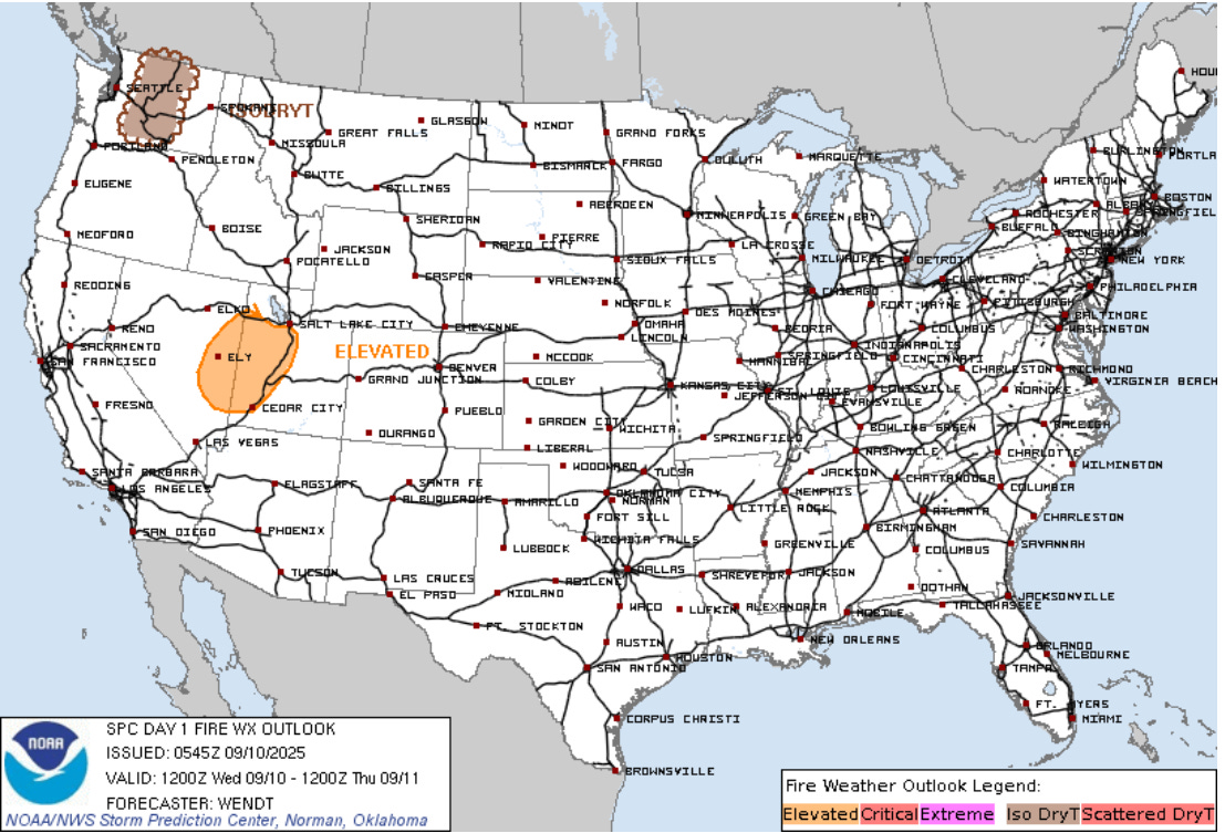
Scattered thunderstorms are also expected across parts of the West, with some much needed rainfall of up to an inch anticipated for parts of Oregon. Farther north, the low level atmosphere will be drier and the Storm Prediction Center has outlooked much of Washington state for potential dry thunderstorm activity that could promote new fire starts. A number of large wildfires continue to burn along the west coast from British Columbia south through California, and the National Interagency Fire Center noted in their daily report this morning that lightning has caused a number of new wildfire starts across Oregon, California, Idaho and Wyoming in the last several days.
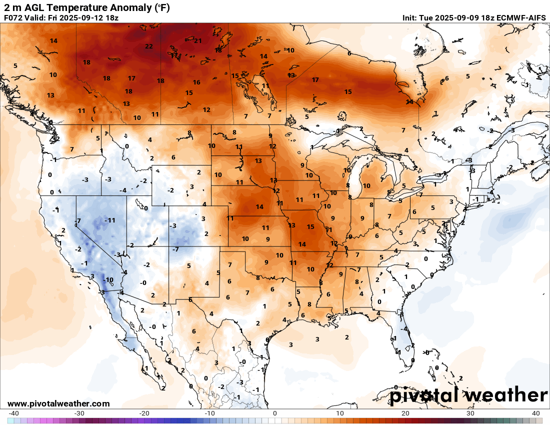
After a cool early September for much of the central and eastern United States, a significant shift to warmer weather is on tap over the next several days. By Friday, afternoon temperatures will be running as much as 15F above normal (forecast temperature anomaly for Friday afternoon shown above) across the central US, with a few record highs possible. Even more anomalous warmth is expected north of the border across much of Canada, particularly in the western prairies.
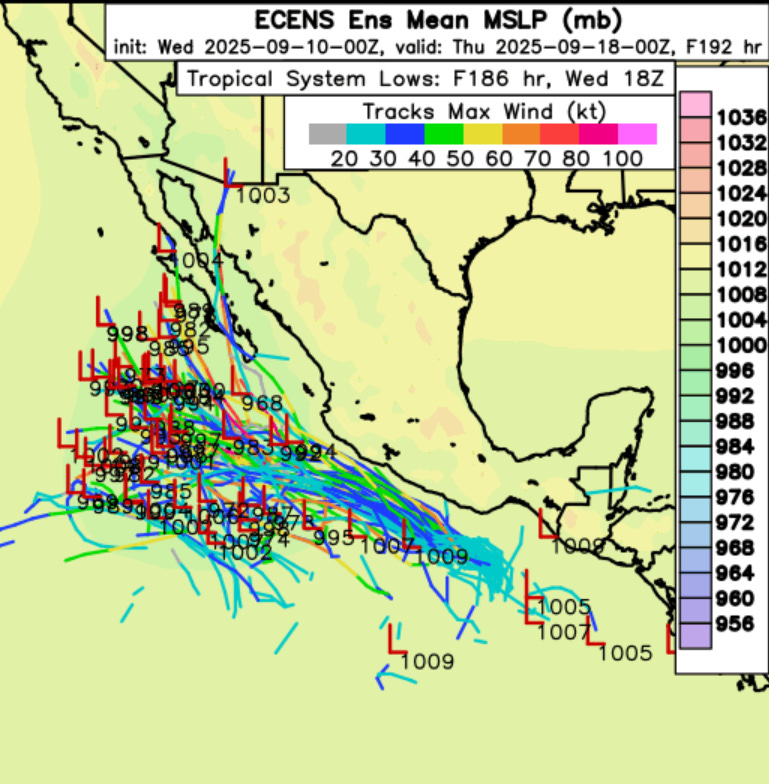
In the tropics, Kiko has weakened to a minimal tropical storm as it passes north of the Hawaiian Islands, though it continues to produce heavy surf and rip currents at beaches in the state. The system we discussed on Monday off the coast of southwest Mexico now has a high chance of tropical cyclone development over the next few days per NHC, and is expected to become a strong tropical storm or hurricane as it moves west-northwest into this weekend as shown in the European ensemble model tracks above. The system could pass close enough to the southern coast of Mexico to cause some rainfall impacts there. We will be monitoring longer term model trends as far as track and any potential impacts to Baja California, although right now most of the model forecasts keep it farther southwest.
In the Atlantic, things are quiet now, but the models overall remain pretty bullish on the idea of the next large tropical wave to emerge off the African coast eventually developing into a tropical cyclone as it moves west-northwest across the Atlantic in the days 5-10 period. It is obviously rather unusual to see the Atlantic tropics so quiet as we are near the climatological peak of the hurricane season. The seasonal forecasting team at Colorado State University issued an excellent discussion on Tuesday explaining and contextualizing the quiet period we have seen since category 5 hurricane Erin a few weeks ago. The full discussion is definitely worth your time, but the gist of their explanation is that instability and moisture have been below normal in the tropical Atlantic due to several atmospheric factors. They also outline why they expect that activity will pick up as we head into the second half of September.
Programming note: I will be attending the Mississippi Book Festival in Jackson this Saturday. From 10:45 am to Noon CT, there will be a panel discussion on the 20th anniversary of Hurricane Katrina featuring former Mississippi governor Haley Barbour, who was governor during Katrina. I am planning to do a live Substack chat of this event for paid Balanced Weather subscribers, internet access permitting. I will be sharing highlights from the panelists as well as my own perspectives from being the NWS meteorologist-in-charge in Jackson at that time. I hope you can join me for this event.

Leave a comment