And the Monday weekly tropical deep dive
Sep 15, 2025
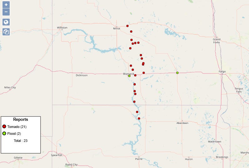
Monday is usually my weekly tropical deep dive post, but before I get into that, I want to recap an event that almost seemed a bit tropical in nature, even though it was focused in North Dakota. A highly unusual for September tornado and flash flood event occurred from northern South Dakota north across central North Dakota on Sunday, with more than 20 reports of tornadoes received by SPC. While some of these individual tornado reports will be combined into longer tornado tracks, there were certainly several tornadoes in the region. Given that North Dakota has only had a total of 27 tornadoes in the month of September ever (dating back to 1950), this is obviously a climatologically rare event.
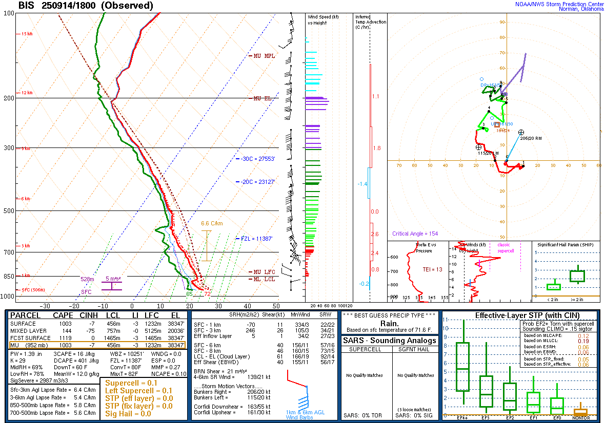
As we have seen so many times this summer all over the country, the most unusual aspect of this event looks to have been the extreme moisture levels. A midday upper air balloon was released from NWS Bismarck yesterday, and it showed a precipitable water value — the amount of water which would result if all the water vapor in the atmosphere above a point was condensed — of 1.39”. Per the Storm Prediction Center’s sounding climatology database, this would be a record for the date, demonstrating the extreme moisture in place across the region.
The other key feature this upper air sounding shows is that the atmosphere is unstable, but not strongly so, with surface based convective available potential energy (CAPE) values around 1000 J/kg. In the Northern Plains during their peak severe weather season in the summer, values of 4000 J/kg or larger are common on severe weather days. One of the measures of atmospheric instability supportive of thunderstorms is the lapse rate, or the change in temperatures with height. At a very basic level, the colder the temperature is aloft above warmer temperatures down low, the more unstable the atmosphere is. On this sounding, the mid level lapse rate between 3 and 6 km was only 5.4C per kilometer, indicative of very weak instability aloft in the atmosphere.
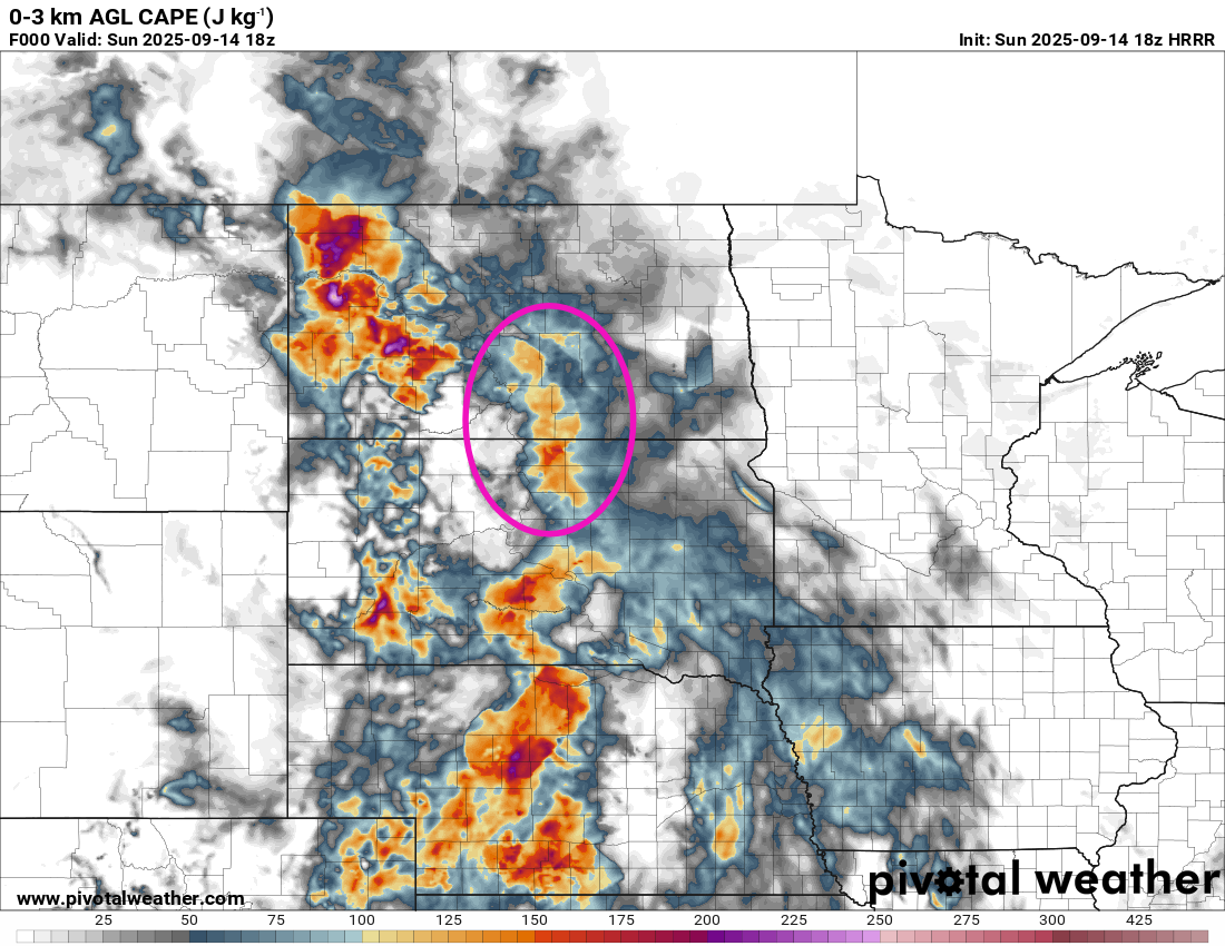
However, if we look at 0-3 km CAPE — a parameter which shows how much instability is focused in the lower levels of the atmosphere up to 3 km AGL — there is an area of greater than 100 J/kg in south central North Dakota at the same time of the Bismarck sounding. For the 0-3 km CAPE, this is a rather large value.
The area highlighted in the purple ellipse above was also near a northward moving intensifying low pressure system and warm front. This resulted in strong low level wind shear as winds were east-southeast near the surface but quickly became strong from the southwest a few kilometers up. The strong wind shear combined with sufficient low level instability for tornadic storms is more akin to the front right quadrant of a landfalling tropical cyclone, but outside of tropical cyclones is a setup more often seen in the South in the winter months. However, the unusual levels of moisture — along with the high PW values, surface dewpoint values were near 70F — and intensifying surface low and warm front put central North Dakota in this type of a setup on Sunday afternoon.
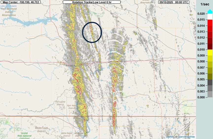
The Multi-radar Multi-sensor (MRMS) system’s rotation tracks product shows that a few north-south bands of storms with strong low level rotation moved across North Dakota during the afternoon, which produced the tornadoes.
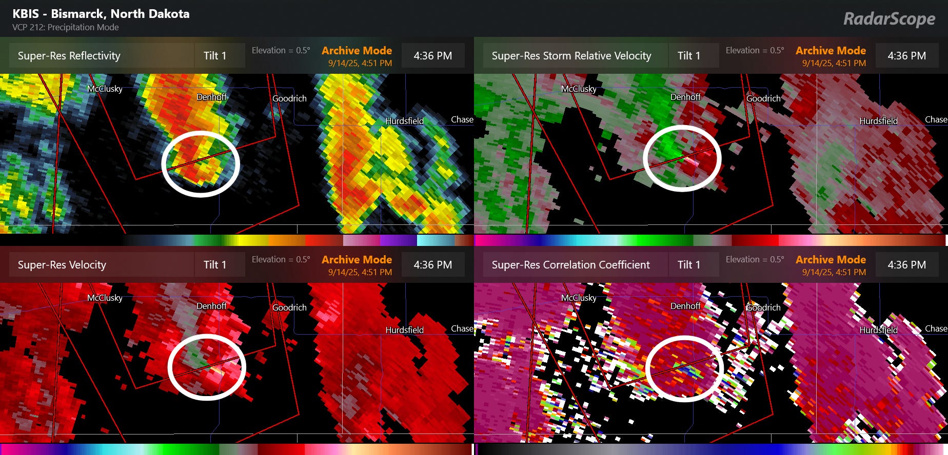
To give an example of what these supercells look like on radar, I have focused on one from the area circled in black northeast of Bismarck on the rotation tracks product. Even though the supercell thunderstorm is rather small and has a storm top of around 35,000 ft AGL — relatively modest for a severe storm — it has strong low level rotation — the green and red next to each other circled in the upper right panel. In the lower right, the correlation coefficient — a radar product showing the size and shape of the particles being detected — shows an area of very low values within the white circle. This is a tornadic debris signature, i.e., where the tornado is lofting debris and it is being detected by the radar. Damage was in fact reported in this area.
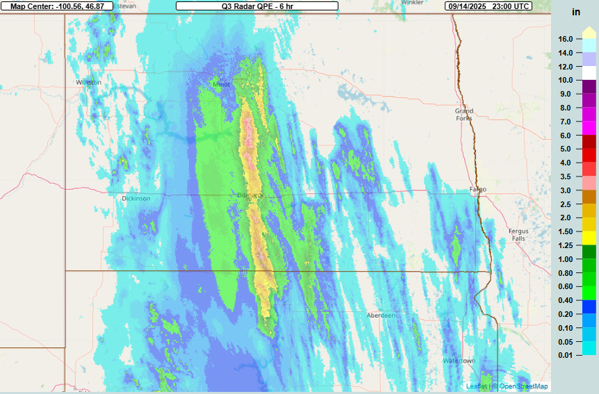
With such unusual moisture in the atmosphere, it is of course not surprising that there was extreme rainfall as well. The MRMS 6 hourly rainfall product ending at 6 pm CT showed a band of up to 4” of rain across central North Dakota including the Bismarck area. Bismarck Municipal Airport picked up 1.93” of rain in an hour between 2:50 and 3:50 pm, and had a total for the day of 2.44”, the fourth highest daily September rainfall on record (records back to 1874) and more than the entire September monthly normal value of 1.72”.
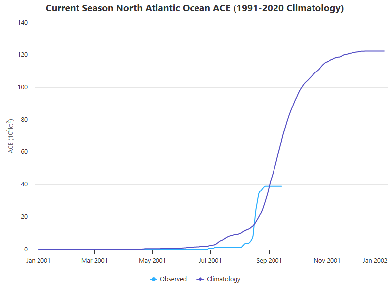
Turning now to the tropics, last week we managed to go the entire week of what is pretty much the peak of hurricane season without any system in the Atlantic. The Colorado State University real-time accumulated cyclone energy (ACE) tracker shows that with no activity during the peak of the season, we are now more significantly falling behind “normal” values of tropical activity.
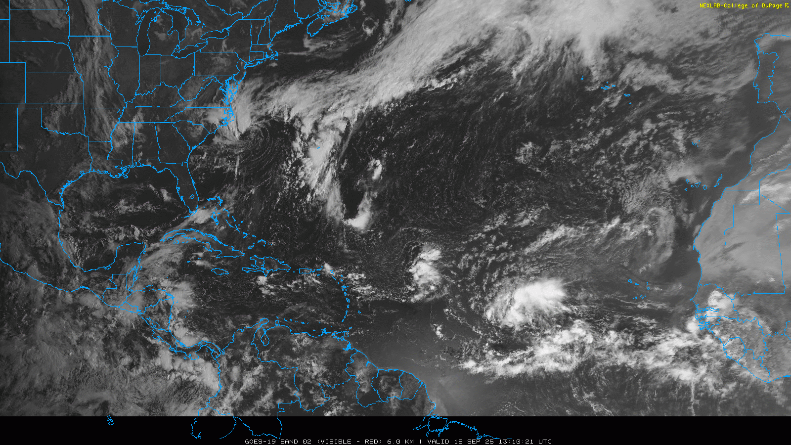
It does seem likely that we will see our next system in the Atlantic later this week. There is a large tropical wave in the central Atlantic — you can see the spin and thunderstorms located in the middle of the ocean due east of the Caribbean. The National Hurricane Center (NHC) has designated this tropical disturbance Invest 92L and has forecast an 80% likelihood of development into a tropical cyclone this week.
The system has been gradually increasing in organization the last 24 hours and looks to be moving into a more favorable environment. The models are rather bullish on it, particularly later this week and into the weekend when a number of models develop it into a hurricane.
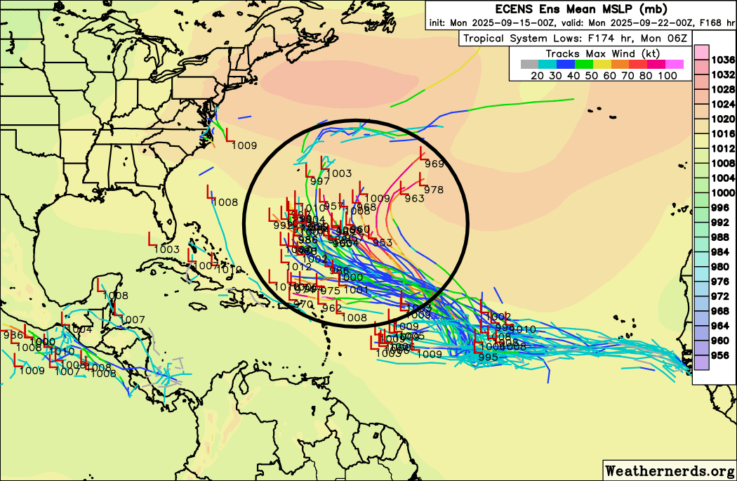
As far as track, both the Google DeepMind AI and European ensemble generally show a west-northwest track for the next week to a position somewhere north/northeast of the eastern Caribbean islands. However, as you can see in the circled area above, there is a wide difference in positions within the European ensemble model forecasts a week from now, varying from just north of Puerto Rico to well out to sea in the central Atlantic. A big reason for this forecast spread is rather large differences in exactly where and how soon development of an organized system will occur. Regardless, right now the probability of any significant land interaction with 92L seems low — but of course we will watch it closely.
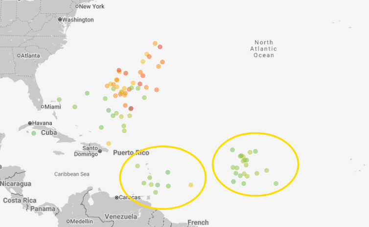
There look to be two other trailing waves with possible development — shown in the yellow circles on the 7 day forecast from the Google DeepMind AI forecast system above. Right now the probabilities of development seem relatively muted but we will watch. The models are also occasionally hinting at the possibility of development closer to home in the western Caribbean in the day 8-14 period, and we are getting into the time of year when such development is more common. However, as of now there is nothing in particular to focus on.
I also want to mention the well organized low pressure system you can see in the satellite loop off the North Carolina coast. That system is a non-tropical low and right now is under strong upper level wind shear. However, that wind shear is forecast to gradually weaken over the next 24 hours and considering how well developed the low level circulation is, I don’t think it is completely impossible that enough thunderstorm activity could develop with this low for it to become at least a subtropical system. Regardless, it will mainly be a rainmaker along with some strong winds along the coast.
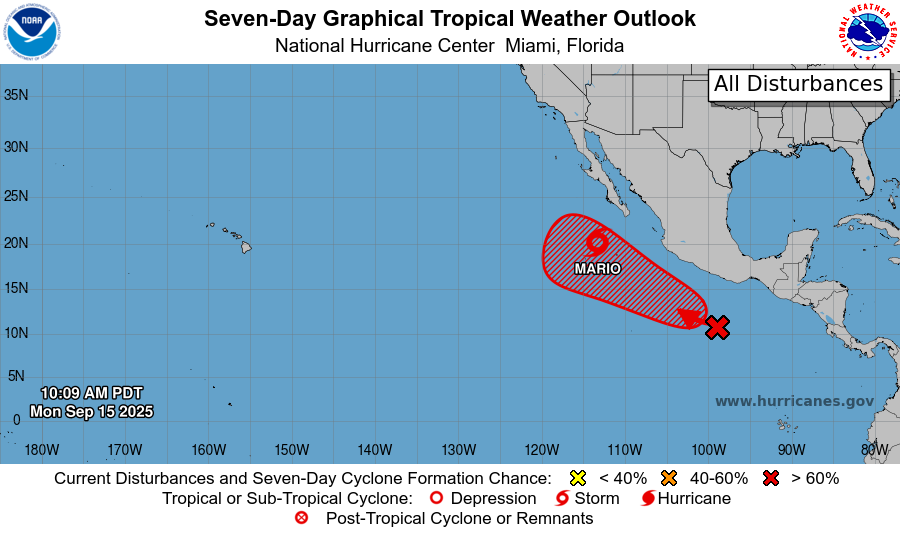
Finally, in the Pacific, Mario is a 60 mph tropical storm in southwest of the southern tip of Baja. It is forecast to gradually weaken over the next couple of days as it moves over colder water. However, an upper level weather disturbance off the California coast will pull remnant moisture from Mario up into California later this week, potentially spurring thunderstorm development which could be a fire weather concern. I will have more on this in tomorrow’s newsletter. Another system will likely develop behind Mario later this week as shown on the NHC outlook — that system should be far enough off the Mexican coast to not be much threat for them in the next several days.

Leave a comment