Tropics look to be entering an active period from western Pacific to the Atlantic
Sep 19, 2025
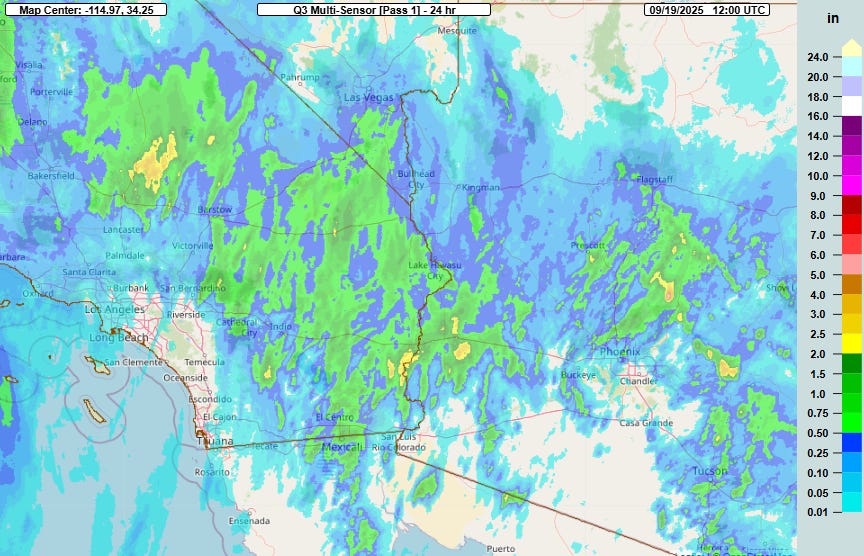
Happy Friday! As anticipated, an upper level low and moisture from the remnants of Tropical Storm Mario brought thunderstorms with heavy rainfall to the Southwest on Thursday. While the rainfall totals shown on this MRMS 24 hour rainfall map from 7 am CT this morning may not seem impressive, for the desert Southwest in September they are, particularly when you consider that much of this rain fell in a short duration from thunderstorms.
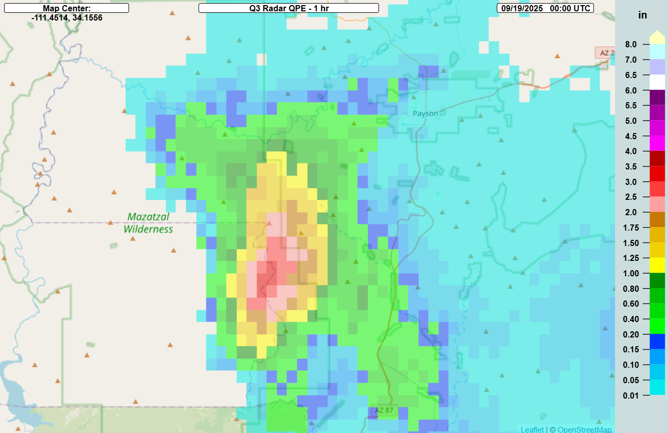
An illustrative example occurred southwest of Payson, AZ with MRMS estimating localized rainfall of over 3 inches of rainfall in an hour ending at 7 pm CT.
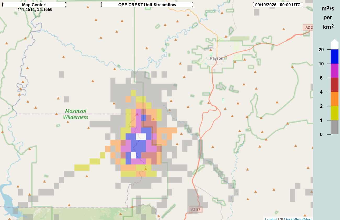
The MRMS FLASH unit streamflow hydrologic product shows the kind of runoff and flash flooding that can be generated in the Southwest from such rainfall, as the values were maxed out. Luckily, this was over a relatively rural area, but some significant flash flooding impacts did occur, particularly over San Bernardino County in southern California as described in this CNN article.

The risk of flash flooding looks to be somewhat less today as the moisture shifts farther east, but there is still a marginal (level 1 of 4) risk of excessive rainfall across parts of the Southwest into the central Sierra Nevada.
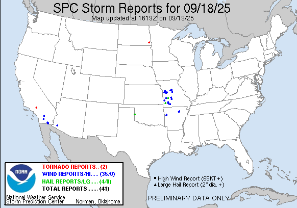
The thunderstorms in the Southwest also produced some damaging wind gusts and a brief tornado. A complex of severe storms also produced a number of wind and hail reports across western Missouri Thursday afternoon.

Overall, a relatively non-descript weather pattern is expected this weekend with showers and storms possible over much of the country, but not much in the way of organized hazardous weather anticipated. Temperatures will be near to above normal for much of the country, except the Northeast where cooler than normal conditions are expected and some frost advisories and freeze warnings are in effect along the Canadian border.
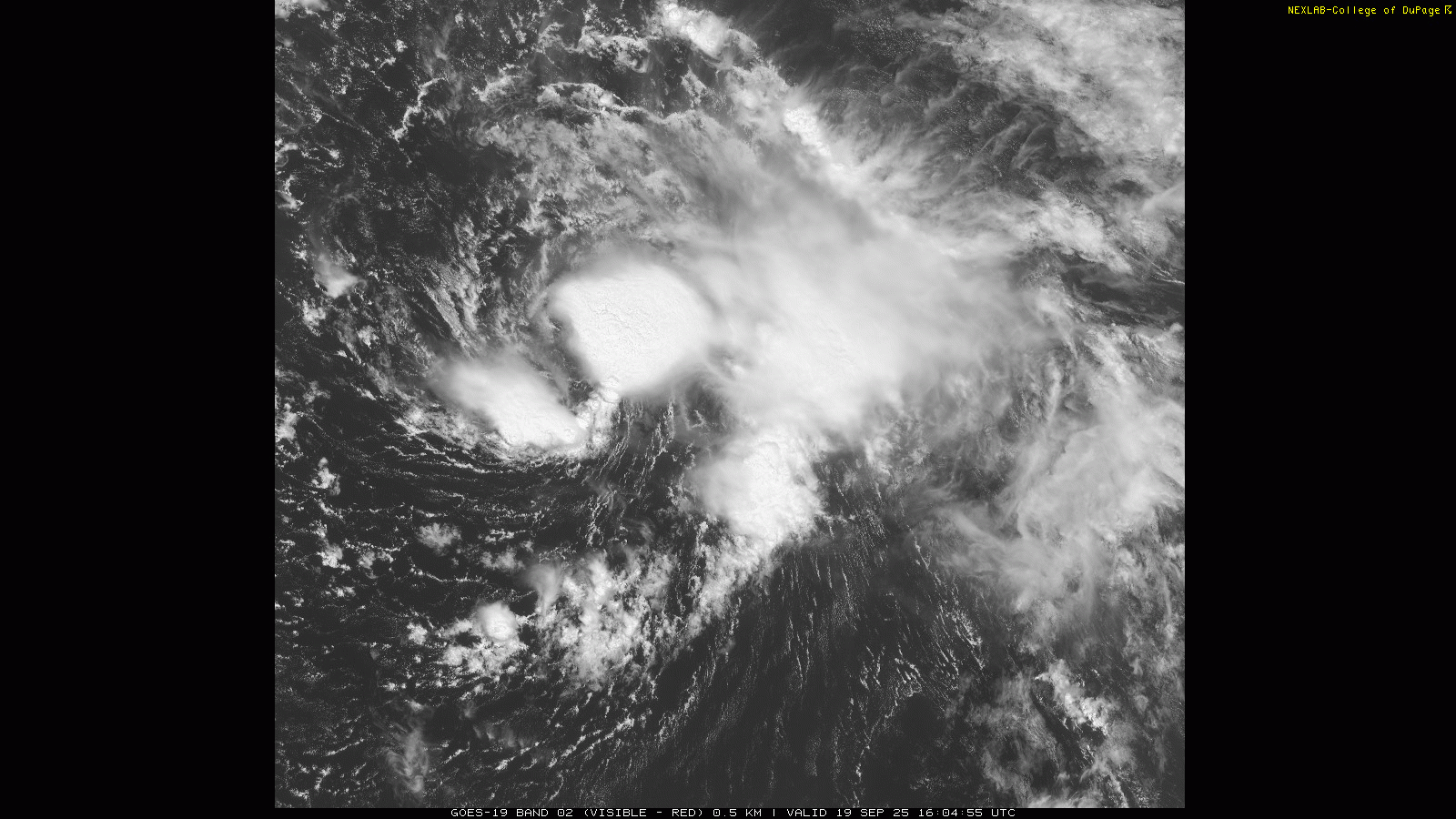
Turning to the tropics, morning satellite imagery shows that Tropical Storm Gabrielle appears to be entering the more supportive atmospheric environment the models have been anticipating. Thunderstorms have been developing and maintaining themselves the last several hours near the center of circulation, implying that the upper level wind shear that has been affecting the system is likely abating.
Gabrielle will be passing over plenty warm waters to support significant strengthening assuming the overall environment is more favorable as forecast, and NHC is forecasting it to intensify to a category 2 hurricane as it passes east of Bermuda. Some of the more bullish models show it becoming a major hurricane which is certainly possible, especially given the recent signs of increasing organization. While the models are in good agreement that Gabrielle will pass east of Bermuda, depending on the size and intensity of the storm at its closest pass it could still cause some impacts to the island, so people with interests in Bermuda should still be monitoring Gabrielle closely.
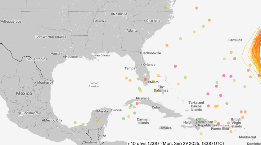
Beyond Gabrielle, the AI based models — both the Google DeepMind system (10 day forecast shown above) and the European AI based models — continue to become increasingly bullish on the idea of the potential for a significant system forming somewhere in the western Caribbean or southwestern Atlantic in about 10 days. Some of that is likely just a reflection of the fact that as we get later into September and October the climatology of tropical cyclone formation becomes more favorable in the western Caribbean, so it makes sense that AI based models would become “hotter” as we get more into that time period. However, there are also signs that the overall weather pattern could become more favorable for “closer to home” development as the model ensembles suggest the development of an upper level trough of low pressure over the eastern United States late next week.
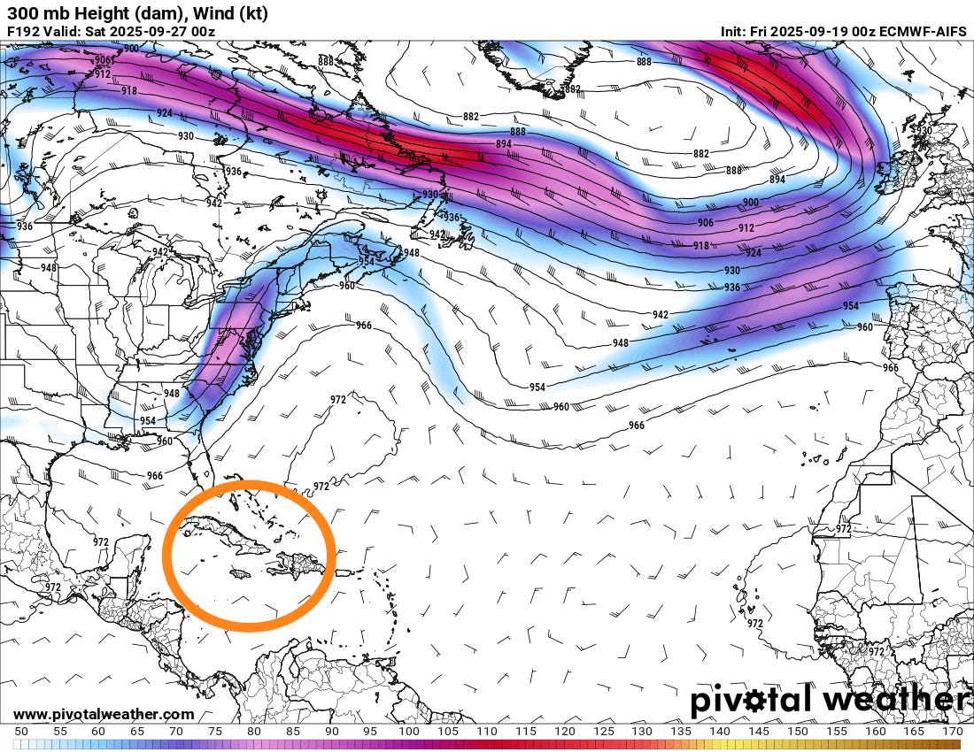
Assuming such a trough develops, this should result in an area to the south and southeast of the trough with light upper level winds and stronger upward motion in the atmosphere that would be favorable for tropical development (circled in orange). The map I have shown above for illustration is the 300 millibar (about 30,000 ft AGL) day 8 forecast map from the European AI model — obviously, each model has a somewhat different location and strength for the upper level trough, resulting in a different location and level of favorability for a possible tropical cyclone formation area. Bottom line — this is clearly just something to keep an eye on at this point, but as I have talked about in other posts, this sort of “home grown” tropical cyclone scenario is the most likely way the US sees a significant tropical impact the rest of the hurricane season.
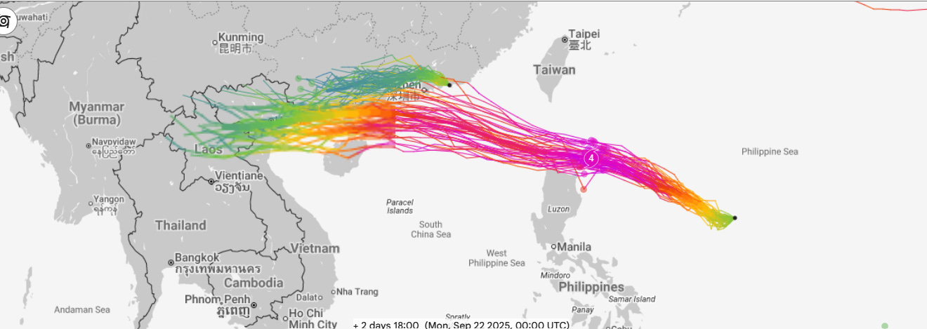
The models — and again, especially the AI based models — suggest a very busy period of tropical activity for much of the northern hemisphere the next two weeks, including the western Pacific which has also been unusually quiet this season. In the short term, Tropical Storm Ragasa looks likely to become a very powerful typhoon as it passes just north of the Philippines in a few days. Depending on the exact track and intensity, it could cause significant impacts to northern Luzon, and then will be a potential risk to China and Hong Kong next week.

Leave a comment