And a deep dive into the Atlantic tropics with increasing threats for Bermuda and possibly the Southeast US
Sep 25, 2025
So much weather to talk about today, but I want to start off with follow-up about the news last night broken by Politico that the Office of Personnel Management (OPM) is directing federal agencies to develop and pursue plans for large scale permanent reductions-in-force as part of its planning for a federal government shutdown. In an update to their article, Politico published the text of the actual “memo”. To be clear, this is not an official OPM shutdown guidance memo published on the OPM website, rather it looks to be an email that was sent to department deputy secretaries and other bureau and agency heads. Therefore, it also has a lot of political and side commentary. To me, this is the key section with regard to potential federal layoffs as part of a shutdown:
With respect to those Federal programs whose funding would lapse and which are otherwise unfunded, such programs are no longer statutorily required to be carried out. Therefore, consistent with applicable law, including the requirements of 5 C.F.R. part 351, agencies are directed to use this opportunity to consider Reduction in Force (RIF) notices for all employees in programs, projects, or activities (PPAs) that satisfy all three of the following conditions: (1) discretionary funding lapses on October 1, 2025; (2) another source of funding, such as H.R. 1 (Public Law 119-21) is not currently available; and (3) the PPA is not consistent with the President’s priorities. RIF notices will be in addition to any furlough notices provided due to the lapse in appropriation. RIF notices should be issued to all employees working on the relevant PPA, regardless of whether the employee is excepted or furloughed during the lapse in appropriations.
In the event of a government shutdown, each federal employee who is furloughed receives a formal memo from their agency stating that they are on furlough and what they can and cannot do while in furlough status. After wading through all the bureaucratese here, I believe the gist of the text above is that OPM is directing the agencies to consider having plans in place to also issue permanent reduction-in-force termination notices in addition to the furlough memos to employees if their work is not funded by another source of funding and is not a presidential priority. HR-1 is the reconciliation and rescission bill that was passed and signed into law in July; it provided additional appropriations for a number of the administration’s military and law enforcement priorities, but from what I can see, little or none of that would apply to federal science agencies like NOAA or NASA.
The memo goes on to say that “once fiscal year 2026 appropriations are enacted, agencies should revise their RIFs as needed to retain the minimal number of employees necessary to carry out statutory functions. Any proposed RIF plan must be submitted to OMB.” My interpretation of this is that whenever formal appropriation bills are passed by Congress and signed into law to provide full FY2026 funding, the agencies would be able to decide which employees were still “needed” and could rescind their RIF notices.
Obviously, these RIF plans could affect a number of federal science entities — and FEMA — whose budgets are targeted for deep cuts or even elimination in the President’s FY2026 budget. I do think that the fact that the agencies were directed to “consider” RIF implementation is a key distinction, and seeing how proactively individual departments and agencies pursue RIF planning as part of a shutdown will provide some clues as to how aggressively the administration plans to pursue some of the cuts outlined in the OMB budget. Again, I am assuming that operational forecast, warning and disaster response from entities such as the NWS and FEMA would continue to operate as usual during a furlough given past precedent — but there is nothing in the e-mail memo that specifically states that.
Even if a shutdown is avoided, it seems clear that under a continuing resolution those entities targeted for cuts under OMB’s budget plan will be operating under very tight budget constraints as the administration will have pretty much full control over their budget execution until agency specific budgets are passed by Congress and signed into law. As I talked about in my post last night, this will be another period of time where the administration could push RIF and other reorganization actions to try to make their vision for agencies a fait accompli before Congress can pass appropriations.
A number of people much smarter than me about law have questioned on social media the legality of these various OMB plans — and aspects of them may very well not be legal. However, as we have already seen over the last several months, this would likely only mean that legal battles will result as the plans are executed, not that the administration would stop trying to move forward.
Finally, I want to stress that all of this is obviously a very complex situation that is changing rapidly and has a lot of uncertainties — I am offering my best interpretation of it based on my own experience because I believe we are in a critical time for the future of weather science and disaster management in this nation, and that people need to be aware of what is happening and the potential ramifications. I will try to keep updating as we learn more and as my perspective evolves.
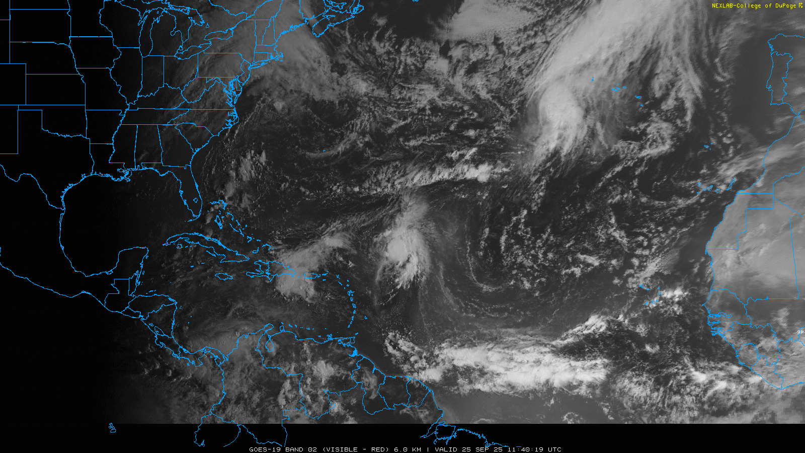
Turning to weather, we will start in the busy Atlantic tropics where our three systems of focus are pretty evident: Hurricane Gabrielle, rapidly moving toward the Azores and eventually the Iberian Peninsula; strengthening Tropical Storm Humberto northeast of the eastern Caribbean islands; and Invest 94L near Hispaniola.
As expected, Gabrielle has weakened due to wind shear and cooler waters, but is still a minimal hurricane. In the satellite imagery above, you can see the large cloud mass of an upper level trough of low pressure approaching the hurricane from the northwest, and this will help keep the system as a minimal hurricane or high end tropical storm as it moves across the Azores over the next day. Significant wind, surge and rain impacts are expected in those islands and a hurricane warning remains in effect. Gabrielle should weaken and become post-tropical as it moves toward Iberia, but will still cause some wind and rain impacts there this weekend.
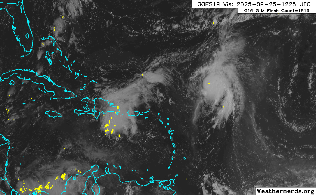
That brings us to Tropical Storm Humberto and the gradually organizing disturbance 94L, which look destined to bring us a complex meteorological and forecast scenario in the coming days. Humberto is still under a bit of westerly upper level wind shear — partially from upper level winds flowing out of 94L — but it is getting better organized and now has maximum sustained winds of 50 mph. 94L is also getting better organized, although the low level circulation associated with it looks to be on the northern edge of the mass of thunderstorms, somewhere near or just offshore north of the Dominican Republic. Squalls of heavy rain and gusty winds will continue over Hispaniola and Puerto Rico today.
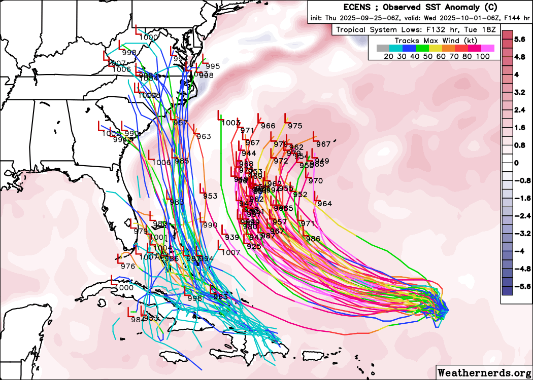
The models (most recent European ensemble members shown above) are pretty well unanimous in showing that both of these systems will end up in environments quite favorable for intensification the next several days. Nearly all of the model solutions show Humberto becoming a major hurricane this weekend as it moves relatively slowly northwest to the south of Bermuda, while a consensus model forecast suggests 94L becoming a strong tropical storm or hurricane as it moves northwest through the Bahamas.
There are some immediate caveats here though. First, the proximity of the two systems means that there will likely be interactions between the two that will affect both the track and intensity of both systems in ways that are difficult for the models (or humans) to anticipate. Secondly, the main circulation with 94L has still yet to become well defined, and until that happens, significant shifts to the forecast for 94L could occur due to shifts in where the system gets organized.
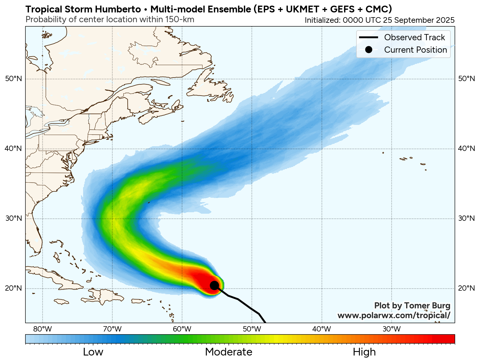
With those caveats in mind, the forecast for Humberto still seems the more straightforward. Both the physical and AI models pretty well agree on the idea of the system moving northwest and then eventually recurving more northeast as it rotates around Bermuda. Assuming the hurricane is as large and intense as anticipated, this forecast track would pose a serious threat to Bermuda, and obviously people with interests there should be monitoring forecasts closely.
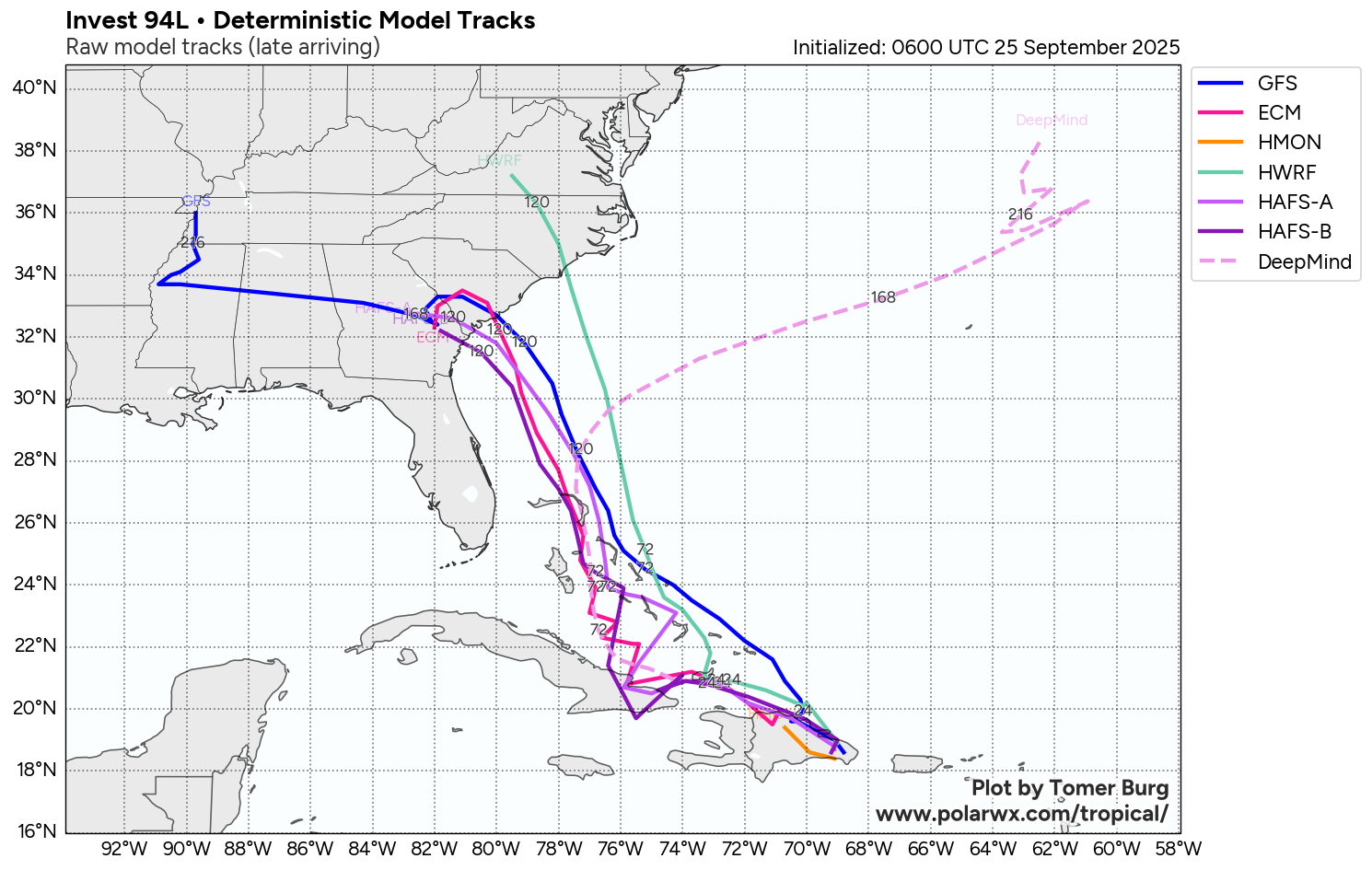
The longer term endgame for 94L is much more uncertain. As you can see in this map above, most of the traditional physical based models generally track 94L toward coast — while the AI models (Google DeepMind shown in the graphic) on average show a turn more to the northeast to follow behind Gabrielle toward Bermuda. However, it needs to be stressed that the Google Deep Mind (GDM) is showing a lot more dispersion and run-to-run model differences than I have seen in it so far this year, as it does have a number of members on each model run showing a solution more like the physical models. In fact, the 1800 UTC run of the GDM yesterday had about 50% showing a track closer to or over the Carolinas, although more recent runs have lesser numbers with that scenario.
From a big picture meteorological perspective. the steering flow of 94L will be incredibly complex, as the upper level trough of low pressure along the East Coast will be gradually weakening and pulling out — but leaving behind a weak upper level low pressure center — as well as likely track influences due to Humberto. At a very basic level, it seems to me that meteorologically the more quickly 94L develops and the faster it moves and slower Humberto moves, the more likely it is to “feel” primarily the influence of the upper level trough and move toward the Carolinas. Conversely, the slower 94L develops and moves and the faster/stronger Humberto is, the more likely it becomes that 94L will eventually follow Humberto to the northeast. Again, the bottom line is that the East Coast, Florida, Bahamas and Cuba all need to be watching 94L closely.

In the US today, scattered to numerous showers and storms will continue across the east ahead of the slow moving storm system associated with upper level trough of low pressure we talked about above. Above normal moisture could fuel heavy downpours with afternoon and evening storms over Arizona, where the Weather Prediction Center has outlooked a slight (level 2 of 4) risk of flash flooding. Critical fire conditions are anticipated in interior parts of Washington and northern Oregon.

Leave a comment