Three of USGS Climate Adaptation Science Centers threatened by lack of funding; threat of tropical impacts to the Southeast continues to grow
Sep 26, 2025
Before I get into the busy Atlantic tropics, I want to share some climate related news that was announced yesterday. The South Central Climate Adaptation Science Center (CASC) which is based at the University of Oklahoma, announced yesterday that it will transition to minimal operations effective October 1st. This is not related to a potential government shutdown, but rather because of issues with receiving its grant funding from the US Department of the Interior. From the South Central CASC’s website:
Beginning October 1, 2025, the South Central Climate Adaptation Science Center (CASC) will fully transition to minimal operations until such time when the U.S. Department of the Interior (DOI) approves our FY25 funding. Without our base funding, we will be unable to participate or lead any new projects, programs, or services. Existing efforts may also be paused or reduced in scope until we receive our funding, which is currently being withheld by DOI and the Office of Management and Budget (OMB) for our CASC and the two other regional CASCs. Although the FY26 House and Senate budget markups emphasize the bipartisan and bicameral support for the CASC network going forward, our full-year funding is unavailable for CASC students, staff, and faculty; engagement activities with Tribes and resource managers; travel and workshops; communication products; and administration. Projects funded through other sources (e.g., BIA, NSF, NOAA) will continue.
The Climate Adaptation Science Centers program is led by DOI’s United States Geological Survey (USGS), and “is a partnership-driven program that teams scientists with natural resource managers and communities to help fish, wildlife, water, land, and people adapt to a changing climate.” Each of the nine regional climate centers around the country is led by a university in the region, and is focused on using science to perform research and develop data sets and tools “to help natural resource managers protect natural places and local communities in a changing climate” in their specific region. Along with the South Central CASC, the other two regional climate centers that are waiting for their funding are the Pacific Islands CASC based at the University of Hawai’i and the Northeast CASC based at the University of Massachusetts-Amherst.
When I moved from the National Weather Service to the National Severe Storms Lab and NOAA Research back in 2015, one of the exciting opportunities I received was to be able to work with a community based research partnerships similar to the USGS CASCs. In particular, I was fortunate to help kickstart along with some of my colleagues a VORTEX-USA supported partnership with the Mississippi-Alabama Sea Grant Consortium (MASGC). This project takes VORTEX-USA research results about severe weather and uses them to help communities and individuals in the Southeast be better prepared for severe weather, as well to obtain feedback to help guide future VORTEX-USA research. Being involved with that effort was one of the highlights of my career, and I have become convinced that these type of partnerships between scientists, education specialists and communities are key to helping our society build resilience to disasters related to natural hazards.
While luckily the VORTEX-USA/MASGC project was recently funded, I am very concerned for the future of other work like the USGS CASCs, especially because the CASC program and many others have “climate change” in their mission. In my opinion, the loss of these programs would be very unfortunate, because regardless of one’s political viewpoint, the reality is that climate change is occurring and we as a society need to continue to adapt to it — and of course, the natural disasters these projects mostly focus on such as hurricanes, tornadoes and tsunamis will continue to happen regardless of climate change. Hence, reducing or eliminating the community focused programs to use science to help society be more prepared and resilient to these events seems incredibly counterproductive. As noted in the South Central CASC’s statement about their situation, this is yet another example where all of the signs from both sides of the aisle in Congress suggest much stronger support for this work in the legislative branch versus the administration, so this is yet another aspect of federal science to closely watch whether Congress or the Trump Administration end up being the dominant influence.
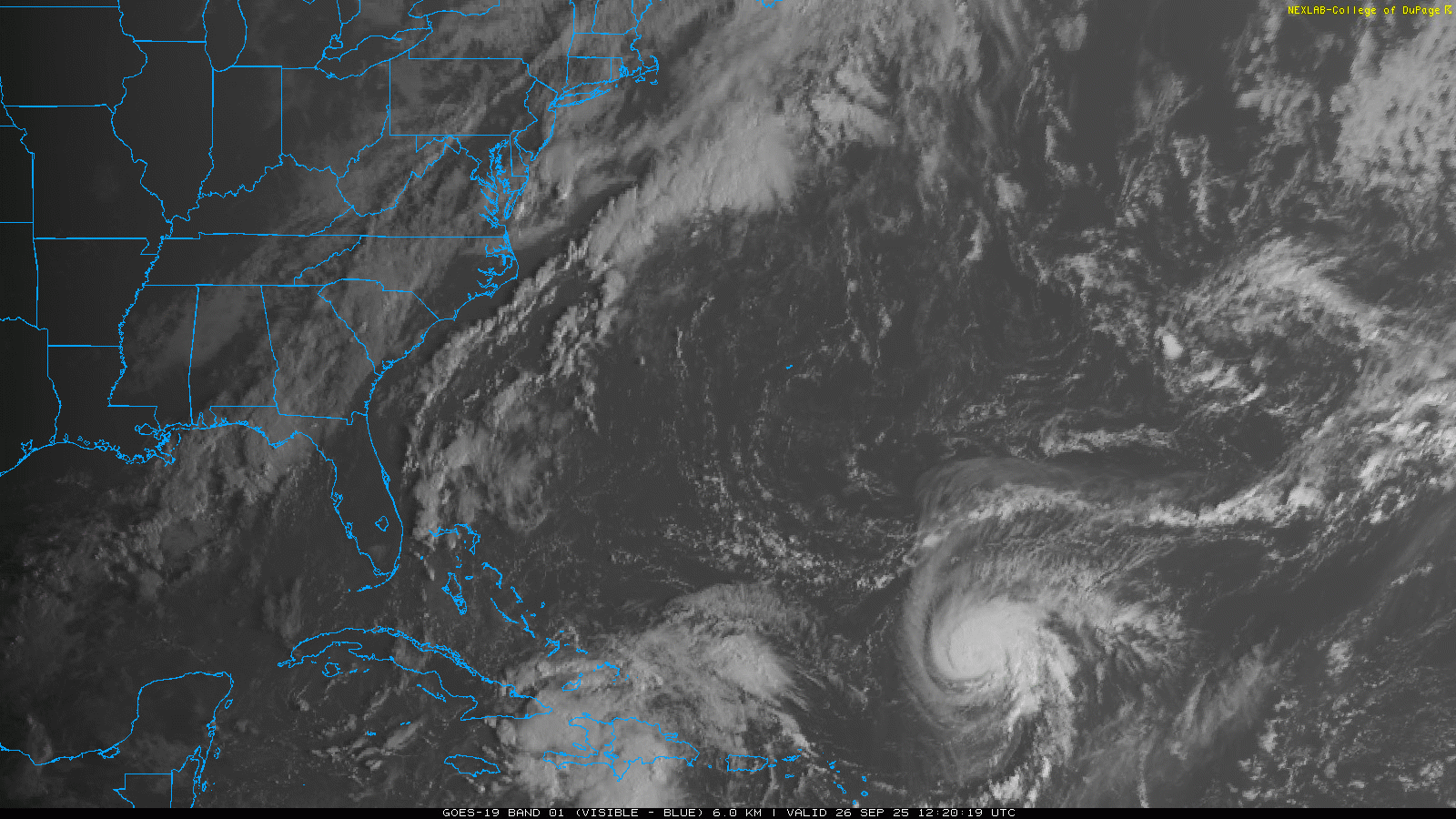
Turning now to the Atlantic tropics, we have intensifying Hurricane Humberto northeast of Puerto Rico, and organizing Invest 94L which looks to be taking shape in the vicinity of the Windward Passage between Cuba and Haiti. (As a reminder and especially to new subscribers, I have a Hurricane Information Primer here where you can find out more about hurricane forecasting and terms such as “Invests.”)
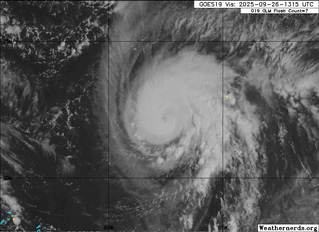
There is still a lot of uncertainty about the forecast scenario for the Southeast US and Atlantic tropics — but the evolution and forecast of Humberto continues to be the “clearer” aspect of it, so we will start there. Humberto looks to be rapidly intensifying over the last 12-18 hours. The eye has become defined in both visible and infrared satellite imagery, and is surrounded by strong thunderstorms. Maximum sustained winds on the 10 am CT advisory from the National Hurricane Center increased to 90 mph, and Humberto looks to be well on its way to becoming the Atlantic’s third major hurricane of the season.
(Interesting side note: the Atlantic has only had 3 hurricanes so far this season, but assuming Humberto does make category 3 intensity, all three will have been major (Erin a category 5, Gabrielle a category 4). The Atlantic is clearly hitting for power instead of average this year.)
While there could be some hiccups from interactions with Invest 94L and eventually from internal structural changes within Humberto, overall the track and intensity scenario with the system is relatively straightforward. Humberto will be moving northwest through a very favorable environment the next few days and should be a major — likely at least category 4 on the Saffir-Simpson Hurricane Wind Scale — hurricane through the weekend. By early next, it will begin to turn more northeast on the west side of a large upper level high pressure area and conditions will become less favorable, so some weakening is anticipated.
Given the anticipated size and intensity of Humberto — and the fact that the eye of the hurricane looks to pass west of Bermuda meaning the island will be on the bad “dirty” east side of the storm — it is looking increasingly likely that Bermuda could have impacts from this hurricane. Obviously, the farther the center tracks toward the right side of the cone as shown in the forecast above, the more significant the impacts are likely to be.
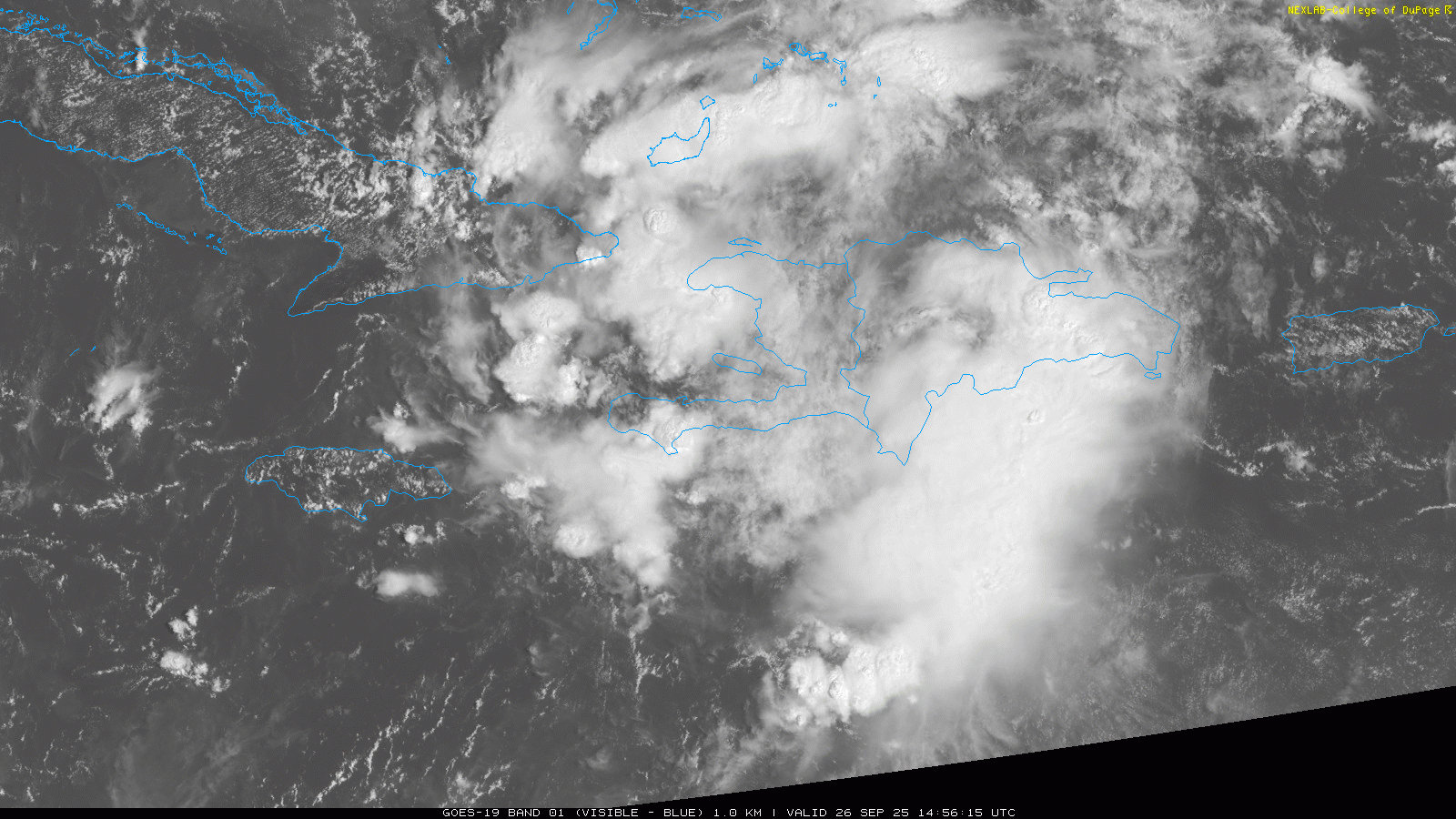
Moving west to Invest 94L — as expected, this system has had a tough time getting better organized as it moved across the Greater Antilles, but it has stayed well defined with plenty of thunderstorm activity. Now that it is getting farther northwest, there are recent signs in visible satellite imagery that a better defined low level circulation could be forming between the Inaguas Islands of the Bahamas and the eastern tip of Cuba. This is likely the start of an increasing organization trend that should lead to development of a tropical depression in the next 24 hours.
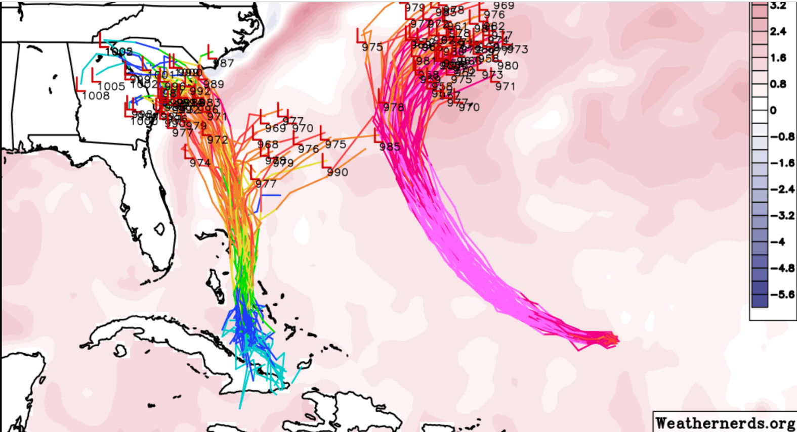
While there is still a tremendous amount of uncertainty with many scenarios possible, overall the trend in the last 24 hours seem to be toward increasing likelihood of impacts to parts of the Southeast from 94L. The Google Deep Mind (GDM) AI model system has been the skilled model that has shown the most members turning what develops from 94L — which is likely to be at least a strong tropical storm — east to follow into the “weakness” left behind Humberto. However, with time it has been trending toward showing less forecast members with this scenario, and in the most recent run shown above (valid Tuesday night), only about 10 members show that scenario while all the rest show a track toward or over the Carolinas, which is similar to most of the other models.
Having said that, a turn more to the east sometime early next week is certainly still a viable alternative. In the GDM forecast valid Sunday night, there is still a tremendous “along track” spread in the forecast location of 94L, from east northeast of Cape Canaveral to still back over the central Bahamas. What I described yesterday still seems accurate to me — the more quickly 94L moves north and the slower Humberto moves northwest, the more likely an eventual track toward the Carolinas becomes.
It is important to recognize that even if the track toward the Carolinas does end up materializing, the steering currents will be weakening, and the system could stall somewhere in the region, and whether that is over land, near the coast, or offshore, would have huge implications on the weather impacts. The 10 day GDM forecast shows all sorts of possible scenarios, with even a handful of members eventually taking the system north along the East Coast. The bottom line at this point is there is still a lot of uncertainty — but people along the East Coast should continue to monitor, and the potential for direct impacts from what comes of 94L does look to be increasing for the Southeast US coastal region.
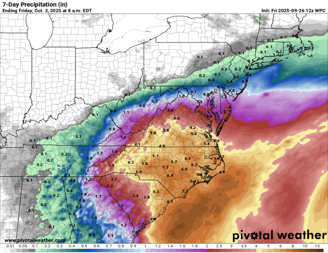
Regardless of the direct impacts from 94L, what seems increasingly clear is that the threat of heavy rainfall and flooding over the next several days is increasing for the Carolinas, and especially the Piedmont and coastal regions. Tropical moisture will be pulled into this area ahead on the north and northwest sides of the two tropical systems, and with atmospheric forcing from the upper level trough of low pressure we have been discussing over the region, waves of thunderstorms with heavy rainfall are anticipated through Monday even before any direct impacts occur from the tropical system. This will obviously be a situation that people in the region should be watching closely the next few days.

For today, thunderstorm activity is expected to be more focused in the central Appalachian region, where a slight (level 2 of 4) risk of flash flooding is in place. An upper level weather disturbance and tropical moisture are expected to produce thunderstorms across parts of southern Arizona and southwest New Mexico, where slight risks of both flash flooding and severe thunderstorms are in place.

Leave a comment