Slightly more forecast clarity this morning, but still many potential outcomes; Impressive Humberto a category 4 hurricane with threat to Bermuda. And rain in Phoenix!!
Sep 27, 2025
There is SO much weather to talk about today, but before I get into that, I unfortunately feel compelled to again talk about what is going on with the federal government as far as NOAA and a potential government shutdown. The Washington Post this morning published what I think is an excellent article summarizing the state of the National Weather Service as we get into the fall. I talked about what I have been hearing and my perspective about the state of NOAA/NWS in a post on Thursday, and this article confirms a lot of what I talked about and offers more details.
Obviously I encourage you to read the entire article, but I want to highlight a few key points because I think they are so important. For the article reporters Hannah Natanson and Brady Dennis spoke to a number of meteorologists, including recently retired NWS senior staff and some off-the-record conversations with current NWS staff.
The article’s opening summarizes the situation well: “The Trump administration’s cuts to the Weather Service — where nearly 600 workers, or about 1 in every 7, have left through firings, resignations or retirements — are pushing the agency to its limits, according to interviews with current and former staffers.” My friend and colleague Brian Lamarre, recently retired from a senior NWS leadership position and longtime meteorologist-in-charge at the Tampa Bay NWS office, pointed out that in his career the NWS had never been below 4,000 employees — currently the agency has about 3,700. As Brian said, “This is uncharted waters.”
As I alluded to in my post Thursday, this article uses conversations with NWS employees to confirm that morale is low and burnout is a real concern due to the serious staff shortages. Even though the NWS has been authorized to hire up to 450 new positions, the federal hiring process is a slow, cumbersome process and even once people are hired it will take significant time to train people. As noted in the article by my colleague Chris Vagasky, the experience lost over the last several months is gone and can never be replaced. I would also echo the concerns raised by Dr. Jeff Masters that all of the news about fired and poorly treated federal employees combined with new application questions about alignment with Trump Administration policies could scare off a number of qualified applicants for these NWS vacancies.
Now, on top of all of this, we are just a few days from a potential government shutdown just as there is a threat from newly designated Tropical Depression Nine. I spoke with Scientific American yesterday for an article about the complicated Atlantic tropical forecast situation and the potential impacts of a pending shutdown. I was meteorologist-in-charge for the NWS in Jackson, MS during the last significant government shutdown that overlapped with hurricane season in 2013. Tropical Storm Karen threatened the Gulf Coast during the shutdown, and while entities like the NWS and FEMA continued to operate, the shutdown certainly added additional complications and issues. The Wikipedia article about Karen notes that FEMA and USGS had to call-back furloughed workers to deal with the storm; and as I noted to the SciAm reporter yesterday, even though the mission-critical workers are still working, they are not getting paid and the administrative staff that support them often are not working, so when things like travel or critical equipment are needed, there are additional delays and complications.
Of course, as of now we do not know for sure what federal government activities will or will not continue if funding lapses at midnight Tuesday night and the government shuts down. I assume based on precedent that core NWS warning and forecast operations will continue, but whether activities like NOAA aircraft reconnaissance missions will continue seems more uncertain (again, I assume that USAF missions would continue). Furthermore, we now have the added potential complication of threatened mass federal employee layoffs which could affect a number of agencies involved in the preparation and response to a potential tropical system. Just like the forecast for the next several days, there is a lot of uncertainty about our federal foundation of weather and disaster support as we head into next week and a potential tropical threat.
Learn about other BalancedWx Services
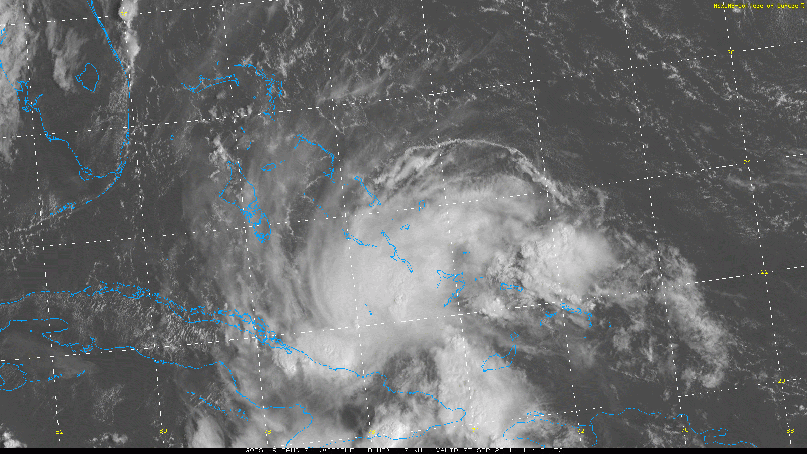
Turning to that tropical threat now, our system near the Bahamas was officially designated as Tropical Depression Nine this morning after reconnaissance aircraft was able to find a defined low level circulation near the Ragged Islands in the Bahamas. Visible satellite imagery shows that the system is becoming better organized and defined, and I would expect it will become Tropical Storm Imelda in the next 24 hours.
TD9 is moving slowly west-northwest currently, and it is expected to gradually turn more to the north over the next 24 hours and move through the central and northern Bahamas as it slowly intensifies. Tropical storm warnings are in effect for most of the central and northwestern Bahamas, and heavy rainfall and flash flooding are anticipated in the Bahamas and eastern Cuba this weekend.
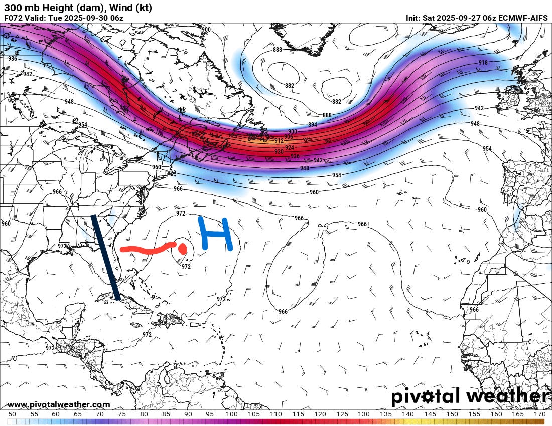
The steering flow for TD9 is incredibly complicated, and the models are struggling to grasp how it will all evolve. There are three main features driving its motion that can be seen on an upper level (300 millibar, 30-35K ft AGL) weather map valid Monday night: an upper level trough of low pressure over the southeast US (black line), an upper level high pressure center near Bermuda (blue H), and major hurricane Humberto and a weakness in the winds created by it (red dot and squiggly line).
At a high level, there appear to be 3 basic scenarios that could evolve from TD9, illustrated on the evening Google DeepMind AI forecast (above):
Scenario #1 (orange ellipse): the motion of the system is driven primarily by the upper level trough to the west and moves the system slowly but continuously inland into the Carolinas or Georgia, where it potentially stalls out midweek. As of now, I think this is the scenario that clearly has the lowest probability — although to caveat that and give you an idea of how much the models are struggling and waffling with this scenario, the late evening AI models last night actually trended more toward this idea before backing way off on the most recent run.
Scenario #2 (red ellipse): the motion of the system is driven by the upper level trough to the west for the next few days, but as it approaches the Southeast coast the steering flow between the three features I describe above completely collapses, and the system meanders near or just offshore of the coast. In this scenario, what would likely be Imelda could meander around for several days before being influenced by the next weather system moving in from the west or northwest, which could move it anywhere from inland into the Carolinas or Mid-Atlantic, or even farther north or northeast.
Scenario #3 (purple ellipse): the motion of the system to the north slows more considerably early next week, and after a brief stall, the system turns east and follows Humberto in the general direction of Bermuda and out into the north Atlantic.
At this point, scenario #3 is the evolution that is favored by most of the operational models and a majority of the AI and physics based ensemble solutions, so I think you have to say it is the most likely evolution. However, scenario #2 is still plausible, and in fact the morning run of the US global model actually trended closer to the coast with its track with a longer stall than its overnight runs.
![[Key Messages]](https://substackcdn.com/image/fetch/$s_!tcFq!,f_auto,q_auto:good,fl_progressive:steep/https%3A%2F%2Fsubstack-post-media.s3.amazonaws.com%2Fpublic%2Fimages%2F75431a78-8cab-45b3-8a2a-fc8d81c5e28f_897x736.png "[Key Messages]")
Right now, NHC’s forecast track is essentially a blend of scenarios #2 and #3. Even if the system does not make landfall, it should still cause strong winds and rough surf along a long stretch of the coast. Obviously, the closer the system gets to land, the more likely these impacts are. A tropical storm watch is now in effect along the east-central Florida coast due to the potential for the system to get strong enough and close enough to the Space Coast region to cause tropical storm force winds.
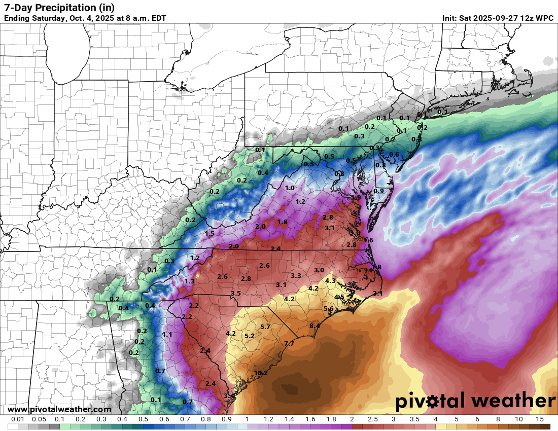
Even without a landfall, the combination of the upper level troughs of low pressure in the region and increasing tropical moisture ahead of the system will fuel heavy rainfall and potential flash flooding the next several days; in fact, a flood watch is in effect today for the Tidewater region of southeast Virginia. If scenarios #1 or #2 were to come to pass, the rainfall totals shown in the Weather Prediction Center 7-day rainfall forecast above could go up substantially, while if #3 comes to pass they could be lower but heavy rain and flash flooding would still be a risk the next several days.
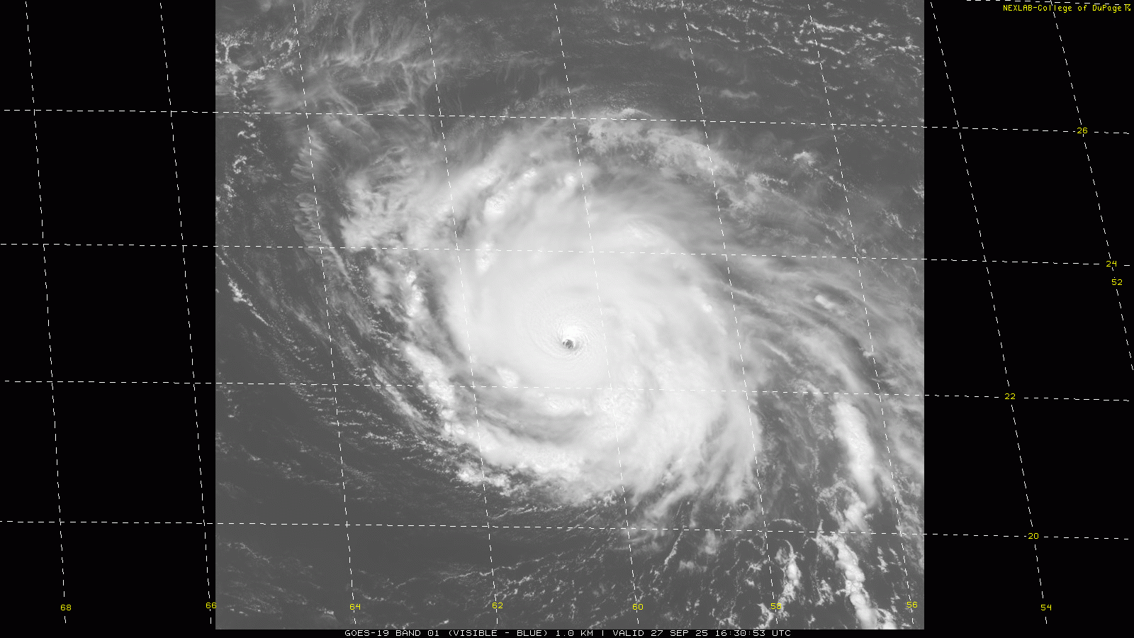
Meanwhile, Humberto is a high end category 4 hurricane moving slowly west in the central Atlantic. It looks like an absolute buzzsaw in morning visible satellite imagery, with an incredibly clear eye (you can literally see the ocean surface at the center) and vortices rotating in the eye. Humberto is still in a favorable environment for intensification and could become a category 5 hurricane at some point in the next day or two depending on internal storm dynamics.

While Humberto will move into slightly less favorable conditions early next week, it is expected to remain a powerful major hurricane the next several days. It will also grow larger, and because of this wind and rain impacts are anticipated in Bermuda as it passes the island during the early to middle parts of next week. Obviously, if the eye moves closer to the right side of the cone shown above the impacts will be greater, to the left side they will be less. Bermuda will also need to be closely watching TD9 as it could pose a significant threat late next week if it makes more of the east turn of scenario #3.
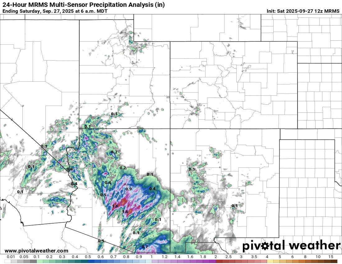
Turning to the rest of the United States, yesterday was very active day as far as thunderstorm activity across Arizona including the Phoenix metro area. MRMS shows rainfall amounts of up to 4” occurred as thunderstorms moved across the area. Phoenix Sky Harbor airport reported 1.64” of rain, which was its third highest daily rainfall total in the last decade and wettest since October 2018. Although the rainfall was welcome, flash flooding was a serious issue.

There were also a number of reports of severe weather across the Southwest on Friday, including hail up to 2” in diameter in the Phoenix area.

Additional thunderstorms and potential flash flooding are anticipated today in the Southwest US, where the Weather Prediction Center has slight (level 2 of 4) risks of flash flooding in place.

Leave a comment