Thoughts and perspectives on their investigation into the crucial EM agency. And the weekly Monday tropical deep dive.
Sep 29, 2025
Happy Monday, and Monday means a deep dive into the tropics, which continue to remain busy and look as if they will likely stay so for the foreseeable future. Before I get into that, though, I want to highlight this important and relevant article published this morning in the Wall Street Journal about the Federal Emergency Management Agency (FEMA) (thanks to Paul Walsh for highlighting it on his Substack).
The article is a devastating expose of the incredible dysfunction that has overwhelmed FEMA in the last six months, making its crucial disaster response and recovery work increasingly ineffective. The article focuses on the agency’s response to the devastating violent tornado that struck the St. Louis metropolitan area on May 16th of this year:
St. Louis is a test case for the Trump administration’s new policy of shifting more responsibility for natural disasters to states and cities. City officials and local residents who are still clearing rubble from destroyed buildings four months after the tornado struck said the experiment isn’t going well.
Many of FEMA’s core functions related to preparing for natural disasters and leading recovery efforts after they strike have ground to a halt as the Trump administration redefines the agency, according to more than a dozen FEMA employees and local officials, as well as a review of internal government documents.
Crucial contracts and grants haven’t been approved, caught up in layers of new bureaucracy. A wave of senior staff departed the agency when Elon Musk’s Department of Government Efficiency offered buyouts, taking decades of experience with them. Around 400 FEMA employees have been detailed to work at U.S. Immigration and Customs Enforcement, as that agency rapidly expands. And the administration has started dismantling the agency’s disaster-response infrastructure, which was strengthened in the aftermath of Hurricane Katrina in 2005.
The scaled-back federal response has left places like St. Louis in a bind. The city doesn’t have the finances, institutional knowledge or equipment to rapidly respond to catastrophic disasters like the tornado that struck in May, which the city estimates caused $1.6 billion in damage.
I cannot overemphasize how incredibly concerned (and to be honest, angry) reading these paragraphs make me. If anything positive came out of Katrina, the tremendous improvements to emergency management at the federal and state levels — particularly in Louisiana — in my opinion would qualify. The fact that the administration is specifically targeting those improvements for dismantling is absurd.
Furthermore, the continued messaging from the Trump Administration that they are “shifting more responsibility for natural disasters to states and cities” is patently ludicrous. To reemphasize yet again, emergency management in this country is already established legally and structurally so that the primary responsibility rests at the local level. States become involved when local communities are overwhelmed by a disaster, and feds become involved when states are overwhelmed. State emergency management agencies and FEMA provide support and coordination to the levels below them — but the primary responsibility for the four phases of emergency management (mitigation, preparedness, response and recovery) already resides at the local level.
This is the money quote from the above section of the WSJ story: The city doesn’t have the finances, institutional knowledge or equipment to rapidly respond to catastrophic disasters like the tornado that struck in May, which the city estimates caused $1.6 billion in damage. This is the exact reason why a robust FEMA is SO critical to our nation. Any one individual municipality, county or even state can go years to decades without a major disaster that they have to respond to. The idea that these levels of government are going to maintain the large, complex infrastructure needed to effectively and adequately respond to rare catastrophic events is not only nonsensical, it would be an incredibly poor use of taxpayer money. Having a robust FEMA enables the ongoing maintenance of the needed disaster response infrastructure at a federal level which can then be deployed when and where it is needed.
I strongly encourage you to read the entire article. We have been incredibly lucky this hurricane season that the three major Atlantic hurricanes have avoided landfall and that we have avoided a major regional scale disaster in the last few months. However, this Wall Street Journal investigation makes it clear that FEMA is struggling to respond to even “smaller” disasters where their help is needed. In my opinion, we should be very concerned about our national capacity to respond to the next catastrophic event we have to deal with.
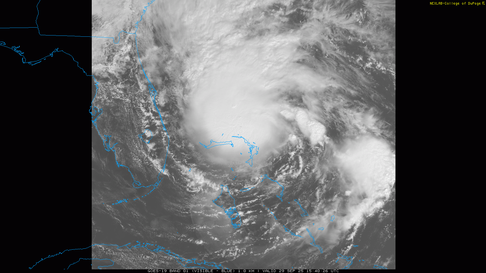
Let’s start off our Monday tropical dive with a storm that the US is lucky to have avoided for the most part, Imelda. Morning satellite imagery shows that Imelda is definitively on the upswing this morning, with a well defined central core of thunderstorm activity near the center and bands of thunderstorm to the north and east. Reconnaissance aircraft in the center have found that the pressure has been falling, now down to 988 millibars, and that maximum sustained winds have increased to 60 mph.
Imelda is still moving slowly north, but within the next 24 hours it should slow down again and then start moving more rapidly to the east-northeast as it becomes enmeshed in the flow surrounding major hurricane Humberto. Conditions look favorable for strengthening the next couple of days, and even as shear starts to increase in the middle of the week, a favorable interaction with an upper level trough of low pressure could keep Imelda steady or even somewhat strengthening. For now, NHC has Imelda forecast to become a category 2 hurricane, and it does not seem out of the realm of possibility that it could at least briefly become a major hurricane (if it did, it would make the Atlantic 4 for 4 on hurricanes being major so far this season).
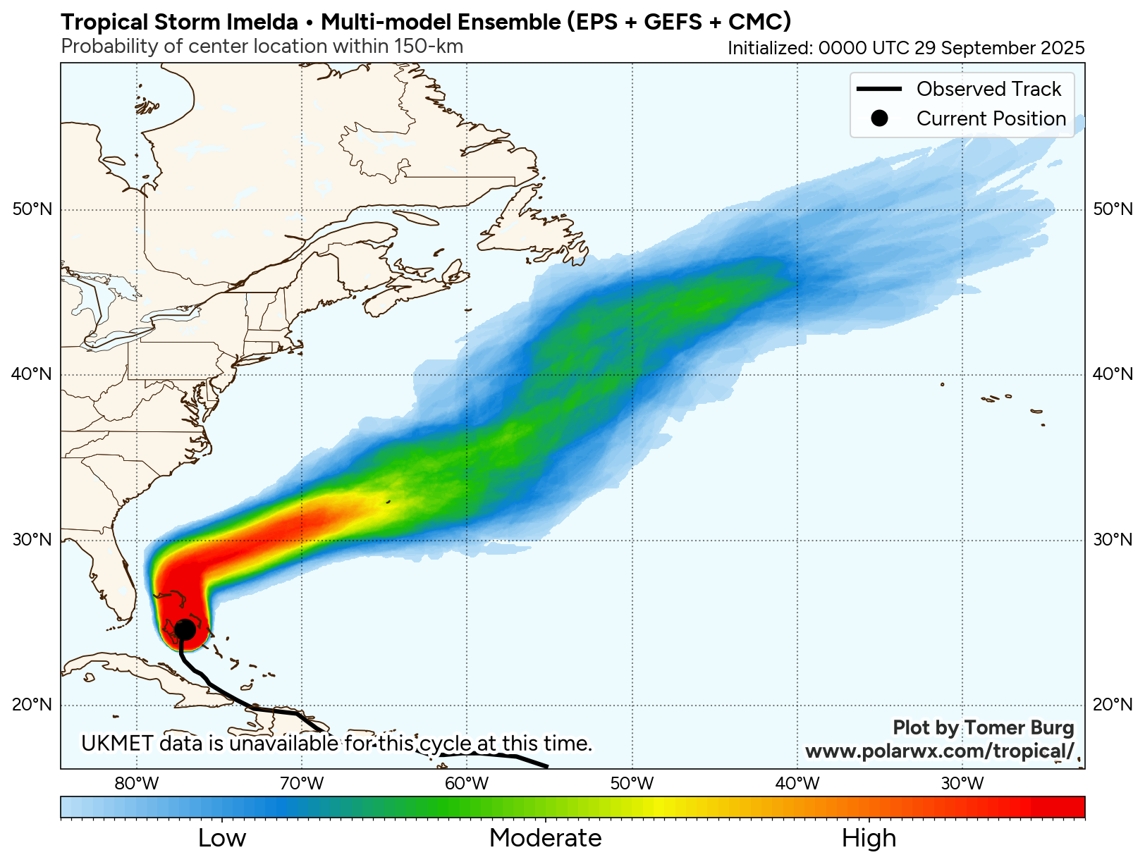
The model consensus suggests that Imelda will move near Bermuda as a hurricane during the midweek period, and a hurricane watch will likely be issued for the island later today. While there is obviously some uncertainty about the exact track and intensity as it passes the island, the potential for significant impacts exists and interests in Bermuda should be preparing accordingly.
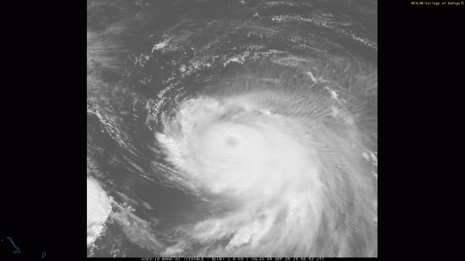
Before Bermuda deals with Imelda, it will first have to get through a glancing blow from major Hurricane Humberto. Visible satellite this morning shows that Humberto is not quite as impressive as yesterday, with the eye not as clear and a bit less impressive thunderstorm activity. However, a USAF reconnaissance aircraft has been in Humberto this morning, and found that it is still an intense category 4 hurricane with maximum sustained winds of 145 mph.
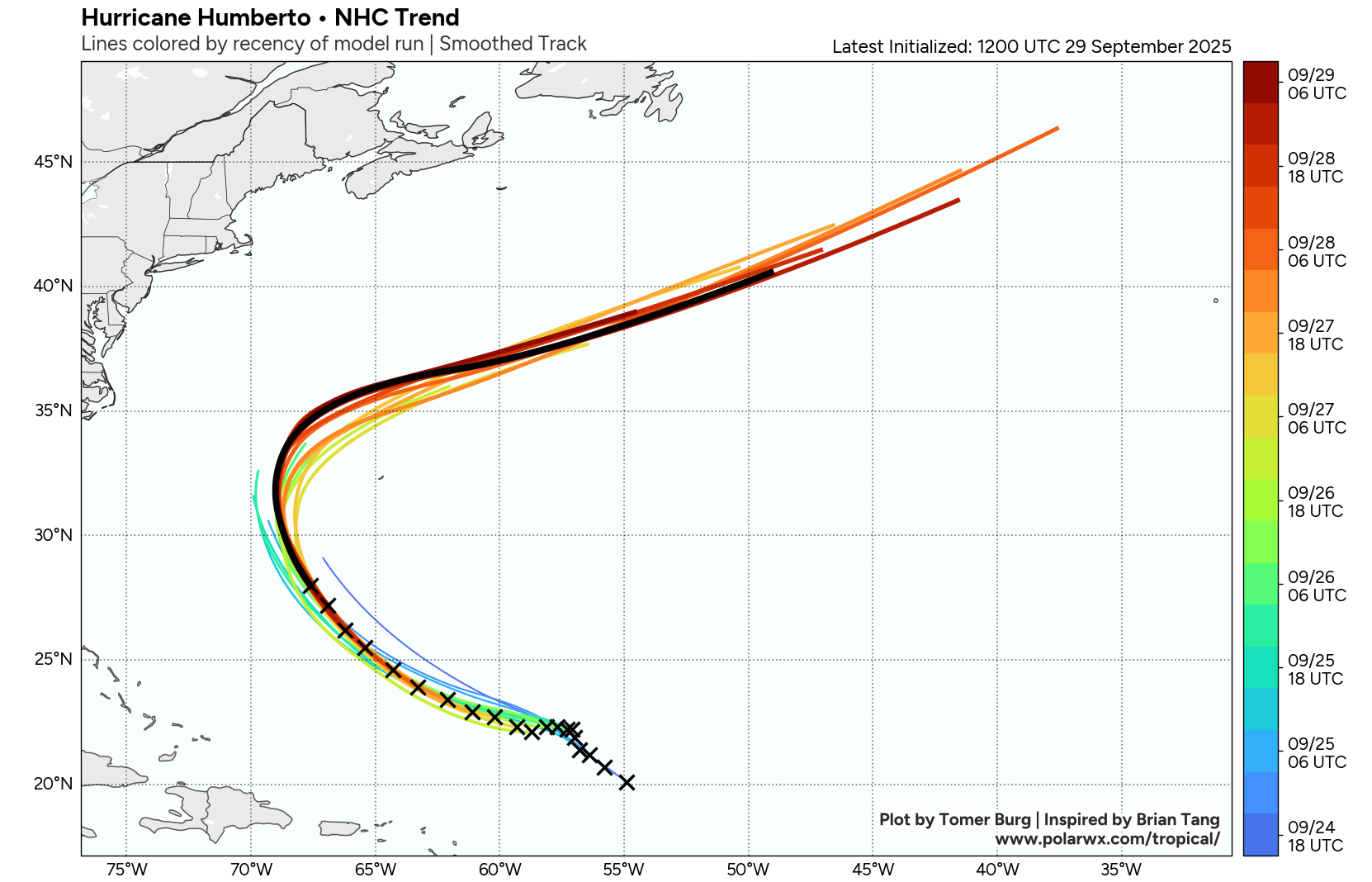
In contrast to what it has seen with Imelda, the forecast trend with Humberto has been favorable for Bermuda, as it has continued to shift farther west and northwest —the black line in the forecast graphic above is most recent NHC forecast with earlier forecasts colored as shown in the legend at right — meaning the impacts will be less. Still, high surf, gusty winds and some squalls will be experienced, and a tropical storm watch remains in effect for Bermuda.
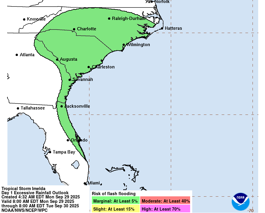
As far as any impacts to the US from either of these systems, the continued shift in the forecast track for Imelda has further decreased the heavy rainfall risk, with just marginal risks for flash flooding now across the Carolinas and coastal Georgia and Florida. Swell and high surf from both tropical systems combined with strong winds between the tropical systems and a strong high pressure system will create dangerous marine and beach conditions along much of the East Coast the next several days.
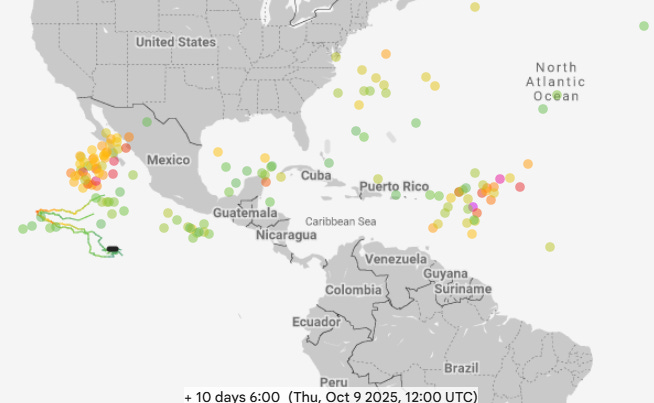
After Humberto and Imelda finally become post-tropical late this week, the models suggest that the Atlantic will likely stay active. The Google DeepMind (GDM, 10 day forecast shown above) AI system shows the potential for development in a few different areas: east of the Caribbean, in the vicinity of the Yucatan Peninsula, and in the Southwest Atlantic. The GDM has been particularly bullish on the tropical wave east of the Islands, consistently showing it developing into a significant hurricane in about 7-10 days. Meanwhile, the physics based European ensemble seems more focused on the potential for development in the Gulf or northwest Caribbean in the week 2 period, an area that is more favored climatologically as we get into October. Regardless, it seems likely that this post-peak active period will continue.
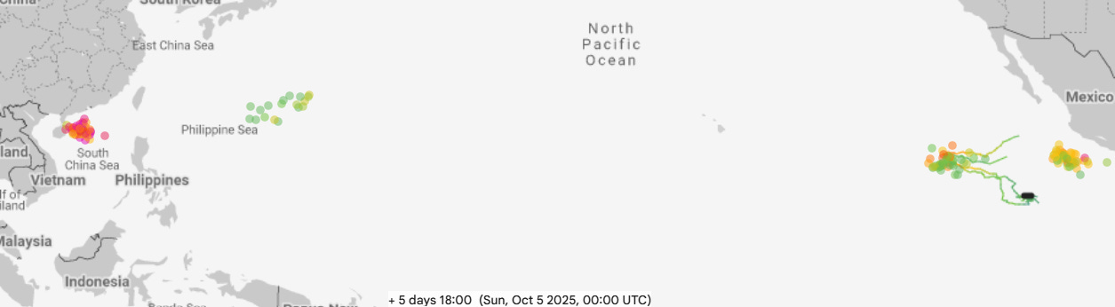
Taking a quick look at the Pacific, Typhoon Bualoi which we discussed last week made landfall in central Vietnam in the last 24 hours, causing intense winds, flooding and storm surge with at least 13 people killed. This is in addition to severe damage caused earlier by Bualoi in the Philippines which left 20 dead. Bualoi will continue to weaken as it moves inland over Southeast Asia, but the GDM system (5 day forecast shown above) suggests another intense typhoon will develop between southern China and the northern Philippines later this week and threaten the region.
In the eastern Pacific, NHC is monitoring Invest 98E which is forecast to become a tropical storm or hurricane as it moves west well offshore Mexico (western system shown on GDM forecast above). An additional system closer to the coast is forecast to develop as well, and longer range ensembles suggest this could become a powerful hurricane that could eventually pose some risk to Baja California and maybe provide some moisture to the Southwest. However, this would be a number of days away, so for now it is just something to be aware of.
A programming note: I will be on a trip to the Northeast starting tomorrow, so my posts will be a bit more irregular for the next week or so. I am planning some live content from my travels, including hopefully from a weather “mecca” location I am excited to finally get to visit, Mount Washington, NH. As a reminder, live content (video and chat) are available to all Balanced Weather paid subscribers.
Finally, acknowledgments and thanks to PolarWx.com, College of DuPage, Weathernerds, and Tropical Tidbits for their incredible websites that allow the weather community to obtain and visualize meteorological data in so many incredible ways.

Leave a comment