Dr. Neil Jacobs through preliminary vote to be confirmed as NOAA Administrator. Also, a look at the busy tropics.
Oct 05, 2025
Important correction: My original version of this post stated that Dr. Neil Jacobs had been confirmed as NOAA Administrator was based on this article from the Raleigh News and Observer. I have since learned that this article is in error. The vote on Friday was the cloture vote on the list of nominees — the final vote is scheduled for tomorrow. I have corrected the post below and apologize for the confusion — I should know better than to post something like that while traveling and not being as plugged in as usual!
Good morning! I am still traveling, but am in a stable location for about 24 hours and wanted to provide some updates on a few items. First, even with the federal government shutdown, the Senate was in session on Friday and approved the cloture motion to end debate for one of their en bloc list of nominees for Trump Administration executive branch positions that require Senate confirmation. Friday’s list included Dr. Neil Jacobs nomination to be Under Secretary of Commerce and NOAA Administrator (director). The cloture vote sets up the final votes, which are scheduled for tomorrow, and assuming they are approved as expected, Dr. Jacobs will be confirmed.
Dr. Jacobs was the Assistant Under Secretary of Commerce during the first Trump Administration, and is a well known scientist in the meteorological community who played a key role in developing the Earth Prediction Innovation Center (EPIC) program to help unify US research and development of numerical weather prediction computer models. As the article discussing the confirmation above notes, he was also embroiled in the so-called “Sharpiegate” controversy when he was acting NOAA Administrator toward the end of the first Trump presidency.
When his confirmation is final, I assume Dr. Jacobs will be sworn in as NOAA Administrator as soon as possible. He obviously takes over leadership of NOAA at a very precarious time, with the imminent concern being the ongoing government shutdown and potential for the administration to implement permanent reductions-in-force to parts of the government. While the National Weather Service has continued to perform forecast and warning services during the shutdown, most federal NOAA Research scientists are furloughed, significantly hampering R&D projects. Obviously, the next week will likely be busy with federal government science news, and I will update as I can.

Weatherwise, the storm system that will finally bring a halt to the unseasonable warmth that has been dominating much of the country will be moving across the north central region of the US today, bringing rain and mountain snows. Scattered thunderstorms will also continue over the Southeast.
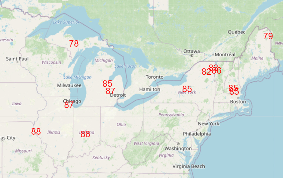
Ahead of the north central US system, near record warmth will continue into the first part of the week (NWS forecast temperatures for Sunday near or above record highs shown above).
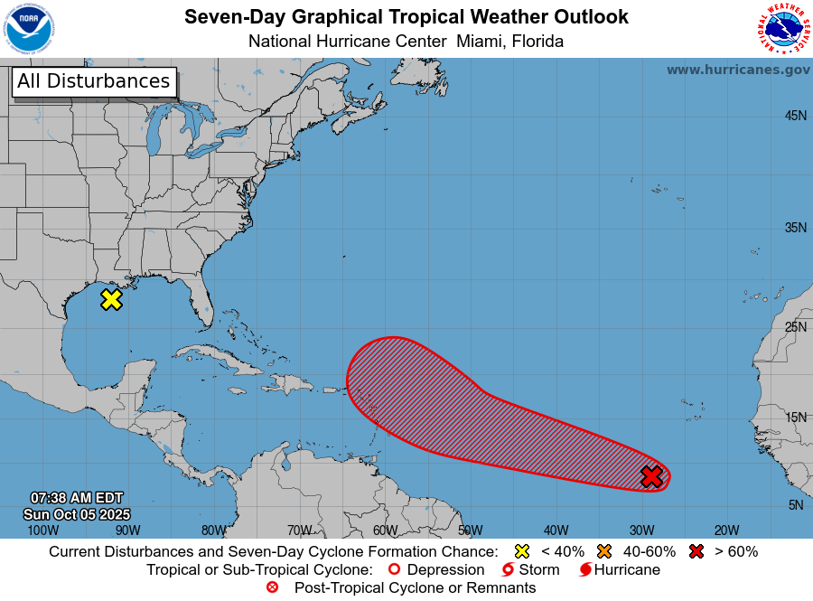
The tropics remain active, with newly designated Invest 95L in the eastern Atlantic. This system is showing some early signs of organization, and the National Hurricane Center now has a high risk (70%) probability of it developing into a tropical cyclone the next several days. While the eastern Caribbean needs to keep an eye on this system, current model forecasts (and the time of year) suggest this system should not pose a threat to the US. A weak area of low pressure in the northern Gulf is not expected to develop (near 0 chance per NHC), while the system in the southwest Atlantic we were discussing has also become a minimal risk for development.
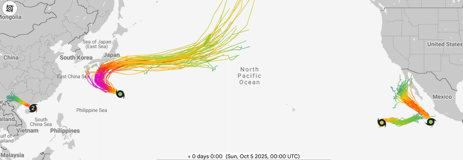
The Pacific is even more active. Typhoon Matmo made landfall in southern China in the last 24 hours as the equivalent of a category 2 on the Saffir-Simpson Hurricane Wind Scale. It will continue to produce flooding as it moves east. Tropical Storm Halong is expected to become a powerful typhoon the next few days as it moves northwest in the general direction of Japan. Current forecasts anticipate it recurving before it reaches the island nation, but obviously we will keep an eye on that.
In the eastern Pacific, category 1 Hurricane Octave (westernmost system in eastern Pacific on Google DeepMind forecast above) is on a weird east movement, but is forecast to weaken and eventually dissipate in the next few days. Meanwhile, Tropical Storm Priscilla is expected to become a large hurricane as it moves northwest this week. While it currently appears that it will pass well west of Baja California, it could provide enhanced moisture to northwest Mexico and the Southwest US in several days.
Note: As a reminder, my posts will continue to be more erratic the next few days as I will be traveling.

Leave a comment