First tornado rated EF-5 in United States in 12 years. Also talking record warmth and tropical Atlantic risks.
Oct 06, 2025
Good evening from rural northern Vermont — I don’t have great internet connectivity here, but I wanted to share some news from earlier today that the National Weather Service has upgraded the tornado that occurred near Enderlin, ND on June 20th from an initial EF-3 rating to an EF-5 tornado with maximum winds greater than 210 mph. The change in rating was due to additional analysis the NWS did in collaboration with experts in engineering and tornado damage, including the Northern Tornadoes Project.
Back shortly after the tornado occurred, I did a post that was a deep-dive on this event and explained why I suspected that this was a violent tornado. The Enderlin tornado is now the first EF-5 tornado since the Moore, OK tornado on May 20, 2013, ending a 12 year “drought” which was the longest on record. I talked with National Severe Storms Laboratory scientist Dr. Tony Lyza back in May about that drought and recent trends in tornado damage rating that might have contributed to such an extended period without an EF-5 tornado. I strongly encourage you to watch that interesting conversation to get more background on the process of tornado damage rating and why we may be seeing some artificial trends in the tornado climatology due to changes in that process.
On a different note — I have been experiencing some all-time fall record warmth the last few days as we have been traversing the US-Canadian border region. We were in Montreal yesterday, where the temperature at Pierre Trudeau International Airport hit 29.9C (86F), which set a new record for the warmest October temperature on record there. This was part of dozens of all-time record monthly warm maximum and minimum temperatures across Canada and the northern United States the last few days. Today we were in the Burlington, VT area, where a record high of 84F was set today after yesterday saw an all-time monthly record of 86F.

That extended period of warmth will finally be coming to an end over the next day or so as a storm system and associated cold front presses east.
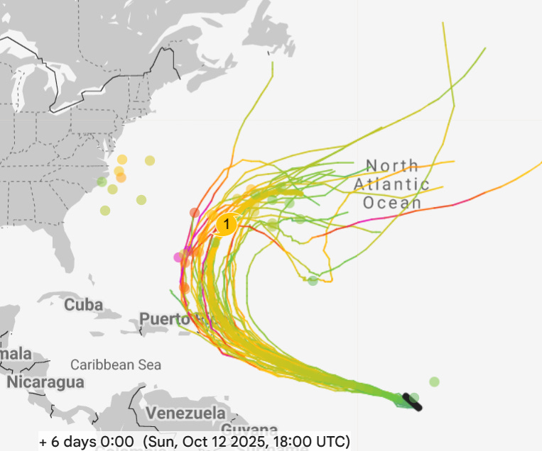
The Atlantic tropics continue to be active as well, with Invest 95L in the eastern Atlantic now having an 80% chance of developing into a tropical cyclone in the next couple of days. While most of the model trends suggest the system saying just east and northeast of the islands of the northeast Caribbean (Google DeepMind 6 day forecast for this weekend shown above), it is certainly close enough to require monitoring. We will also be keeping an eye off the Southeast and Mid-Atlantic coast for potential development later this week — while this system would be more of a hybrid system than a pure tropical system, it could potentially produce some impacts along the East Coast. More on this as the week goes on.

Leave a comment