Major coastal low to impact the East Coast for several days while heavy rains likely again in the Southwest from moisture from Tropical Storm Priscilla
Oct 09, 2025
I am back from my Northeast travels, and I will have content to share in coming days about that trip, particularly my trip to Mount Washington. I also have perspective I want to share about what is happening with the government shutdown and potential short and longer term impacts to NOAA and federal science. Before I get to all of that, though, there are a lot of weather impacts to talk about in the coming days, so I want to focus on all of that today.
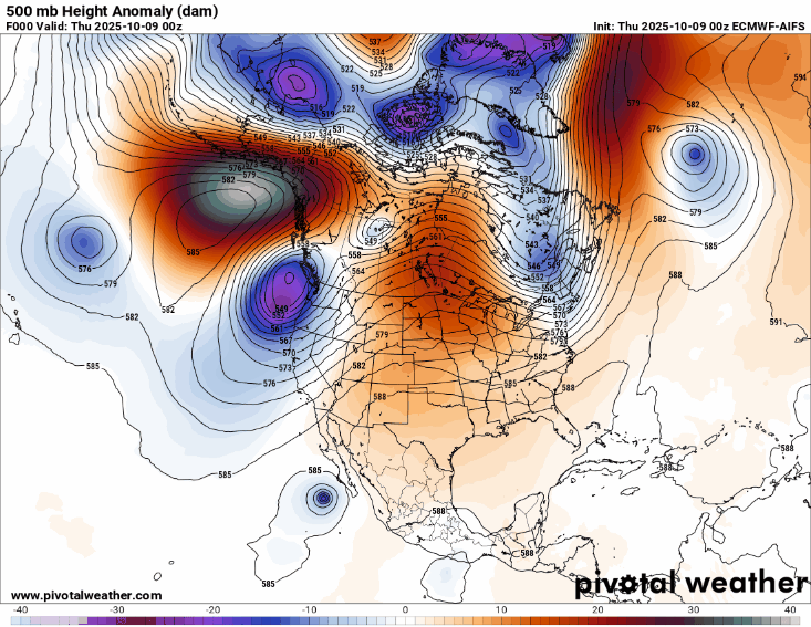
I am not sure I have ever posted a loop of charts from 500 millibars (mb, 18K ft AGL) before, but I wanted to start with this today for several reasons. Meteorologists look at the 500 mb level of the atmosphere closely because it is where we can typically best see the middle and upper level weather systems and wind flow that drive the sensible weather at ground level. What I have posted here is a forecast loop for the next three days from the most recent European AI model of 500 mb heights — the contours, equivalent to isobars or pressure lines on a surface weather map — and the image is the height anomalies, i.e., how much above or below normal the height values are.
This forecast loop reveals an incredibly complex mid and upper level flow pattern across North America and the adjoining Pacific and Atlantic regions. An unusually intense ridge of high pressure over the northern Pacific — likely associated with the massive marine heat wave we have talked about in that region and which Andrew Freedman at CNN talked about the impacts of in an article today — looks to be anchoring a highly amplified pattern of low pressure troughs and high pressure ridges across much of the Northern Hemisphere. A strong low pressure area can be seen rotating along the West Coast, while downstream of that another unusually strong ridge of high pressure is building across the central part of North America.
We are still early enough in the fall that this amplified weather pattern in the northern latitudes is having significant interactions with organized tropical systems. An upper level of area of low pressure will be evolving along the US East Coast, which will drive the development of a low pressure storm system at the surface. This low will be over the warm waters off the Southeast US Coast, meaning it will be spawning thunderstorm activity and could gradually take on some tropical characteristics with time.
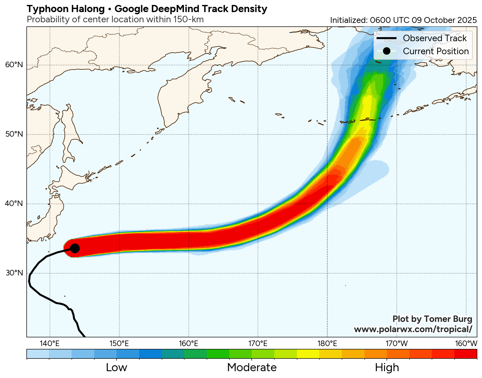
Meanwhile, Typhoon Halong, which is currently a typhoon with 100 mph sustained winds just east of Japan, will be recurving across the northern Pacific Ocean toward the Aleutian Islands the next several days as it becomes an intense post-tropical system. Transitioning poleward moving typhoons are a critical forecast challenge at this time of year not only for the specific impacts they can cause in Alaska, but also because they play a major role in the downstream weather pattern across North America. The models typically struggle with these types of forecasts and it is not unusual to see significant uncertainty in the model ensemble forecasts across North America when an upstream typhoon is transitioning. With an already complex upper level weather pattern in place as I described above, the uncertainty will be even greater and more magnified for our forecasts over the next several days.
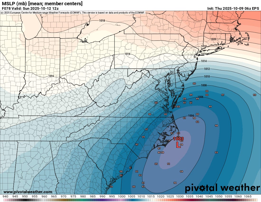
This forecast uncertainty is clearly seen in the developing system off the East Coast. While the general idea of deep low pressure developing in the region of the Mid-Atlantic this weekend is in most of the model forecasts, the details in timing, track and evolution are quite uncertain. The chart above is the surface pressure forecast derived by taking a mean (average) of the 50 European ensemble forecasts for Sunday morning. It shows a relatively strong low pressure system near Cape Hatteras. Each of the tiny numbers on the chart, though, is the position and intensity of a surface low in one of the ensemble members, and you can see that they are all over the place. If one looks at each ensemble forecast individually, the extremes in potential outcomes becomes apparent, varying from a more intense and tropical system developing near the Gulf Stream to a much weaker system farther north or south to a double barreled system with intense lows both off the Carolinas and off of Long Island.
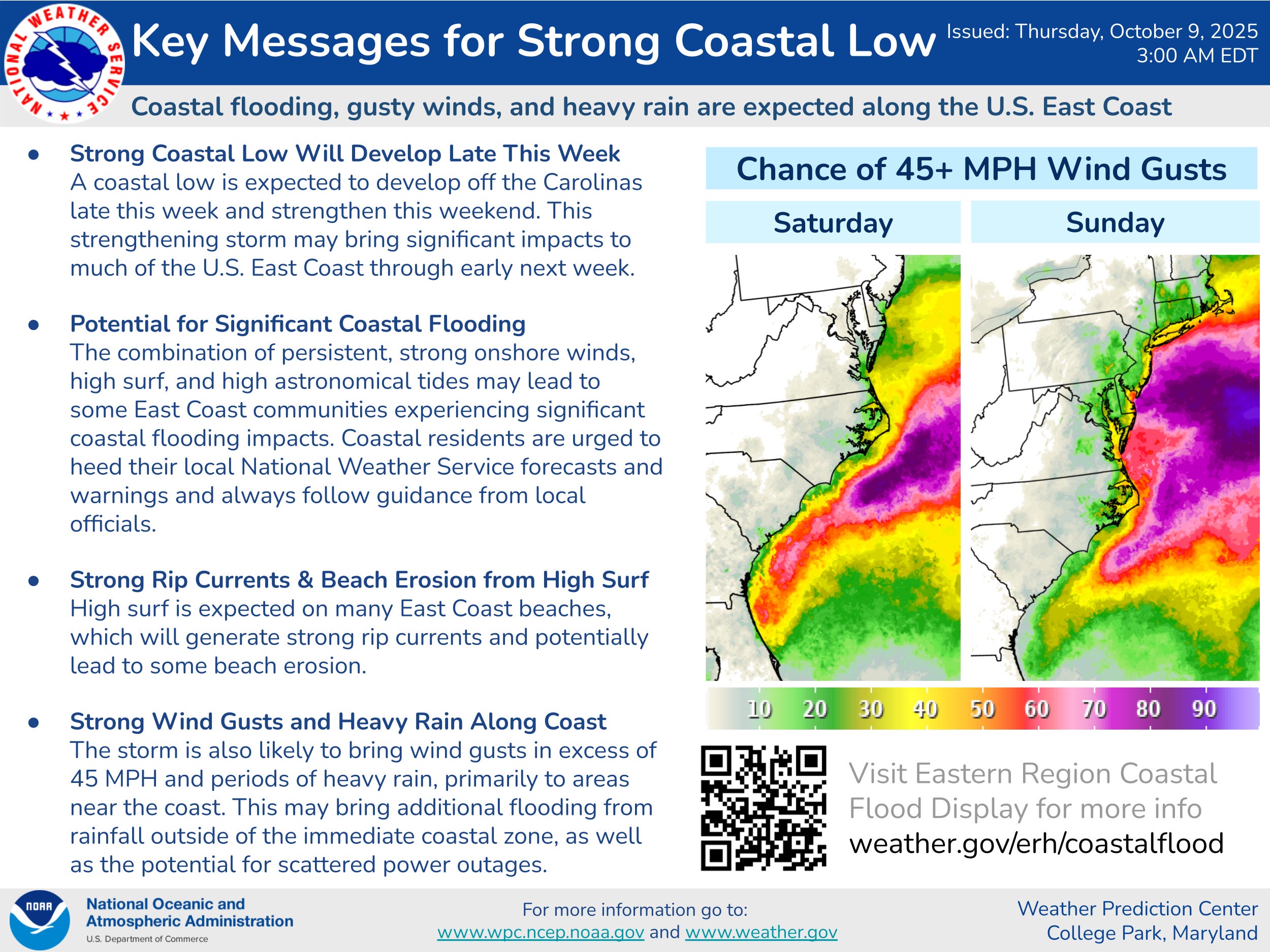
While there is a lot of uncertainty in the the details, the overall idea of a multi-day high impact event with significant coastal flooding, high winds, and heavy rain is a pretty likely scenario. These key messages from the Weather Prediction Center outline the current expectations well, obviously the specifics as far as timing and impacts will evolve as we get a better handle on the forecast.
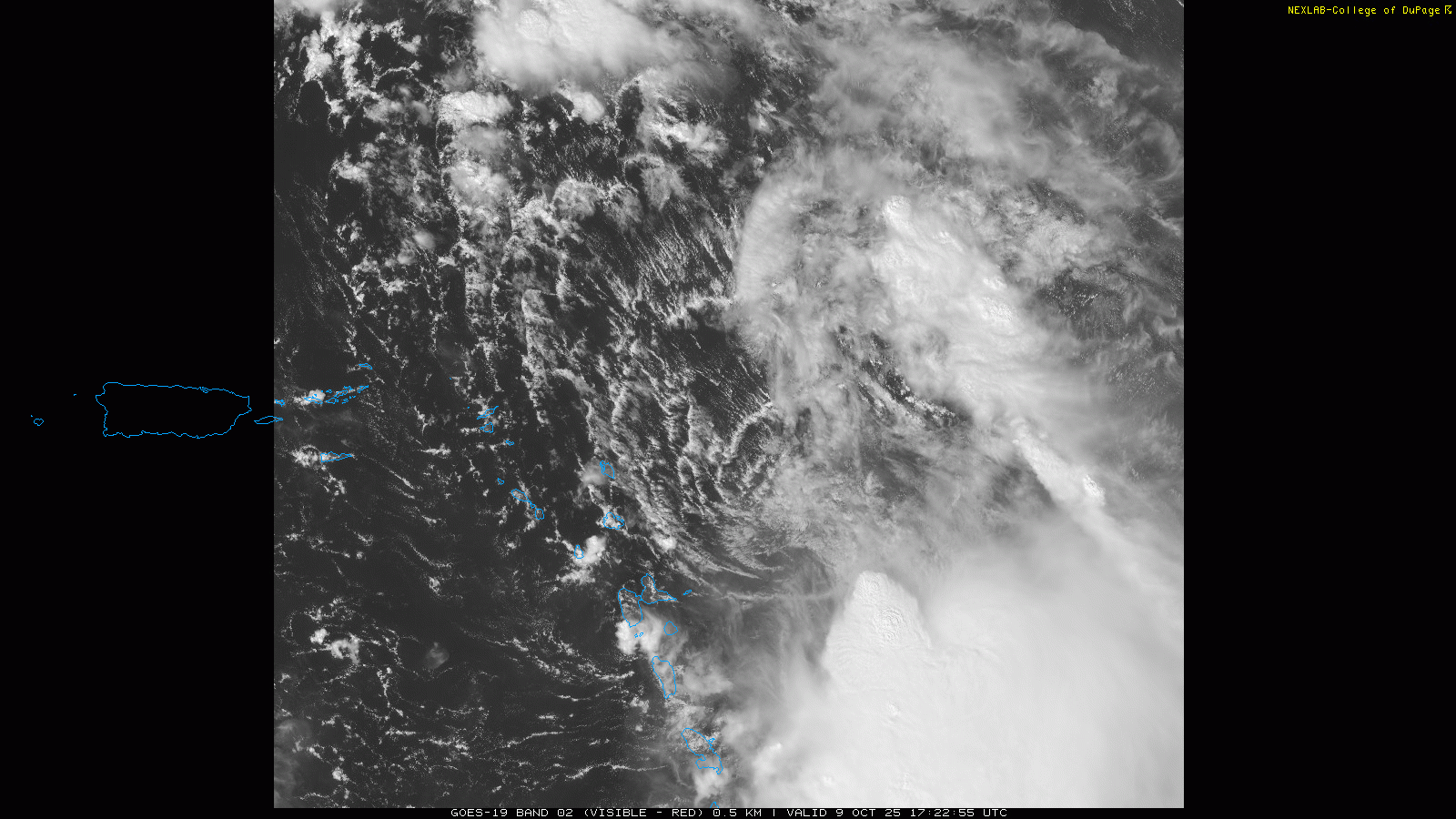
The longer term forecast for Tropical Storm Jerry will also be influenced by how the system along the East Coast evolves. Right now, the visible satellite imagery above shows that Jerry is a rather disorganized tropical storm, with all of the thunderstorm activity well southeast of an exposed low level circulation just east of Guadeloupe. This is the result of strong west-northwest wind shear in the atmosphere. That shear is forecast to weaken over the next day or so and Jerry is forecast to become a hurricane. However, as with the low pressure system off the east coast, the model scenarios from the hurricane models and the global ensembles for Jerry are all over the place, varying from the system remaining relatively disorganized to it becoming a major hurricane.
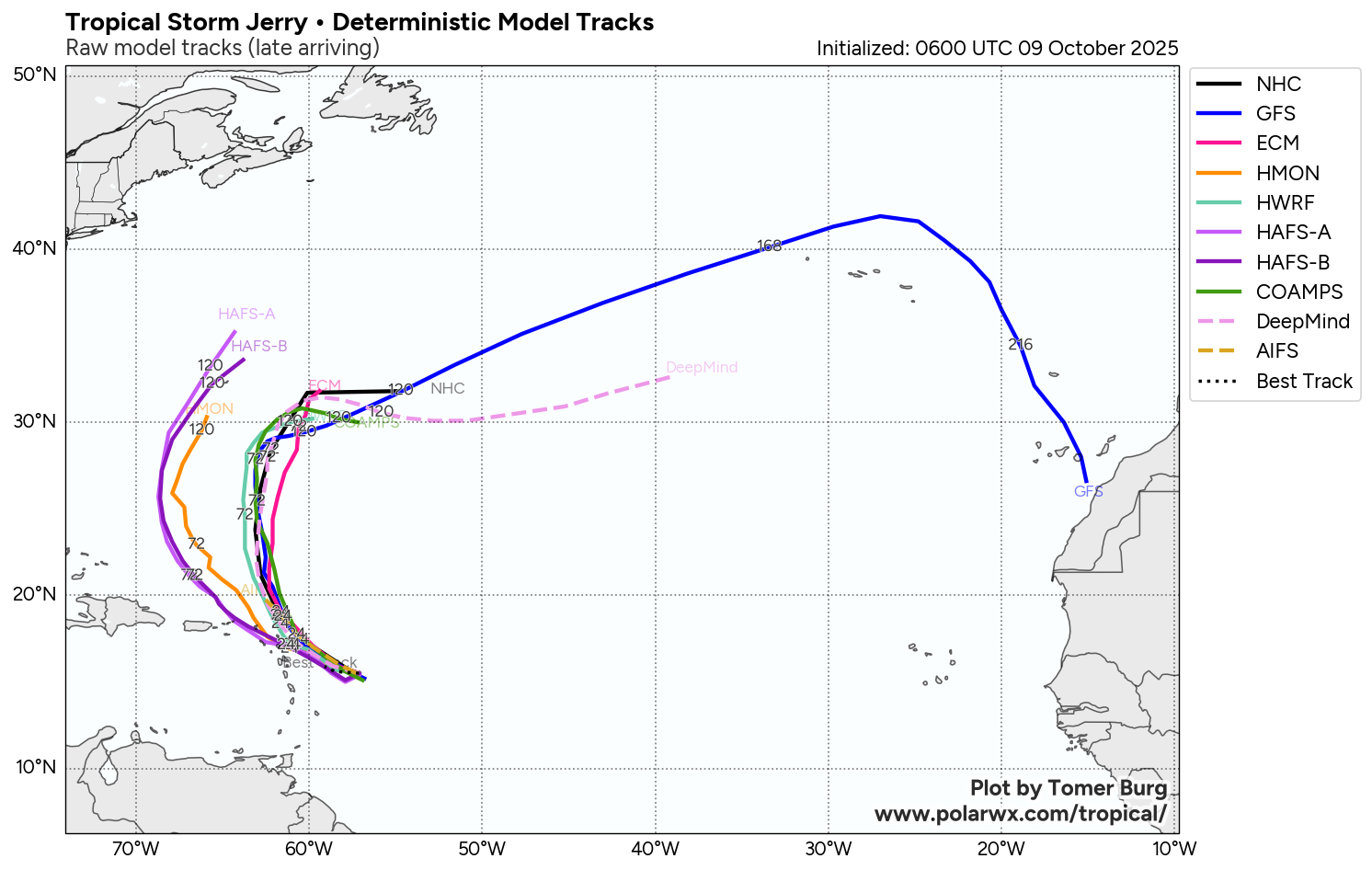
While most of the models show Jerry recurving southeast of Bermuda, a few of the ensemble solutions as well as some of the hurricane models have shown a farther west track closer to (or even west of) Bermuda. Given the uncertainty we talked about with the overall pattern across the Northern Hemisphere and the potential for sudden forecast changes, we will obviously want to keep an eye on Jerry.
In the short term, the center of Jerry will be passing very close to the far northeast Caribbean islands in the next several hours, but with all of the thunderstorms and squally weather east and southeast of the system, the weather will likely not deteriorate significantly in the northeast Caribbean until tonight and into Friday when the center gets north of those islands. Tropical storm warnings are now in effect for Barbuda and Anguilla, St. Barthelemy and St. Martin, and Sint Maarten, with tropical storm watches for the surrounding islands. Tropical storm force winds — especially in gusts — are possible along with up to 6” of rain which could produce flash flooding.
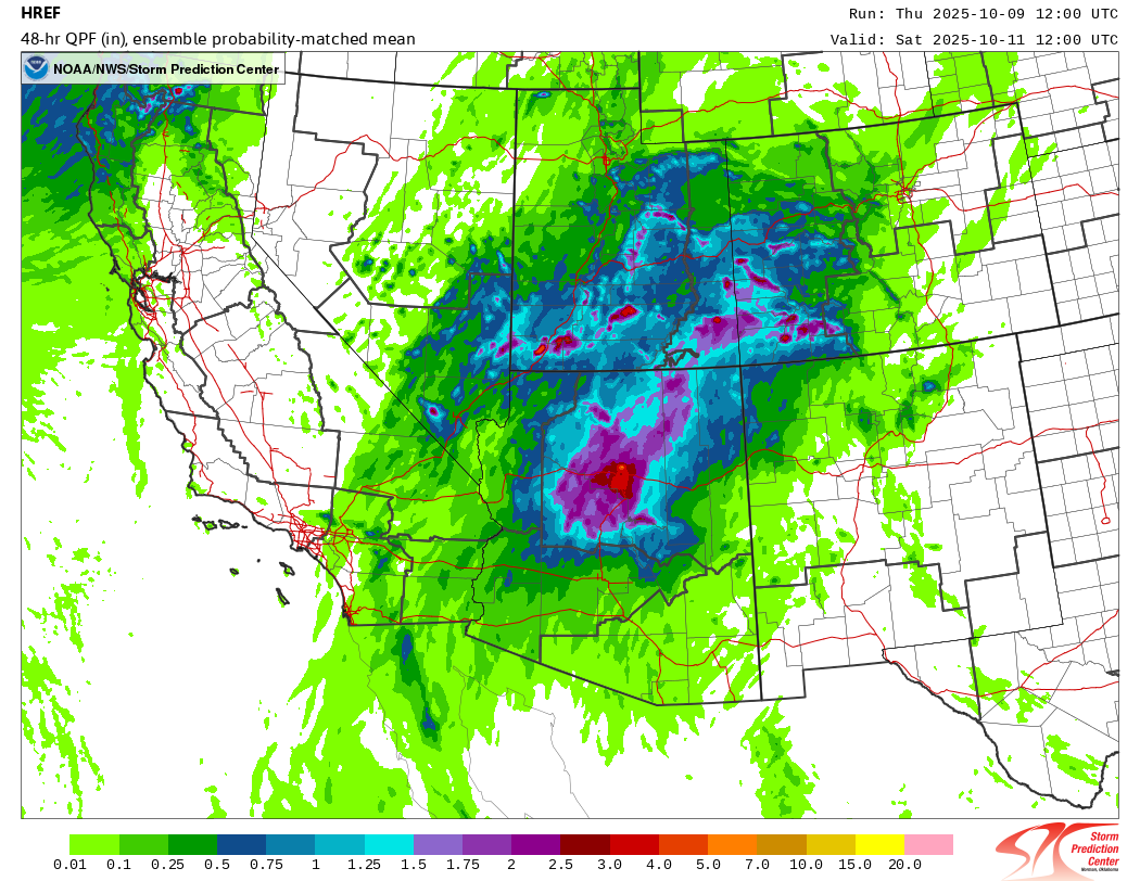
In the eastern Pacific, Tropical Storm Priscilla is weakening west of Baja California, but tropical moisture from the tropical storm will be pulled northeast into the Southwest by the upper level low pressure center off the west coast I talked about above (if you look at the loop above, you can see how the low pressure center of Priscilla gets pulled northeast and absorbed by the much larger low off California). This is expected to bring the potential for exceptionally heavy rainfall rates, particularly to the mountains from northern and central Arizona north into Utah and western Colorado. The morning High Resolution Ensemble Forecast above shows the potential for localized rainfall totals of up to 5” in these areas.
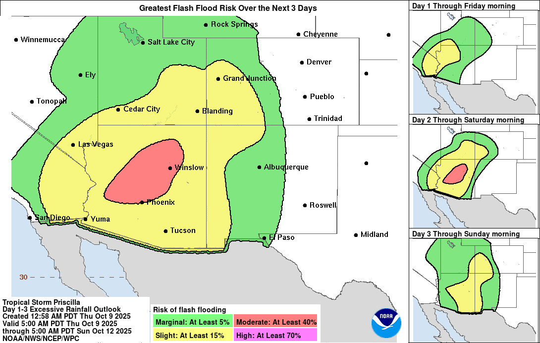
While this much of this area is in moderate to severe drought, the high rainfall rates in this typically dry region will bring risks of significant flash flooding. The Weather Prediction Center has a moderate (level 3 of 4) risk of flash flooding for Friday and Friday night from the northern side of Phoenix across northeast Arizona. Slight (level 2 of 4) risks of flash flooding will encompass surrounding regions much of the next 48 hours.

Leave a comment