In weather, significant coastal impacts peak on the East Coast next 36 hours, while flash flooding continues to impact parts of the Southwest
Oct 12, 2025
Following up on my post yesterday about the firing of more than 1,000 scientists and staff at the Centers for Disease Control and Prevention (CDC) and potential implications for the broader federal science community, last night multiple media sources reported that the Department of Health and Human Services says that a number of these terminations were in error and are being rescinded.
It is unclear exactly what positions will be affected by these reversals, but ABC News reports this morning that while most of the CDC firings will still go into effect, staff responsible for the renowned Morbidity and Mortality Weekly Report (MMWR) and staff working on measles outbreaks in the US and Ebola outbreaks overseas will see their terminations reversed. An HHS official blamed the “accidental” firings on “coding errors,” and said that the “employees mistakenly laid off will receive a formal notice rescinding their elimination ‘eventually,’ likely within a matter of days.”
First off, I am very skeptical of this explanation that these firings were “accidental” and due to coding errors. Terminating a federal employee is typically not as simple as running a computer program that generates pink slips. There is a whole host of bureaucratic processes that should have to be completed and approved by various officials, and the idea that all of this could happen “accidentally” without anyone noticing the error seems very dubious to me. A more likely explanation would seem to be that there was tremendous political blowback from senior Republican Congressional officials behind the scenes that resulted in a reversal. If the explanation provided to ABC about accidental firings due to coding errors is in fact true, I almost feel like that is even more worrisome because it would imply that the administration is essentially just firing people based on job codes and with little regard for specifics or nuance.
It may seem odd that I am spending so much time in a weather and climate focused Substack talking about what is happening at the CDC. One reason is to emphasize that the federal weather, water and climate science apparatus is much bigger than NOAA. For example, the CDC has significant responsibility for tracking heat related morbidity in the US and developing science-based safety recommendations to enable the public to protect themselves from heat stress. While NOAA — and particularly the National Weather Service (NWS) — is the central federal entity for weather, water and climate science, multiple agencies across many cabinet departments play crucial roles, from USGS (Department of Interior) to NASA to the Departments of Defense and Energy (and more). Erosion in the capabilities of these agencies potentially erodes the overall federal meteorological enterprise.
Furthermore, as I talked about yesterday in my opinion what is happening at the CDC is clearly symptomatic of the diminishing appeal of the federal government as a career option for top scientists. The administration has already fired and then had to rehire hundreds of employees in recent weeks, and given that hundreds of CDC employees were already fired and rehired earlier this year it seems plausible that some CDC employees are now going through this situation a second time. This just adds to a growing list of ways in which federal employment is becoming much less attractive, and as the NWS looks to rehire the hundreds of people lost earlier this year, I fear that it will be much more challenging to attract top candidates than in the past.
Learn about other BalancedWx Services
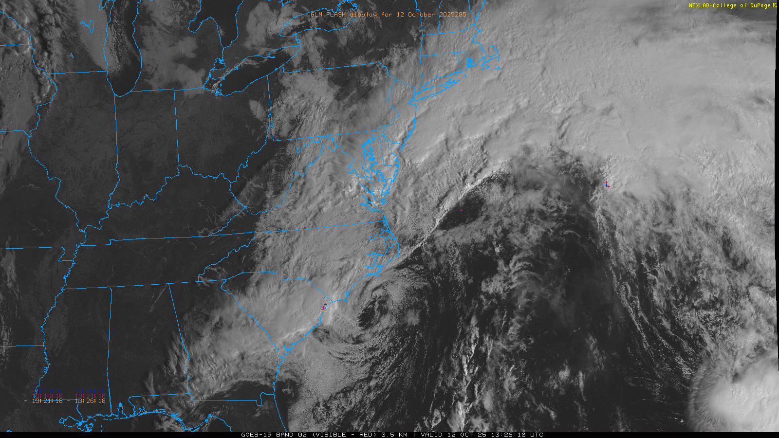
Turning to weather, first light visible satellite imagery shows a well developed, strong area of low pressure centered just off the southeast coast of North Carolina. As expected, this low is clearly non-tropical with very little thunderstorm activity associated with it. The models have continued to hint at a new low developing farther north off the Mid-Atlantic, and this is the area where there has been a bit more of a sign that a somewhat more subtropical system could evolve. As of now, though, there is not any sign of that occurring.
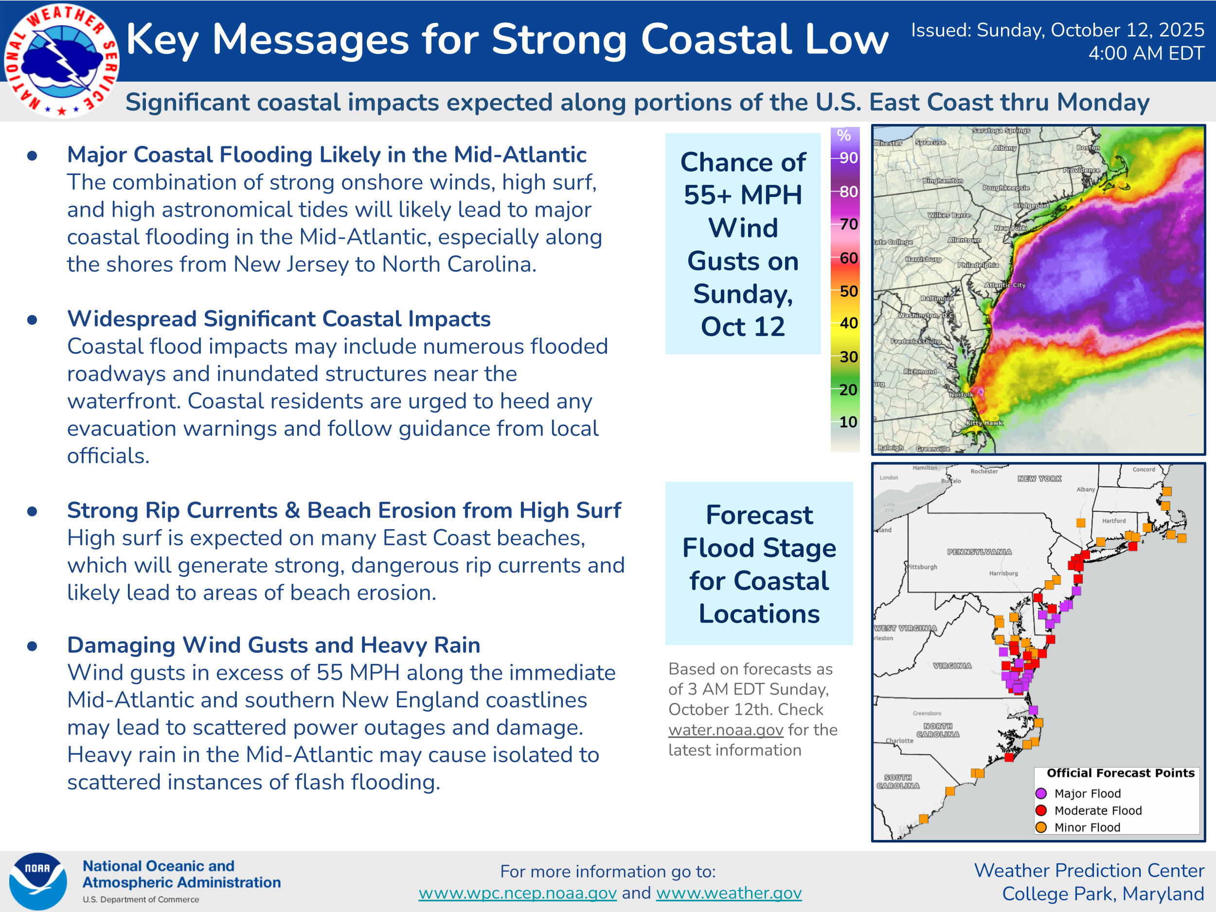
While how much low pressure development of any sort occurs farther north will impact the details as far as specific timing and magnitude of impacts, the overall idea of widespread, significant coastal impacts from the Carolinas north into southern New England through early next week still looks on track, with the maximum impacts in the Delmarva and southern New Jersey. Strong winds, major coastal flooding, serious beach erosion, strong rip currents and heavy rainfall all look likely. Winds look to peak out today while the three high tide cycles over the next 30 hours look to see the worst of the coastal flooding.
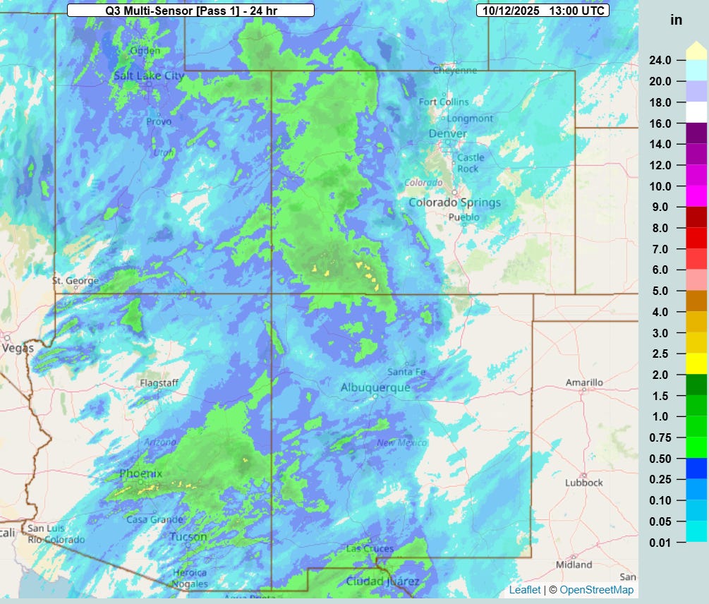
In the West, a slow moving upper level low along the West Coast and tropical moisture from tropical storms Priscilla and Raymond continued to bring widespread rain and thunderstorms to the region over the last 24 hours. Overnight and into this morning, thunderstorms have been moving through the parts of the Phoenix metro area resulting in significant flash flooding with water rescues reported. Meanwhile, heavy rainfall of greater than 2 inches caused flash flooding in southwest Colorado where hundreds of people were evacuated from their homes in La Plata County.

This weather system will continue to produce thunderstorms with heavy rainfall over parts of the desert Southwest today, with the greatest risk of additional flash flooding across southern Arizona and southwest New Mexico.

On Monday, a new and intense upper level low pressure center will drop south along the West Coast, which will spread rain and some heavy mountain snows across much of the western United States. Winter storm warnings are in effect for the higher elevations of the Sierra Nevada as well as the northern Rockies in Montana. Additional flash flooding concerns are anticipated in Arizona, southwest New Mexico and southwest Colorado.
We have talked a lot about extreme levels of moisture this year, and record moisture is helping to fuel the ongoing flash flooding in the Southwest. I pointed out on Friday the record breaking precipitable water values observed on upper air balloon data from Tucson. This morning, I wanted to highlight this Bluesky thread from colleague Brian McNoldy discussing another aspect of the record breaking moisture in the Southwest as seen in the dewpoint values at Albuquerque. Brian noted that with a 60F dewpoint this morning, Albuquerque was seeing their highest dewpoint ever between the dates of October 12 and May 24, and that today is the third consecutive day with a record high dewpoint at that location.
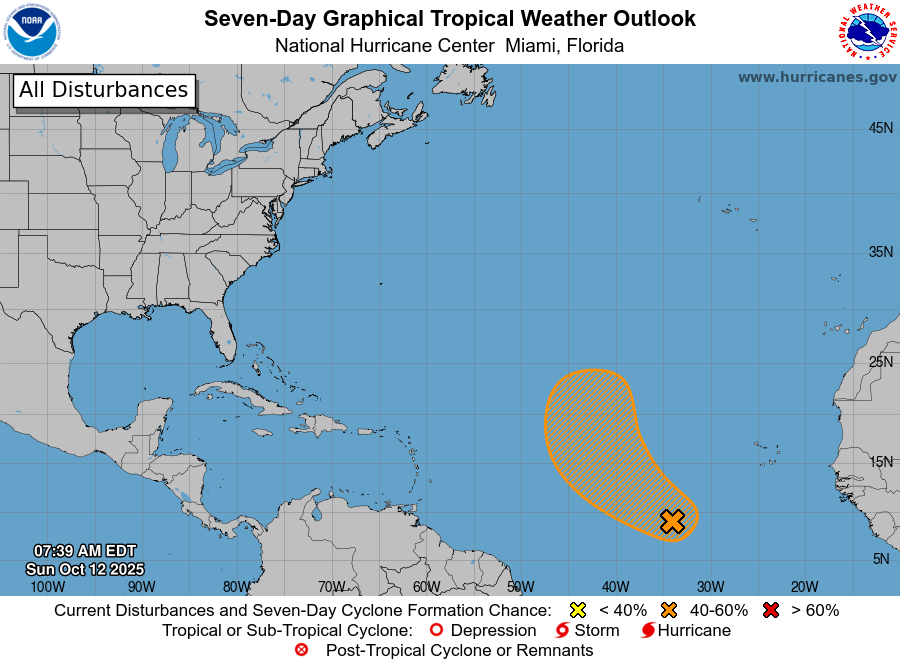
In the Atlantic tropics, Tropical Storm Jerry has dissipated, although it is still producing quite a bit of thunderstorm activity south of Bermuda. The new area of interest in the eastern Atlantic that NHC identified yesterday has now been designated as Invest 97L, and the models have become much more bullish on its development over the next few days. It seems likely that it will in fact become a tropical storm at some point (Lorenzo is the next name on the list), but in the continuing theme of 2025 it should be a recurving storm well east in the North Atlantic.

Leave a comment