Remnants of Typhoon Halong produce hurricane force winds and push massive storm surge inland in Kuskokwim River Delta, destroying and carrying away homes, leaving devastated communities.
Today is Monday, which usually means a tropical deep dive newsletter, but given the catastrophic event that unfolded in Alaska over the last 36 hours, I am going to defer the tropical update and focus today on what transpired in the 49th state with Typhoon Halong.
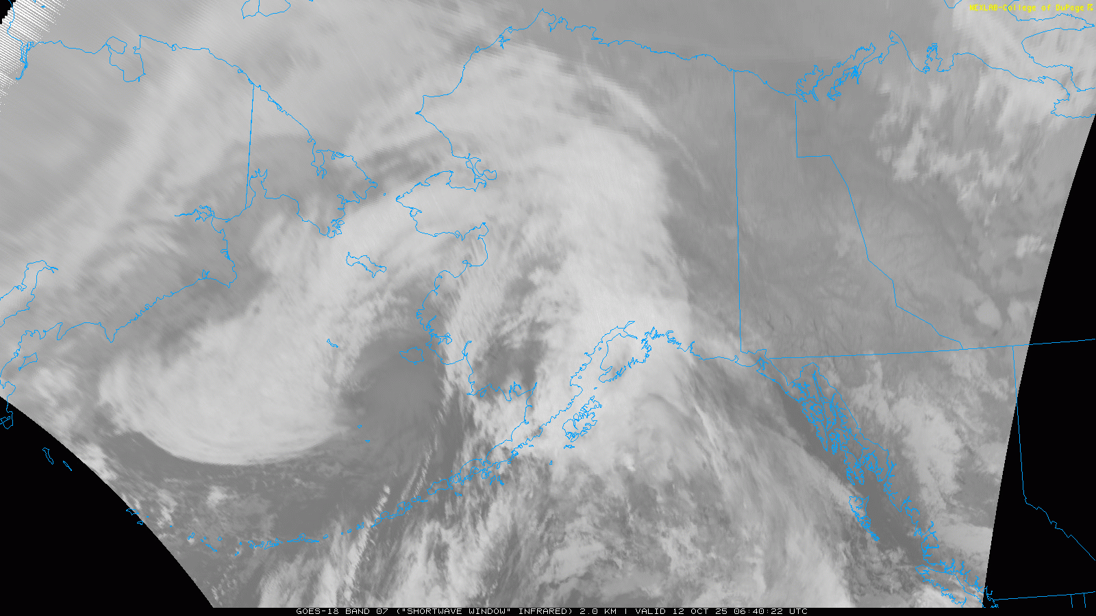
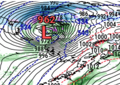
In my Friday newsletter, I talked in detail about the forecast for Typhoon Halong as it moved north toward Alaska, how the models tend to struggle with these systems both as far as potential impacts to Alaska and downstream impacts to the weather pattern over North America, and how missing upper air flights in Alaska might be a further concern for forecasts for systems like Halong. On Sunday, the intense low pressure system that evolved out of Typhoon Halong moved through the Bering Sea and across western and northwestern Alaska as can be seen in the satellite loop above.
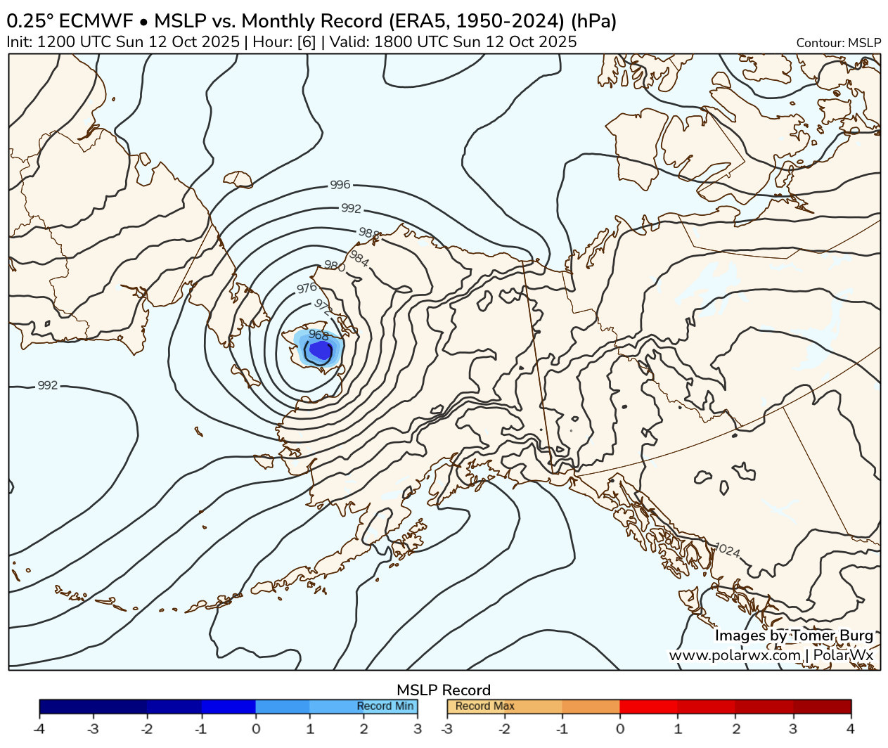
Meteorologist Tomer Burg (link to his wonderful website) posted this map last night showing that this intense low pressure system (central pressure around 967 millibars or 28.55”) set a record for the lowest pressure in the month of October for this region (1950-2024 period of record). Intense winds on the east side of this low swept across western Alaska, with gusts of 107 mph observed at Kusilvak (a USARRAY site) and 100 mph at an FAA observation site at Toksook Bay. The winds caused damage to buildings, trees (where they exist away from the coast) and power infrastructure.
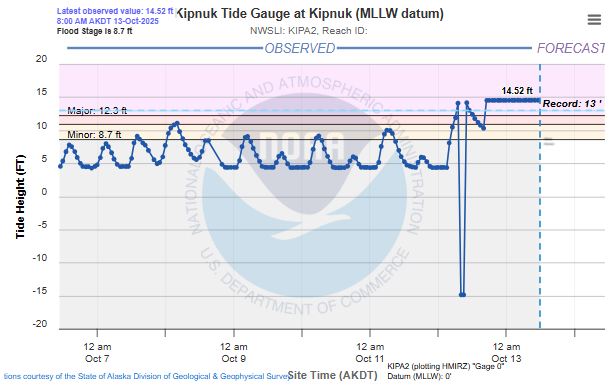
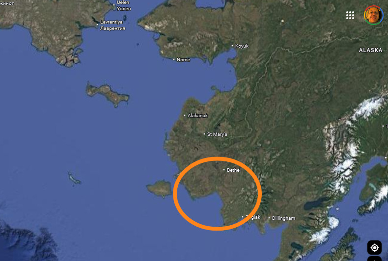
The storm system also generated a massive storm surge that was focused on the Kuskokwim River Delta. The tidal gage at Kipnuk at the mouth of the river reported its highest level on record with a value of at least 14.52’ (the stuck value in the last several hours suggests a possible issue with the gage). Long-time Alaskan meteorologist and climatologist Rick Thoman told me on BlueSky last night that he believes that the crest record for this site is based on post-event high water mark surveys, with the actual gage having only been in place since 2022. Regardless of the details in the historical data, he told me that it was clear “this is a coastal flooding disaster of unprecedented proportions at Kipnuk, and probably at Kwigillingok,” a community along the coast east of Kipnuk.
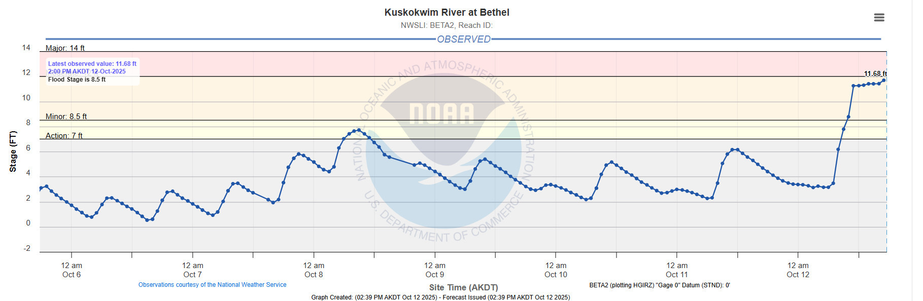
The storm surge pushed water well inland across the region, with the river gage on the Kuskokwim River at Bethel (above) reaching its highest stage this century due to the surge. Bethel is along the river about 40 to 50 miles from the river’s mouth. This inland penetration of water in the flat delta land resulted in the inundation of communities well inland such as Chefornak and Napakiak.
Reports indicate that numerous homes were washed away by the surge, with some carried upriver with people still in them. Alaskan authorities executed immediate search and rescue operations, and more than 30 people have reportedly been rescued. Per the Associated Press, state law enforcement and emergency management are working with local officials to determine how many might still be missing.

With regard to the forecast, in a story for Alaska Public Radio, Rick Thoman noted that the low pressure center moved on a track farther east than anticipated. Indeed, if we look at the model forecasts from as early as last Thursday verifying at the time of the map produced by Tomer Burg above, we can see that the models (European shown above as an example, but a quick look at other models appeared similar) showed an even more intense low but well to the southwest of where it actually verified.
While the model forecasts for the low trended farther east and weaker, even as late as Saturday (Saturday morning European model forecast verifying at 1800 UTC Sunday shown above) they were still a bit too intense and too far southwest. Whether and how much the missing upper air data from western Alaska I discussed in Friday’s newsletter may have impacted these model forecasts is impossible to say without a detailed scientific analysis, but as I mentioned Friday — it certainly cannot have helped.
Even though the low ended up a bit weaker than forecast, the NWS office in Anchorage in their forecast discussions talked about how the winds would still be incredibly strong and greater than hurricane force with the system given the rapidly intensifying low pressure center. While I am by no means an expert on Alaskan coastal flooding, it seems pretty clear that a farther east track of the remnants of Halong meant that the most intense winds on the southeast side of the low were funneled into Kuskokwim Bay and up the river delta, resulting in a massive surge event. NWS forecasts adjusted for the shifts in forecast track and certainly a major storm surge flood event for this region was being forecast by NWS Anchorage leading up to the event.
However, like storm surge events anywhere, the exact track and intensity of the low is key in forecasting the exact timing, magnitude and impact of the event. Rick Thoman noted to me that unlike in a similar event with ex-typhoon Merbok in 2022, the global models overall handled the forecast for Halong very poorly. The track was also very unusual for an intense autumn low pressure system, making the forecast all the more challenging. Again, how much the forecasts might have been improved with pre-2025 levels of upper air data over western Alaska is unknown — but it seems to me like this is one of the clearest possible examples to date where missing upper air soundings due to NWS constraints may have led to a degraded forecast.
Rick Thoman told me this morning that while the numbers of people — several hundred — impacted by this event may seem small on the scale of a Lower 48 damage, for these remote communities, this is a true catastrophe.
The communities impacted are all remote. No road access: fly, boat or in the winter snow machine. Almost all infrastructure single point of failure. There are no electric grids connecting communities. Some do not have running water. It’s too late in the season for any significant rebuilding: winter is bearing down and freeze-up will start soon. For all the severely impacted communities, unless vulnerable people fly out a day or more ahead of time, which was done for this storm at Shaktoolik, the only “evacuation” possible is shelter-in-place, usually in the school, which typically is the most robust structure in town.
If you would like to help our fellow citizens in their time of great need, I have been assured by Rick and others that the Alaska Community Foundation is a great option.
I will have more on the Southwest flash flooding, the East Coast storm and the tropics in posts later today and/or Tuesday. Thanks very much to my colleague Rick Thoman in Alaska for his help with this post.

Leave a comment