Weatherwise: More flooding in southwest Colorado, but a trend toward a few quieter days in store
Oct 14, 2025
With the federal government shutdown entering its third week, USA Today published an article this morning about stresses on the Federal Aviation Administration’s (FAA) Air Traffic Control (ATC) due to the shutdown. This is a topic that has been on my mind a lot since last week when a flight I was on aborted its landing at St. Louis Lambert International Airport a few minutes before we would have been touching down.
I have been on a couple of flights before where the pilots had to execute a “go-around” but those instances were clearly weather related. The weather was perfect in St. Louis, so I was surprised when I could sense that the pilot had aborted the landing when we were still a few miles from the airport — we started to climb a little again and he was clearly turning for a go around. A couple of minutes later, the captain came on the cabin loud speaker and explained that the airspace over STL was very busy, and that out of an abundance of caution they had decided to circle around.
This seemed odd, and I definitely wondered if it had anything to do with the ATC staffing issues that media reports indicate have worsened with the shutdown. Obviously, I will never know for sure, but this morning’s USA Today article brought the issue back to my mind. They reported that yesterday Austin airport had a ground stop due to staffing shortages and last week Burbank’s tower was closed for several hours. “The agency has had long-standing issues with staffing, but they have been compounded by the government shutdown.”

I cannot help but note the corollary between the FAA ATC staffing situation and that being experienced by the NWS, which was also already in a staffing bind that has been made significantly worse by staffing reductions earlier this year implemented by the Department of Government Efficiency (DOGE) and the Office of Personnel Management (OPM). The map above from USA Today shows the staffing levels at the more than 300 ATC facilities operated by the FAA, and as you can see the staffing levels vary greatly among the various sites — again, very similar to what the NWS is dealing with in its more than 120 Weather Forecast Offices.
The USA Today article goes on to say while there have been staffing related delays, the bulk of flight delays in the last two weeks have actually been due to weather, which is of course the most frequent cause of flight delays. Given the critical importance that weather plays in the efficiency and safety of the national air space, the partnership between the NWS and FAA is a crucial piece of the puzzle for air travel in this country.

In order to better support the FAA ATC system, the NWS operates small field offices known as Center Weather Service Units (CWSU) based at each of the FAA’s Air Route Traffic Control Centers (ARTCC) to provide direct weather support services to the air traffic controllers in those facilities. These offices also support the towers and other FAA ATC facilities within the area of responsibility for their collocated ARTCC. Each CWSU has a target staffing of four NWS meteorologists: a meteorologist-in-charge and 3 forecasters. These 4 meteorologists typically provide services to their FAA counterparts 16 hours a day, 7 days a week. The NWS also operates a slightly larger (6 meteorologists) co-located unit at the FAA’s national Air Traffic Control System Command Center (ATCSCC) in Warrenton, VA.
Various reports over the years have shown the importance of CWSUs as the on-site meteorologists and their support can be well-integrated into the operations of each ARTCC. However, obviously with only 4 meteorologists, any staffing shortage can be a serious concern. In a recently released memo dated August 28th of this year and addressed to the Secretaries of Transportation and Commerce — the secretaries responsible for the FAA and NWS respectively — the US Government Accountability Office (GAO) outlined its serious concerns about the current and future staffing levels of CWSUs.
CWSUs are operated by the NWS under an interagency agreement (IAA) between the NWS and FAA, in which the FAA reimburses the NWS for the operational costs. Late last year, there were media reports that the agreement was in danger of being terminated by the FAA, but at the last minute a reprieve was announced and the interagency agreement was renewed.
Per the GAO memo, the cap for the number of CWSU employees under this new interagency agreement is 81. Obviously, just to fully staff the 21 CWSUs should take 84 meteorologists, and that is not counting the additional several meteorologists at the national command center; the previous IAA had a target of 90, which would be right to fully staff the offices.
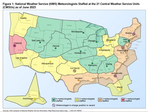
As of June 2025, the actual staffing number was 69, with five offices without meteorologists-in-charge and two vacancies at the national command center. I encourage you to read the entire memo which is a detailed — and concerning — summary of the both the short and long term CWSU staffing situation and GAO’s concerns about the potential impacts to the efficiency and safety of the federal airspace. These paragraphs summarize the short term situation:
NWS officials said that its services to the command center are also reflecting strain from operating with fewer aviation meteorologists; there are currently four meteorologists staffed out of the six meteorologists designated for the command center. Because of the fewer number of aviation meteorologists at the command center, NWS officials told us that meteorologists have sometimes had their workloads doubled as they monitor the daily forecast and work on forecasts for the next day simultaneously. According to the officials, this risks a degradation of the forecast because the meteorologists are working on different tasks simultaneously and their situational awareness is disrupted.
NWS officials told us that they have taken several mitigation actions to continue providing services at CWSUs with fewer meteorologists. One of these actions includes providing backup services from other CWSUs remotely to a CWSU that has staffing vacancies. However, an NWS Instruction states that having a CWSU provide decision support services for another CWSU where a NWS meteorologist is absent during normal hours of operations should be rare and reserved for emergency situations. Other actions NWS officials described include detailing meteorologists from other NWS offices to CWSUs, placing aviation meteorologists from the command center on temporary duty at CWSUs, and using meteorologists from the local weather forecast office to fill in-person shifts at CWSUs.
FAA officials told us that NWS is keeping them informed of these mitigation strategies and that there are no safety or preparedness concerns. However, NWS officials said that meteorologists are taking “heroic measures” to meet the agency’s needs. The association representing meteorologists said the narrow staffing margins have meteorologists stretched unsustainably thin and have created a very stressful working environment. Stakeholders from the four major airlines (for about 76 percent of domestic flights in 2024) and three associations representing airlines, air traffic controllers, and meteorologists expressed concerns about the current meteorologist staffing levels and the mitigation strategies being used, such as providing remote support.
Needless to say, this CWSU staffing situation combined with the ATC staffing situation is very concerning. I am assuming that NWS has continued the mitigation strategies discussed above and potentially implemented additional ones, and my understanding is that a number of CWSU positions were advertised in the recent recruitment effort NWS was able to undertake. However, clearly this CWSU situation is just another staffing hole NWS is trying to plug with all of the other shortfalls it has, and just further reinforces the foolishness of DOGE/OMB significantly reducing the NWS/NOAA meteorologist ranks earlier this year.
We have continued to get lucky with a lack of hurricane landfalls and a mostly manageable wildfire season, but I know from conversations with NWS employees that workload and stress remain very high and now the operational staff (along with other essential employees like ATC and TSA) is dealing with having to work through a shutdown without pay. While we as a public should continue to thank and support these public servants, at some point one has to worry that some sort of breakdown is inevitable — and at that point I hope we remember that these people dedicated to public safety have truly been put in an untenable situation.

Turning quickly to weather, the West continues to be where most of the action is at. The 24 hour estimated rainfall from the Multi-radar Multi-sensor system shows that precipitation has been widespread the last 24 hours across much of California and the southern Rockies.
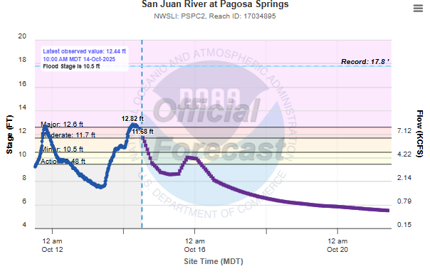
Heavy rainfall of up to 3” in the last 24 hours in southwest Colorado pushed the San Juan River at Pagosa Springs to a slightly higher level than in the serious flooding experienced there over the weekend. This renewed flooding prompted additional evacuations; luckily water levels are starting to fall and local officials are hoping the evacuation orders can be lifted later today.

The system in the West will continue to bring widespread rain and high elevation snows, with flash flooding and isolated severe storms possible in southern California and central New Mexico. Severe thunderstorm and flash flood warnings are in effect late this morning for areas just north of Los Angeles, including the Burbank and Santa Clarita areas.

Overall, a quieter next couple of days is anticipated nationwide as the storm system slowly weakens and moves east. However, the system will get a new influx of upper level energy late in the week which will cause reintensification, and as the storm system moves farther east, some risk of severe weather could evolve by Saturday over parts of the Midwest. There is still quite a bit of uncertainty in exactly how this system will evolve this weekend, so for now it is just something to keep an eye on.
In the tropics, Lorenzo has weakened slightly in the central Atlantic to a 45 mph tropical storm and continues to pose no risk to land, while the longer range ensemble models continue to show some risk for a westward moving system to develop in the Caribbean next week. Again, still a lot of uncertainty here and just something to have in mind for awareness.

Leave a comment