Increasing risk for severe storms across parts of the central US into Saturday
Oct 16, 2025
Starting off this morning by sharing a couple of stories and links I think of are interest.

First, some shameless self-promotion as I want to share this week’s episode of The Weather Channel’s long running Weather Geeks podcast, which in this week’s episode featured me. It was a real pleasure and honor to chat with Dr. Marshall Shepherd for his podcast which is a staple of the weather community. I enjoyed talking with him about NWS history and evolution, as well as the current and future state of weather communication. Give it a listen here.
Yesterday, Andy Revkin shared on his Sustain What Substack a fascinating piece by Professor John “Mike” Wallace of the University of Washington. Dr. Wallace is a longtime climate scientist who early in his career was very skeptical of the potential impacts of global warming and climate change, but who — based on evidence — has come to revise his perspectives and seems to me to have a pragmatic and realistic view of the threats facing our society. As someone who started his own career rather skeptical of the idea that I would see tangible impacts to weather from climate change in my own lifetime, I resonated with his story and found it fascinating. I encourage you to read it for a sense of how a scientist can come to change their perspective if they are truly open to the evidence before them.

Looking at the weather, today will again see the storm system we have been tracking the last several days slowly moving across the center of the country, with scattered rain and storms and some higher mountain snow in the Intermountain West.
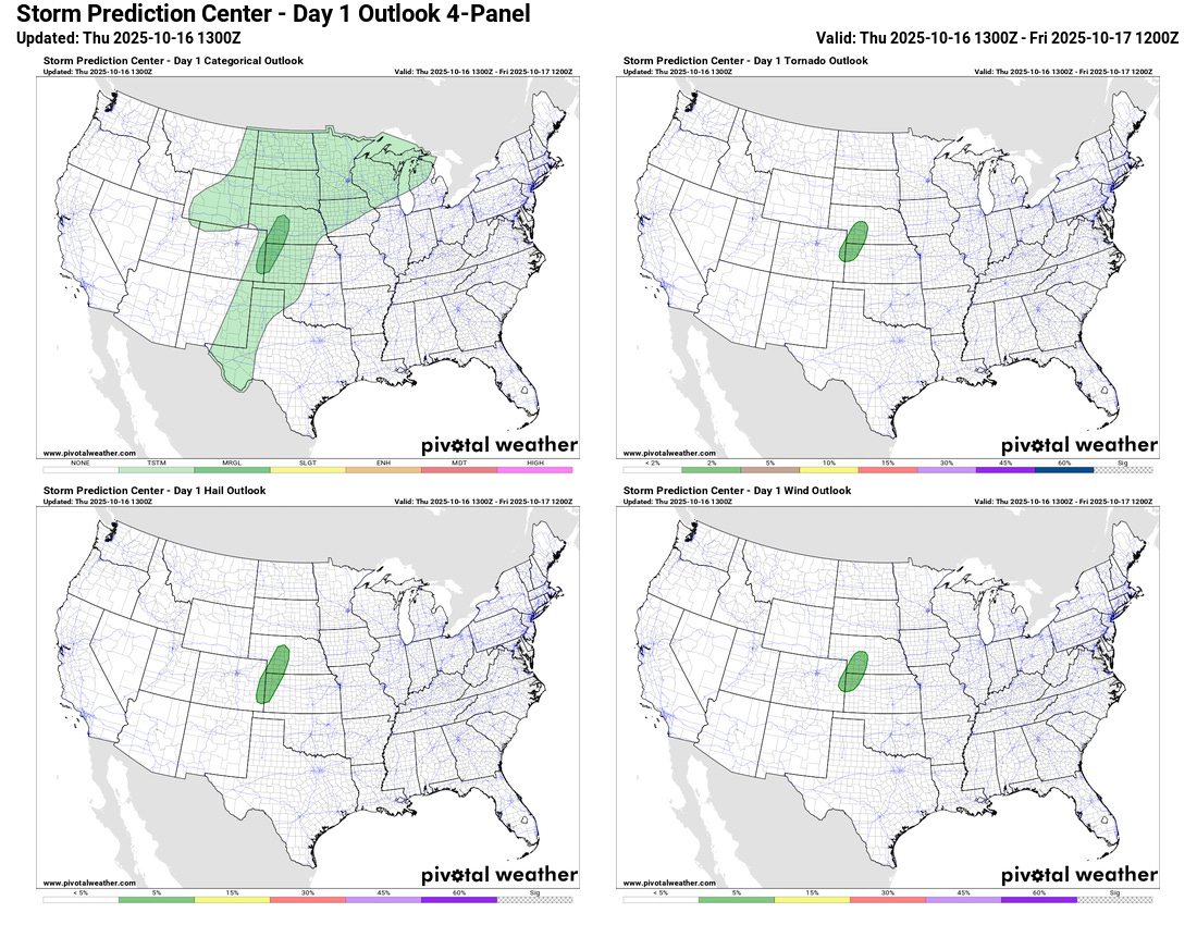
Today will start to see the gradual ramp up in the intensity of thunderstorm activity with this storm system as it restrengthens over the next few days. A few supercell severe thunderstorms are possible in the High Plains of eastern Colorado into central Nebraska, and the Storm Prediction Center (SPC) has a marginal (level 1 of 5) risk in place.
By Friday the marginal risk will shift east into areas from Oklahoma into western Missouri.
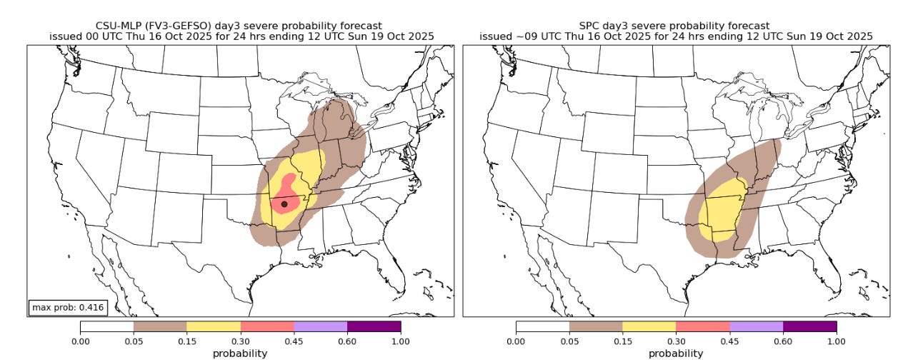
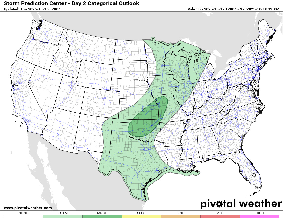
As the storm system continues to intensify on Saturday, a greater risk of severe weather looks to develop over parts of the Mid-South and Mid-Mississippi Valley. The Colorado State University Machine Learning Probabilities (CSU-MLP) system — which I have found to be a quite good tool in the last couple of years — has been trending more bullish with its probabilities for this event as can be seen above (CSU-MLP on the left, day 3 SPC outlook on right). There are still some model discrepancies here to sort out, but given the model trends this will be a system to keep an eye on.
In the tropics, the longer range models continue to show the potential for a westward moving tropical wave to develop next week once it reaches the Caribbean. Still plenty of time to watch this system, but again, we want to keep a close eye on it given that the Caribbean is typically a favorable area for development at this time of year.
Programming note: I will be traveling the next several days on a road trip to and from Florida. As of now, I am planning to keep a relatively typical level of posts going, but will obviously let you know if that changes. I am also planning to make some video posts along the way from the Gulf Coast about hurricanes and particularly Katrina and its recent 20th anniversary. Internet permitting I am planning on some live content — as a reminder, access to live video and chats is a primary benefit of supporting Balanced Weather with a paid subscription.

Leave a comment