And increasing risk for a tropical cyclone in the Caribbean this week
Oct 19, 2025

Yesterday saw one of the first organized severe weather events of the 2025-2026 cool season. A few complexes of severe thunderstorms developed ahead of an intensifying storm system and cold front, with a number of severe wind damage reports and a few instances of hail scattered from the lower Great Lakes into the Arklatex region.
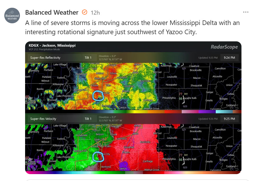
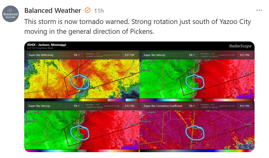
A few tornadoes were reported, one in south-central Arkansas and a couple of more in the lower Mississippi Delta. I talked in my Friday evening post about how the high-resolution models were trending toward a greater tornado risk in the region around Interstate 20 in Louisiana and Mississippi, and late last evening an complex of severe storms with embedded rotation evolved in the Arklamiss Delta. After producing a brief tornado in northeast Louisiana, a new strong circulation developed just southwest of Yazoo City, MS.
The rotation continued to organize over the next few minutes as it moves into the south side of Yazoo City.
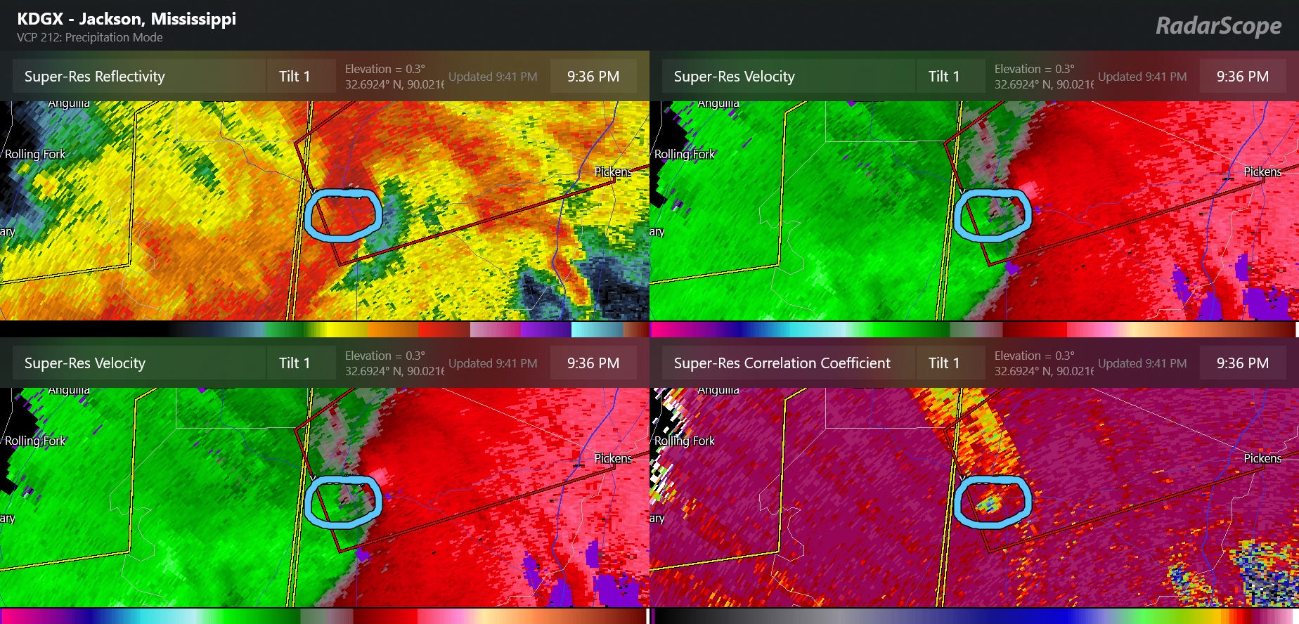
By 9:36 pm, a well developed tornadic debris signature (TDS) was evident in radar data. This can be seen by the lower values of correlation coefficient data in the lower right hand image in the radar four-panel above. Essentially, correlation coefficient is a dual-polarization radar product that discerns the size and shape of what the radar is detecting. When a tornado lofts debris into the atmosphere and the radar detects it, we see low correlation coefficient values because the radar targets are of varied size and shape. While I have not seen any damage reports yet from this tornado and this did not appear to be an intense tornado, given the fairly well defined TDS I would guess there is a decent path of damage on the south side of Yazoo City.
When I posted about this last night, a couple of people replied to me that it’s “always Yazoo City.” In fact, the Yazoo City area has been hit by multiple tornadoes in recent years, the most infamous being the huge, long tracked wedge tornado in April 2010 that went through the same general area as last night’s tornado. I have always been fascinated by the way severe storm complexes evolve in the lower Delta region, and cannot tell you how many times in my 30 years of monitoring severe storms in this area that I have seen an evolution very similar to what occurred last evening.
The Mississippi Delta is bounded on its east side by a relatively sharp (for the flat terrain) line of bluffs. I have long suspected that the way storms evolve to have more rotation in this specific area of the lower Delta might be related to those bluffs. During the Propagation, Evolution and Rotation in Linear Storms (PERiLS) field project in VORTEX-Southeast, National Severe Storms Laboratory and University of Oklahoma scientists used advanced observational technology to study the effects of the terrain on severe storms in this region, and in a paper published in Monthly Weather Review summarized their findings that the PERiLS data suggests an influence in tornado frequency due to the terrain and potential physical reasons why this could be happening.
This is incredibly important research not only in that it could help NWS forecasters improve tornado warnings for this specific area, but it also demonstrates the potential impact of local terrain features on tornado climatologies in other parts of the country. I would be remiss if I did not point out that it is this exact sort of research that is in significant jeopardy to the the President’s plans to eliminate the Office of Oceanic Research and significantly reduce research funding to NOAA and the National Science Foundation, which jointly supported PERiLS.
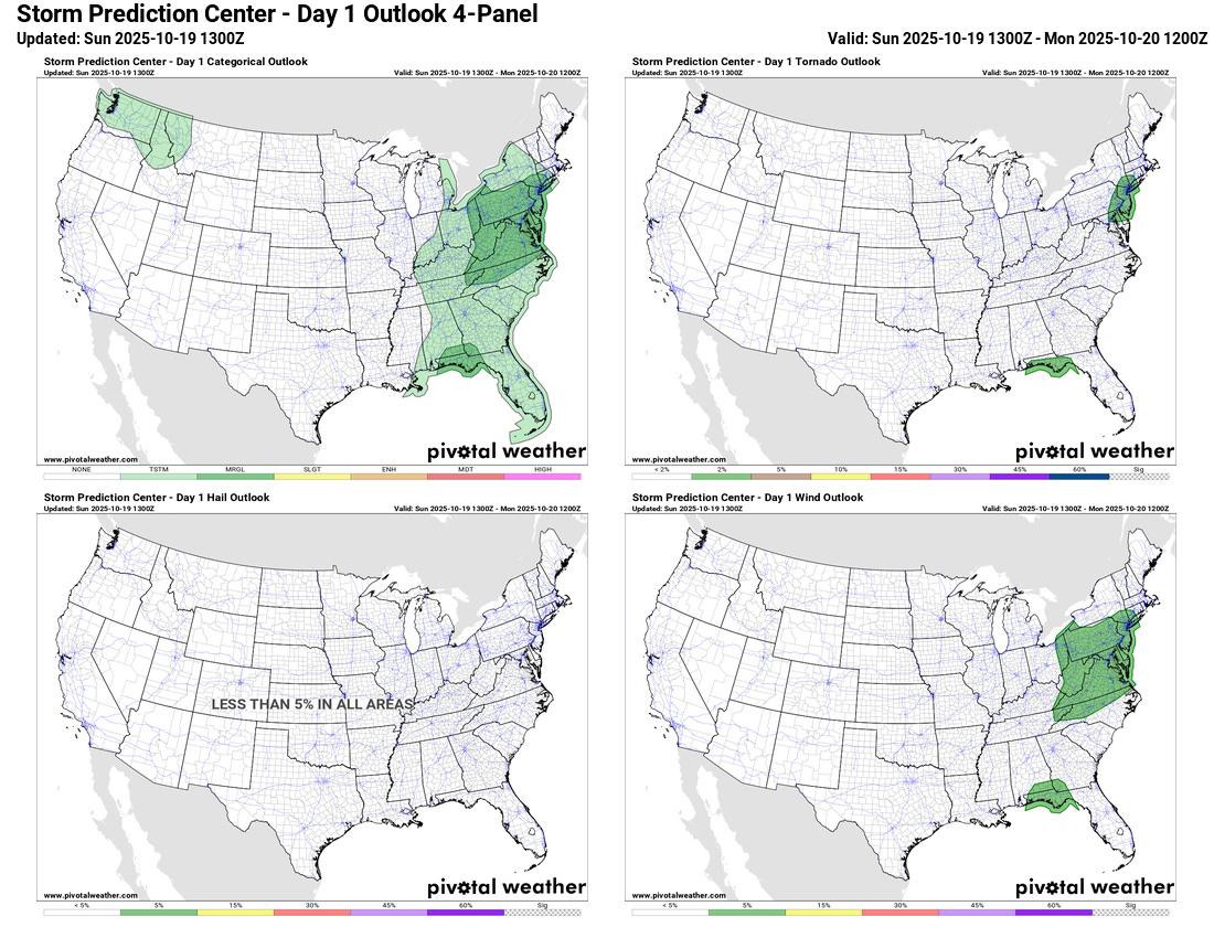
As far as additional severe weather potential today, as the strong storm system continues to move slowly east, a band of strong to occasionally severe storms is expected to sweep across the eastern United States. Damaging winds and a couple of tornadoes are possible with the line, and the Storm Prediction Center has a marginal (level 1 of 5) risk in the Mid-Atlantic and upper Ohio Valley for this risk. A separate complex of storms along the Gulf Coast is also covered with a marginal risk.
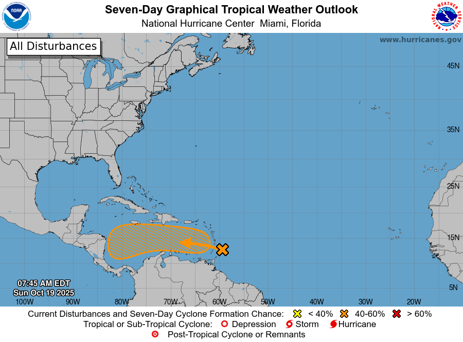
In the tropics, the National Hurricane Center has increased the risk of development with the tropical wave moving through the eastern Caribbean islands to 60%, and the overall trends in the models and observational data suggest a tropical depression or storm will likely develop here sometime in the upcoming week. As far as longer term intensity or track, that still seems quite uncertain with a number of potential scenarios.
However, the general idea seems to be that a faster developing, more intense system would be more likely to move north and northeast out of the Caribbean and into the north Atlantic later this week and early next week. Meanwhile, a slower developing system would likely drift around in the western and central Caribbean for a number of days — but could eventually become quite strong in the western Caribbean next week. Right now, the physical based models such as the European ensemble are strongly leaning toward the latter solution, while the AI Google DeepMind and European AI systems are split between the two main scenarios. Obviously, we’ll be watching closely this week.
Programming Note: I will be traveling the next several days on a road trip to and from Florida. As of now, I am planning to keep a relatively typical level of posts going, but there will likely be some delays and posts at unusual times.

Leave a comment