TS Melissa slowly organizing in the Caribbean, increasingly likely to be a major hurricane by this weekend
Oct 22, 2025
Before I get into what is happening with Tropical Storm Melissa and other US weather happenings, I want to take a few minutes to talk about another weather event that is getting global attention. On Monday afternoon, a tornado struck the Paris suburb of Ermont, causing three cranes at a construction site to collapse, damaging a number of homes and flipping vehicles. A 23 year-old worker was killed at the construction site and nine other people were injured, four seriously. A number of people were left without homes.
When I mentioned this event to a couple of people yesterday, they said “I didn’t know they had tornadoes in Europe.” While the frequency of tornadoes in Europe is not nearly as great as in the United States, they definitely do get tornadoes. The European Severe Storms Laboratory (ESSL) is an organization of a number of European governmental meteorological agencies and private sector partners with the mission of improving understanding of European severe thunderstorm and tornadoes, and providing training to forecasters to improve public information about these risks.
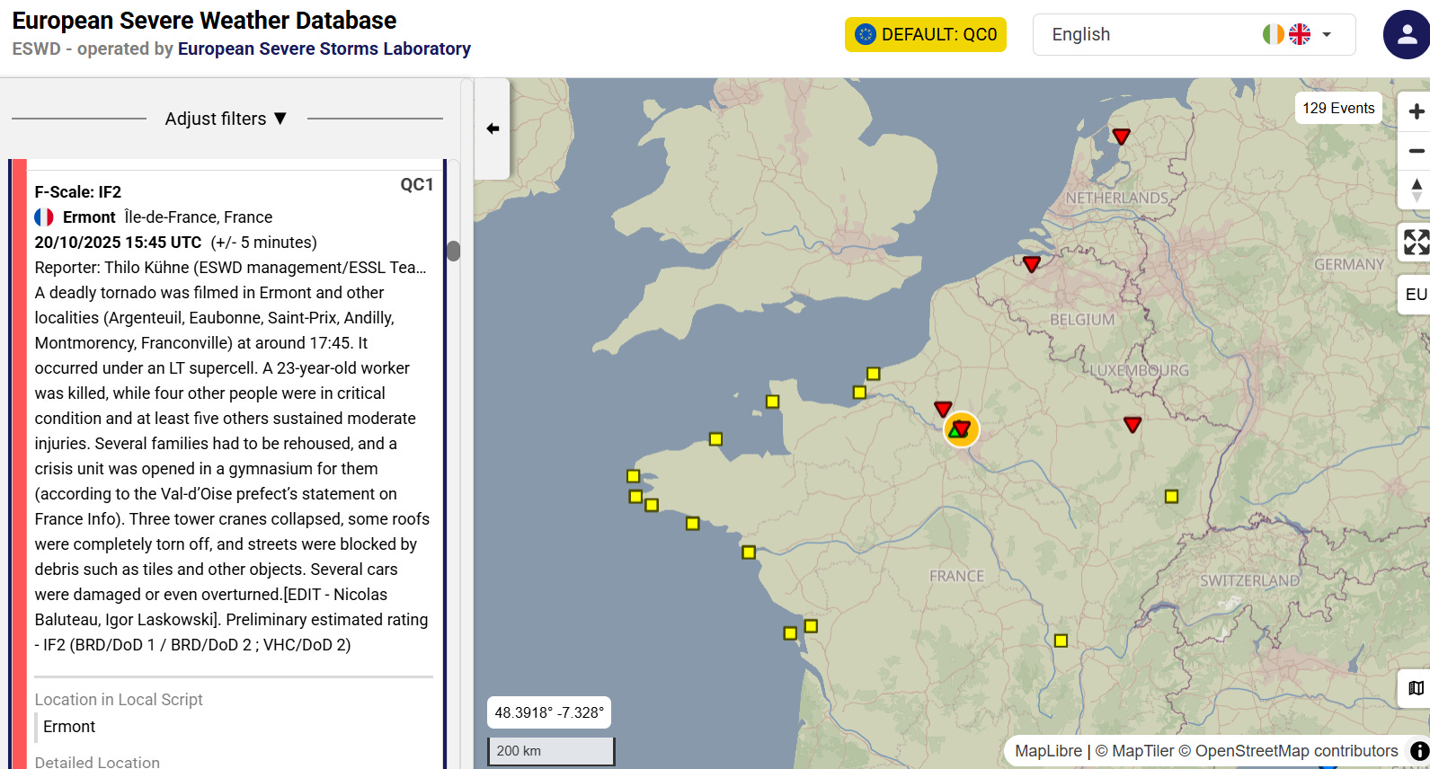
One of the key projects of ESSL is to maintain the European Severe Weather Database (ESWD) with the goal of providing the public with a quality controlled database of severe thunderstorm and tornado events in Europe. The above screenshot is from the ESWD’s entry for Monday’s tornado near Paris, which has been preliminarily rated an IF2. “IF” stands for International Fujita Scale, a modified version of the Fujita scale to allow for improved damage ratings in Europe. An IF2 tornado has estimated instantaneous speeds of 220 to 249 km/h, or 137 to 155 mph. (The Enhanced Fujita estimated wind speeds are 3-second gusts not instantaneous winds, so there is not a one to one comparison between the two scales as far as windspeeds.)
One of the important roles the ESWD serves is to be able to better understand how the risk of severe thunderstorms and tornadoes is evolving in Europe due to climate change. In this BBC article, ESSL director Pieter Groenemeijer notes that indications are that climate change is leading to more severe storms in Europe — but obviously in order to scientifically monitor such change, you need accurate data on the incidences of these events. As of now, ESSL estimates that about 300 tornadoes occur over land in Europe annually (waterspouts are more common), in comparison to about 1,000 tornadoes in the United States (similar land size, Europe slightly larger).
Due to the less frequent risk from severe thunderstorms, in general Europe has not had nearly as robust warning and forecast services as the United States, but obviously ESSL is working to improve those services. If the risk continues to grow in Europe due to climate change, one would expect that the need for these services will grow as well.
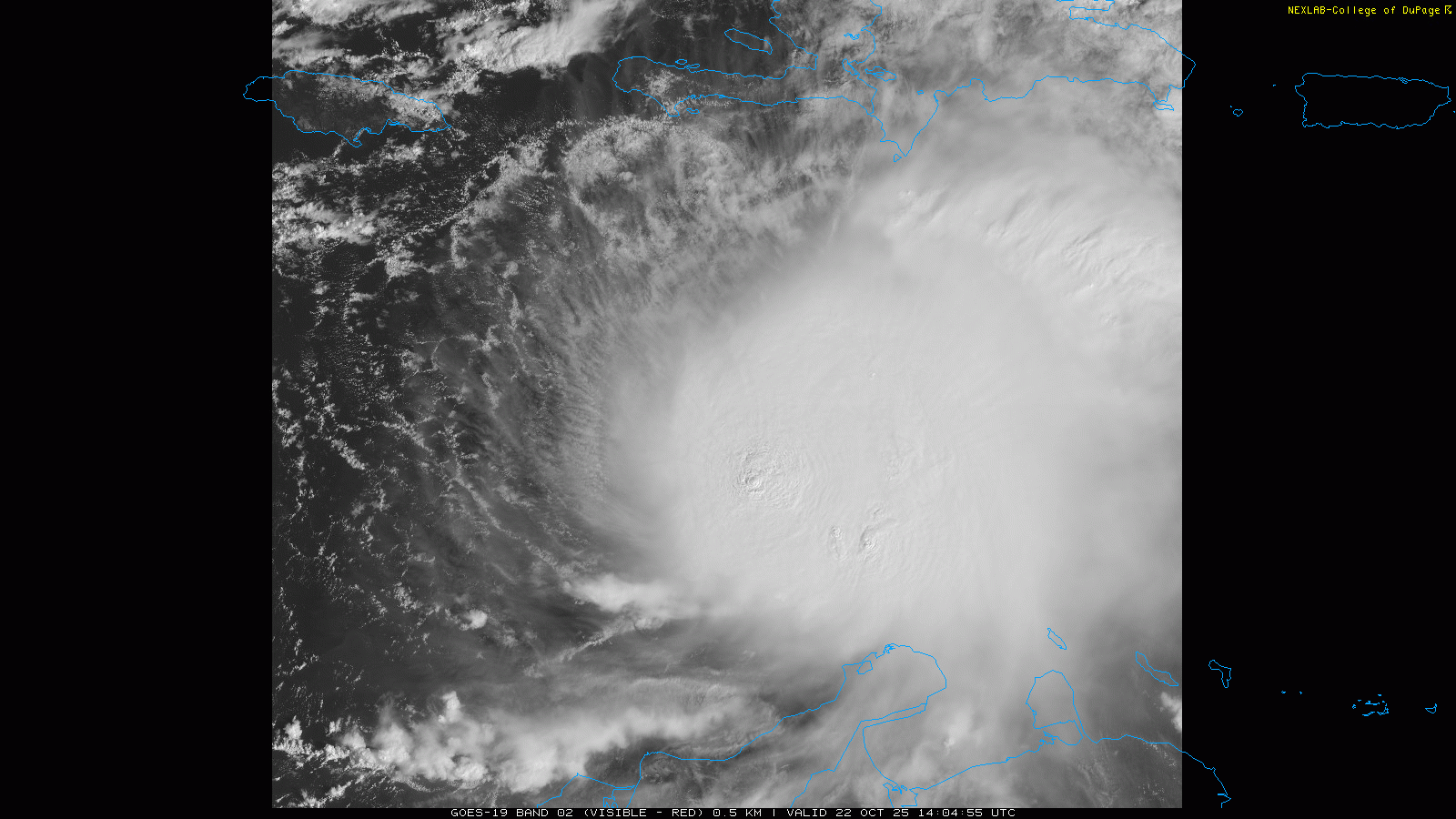
Turning to the tropics, morning visible satellite imagery shows that Tropical Storm Melissa is very gradually getting better organized as it very slowly drifts west. A US Air Forecast reconnaissance aircraft is in the storm this morning, and is finding that the system is holding its own as far as intensity, with maximum sustained winds of 50 mph. Satellite imagery suggests that Melissa is still dealing with west-northwest wind shear as most of the thunderstorm activity is still east of the center, and reconnaissance data shows that the circulation of Melissa is significantly tilted with height which also indicates the presence of shear. However, that wind shear may be lessening slightly as recently the storms have been developing closer to the center than 24 hours ago.
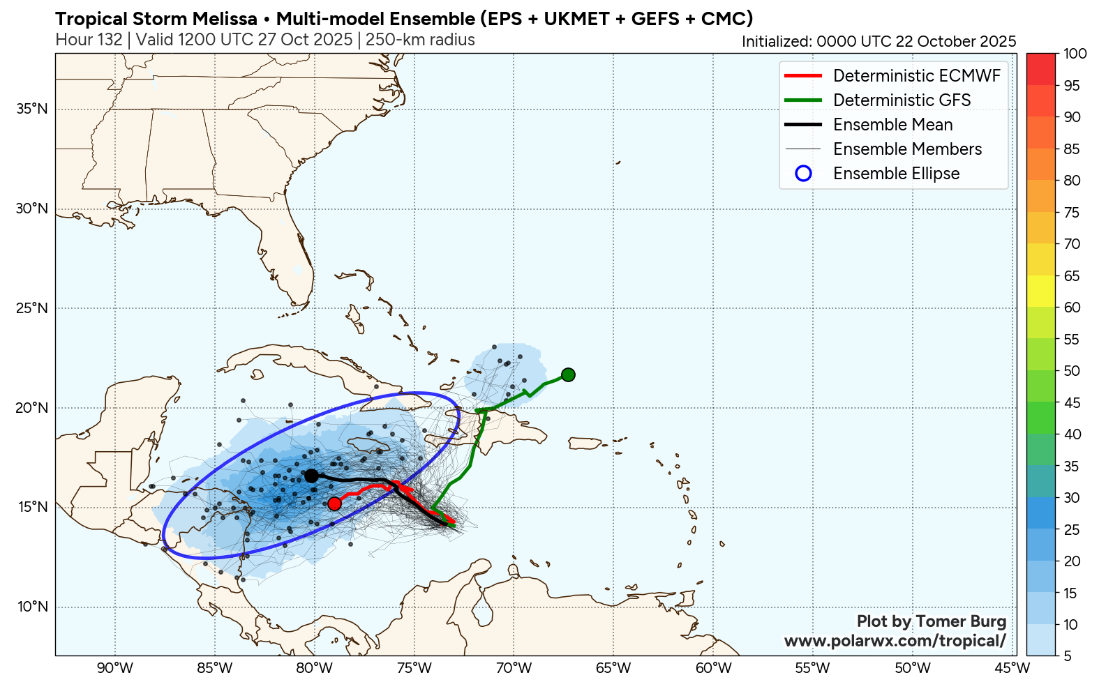
While there is still plenty of uncertainty in the track forecast, overall the models appear to be trending a bit more toward the idea of a system moving slowly to the west over the next several days, with Melissa eventually moving north-northeast out of the Caribbean and into the north Atlantic in about a week or so. This makes sense given the slower organization and intensification trend of the system. However, the operational US global model and a significant number of the AI based ensemble forecasts still show a quicker intensifying system moving more to the northeast across Hispaniola over the next few days — so we will want to keep an eye on any observational trends toward more rapid intensification.
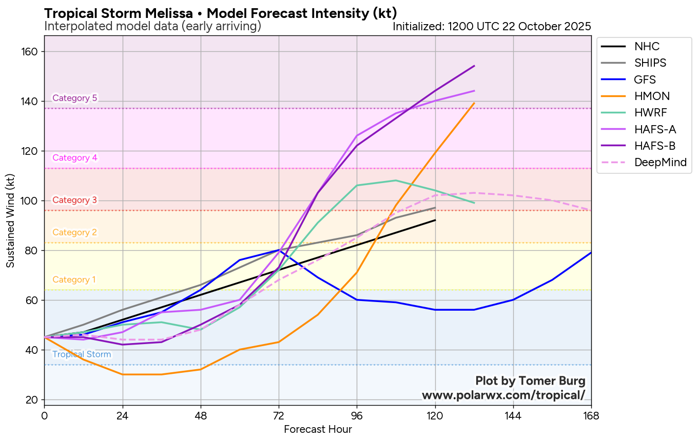
Ironically, the slower organization of Melissa will likely mean an eventual significantly higher ceiling for the intensity of the storm. The SHIPS model shows the wind shear dramatically weakening to almost zero over the next 48 to 72 hours, and in response most of the better intensity and hurricane models make Melissa a major hurricane by this weekend, and the most recent NHC forecast shows Melissa becoming a category 3 hurricane. In fact, you can see in the forecast intensity graphic above that three of the hurricane-specific forecast models — HMON and the two HAFS models — forecast Melissa to become a category 5 hurricane.
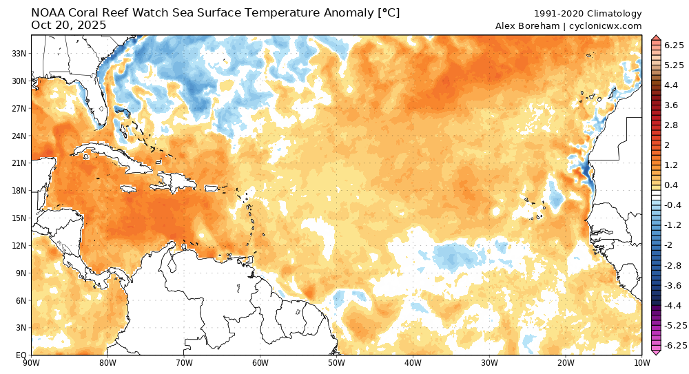
The water temperature of the central and western Caribbean is much above normal, and highly suggestive of rapid intensification given other favorable parameters, which look to as if they will become more supportive over the next few days. SHIPS already shows the probability of rapid intensification over the next 72 hours to be 5 times normal, and conditions are only expected to become more favorable with time. Climatologically speaking, this region has produced many major hurricanes in October historically. Bottom line — while there still exists quite a bit of uncertainty with Melissa, the potential for a category 3+ hurricane in the western Caribbean this week has become rather high, and people living in or with interests in Cuba, Jamaica, Hispaniola and the Bahamas should be monitoring forecasts closely and undertaking preparations as advised by local authorities.
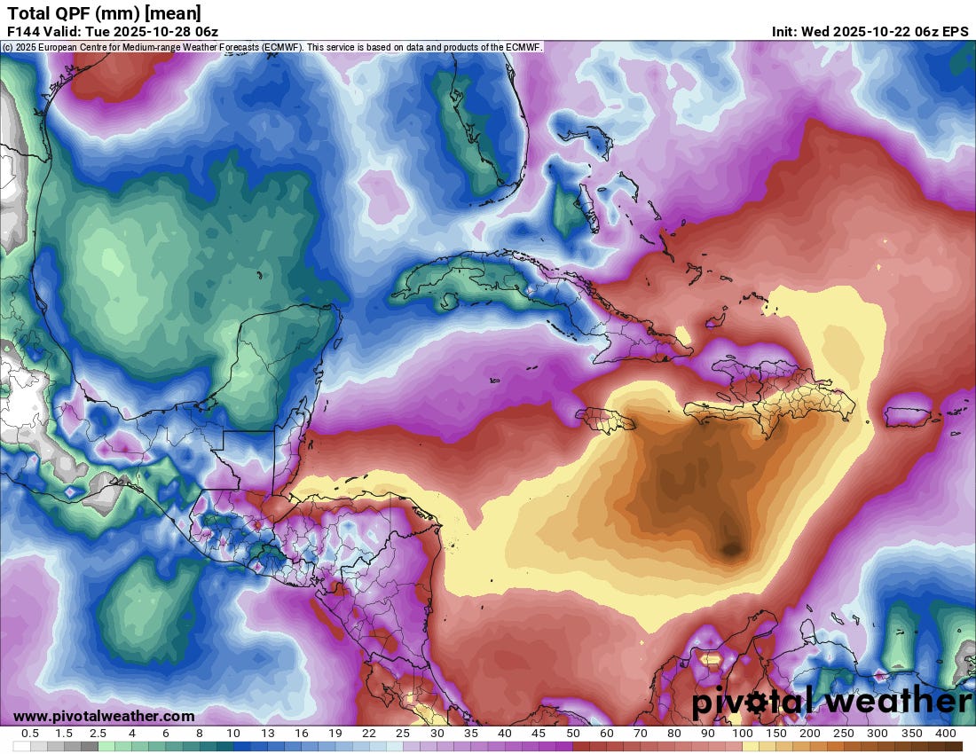
The threat of extremely heavy rainfall and potentially disastrous flash flooding also continues to increase for Jamaica and Hispaniola. The above is the 6 day rainfall forecast from the most recent European ensemble model, with amounts of up to 15” in these islands. Given the terrain, this would certainly result in a serious risk of flash floods and mudslides. It is important to note that more rain would likely occur beyond this time and expand to include Cuba and the Bahamas depending on when and where Melissa moves and starts to lift north-northeast out of the Caribbean.
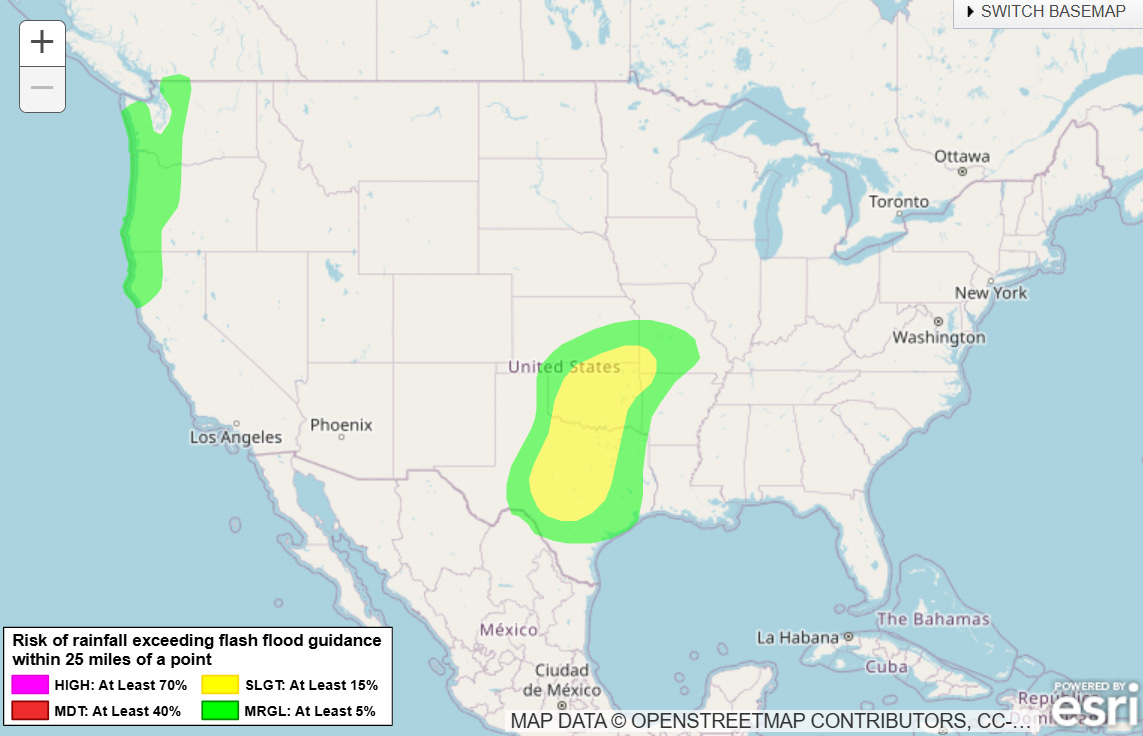
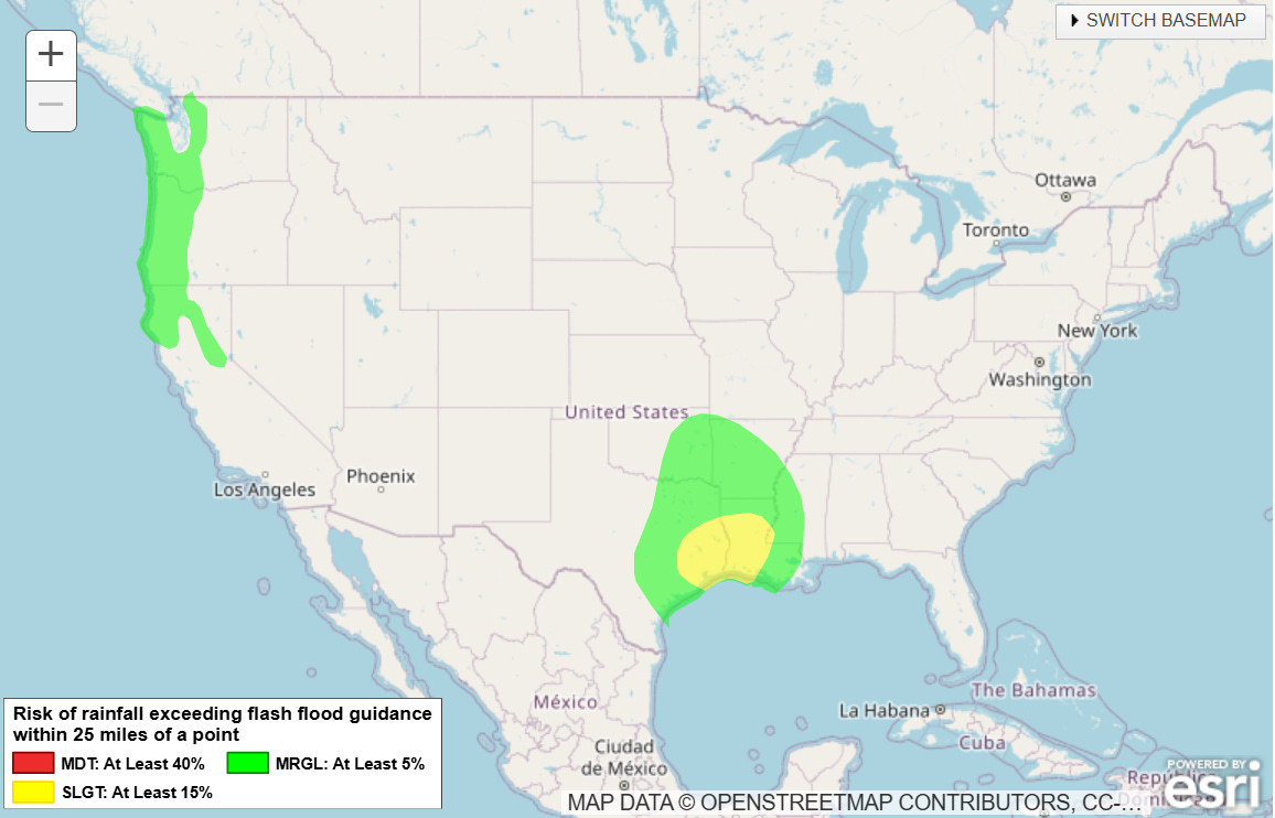
The first in a series of upper level weather systems moving across the southern United States that will help to eventually change the steering flow to allow Melissa to move north-northeast will bring a risk of thunderstorms with heavy rainfall and flash flooding on Friday (top map above) and Saturday (bottom map above). A few severe thunderstorms are also possible in these regions as well.

Leave a comment