Potentially catastrophic impacts anticipated for parts of the Caribbean, with increasing risk to the Bahamas
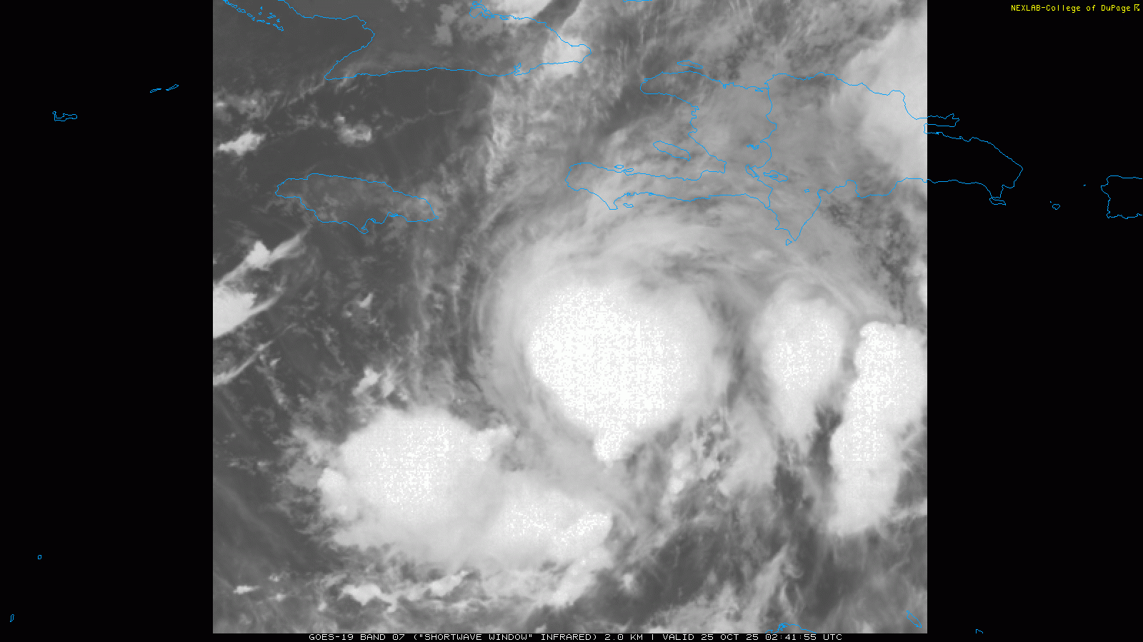
Good evening — I was traveling most of today, and will be traveling again most of tomorrow, so I wanted to get at least a quick update out about Tropical Storm Melissa. To be honest, not that much has changed as far as the anticipated forecast or impacts from what I talked about 24 hours ago. As expected, Melissa has gotten somewhat better organized today, but reconnaissance aircraft data this evening indicates the storm is still battling some upper level wind shear. Still, the pressure in the center of the storm has fallen about 10 millibars from 12 hours ago, and the satellite loop above shows thunderstorms continuing to slowly build west from the center of circulation. All of this indicates slowly decreasing wind shear and a gradual improvement in the organization of the storm.
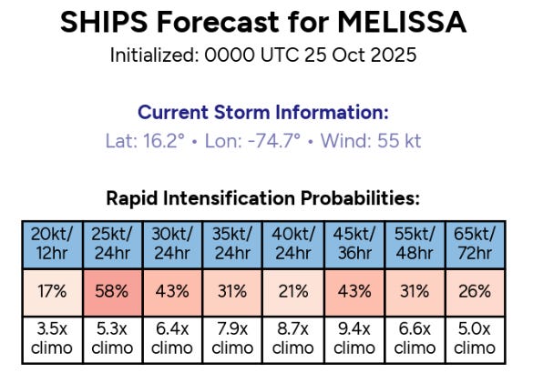
The rapid intensification (RI) probabilities from the most recent version of the SHIPS intensity forecast are some of the highest I have seen in a long time, with values up to 10x higher than normal. As shear continues to gradually decrease to levels more supportive of RI, Melissa should take advantage of the incredibly deep warm water it will be traversing to become a major hurricane by sometime later this weekend. NHC forecasts Melissa to peak at a category 4 hurricane before it starts to interact with land, and some model solutions continue to show the very plausible potential for it to become a category 5.
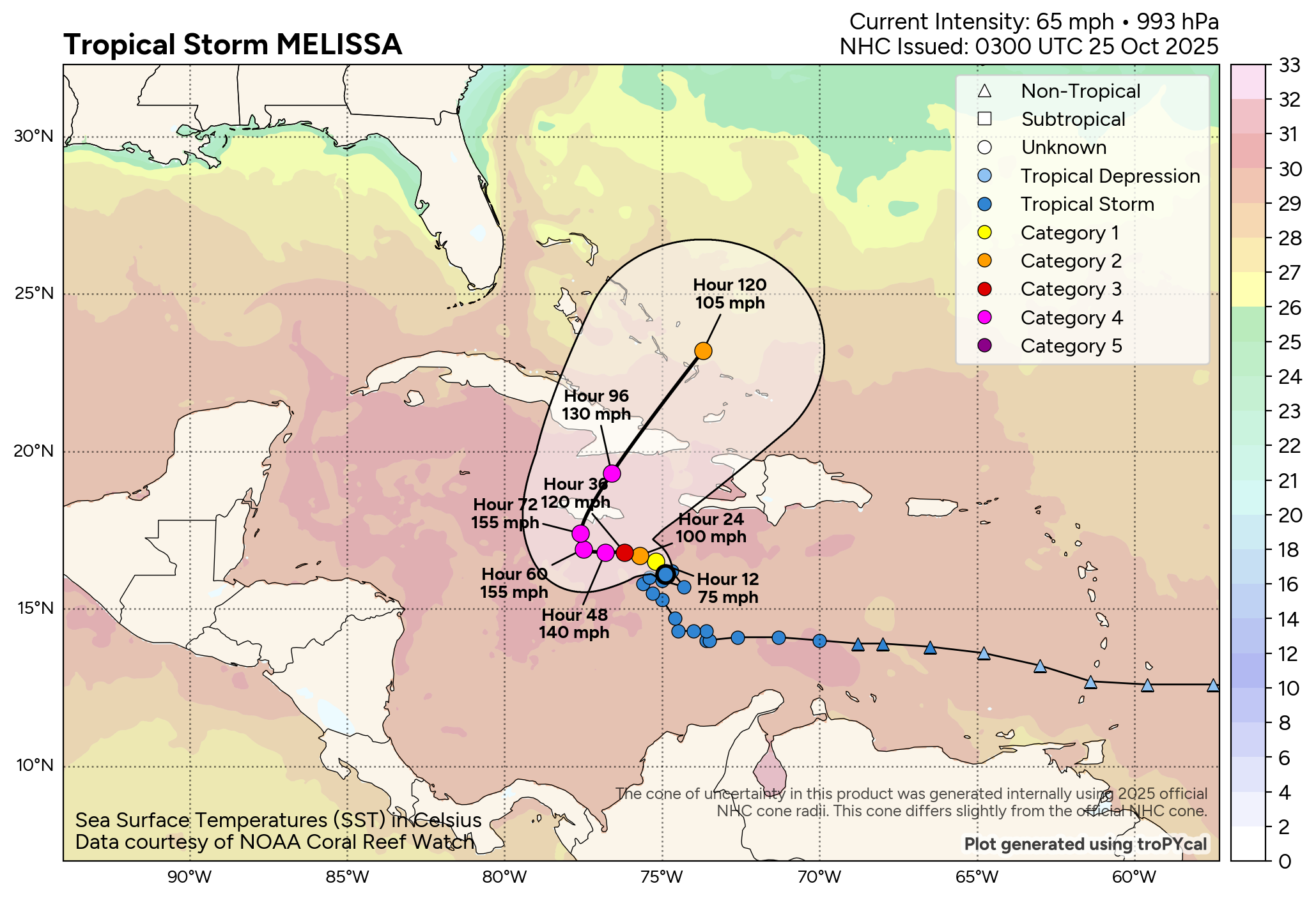
The track forecast remains challenging in both the short and long term. In the short term, Melissa is currently in weak steering currents and reconnaissance data over the last few hours actually suggests the center has been drifting (or reforming) northeast. It is expected that enough high pressure aloft will develop north of the storm to cause a west or northwest drift in the general direction of Jamaica this weekend. Eventually as a new strong upper level trough of low pressure evolves over the eastern United States, Melissa should start to be pulled north or northeast out of the Caribbean, and at that time the threat will increase to eastern Cuba and the Bahamas.
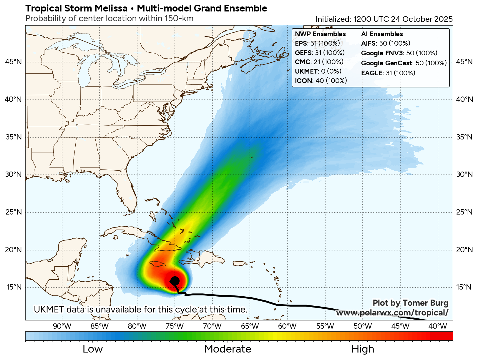
In the longer term beyond day 5 of the forecast, the bulk of the model guidance suggests a northeast track in the general direction of Bermuda. However, as we talked about yesterday, the intensity and location of that upper level trough in the eastern US will play a pivotal role in the final track of Melissa — and as of now the models are still quite all over the place as far as that system. Additionally, how far west Melissa gets in the Caribbean before making the north to northeast turn will be important. Right now, the potential for any impact in the Northeast is very low, but until we get better clarity on the eastern US upper level low and the shorter term track of Melissa, it is not zero. The probability slightly higher for potential impacts in the Canadian Maritimes — although the system would very likely be transitioned to a post-tropical cyclone by the time it reached that far north.
![[Key Messages]](https://substackcdn.com/image/fetch/$s_!Ug_0!,f_auto,q_auto:good,fl_progressive:steep/https%3A%2F%2Fsubstack-post-media.s3.amazonaws.com%2Fpublic%2Fimages%2F02f1f9b3-bdf7-4bfd-b281-b6c8d93bf81f_897x736.png "[Key Messages]")
The NHC key messages product above does a great job of summarizing the potentially catastrophic impacts expected as Melissa intensifies and moves very slow across the central Caribbean region into early next week. Rainfall totals of 20-30” are now explicitly forecast for the eastern half of Jamaica and parts of southwest Haiti which would cause devastating flash floods and mudslides. Again, that rainfall graphic above is just through midday Tuesday — additional very heavy rainfall is likely through at least the middle of next week.
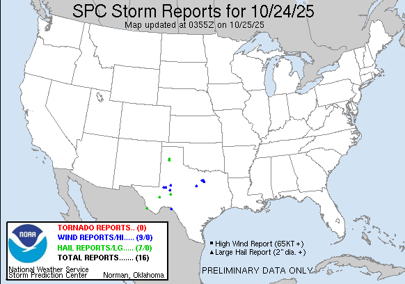
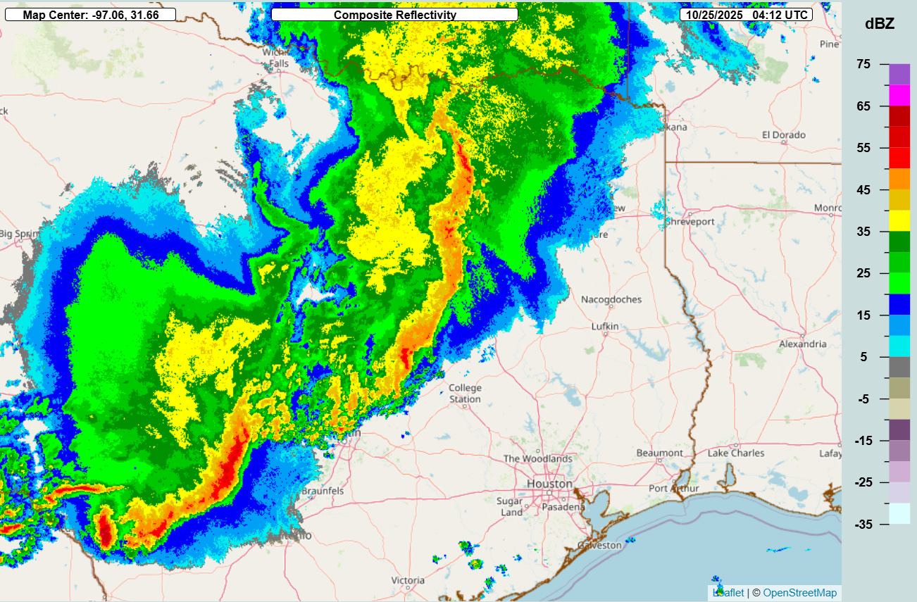
I will finish off with a quick highlight that a band of strong to severe thunderstorms continues to move across eastern and central Texas late this evening, after producing a number of reports of wind damage and large hail across the state. PowerOutage.us reports that more than 60,000 customers are without power in Texas as of 11 pm CT.
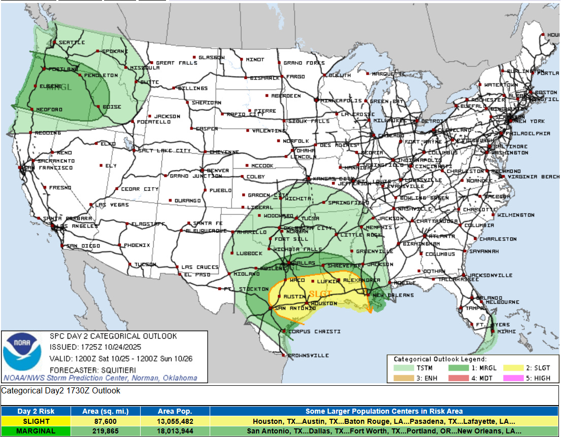
A threat of severe weather is expected to persist overnight and into Saturday as the thunderstorm activity moves east.

Flash flooding will also be a concern with a slight (level 2 of 4) risk of flash flooding from parts of the Mid-South to the Gulf Coast.

Leave a comment