Fung-Wong briefly reaches super typhoon status before landfall in northern Philippines.
Nov 09, 2025

Late Friday, a powerful tornado moved through parts of Parana state in southern Brazil. The most damaging impacts occurred in Rio Bonito do Iguacu, a city of about 13,000 people. According to media reports, about 90% of the building in the municipality suffered some level of damage. Six people were killed and 750 were injured, of which nine remain in serious condition.
It may sound unusual to see a significant tornado in South America, but while the United States is home to the greatest frequency of tornadoes worldwide, there are other favorable regions around the globe for severe thunderstorms and tornadoes. This part of Brazil is in a favored area for tornadic activity that exists across southeast South America, and which is one of the more tornado prone areas outside of the United States.
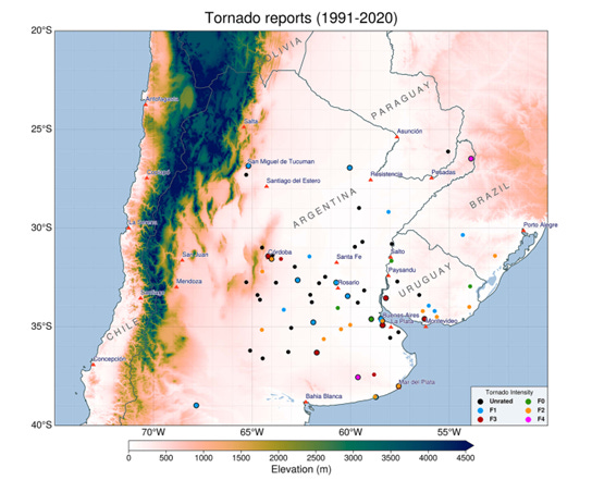
The graphic above shows tornado reports over the last 30 years is from a 2023 paper by a team of scientists at Colorado State University examining the environments in which severe thunderstorms and tornadoes form in this region of the world. This Pampas region of South America has a somewhat similar geography to the Plains region of the United States as far as thunderstorm formation: moisture comes into the region from the north and northeast off the Atlantic, while cold, dry air aloft comes in from the west off the Andes above this moisture to yield an unstable atmosphere supportive of intense thunderstorm activity.
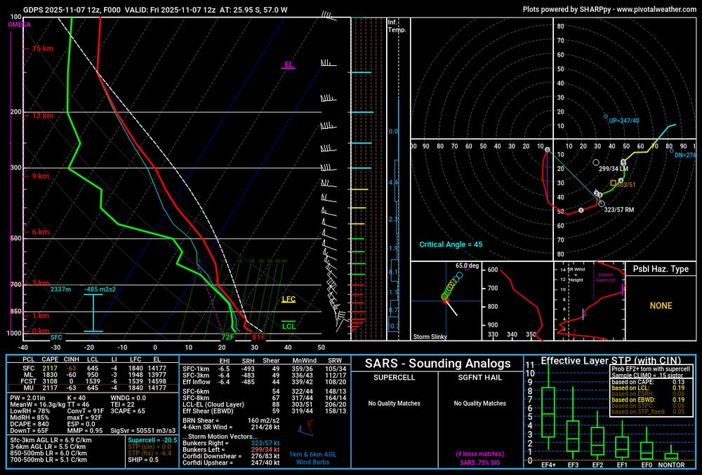
When strong weather systems move through this environment, it can yield favorable conditions for tornadoes, and this happened Friday. This sounding from the region on Friday posted on BlueSky by my colleague Andrew Berrington shows a very favorable environment for tornadoes, with strong low level wind shear and a very unstable atmosphere.
For those familiar with looking at these soundings for severe weather events in the US, this sounding looks different as the low level winds are northerly instead of southerly and parameters such as storm relative helicity are negative instead of positive, all because low pressure is clockwise in the Southern Hemisphere versus counter-clockwise in our part of the world north of the equator. The Southern Hemisphere is in its spring season, and just as in the US, this is a favorable time of year for severe thunderstorms in this part of South America, so there could be more activity to come.
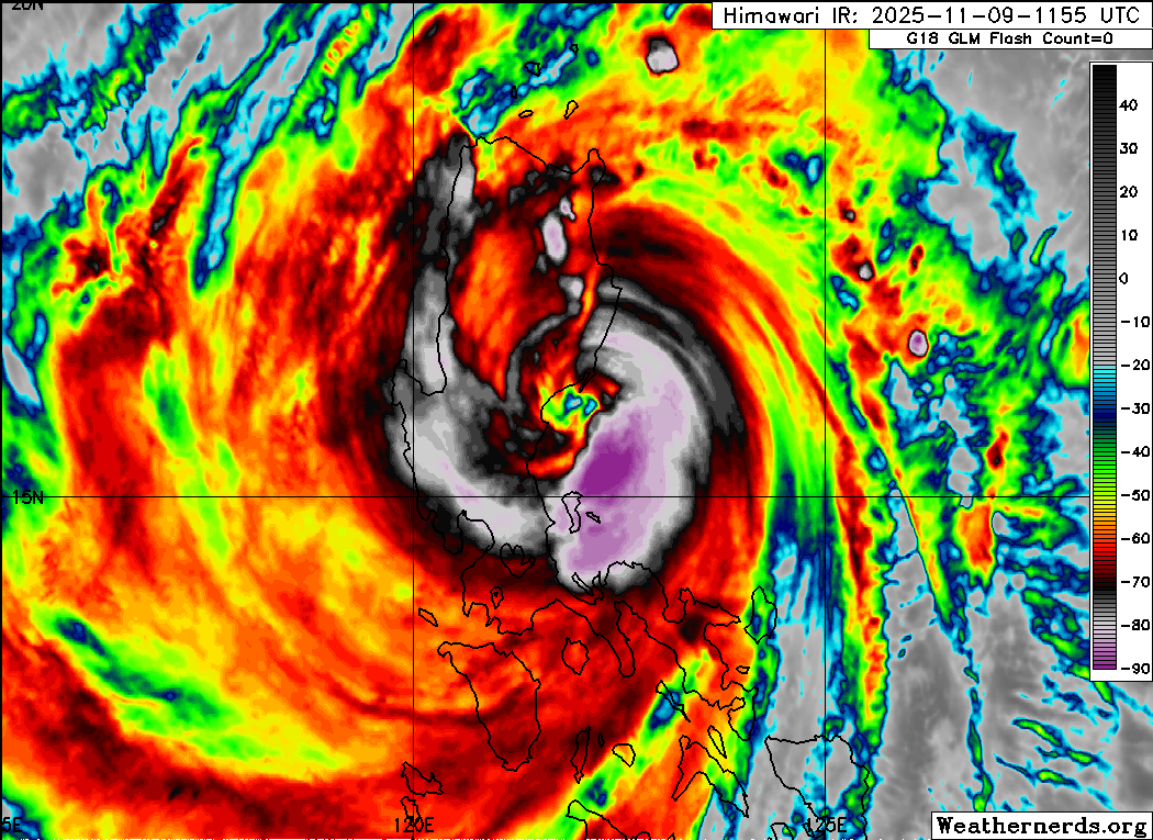
Fung-Wong did in fact peak out as a category 4 super typhoon overnight (US time), but weakened a bit before making landfall northeast of Manila. Still, it was a powerful typhoon as it moved over land, and significant storm surge, wind damage and flooding likely occurred. Impacts will continue across the northern Philippines as Fung-Wong moves west-northwest over the next 24 hours, with torrential rain and flash flooding being a serious risk.
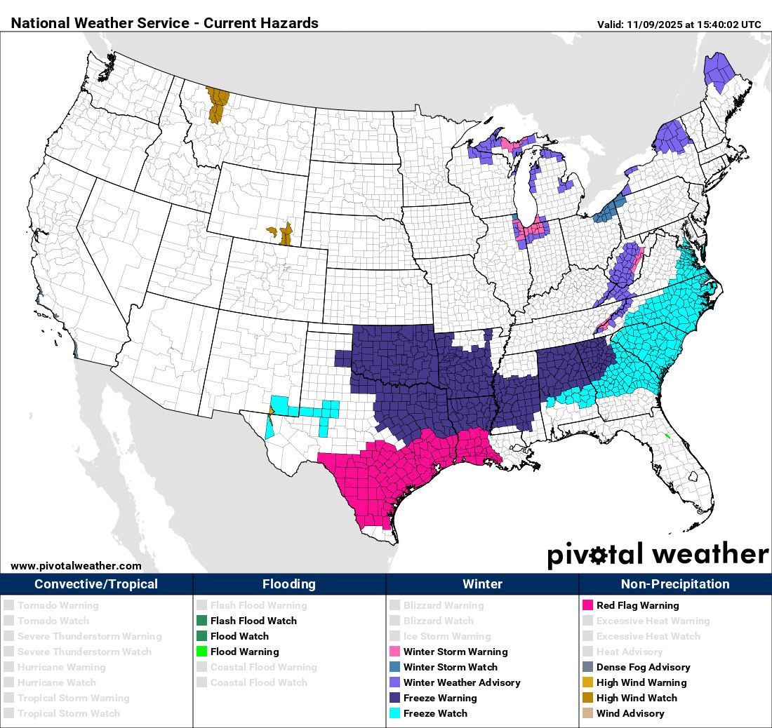
Unseasonably cold air will continue to push south into the central and eastern United States today, and freeze warnings and watches are in effect for much of the southern United States from Texas east. Additionally, strong, dry northerly winds will create dangerous wildfire conditions across much of south Texas and western Gulf Coast region today, and red flag warnings are in effect for these areas.
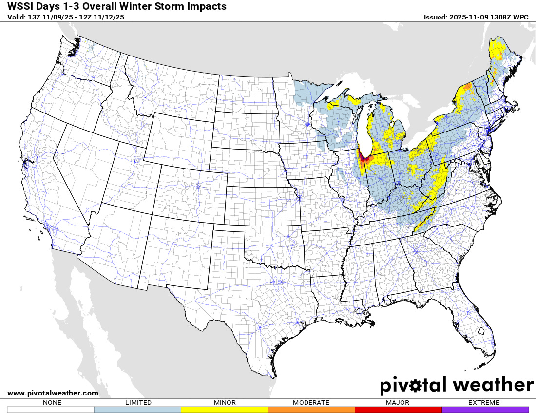
Those strong, cold northerly winds will also bring bands of significant lake effect snow to favored regions downstream of the lakes the next couple of days. As the Weather Prediction Center Winter Storm Severity Index (WSSI) shows, the most significant impacts from these lake effect snow bands look to be in the lee of Lake Michigan, where north-northwest to north-northeast winds will cause lake effect bands to impacts the Chicago area as well areas such as South Bend and into southwest Lower Michigan. Winter Storm Warnings (see map above) are in effect as lake effect snow bands will cause hazardous driving conditions with poor visibility and rapid snow accumulation, with the potential for up to a foot of snow where lake effect bands are most persistent. Winter storm warnings are also in effect for parts of the central Appalachians where northerly winds from the Great Lakes will carry moisture up the mountains, resulting in heavy snow at higher elevations.
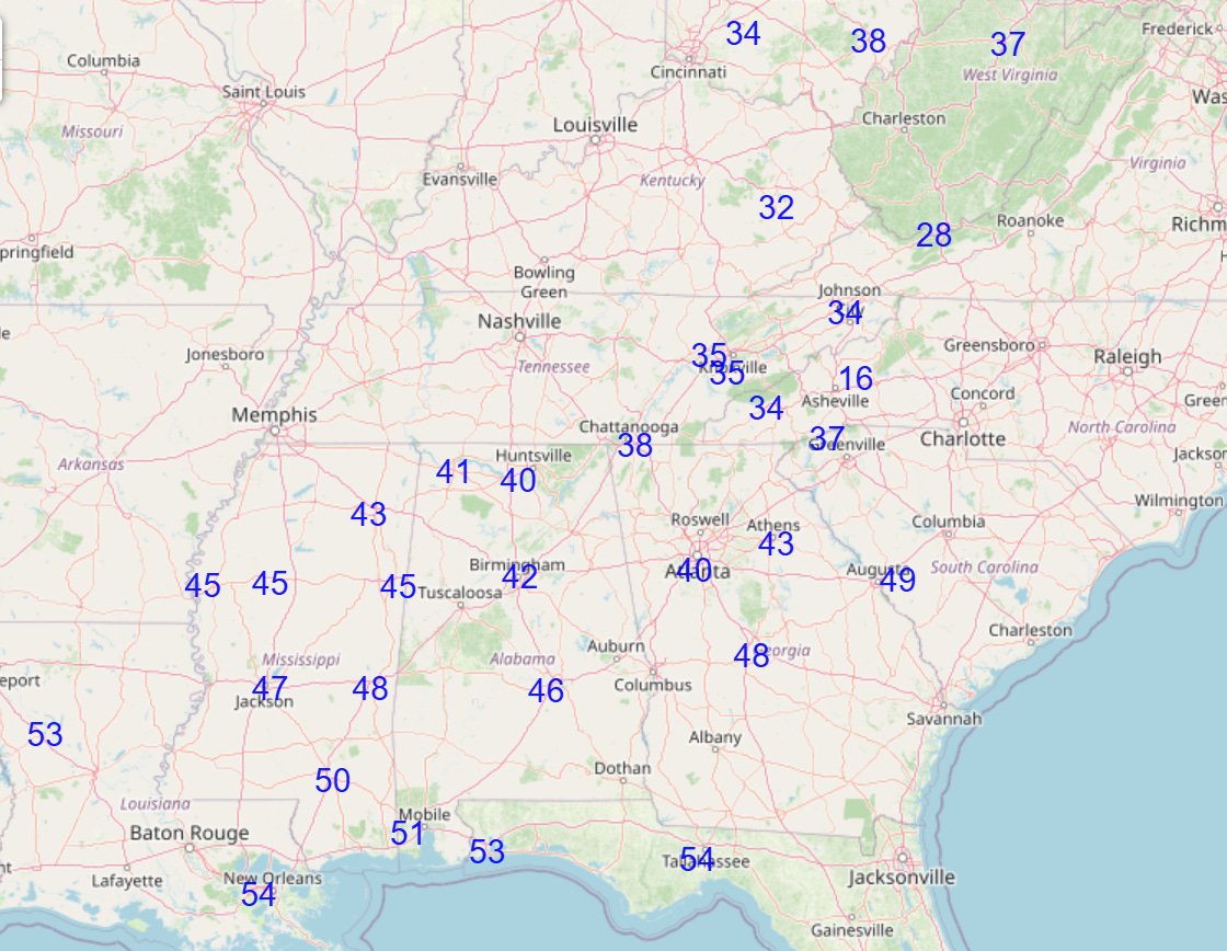
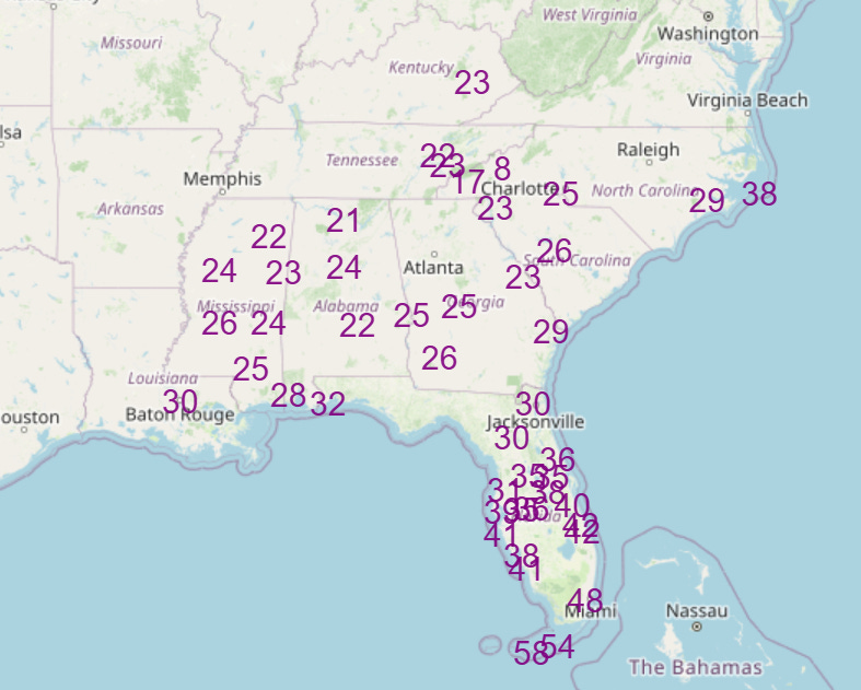
Numerous record cold temperatures, both cold maximum temperatures on Monday (top graphic) and record lows on Tuesday morning, are anticipated over the southeast quarter of the country. Again, while this will be an unusual, record breaking cold snap, it will be short lived, with much warmer conditions building in from the west in the middle to latter part of the week.
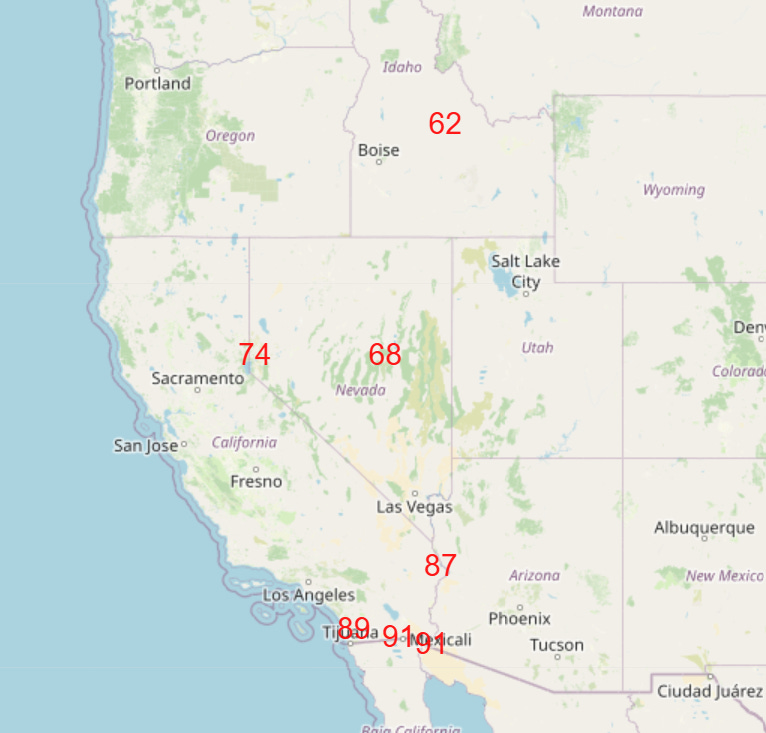
In fact, while the East is dealing with this deep freeze, the West will see unusually warm temperatures the next couple of days, with several record high temperatures possible on Monday as shown above.
Note: The US weather community relies on the work of NOAA scientists who are exempt from the ongoing federal furlough due to the life-saving nature of their work. These federal employees are in their 40th day of working without pay and without knowing when they will eventually receive pay. You can read more about this situation in this post.

Leave a comment