More record warmth in the southern US today
Nov 19, 2025

I was excited and honored to start my day today by being the featured speaker in the morning plenary session at the annual conference of International Association of Emergency Managers. Myself and IAEM President Carrie Speranza had a conversation about Hurricane Katrina as we acknowledge its 20th anniversary, and why that event was a pivotal moment for strengthening the collaboration between the meteorology and emergency management communities. That relationship was already becoming stronger before 2005, but I think that Katrina truly showed the weather community the crucial role that EM plays in performing the societal work that helps improve outcomes in weather disasters. For myself, my work with the incredible emergency management professionals in Mississippi was the impetus for my eventual work to obtain a master’s degree in EM at Millersville University.
I talked with Carrie about my experience in the growth of that relationship, and how I feel that the emergency management community has an important mission to hold the meteorological community accountable for the quality of its services and continually improving those services. Carrie asked me at the end for one thing that the weather and EM communities could work on in the next 5 years that is most needed, and I told her improving services, risk management and public education for flash flooding. I am increasingly convinced that this hazard is where the most work is needed to reduce deaths and human impact, and is also where there is a lot of ongoing research that can make quick gains. In related note, I am planning to an in-depth post about the July 4-5 Texas Flash Flood talking about some of the issues I have encountered in the aftermath of that event.
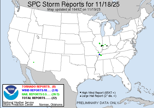
Turning to weather, yesterday afternoon and evening ended up being a fairly active severe weather period for the lower Ohio Valley, with more than 20 severe weather reports. Hail was the primary severe weather hazard, with a few reports of 2-2.5” diameter hail.

Today, the system responsible for that severe weather will be moving off the East Coast. Meanwhile, the system that has been bringing heavy precipitation and some flooding to the Southwest will move far enough east to result in increasing shower and thunderstorm activity in the south central US. A few of these storms could be severe, and localized flash flooding is possible, particularly over southwest Texas where a slight (level 2 of 4) risk of flash flooding exists.
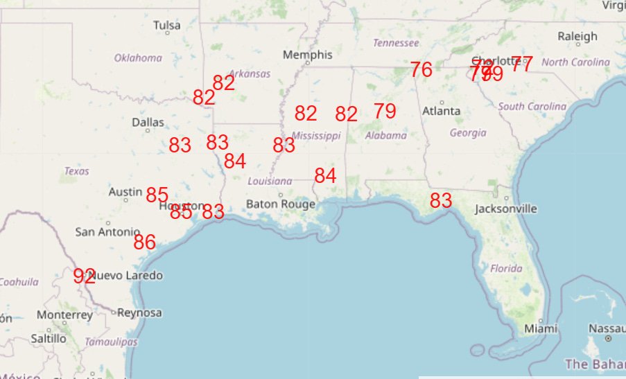
A number of record warm temperatures, both maximums and minimums, were set across the south central states in the last 24 hours, and this record warmth will expand to encompass much of the Southeast today (forecast record highs today shown above).

Leave a comment