Next storm system to bring a wide swath of heavy snow to the Midwest Friday into Saturday
Nov 27, 2025
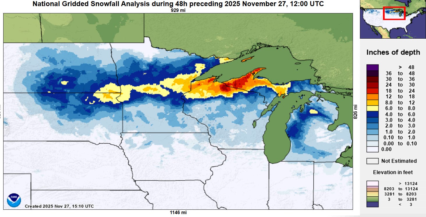
Happy Thanksgiving! The upper Midwest this morning awakened to a blanket of white, as the storm system we have been talking about the last couple of days dropped a swath of heavy snow across the region. As expected, the heaviest snow fell near Lake Superior where moisture off of the lake enhanced snowfall. The highest snowfall report so far per the NOAA/NWS Weather Prediction Center is 33” at Gile, WI. This storm system also produced strong winds, with wind gusts of up to 78 mph reported in South Dakota.
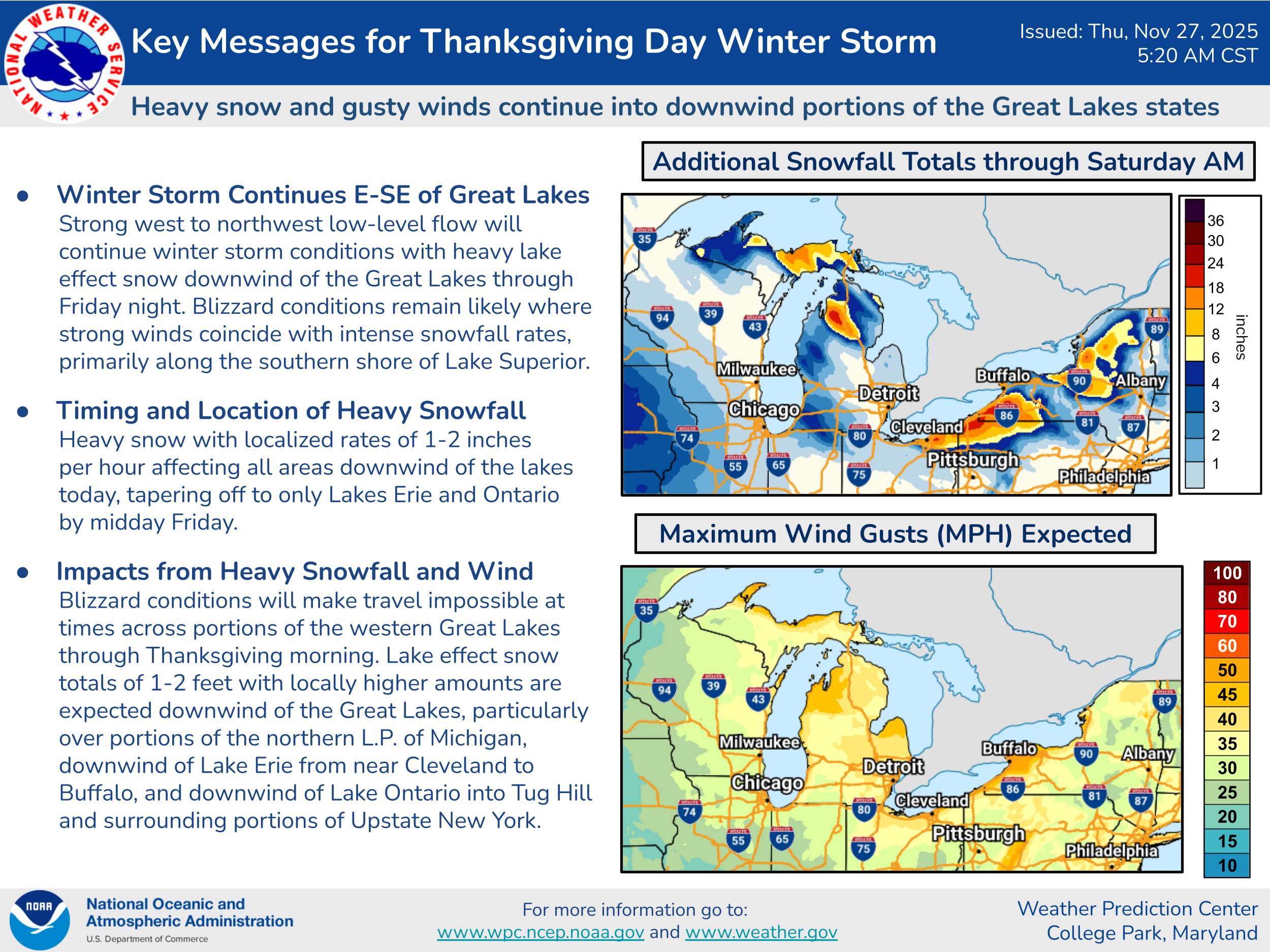
While this storm system has pulled off to the east, strong and cold northwest winds blowing across the Great Lakes will cause heavy lake effect snow downwind of the lakes. Additional localized snowfall totals of 1 to 2 feet will be possible in the snowbelt regions in the lee of the lakes, and with strong winds as well, blizzard-like conditions will occur in the heaviest snow bands. Travel will obviously be difficult in these regions today, and into Friday in lake effect snowbelt regions of the eastern Great Lakes.

Scattered snow showers and cold, blustery conditions are expected much of the Northeast today, while the Northwest will continue to be plagued by rain and mountain snows as a series of storm systems moves through the region. Most of the country, though, will see dry weather today.
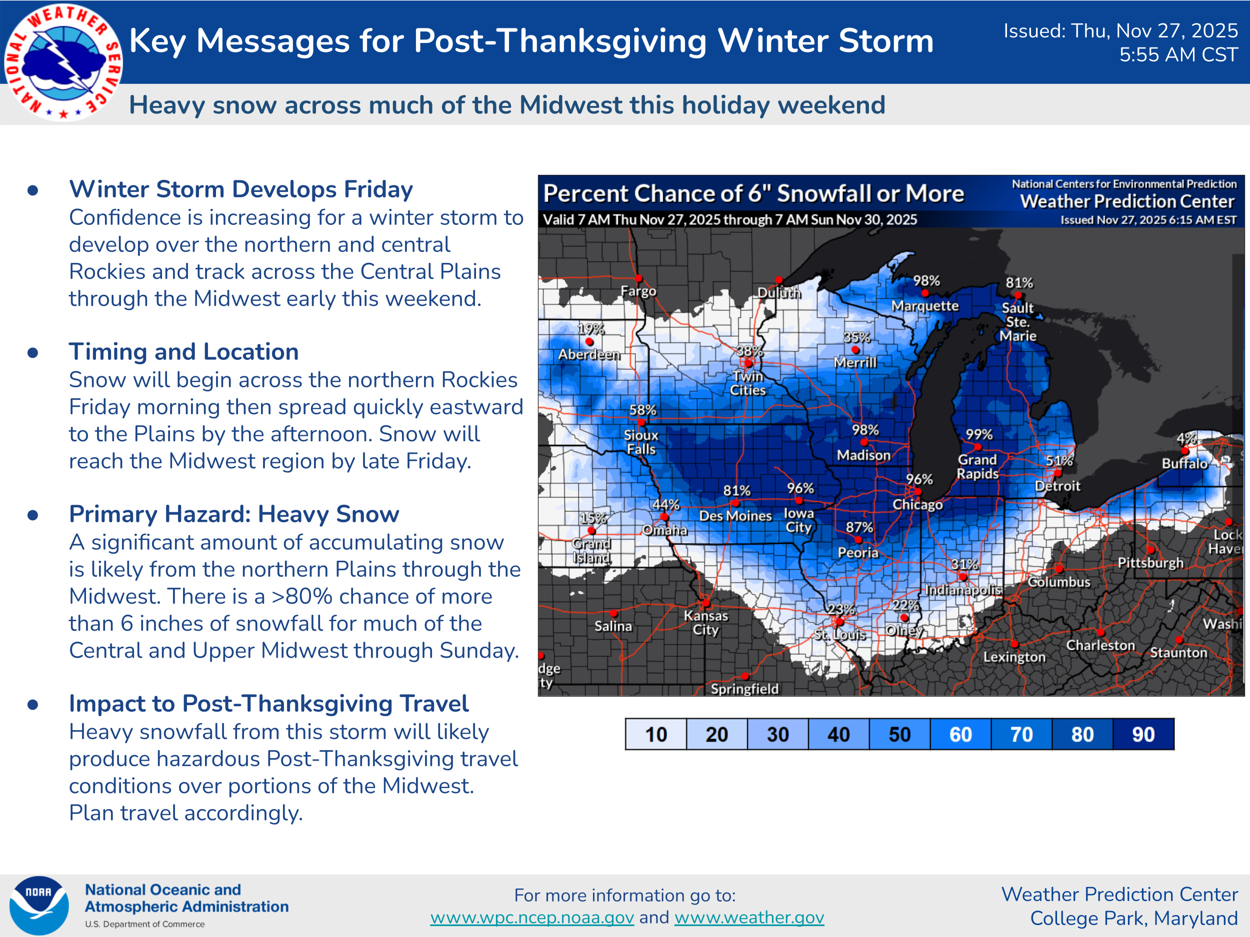
Attention will then turn to the next storm system which is expected to bring a wide swath of heavy snow from the northern Rockies east across the Midwest and western Great Lakes Friday into Saturday. The forecast track of this weather system has shifted somewhat south over the last 48 hours, with much of Iowa across southern Wisconsin and northern Illinois into northern Indiana and the Lower Peninsula of Michigan now in the forecast band of heaviest snow.
The forecast map above shows the probability of greater than 6” of snow from this system, and along with the very high probabilities in the area I described above, you can also see moderate probabilities of 25 to 50% extending southward to about the Interstate 70 corridor from St. Louis to Indianapolis, with the timing of potential heavy snow here Friday night and into Saturday. As the track of this system has shifted south, the potential for heavy snow has shifted south to encompass these areas as well. However, the forecast here is much more uncertain, as warmer air in lower levels of the atmosphere will be trying to surge north, and the precipitation type will be dependent upon how intense the precipitation rates are, with heavier precipitation more favorable for snow and lighter precipitation more favorable for rain. As the event gets closer and the high resolution models hopefully help provide more detailed information on how the precipitation will evolve, we should get a better handle on the forecast, so people here should be keeping abreast of the latest forecast.

On the warm side of this system, showers and thunderstorms are expected across the south central US. This system does not look like a particularly significant threat for severe weather or flash flooding, but a few incidences of severe weather and localized flooding are possible.
On this Thanksgiving Day, I sincerely thank all of you who have supported Balanced Weather as I have worked to spin it up since my retirement in March. If you are not yet a subscriber and would like to get these daily updates — or even become a paid supporter with access to live videos and weather chats and the ability to comment or ask questions on posts — click below. I hope everyone has a wonderful Thanksgiving!!

Leave a comment