In weather, record cold and some snow over the central and eastern US
Dec 04, 2025
Starting off this morning with a developing story that’s slightly out of the weather world but definitely in the earth sciences world and has enough connection I want to talk about it. The United States Geological Survey (USGS) is the federal agency responsible for earthquake monitoring and warning.

Its ShakeAlert system is a relatively new earthquake early warning system (EEW) serving California, Oregon and Washington, designed to detect seismic waves early enough to give people seconds of warning by sending a warning message to cell phones before strong shaking arrives during a significant earthquake.
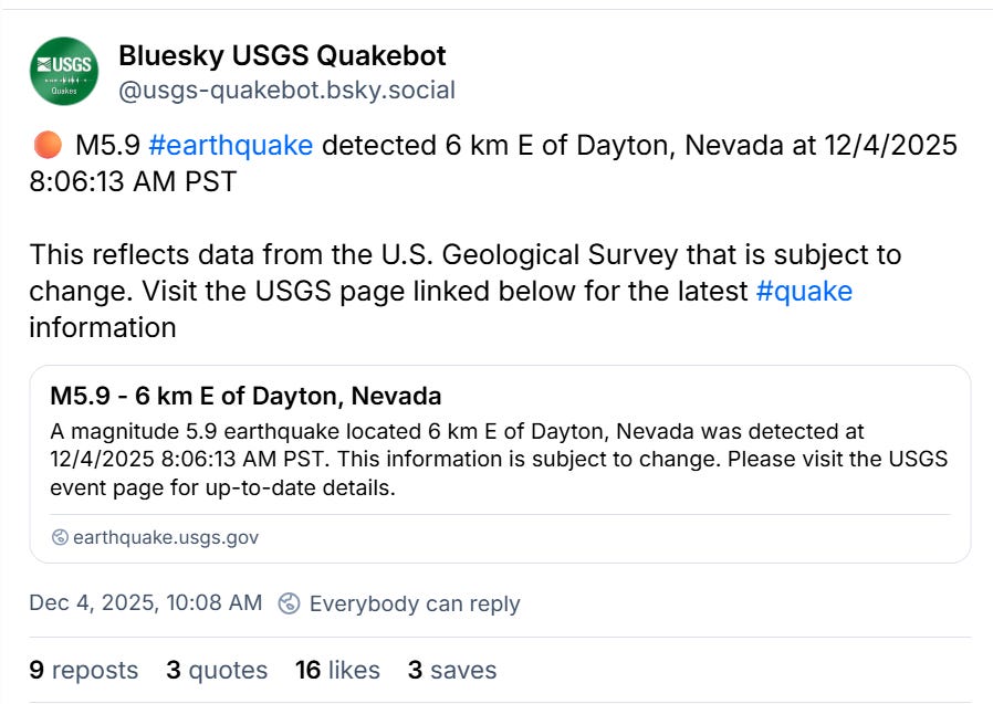
The ShakeAlert system was activated this morning in parts of the region, and shortly thereafter the USGS posted a notification that a magnitude 5.9 earthquake had occurred at 10:06 am CT 6 miles east of Dayton, NV, which is a town just southeast of Reno. An earthquake of this magnitude can cause some damage but given the location social media started to debate whether or not ShakeAlert should have activated and if this was a “false alarm” for ShakeAlert.
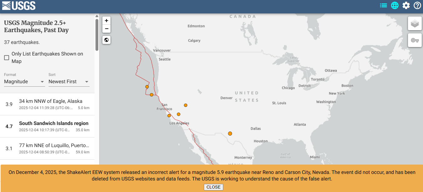
Then it got even more confusing. Since this initial alert, the USGS has stated that the the warnings and earthquake notification were for “an event that did not happen.” The original notice of the M5.9 earthquake has been deleted from its website. Needless to say, this has led to rampant speculation on social media about how this could have happened. This notice from the USGS webpage states that they “are working to understand the cause of the false alert” so hopefully we will know more soon.
This episode will certainly raise questions about whether or not federal science staffing and budget cuts may have impacted the USGS earthquake warning and detection systems, similar to what happened with questions about the National Weather Service after the July 4th Texas flash floods. Until we know more about the details of why this false earthquake detection occurred, it is obviously impossible to say.
From a general sense, though, I think it is important to note that the Trump Administration proposed a 38% cut to the USGS budget for Fiscal Year 2026, and per the American Geophysical Union this would include reductions in support for geophysical programs such as earthquake hazard mitigation and volcano observatories. As I have discussed in earlier posts, USGS plays a key role in flood forecasting for the United States, as its network of streamflow gages is the backbone for hydrologic data in this country. This network has been shrinking in recent years due to flat funding and increased costs, and further funding reductions will put it in even greater danger.
The bottom line is that USGS is another federal science agency that Americans rely on every day but do not realize it until an event like today’s false earthquake detection brings it into the foreground. While we definitely need to understand more about what happened today before jumping to conclusions, this event reinforces the importance of federal science in the safety and livelihoods of the citizens of our country, and why it is so important that these agencies be operated in a smart, efficient way that maximizes their efficacy. I do not think that anyone that worked in the federal science apparatus does not believe that serious changes and improvements are needed, but these changes need to be done thoughtfully and deliberately. In my opinion, the evidence to date clearly suggests the administration is not approaching things in that manner — hopefully Congressional appropriations and deliberations will result in more thoughtful approaches.

Taking a quick look at the weather today, a new storm system is developing along the central Gulf Coast. Widespread rain and thunderstorms are expected across the South from this system. Some light wintry precipitation is possible along the northern fringe of the precipitation shield, but impacts are expected to be fairly minor.
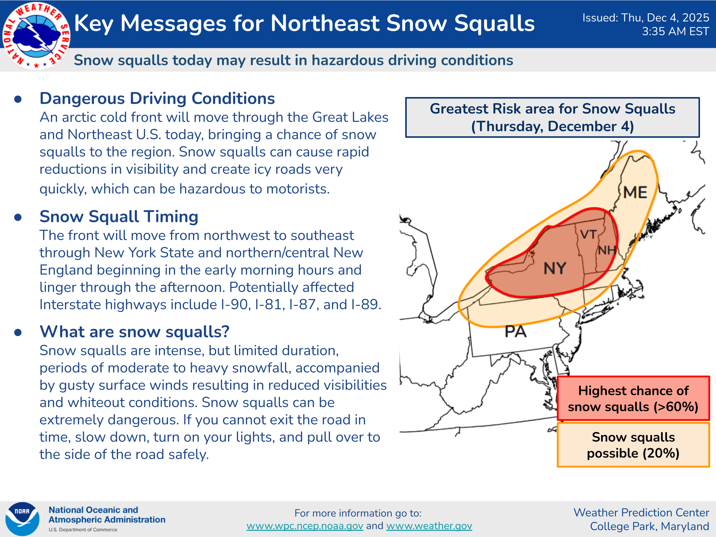
Snow squalls are possible again today in the Northeast, which could impact travel with periods of poor visibility and slick roads.

Later tonight into Friday, a bit more in the way of wintry precipitation should occur along the northern part of the precipitation shield associated with this low pressure system as it moves into the Florida Panhandle. Winter weather advisories are in effect for much of Virginia and adjacent portions of North Carolina and northeast Tennessee. Much of this wintry precipitation in Virginia looks to fall in the form of snow, with localized amounts of up to 4” possible; some sleet and freezing rain could occur, especially farther south in North Carolina and Tennessee. Meanwhile, a new storm system in the West will mean areas of heavy snow over the next 48 hours as shown in the graphics above.
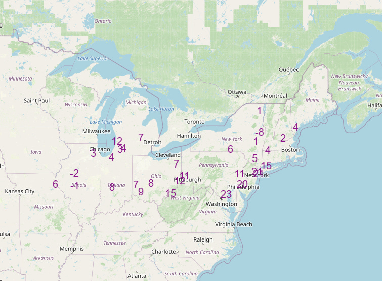
This wintry weather is being supported by an unusually cold early December airmass across the central and eastern United States. The combination of this cold airmass and relatively fresh snow cover brought some record lows to the Midwest this morning, and additional record lows (above) are anticipated Friday morning from the Midwest into the Mid-Atlantic and Northeast.
Balanced Weather is made possible by the generous support of paid subscribers, who as thanks get access to live Balanced Weather chats and videos as well as the ability to post comments and ask questions on Substack posts. Click here to become a paid supporter of Balanced Weather at a holiday special rate of 15% off for the next year.

Leave a comment