But overall wet pattern with additional heavy rainfall events looks locked into the region for the foreseeable future. Also examining prolonged unseasonable warmth for *most* of the West.
Dec 11, 2025
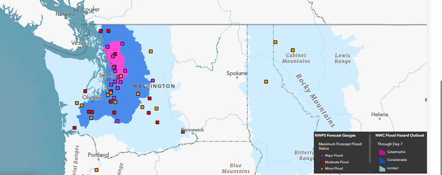
Rain continues across the Pacific Northwest this morning but the intensity continues to gradually taper off. While some rivers in the region — especially in and near the Olympic Peninsula — have crested, a number of rivers in the Cascades continue to rise and will reach their peak stages over the next 24 hours.
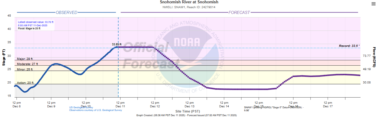
The Snohomish River at Snohomish has exceeded its all-time record (period of record goes back to at least the early 1940s). The forecast anticipates that the river is near its prolonged crest.
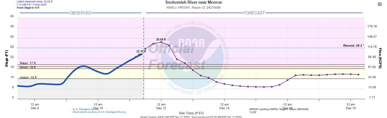
Upstream of Snohomish, the river is still rising at Monroe, and the recently updated forecast now anticipates the river breaking the record here by nearly 3 feet (records here go back to at least the mid 1960s). Given that the river is still rising upstream of Snohomish and based on the pattern of the forecast, my assumption is the river at Snohomish looks to have at least some of its flow controlled by upstream dams which is why it has such a prolonged, steady crest.
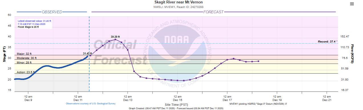
The Skagit River is another river that is continuing to rise, and as I talked about in yesterday’s post the NWS was forecasting it to shatter records by 4-5 feet. Luckily, the river does not appear to be rising as much as earlier forecasts anticipated, and the forecast has been lowered at Mt. Vernon but still shows a record crest by nearly 2 feet.
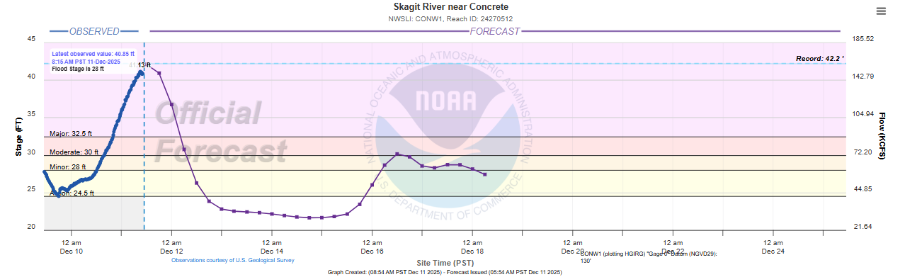
Upstream of Mt. Vernon at Concrete, the river actually looks to be cresting just below its record. Even though the Skagit is not reaching the extreme levels forecast yesterday, it is important to recognize that even at these levels extensive, serious flooding is occurring along portions of the river.

Major impacts are ongoing across the entire region. Nearly 100,000 people are under evacuation orders per the state governor’s office, and media reports that numerous water rescues are ongoing. A number of major highways are closed due to flooding and landslides, including parts of Interstate 90. Amtrak service between Seattle and Vancouver has been suspended due to flooding along the Skagit River.
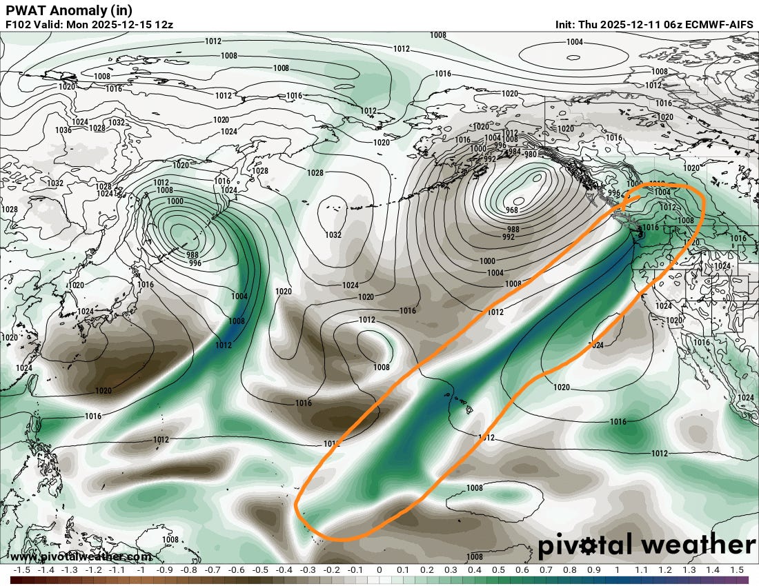
It still appears as though a break from the heavy rainfall will occur over the region Friday through Saturday. By early next week, the pattern of an “atmospheric river” of moisture originating deep in the tropical Pacific well southwest of Hawaii will take aim on the Pacific Northwest again (shown above). As strong atmospheric disturbances move through the region, more waves of heavy precipitation are anticipated. This wet pattern will likely persist much of the week.
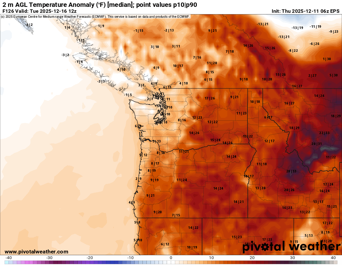
Through at least the first part of next week, temperatures are expected to remain above normal across the region (European ensemble surface temperature anomalies for Tuesday shown above), which should also keep snow levels higher than normal, which as discussed has been a significant factor in the severity of the flooding. The bottom line is while the river levels should start to fall across this region after the next 24 to 36 hours, more widespread heavy precipitation could cause additional flooding threats across the Northwest next week.
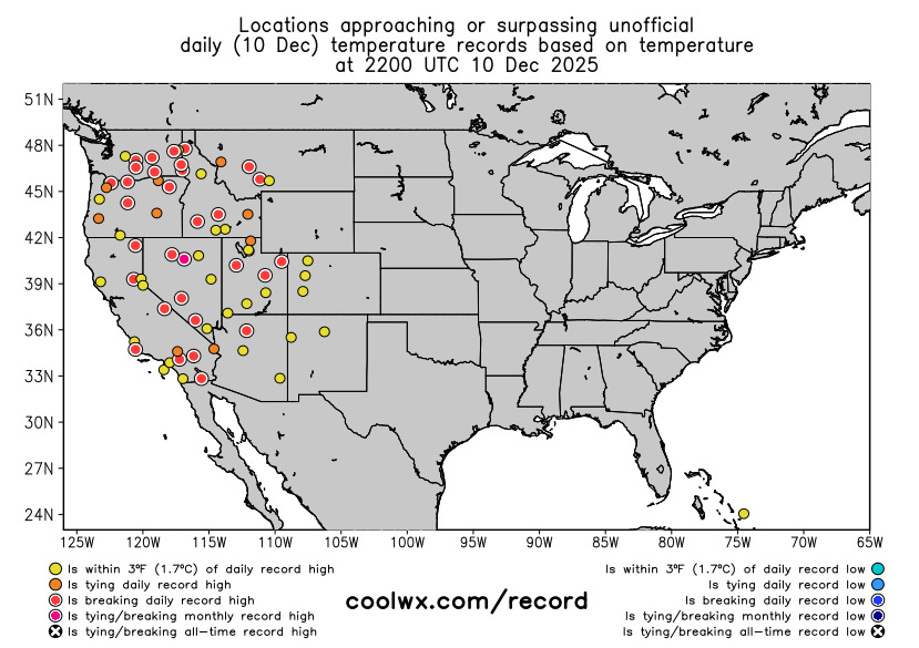
Temperatures are the other big weather story across the country, with record warmth dominating the western United States under the unusually strong middle and upper level area of high pressure across the region. Numerous record high temperatures were set across the region on Wednesday, with many more records expected the next several days.
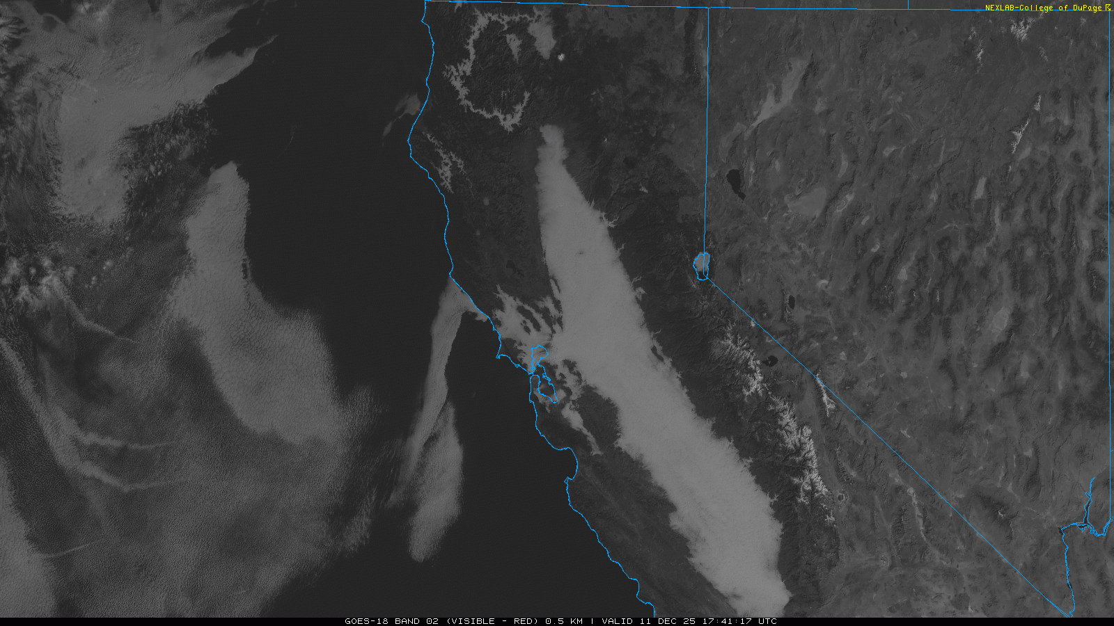
One important exception to this warmth is the San Joaquin Valley of California. Under stagnant weather patterns like the West is currently locked in, low clouds and fog can become trapped in this valley and other nearby valleys toward San Francisco Bay, resulting in cool, dreary weather.
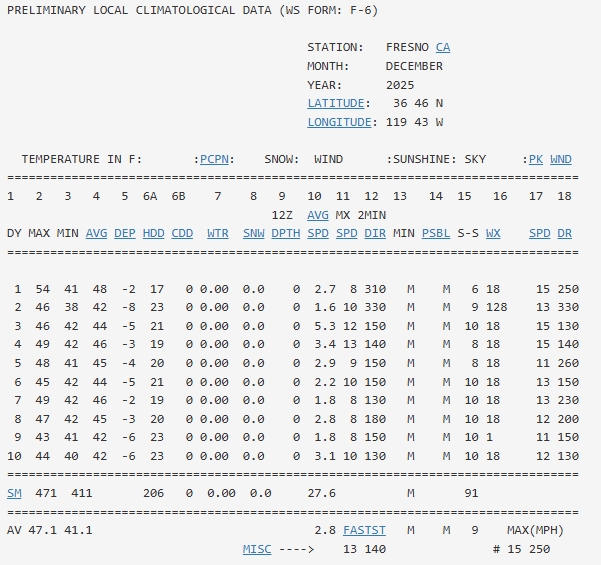
This has been the situation in this area for many days, with Fresno not climbing above 50F since December 1st, and having completely overcast sky conditions nearly every day back to the beginning of the month (column 15 in the table above, 10 means 10 of 10 for sky cover). This stagnant weather setup also yields poor air quality, and air quality advisories are in effect for this region as well.

Meanwhile, downstream of the upper level high pressure in the West, colder air and occasional Alberta Clippers are yielding occasional light to moderate snowfall and mixed wintry precipitation, with some heavy lake effect snow in the eastern Great Lakes.
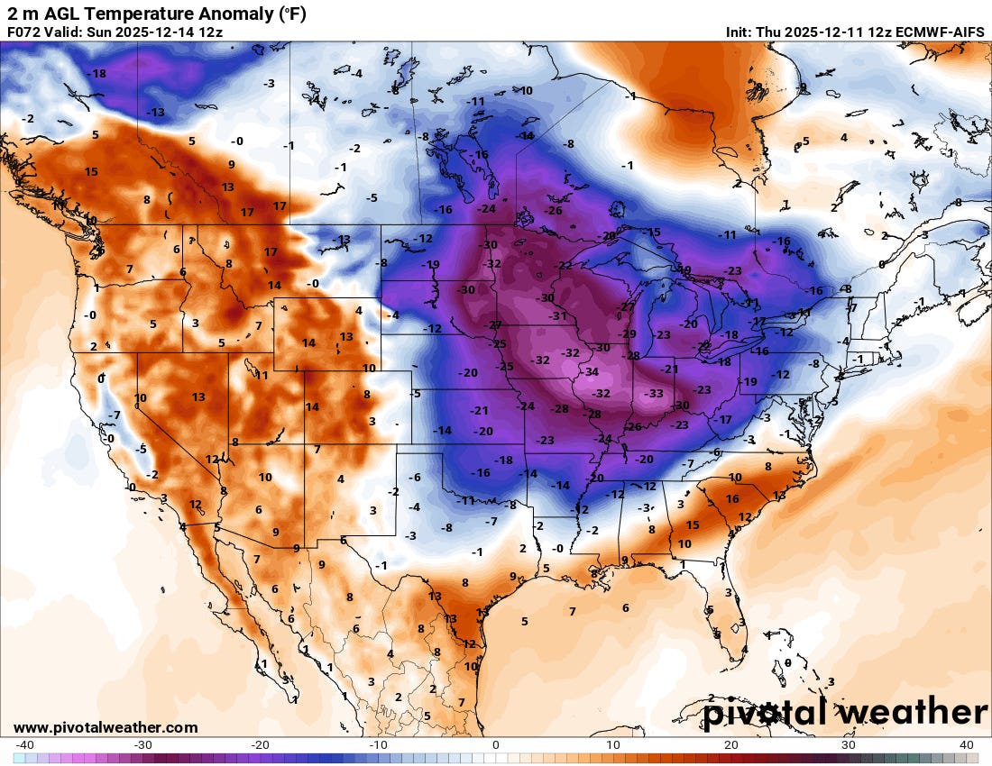
As the upper level high pressure in the West strengthens even more over the next 48 hours, this will allow arctic air over the Northwest Territories of Canada to start spilling southeast, eventually overspreading much of the central and eastern United States this weekend. Temperatures will be as much as 35F below normal in the core of the colder air over the Midwest and Ohio Valley, where some record cold temperatures are possible this weekend, particularly record low maximums on Sunday. There are signs though that the warmth in the western United States will start to build east across the country next week, bringing at least a reprieve from the cold, snowy start to the winter in the eastern half of the country.

Leave a comment