Storms systems continue to parade into the West with heavy rainfall and flooding
Dec 18, 2025
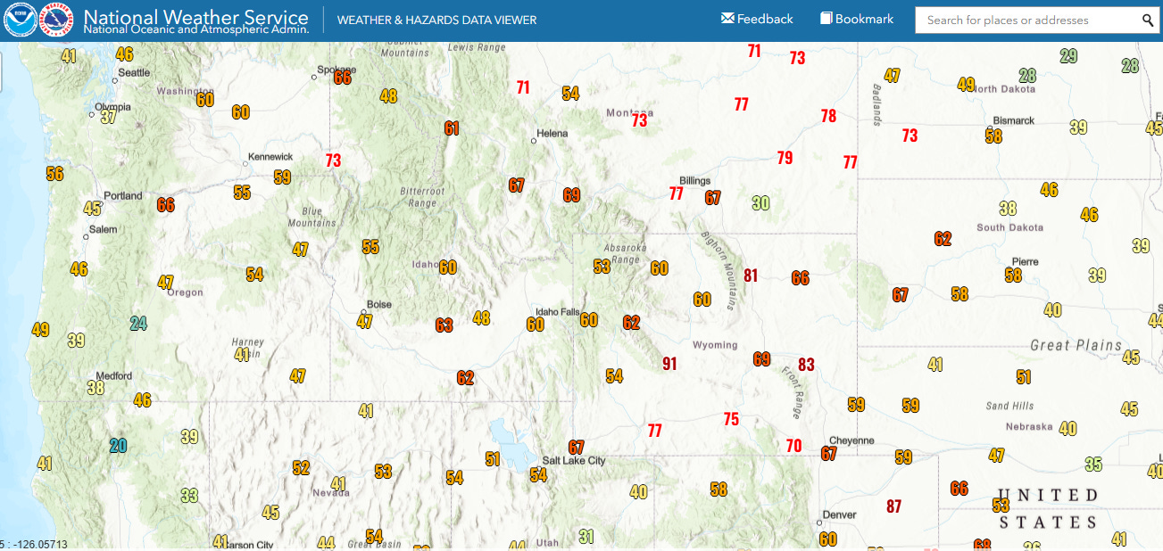
Wind and warmth were the big weather stories of the last 24 hours, and we are starting this morning with the most impactful, namely the wind. Much of the northwestern quarter of the country was blasted with high winds on Wednesday as an intense low pressure system moved east along the US/Canada border. Maximum wind gusts yesterday are shown on the map above; Glasgow, MT reported its all-time record strongest December wind gust with 78 mph, breaking the old record off 66 mph set in 2000. A number of locations reported maximum gusts greater than 90 mph, and impacts such as power outages, downed trees, vehicles toppled were widespread. Per PowerOutage.us, power outages peaked at nearly 750,000 customers, and this morning about 325,000 customers are still without power.

Colorado is the state with the most power outages currently, with more than 100K customers down. Downslope winds hammered the Foothills region in the western part of the Denver metro area late Wednesday afternoon, with the wind sensor at the NCAR Mesa Lab (the lab I wrote about yesterday) in Boulder reporting a maximum wind gust (above) of nearly 50 m/s or 109 mph. More about the impacts — including some wildfires with evacuations in eastern Colorado — can be found here.
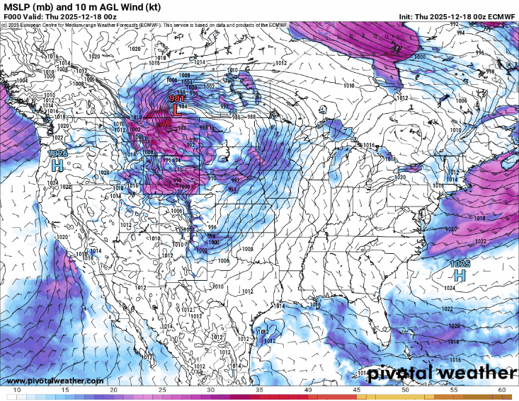
This animation shows the forecast for the mean sea level (surface) pressure (contours) and surface winds (image) from the European model. At the start of the loop, the strong low pressure center responsible for all of this wind is over the upper Midwest, and you can see it shift east across the Great Lakes and southern Ontario. Wind intensity is correlated to the “pressure gradient,” i.e., the number and packing of pressure contours over a region — and you can see that the pressure gradient surrounding this low remains intense all along its track. Hence, high wind warnings and wind advisories are in effect all along its path, with the strongest winds in the Northeast expected Friday. Blizzard warnings are in effect for parts of the eastern Dakotas and northwest Minnesota where the strong winds will combine with falling and blowing snow to create extremely hazardous conditions.
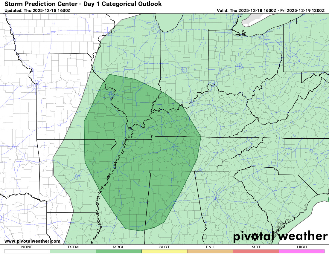
A few severe storms with damaging winds or a tornado could occur as a band of storms evolves along the cold front associated with this storm system. A marginal (level 1 of 5) risk is in place from the Storm Prediction Center as shown above.
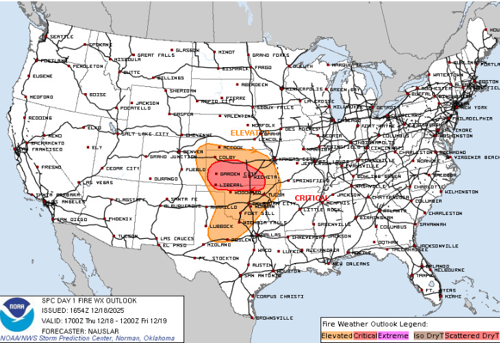
Over the central and southern Plains, the strong winds will combine with dry air and recent lack of rainfall to support widespread elevated to critical wildfire danger today.
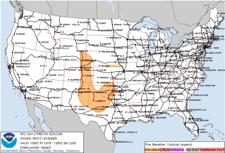
Strong downslope winds are expected again Friday to the lee of the central and southern Rockies, which will result in additional elevated to locally critical wildfire danger.
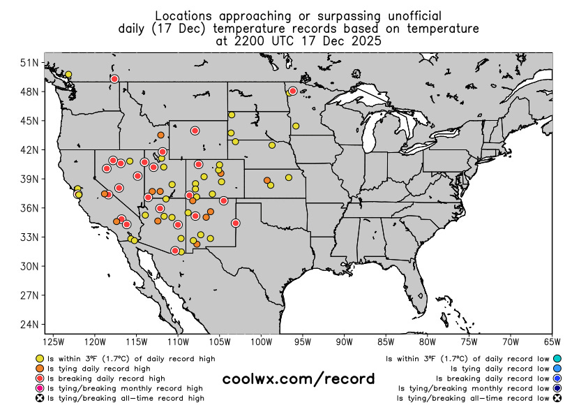
The other big weather story the last 24 hours was the record warmth which continues unabated across much of the western half of the country. Among the numerous record highs on Wednesday was Salt Lake City shattering its daily record, reaching 67F (previous record was 58 in 1939). This tied for the second warmest temperature ever observed in Salt Lake City in the month of December (69F is the all-time record set December 1 1995).
The unseasonable warmth looks to continue across this region for the foreseeable future, with Friday (shown above) seeing another peak in record warm temperatures across the region. The Northeast also should see a number of record highs ahead of the storm system I talked about above which will bring a quick shot of cold air to the East into the first part of the weekend.
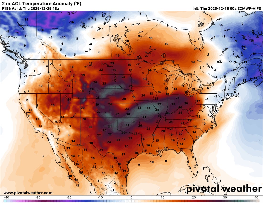
Unseasonable and at times record warmth for much of the nation will be one of the dominant weather stories for Christmas week. The above surface temperature anomaly forecast for Christmas Day from the European AI model shows widespread well above normal temperatures for most of the country, with temperatures of 30 to 35F above normal across much of the central part of the nation. This would likely result in numerous record high temperatures. The one part of the country that will likely remain vulnerable to colder shots of air next week will be the Northeast, and particularly northern New England into Maine. Even here, though, warm air will infiltrate the region periodically.
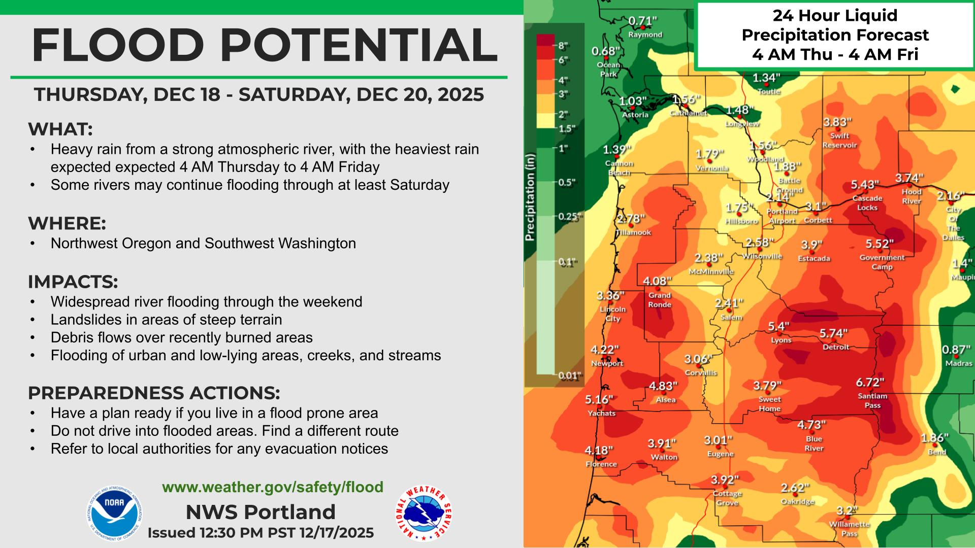
The other big weather story heading into the holiday week will be the seemingly endless barrage of wet storm systems into the West Coast. The next event will be occurring over the next 48 hours, with western Oregon being the primary focus as discussed in this graphic from NWS Portland. As of now, the Clackamas and Hood rivers are forecast to have the most significant river flooding, with points on both of these rivers forecast to reach major flood stage.
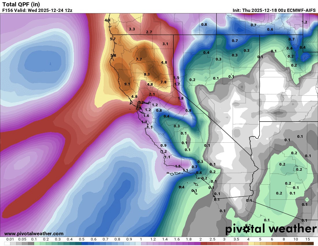
The focus for these atmospheric river fueled systems will drift south over the weekend and into next week, with northern and central California expected to be the primary region impacted. Above normal temperatures will mean high snow levels again and that much of this precipitation will fall as heavy rain through the first part of next week. By the middle of the week snow levels should fall enough to start resulting in heavy snow at mountain pass levels, meaning impacts for people planning travel through the northern and central Sierra. Even then, though, snow levels will likely remain above 6000 feet and significant rainfall will continue below that level. We will be watching the model trends closely for these systems as far as potential impacts next week.

Leave a comment