Extreme wildfire danger today in the foothills of Colorado and southeast Wyoming, while California braces for an onslaught of heavy rainfall
Dec 19, 2025
There is a lot of significant weather to get to this morning, but in case folks missed my late night post just want to recap that last evening the Colorado US Senate delegation put a hold on the legislative process surrounding the remaining 2026 appropriations bills. This was done to pushback against the Trump administration’s announced plans to disband the National Center for Atmospheric Research (NCAR), and according to the senators “to demand full funding for NCAR.” You can get more details in my post from last night.
With Congress now in recess and the impending holidays, there may be a bit of a hiatus in news about this situation for a week or two — but last night’s developments seem to make clear that a longer term political battle about the future of NCAR is looming. Complicating matters is that the NCAR situation is playing out as part of a larger political standoff between the Trump Administration and Colorado’s state and federal Democratic leadership over a variety of issues, but most recently surrounding the president’s efforts to pardon convicted Colorado election clerk Tina Peters. Rep. Joe Neguse (D-CO) is the Congressional representative for the Boulder area, and he has said:
It (NCAR dismantling) has nothing to do with the work that’s being done every day at NCAR … and everything to do with politics and the Trump administration’s general lawlessness, to try to secure the release of Tina Peters, who had been convicted of state criminal offenses in Colorado. This is part and parcel, I think, of a strategy by the Trump administration to retaliate against the state of Colorado.
This perspective was reinforced by comments a Trump administration official made to NOTUS suggesting that the NCAR decision was related to the ongoing feud between the administration and Colorado Governor Jared Polis, saying “maybe if Colorado had a governor who actually wanted to work with President Trump, his constituents would be better served.” Publicly, the administration has framed its decision to disband NCAR and close the Mesa Lab around its climate change and “Green New Scam” research activities. You can read the administration’s full statement to CBS News about NCAR here.
As I and other scientists have repeatedly been saying, climate change research is just a part of what NCAR does, and it is a world renowned research facility that has made tremendous concrete contributions to improving weather and water forecasts. I strongly encourage you to read this excellent piece my colleague Dr. Marshall Shepherd published in Forbes yesterday summarizing just what NCAR is and some of the most important contributions that NCAR has made to meteorology over the years. While the administration says that “vital” weather research activities at NCAR will be “moved under the purview of another entity or location,” I explained in my piece Wednesday why I am deeply skeptical such an approach is viable.
While the Congressional recess and holiday period may bring a break in this saga, I will obviously provide any updated information I learn in the coming days.
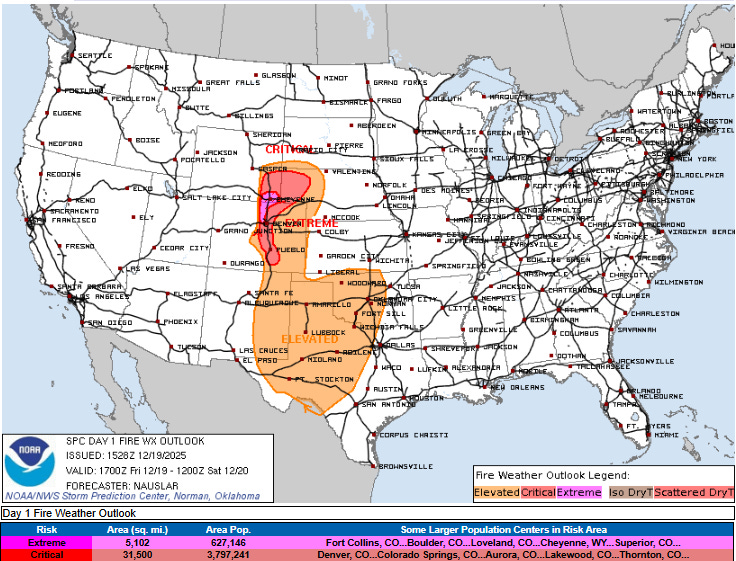
Unfortunately, Colorado is the focus today for hazardous weather reasons as well, as another intense downslope wind event is expected in the Front Range and foothills of the Rockies. Given recent dry conditions and anticipated low relative humidity, this will result in a day of critical wildfire conditions across the region, with the Storm Prediction Center focusing on the foothills region of northern Colorado and extreme southeast Wyoming for extremely critical conditions this afternoon.
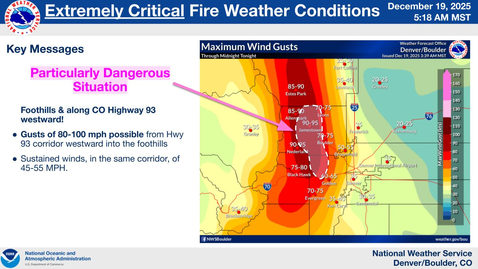
The NWS in Boulder is highlighting the areas above for their highest concern, with potential for wind gusts of up to 100 mph in areas just west of Boulder.
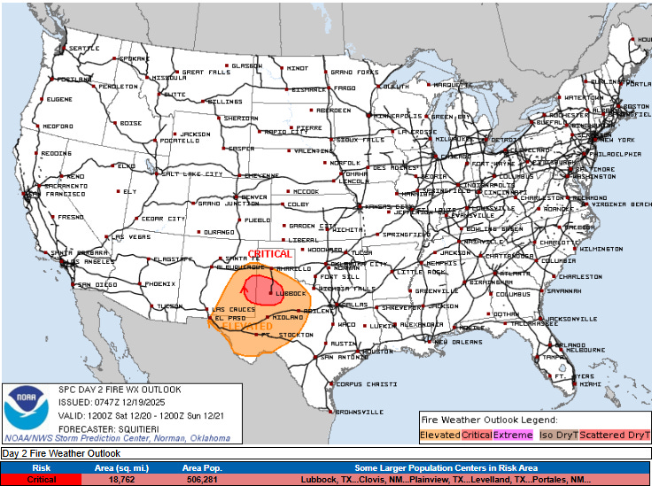
Additional fire danger issues are anticipated on Saturday across parts of New Mexico and Texas. This entire region has been rather dry of late and with warm and dry weather anticipated for the foreseeable future, additional days with fire danger will likely be seen.
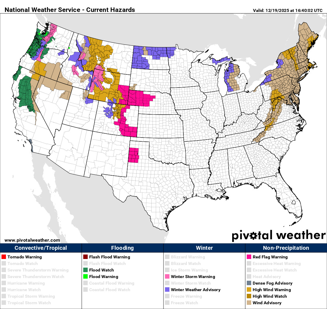
While the storm system moving through the northwest today will not produce as serious and widespread of a high wind event as the one earlier this week, a large area of strong winds is still expected, and wind advisories and high wind warnings are in effect for a number of areas as shown above. Strong winds are also occurring in the eastern United States in associated with the initial strong low pressure system which is now centered in southeast Canada, and wind advisories and warnings are in place here as well.
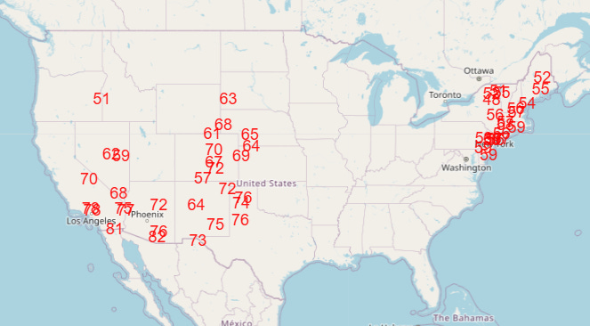
Record warmth is also expected to be widespread over the Northeast today, with continuing numerous record warm temperatures across the western half of the country as well.
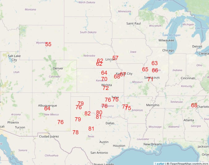
As we have been discussing, while another transient cold shot is spreading across the eastern half of the country the next 24 hours, moving into Christmas week the unseasonable warmth over the western US will spread east to encompass much of the country except parts of the Northeast. NWS forecast temperatures for Christmas Day already show numerous forecast record highs (top graphic), with even more widespread forecast record warm low temperatures (bottom graphic).
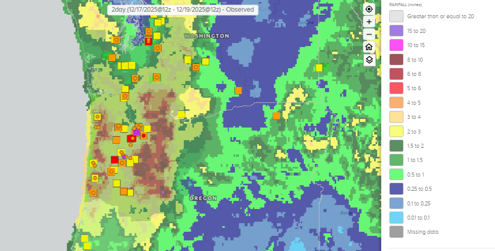
The other major weather story going into Christmas week will be the continued parade of wet storm systems into the West. Over the last 36 hours, the heaviest rainfall has been focused in western Oregon (above), with numerous rivers now in minor to moderate flood stage.
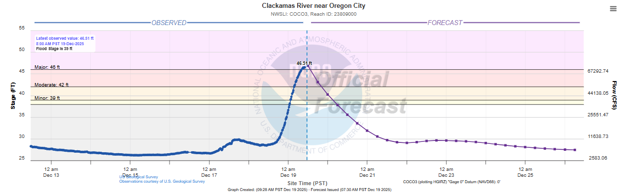
The Clackamas River near Oregon City is cresting at major flood stage, and per the NWS impact statements for this site flooding is likely impacting residences and buildings in the region.
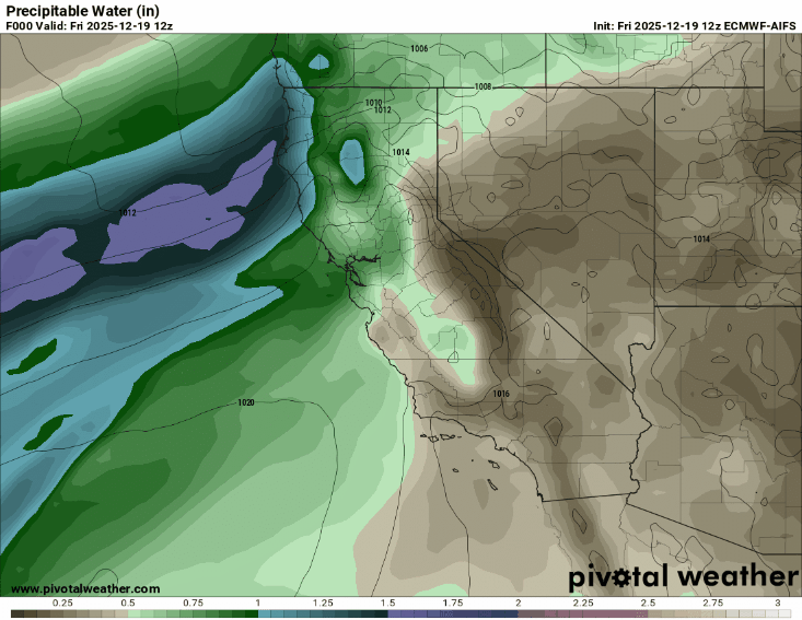
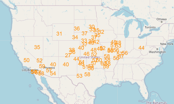
The focus for significant impacts from the continued parade of systems will be shifting to California for the next week, and particularly northern and central California. The animation above shows forecast sea level pressure (contours) and precipitable water (image) for the next 7 days from this morning’s hot off the press European AI model, which generally provides a decent blend of operational and ensemble forecast solutions for illustrative purposes.
For the next several days, while its location varies slightly with time, a “firehose” of moisture focuses into central and northern California which will promote heavy rainfall over the region. These will be warm systems and snow levels will be very high, meaning that as we saw in Washington state last week river impacts potentially be greater than “normal” for winter time storms in this region.
By Christmas Eve and Christmas Day, a much stronger storm system will approach the coast, which will begin to expand heavier precipitation south into southern California, and will also lower snow levels in the mountains down to pass levels, bringing significant travel impacts to the Sierra. While gusty winds will be occurring at times with the storm systems the next few days, this stronger low pressure center will likely bring more widespread and impactful winds to the region.
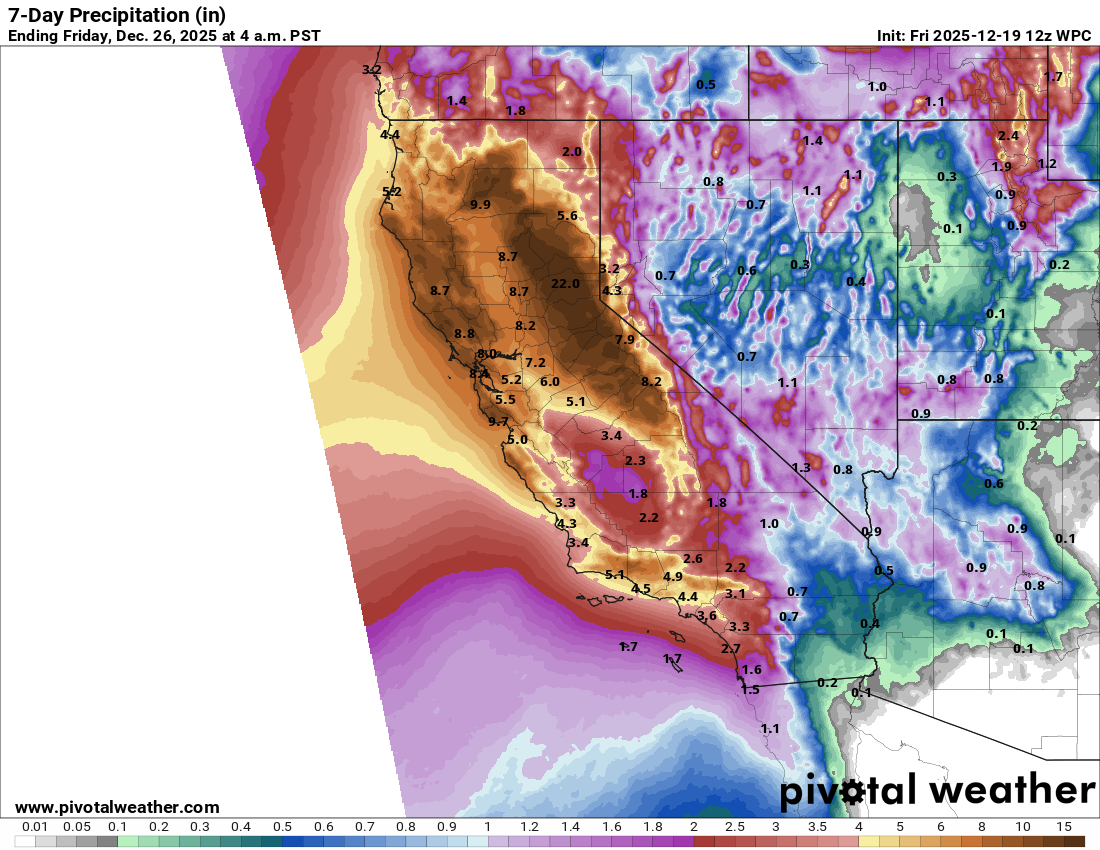
Total precipitation amounts for the next week from the Weather Prediction Center are extremely heavy, with widespread amounts of 5-10” across northern and central California, and amounts up to 2 feet (liquid, not snow!) over the Sierra. Clearly, significant flooding and eventual winter weather impacts are anticipated, and flood watches are already in place.
I want to remind everyone as the West continues to be where the big weather stories are that obviously weather in this part of the country is very dependent upon the complex terrain and local effects. While I try to cover weather in the region as best I can, I do not have the years of experience needed to really dive into some of these localized forecast issues. I strongly encourage you to follow local NWS offices and excellent western US focused meteorologists like Daniel Swain, Jan Null and Anthony Edwards for more in-depth info about this region.

Leave a comment