Christmas week brings heavy rain and flooding to California and widespread unseasonable warmth to much of the nation
Dec 21, 2025
Happy Sunday! Flooding is an issue again already this morning in California, and will only become a bigger issue in the coming week. Before I dive into all of that, I want to share this story I happened to see this morning from Fox13 in Seattle about the flood alerting during last week’s breach of the Desimone levee on the Green River near Kent, WA.
The National Weather Service is tasked with issuing flash flood warnings when urgent situations like dam and levee breaks occur — typically these situations pose an imminent threat to life and property just like a flash flood directly caused by heavy rainfall, and as such a warning is warranted. While the NWS can provide hydrologic support to local officials in situations like this about potential inundation impacts, generally speaking these warnings are closely coordinated with county and municipal emergency managers and local officials given that they have more detailed information about the nature of the threat and expected impacts.
BULLETIN - EAS ACTIVATION REQUESTED
Flash Flood Warning
National Weather Service Seattle WA
1151 AM PST Mon Dec 15 2025

The National Weather Service in Seattle has issued a

* Flash Flood Warning for...
  A Dam Break in...
  West Central King County in west central Washington...

* Until 900 PM PST Monday.

* At 1151 AM PST, county dispatch reported the failure of Green
  River Levee causing flash flooding near the Green River in
  Tukwilla.

  HAZARD...Life threatening flash flooding from the failure of
           Green River levee.

  SOURCE...County dispatch.

  IMPACT...Life threatening flash flooding of areas near Tukwilla
           along the Green River levee .

* Some locations that will experience flash flooding include...
  Kent, Renton and Tukwila.

This includes the following streams and drainages...
  Green River, Duwamish Waterway and Cedar River.

PRECAUTIONARY/PREPAREDNESS ACTIONS...

If you are in low lying areas below the you should move to higher
ground immediately.

Move to higher ground now. Act quickly to protect your life.

&&

LAT...LON 4742 12220 4743 12226 4745 12225 4746 12225
      4748 12225 4748 12221 4746 12220

FLASH FLOOD...OBSERVED
FLASH FLOOD DAMAGE THREAT...CONSIDERABLE
DAM FAILURE...OCCURRING

$$

JBB
This is the actual flash flood warning that was issued by the National Weather Service in Seattle for this levee breach situation. As I have talked about in earlier articles about flash floods, the NWS issues three levels of flash flood warnings: base (lowest level), considerable (life threatening) and catastrophic (emergency). The considerable and catastrophic levels alert cell phones in and near the warning area outlined by the NWS through the Wireless Emergency Alert System operated by FEMA and the FCC.
In her interview with Fox13, the mayor of Kent expressed serious concerns about the NWS warning, particularly the fact that “dam failure” wording was used because while the flooding was a serious concern, it was slower developing than a true dam failure. She also expressed concern that the message from the NWS distracted from their own local efforts to make targeted emergency notifications about the situation with their Code Red notification system, and “caused panic” that resulted in unnecessary evacuations that complicated their efforts to get resources to the breach site to work on repairs.
I strongly encourage you to watch the story — the mayor’s concerns seem very reasoned and well thought out. I am not going to try to comment on the details of this situation and where responsibility may lie, because obviously there was a lot going on here that we do not know and communication and coordination in emergencies like this is always challenging. What I will say, though, is that whatever the reasons, there obviously was some level of coordination and communication breakdown here among the various responsible entities — and that is a recurring theme in many of these flash flood situations. It was definitely an issue in the July 4 Texas Hill Country flash flood, and likely was a contributing factor to the unfortunate large death toll.
Luckily, whatever breakdown occurred with the Desimone levee breach does not appear to have directly lead to any loss of life. However, it serves as a reminder of the complexity of flooding as a hazard, the number of agencies and officials involved at all levels of government from federal to local, and the importance of effective collaboration and coordination among these various entities. It is also important to recognize that for the most part, there are no common standards, policies or protocols for these interagency collaborations. It is generally left to the various entities to determine the mechanisms of communication and collaboration that are necessary, and for the agencies to police themselves.
Having been an intimate part of this world in a variety of locations and roles over the years, I have seen the pros and cons of this system. The pros are that developing these important cross-level, interagency relationships is relatively free of bureaucracy. The cons, though, are that there is very little structure or oversight, and as a result you get a wide variance of communication and collaboration protocols and systems — and a wide variance in the efficacy, from the very effective interagency real-time flood mitigation effort along the Skagit River I talked about last week to concerning levels of communication and coordination like the Desimone levee and July 4th flash floods.
While I would hate to see the work of these agencies get mired in overly heavy bureaucracy, I do think there needs to be much more structure and oversight into how this important interagency collaboration happens, and to require common procedures and systems to alert the public in emergency situations. Right now, the alerting process — whether for Amber alerts, weather hazards or other local emergencies — by state and local governments is very much a wild west situation, and I encourage you to look at the blog of my colleague Dr. Jeannette Sutton who writes extensively about the issues that this chaotic environment causes.
A big reason why I am so concerned about the administration’s plans to reduce FEMA is that from my perspective FEMA’s oversight role in this area likely needs to be increased, and a smaller FEMA is likely not going to be able to do that. Furthermore, what I am talking about here today is why I am so supportive of the idea of a National Disaster Safety Board (NDSB). Preparedness and response to these weather and water events are the result of a complex interaction of political, physical science and social science factors. If we are serious about having better preparedness and response, we must examine these disaster events critically and in an interdisciplinary and interagency manner. The National Transportation Safety Board (NTSB) has been an incredibly effective force for dramatically improving transportation safety in this country — we need to replicate it in disaster safety with an NDSB.
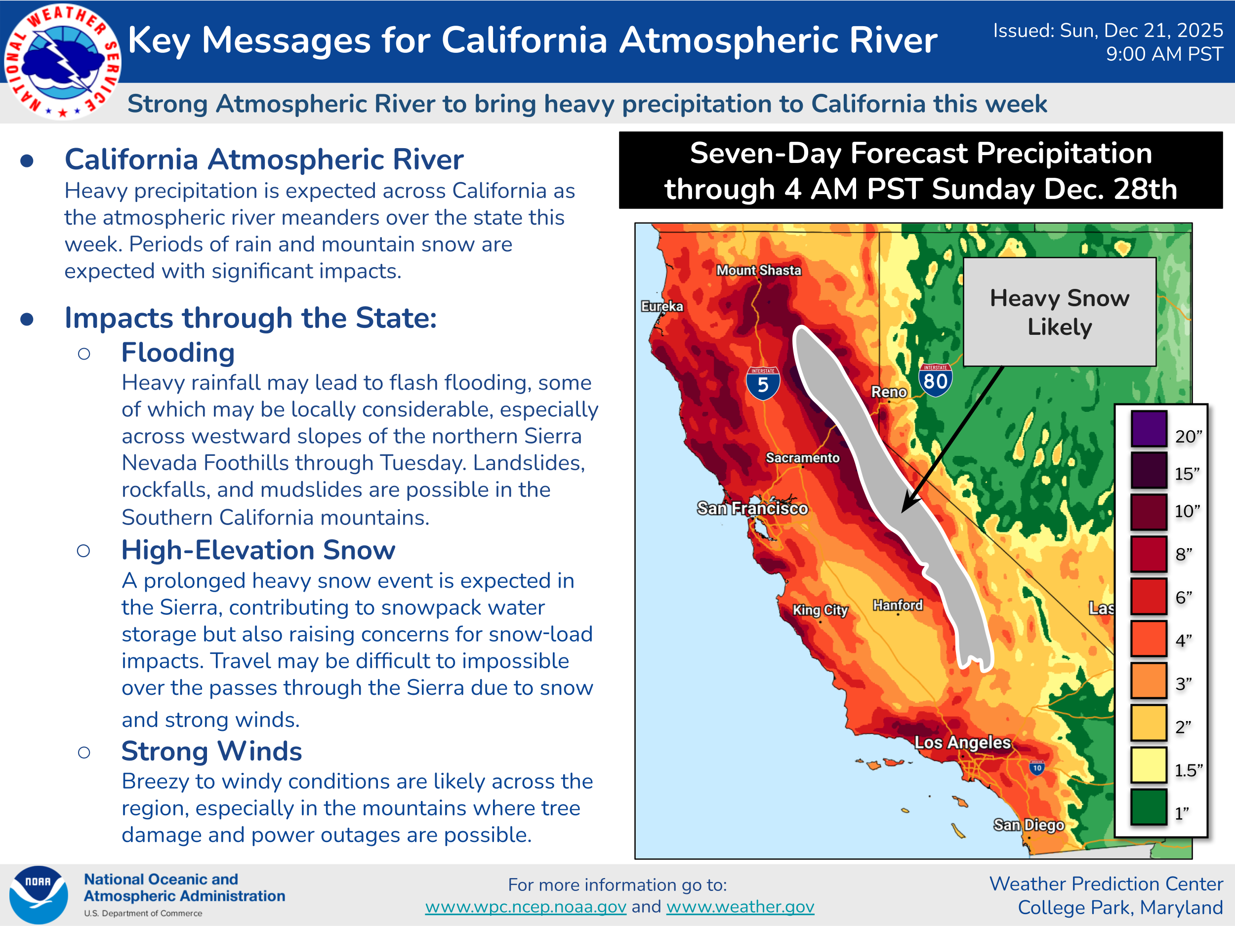
Turning to the current flooding situation, heavy rain is currently ongoing in northern California, particularly the higher elevations where 3 to 5 inches of rain has fallen in many spots in the last 12 hours. Some debris flows and mudslides have already occurred, and these sorts of events along with other incidences of flash and urban flooding will only become more of an issue as additional waves of heavy rainfall occur in the coming days.

For the next few days, this will once again be a warm precipitation situation with high snow levels of most of the precipitation falling as heavy rain across northern and central California. By Christmas Eve and into Christmas Day, a very intense low pressure system will likely develop off of northern California and move slowly toward the coast. This should cause snow levels to fall in the Sierra Nevada, resulting in very heavy snowfall that will seriously impact travel across the mountains. This system will also result in heavy rainfall spreading south into southern California along with heightened potential for very strong winds in many parts of the state.
The other big story this holiday week will continue to be the unseasonable warmth. Numerous record high temperatures were set again across the southwest third of the country on Saturday. This warmth will expand to encompass much of the country this week — though the Northeast will continue to see occasional incursions of colder air.
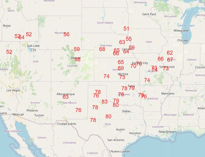
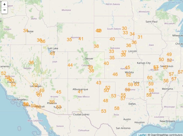
Numerous record warm temperatures are expected through the week, with the peak coming in Christmas Day when numerous record highs (top graphic) and record warm minimums (bottom graphic) are forecast across a large swath of the western two-thirds of the nation.

Leave a comment