Northern California already seeing significant flash flooding, and issues will expand and grow to encompass much of the state this week
Dec 22, 2025
Plenty of weather to talk about again today, but I want to start with some follow-up on my post yesterday about the concerns raised by local officials about alerting and communication regarding a levee breach near Kent, WA during record flooding last week. Not surprisingly, my post and the included story from FOX13 in Seattle generated a lot of discussion on my various shares on social media, and I want to dive deeper into some of the comments and questions.
I want to start by reiterating my point that while it seems clear there were communications breakdowns that led to inconsistent messaging about the threat posed by this levee breach, it is very much not clear where those breakdowns may have occurred. The mayor of Kent raised questions about the NWS flash flood warning, particularly the use of “dam break” wording and the generalized threat language which led to the FOX13 story. However, it is important to recognize that the NWS warning states that it was based on information from “county dispatch.” Without knowing the details of the communications and coordination between all of the NWS and all the various county and municipal entities in involved, there is no way to know where potential miscommunication occurred.
As one of my colleagues pointed out on BlueSky last night, where she lives she can receive alerts from four different government entities, and that each of these could potentially use different wording about the same threat. Obviously, if consistent messaging is to happen in that type of an alerting environment, effective, efficient coordination is vital. Emergency management exists to facilitate that sort of communication and collaboration — and this is one of the reasons why I am so concerned about the future of FEMA and the underlying emergency management structure in this country.
The importance of effective real-time coordination and collaboration is only going to grow in the social media driven communication environment that is becoming dominant in this country. While FEMA and the emergency management structure clearly need reform, this reform needs to be intentional and take into account the realities of the world we face. The quality and efficacy of state, county and municipal emergency management programs already varies greatly across the country. It is hard for me to see how reducing and marginalizing FEMA and putting even more responsibility for emergency management on the state and local level improves that reality.
Great interview with the mayor. Questions emerge: was the city in touch with local WFO? Does the city have reputation for issuing timely messages to locals using CodeRed? Did the city have consistently updated socials? Was WFO on chat about plans to issue WEA? Does WFO have local geo knowledge? I ask these because it could be both sides needing better coordination. And you point abt TX stands – the WFO was the most vocal in absence of local alerting. Whatever happened to IWTs? Are those still active with the reduction in force?
Furthermore, cuts to core agencies like the NWS are certainly not helping the situation either. One of my colleagues raised the above excellent questions on BlueSky about the coordination that occurred around the levee breach — and the questions about the NWS side of this would all potentially be affected by having sufficient staffing and resources to do things like be active on NWSChat (the NWS instant messaging system that connects the NWS and core partners, read more here) and lead Integrated Warning Team (IWT) meetings. IWTs are an ongoing effort that most NWS offices lead to bring together core partners such as emergency managers, broadcast meteorologists, and state and local officials to improve coordination and collaboration. Obviously, if offices are so short staffed that they are having difficulty maintaining 24×7 operations and doing routine balloon releases, activities like IWTs have almost certainly been greatly reduced at many (most?) NWS offices.
Most of the public is unaware of the complex federal infrastructure that exists to keep them safe from the impacts of threats such as hazardous weather, flooding, earthquakes, etc. The very complexity of that system can be problematic at times, and undoubtedly there are ways that it could be improved. However, in my opinion what we have witnessed so far in the Trump Administration is not an effort to improve this infrastructure — what we have seen is a wonton slashing of this crucial framework with little forethought. As long as this is the path we continue down, during major disasters like the Washington flood we will see many more concerning situations like the levee breach alerting and increasingly fewer success stories like the reduction of flooding along the Skagit River.
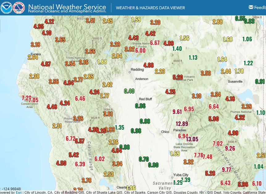
Widespread heavy rain has been pelting northern California over the weekend, with amounts of up to a foot or more in some of the higher elevations of the Sierra (48 hour totals above). This heavy rainfall has been causing significant impacts from flash flooding. Numerous water rescues been needed in the area and flooding and mudslides have impacted many roads. The area around Redding appears to be the hardest hit area, with one person reported killed by flash flooding.
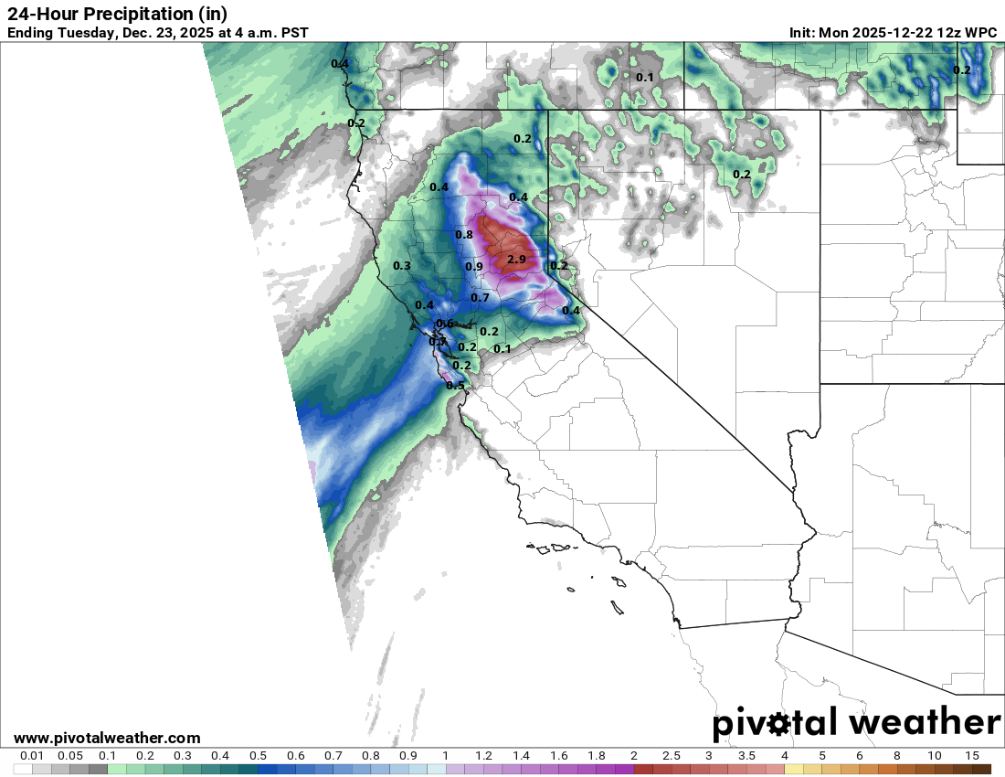
Heavy rainfall will continue today across the northern Sierra, with snow at the highest elevations.
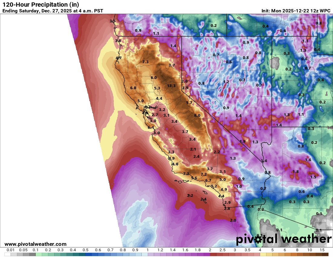
Heavy precipitation will dramatically increase in coverage and intensity across much of California and surrounding areas during the middle and latter part of the week as a series of storm systems impact the region. Snow levels will gradually fall, which will mean very heavy snow down to pass levels resulting in travel across the Sierra becoming difficult if not impossible. However, temperatures will still be near to above normal during much of this heavy precipitation, meaning that heavy rainfall and flooding issues will likely be the dominant impact for most areas this week.
The first storm system looks to begin developing well southwest of California Tuesday afternoon, and will move north northeast and strongly intensify as it approaches the northern California/southern Oregon coastline. Along with an expansion in heavy rainfall, this intense low pressure system will likely bring significant wind gusts of 60 mph or greater across a large area from the central California coast — including the Bay Area — north into Oregon with higher elevations becoming increasingly susceptible to strong winds as well as one goes north. High wind watches are in effect for many of these areas from late Tuesday into parts of Wednesday.
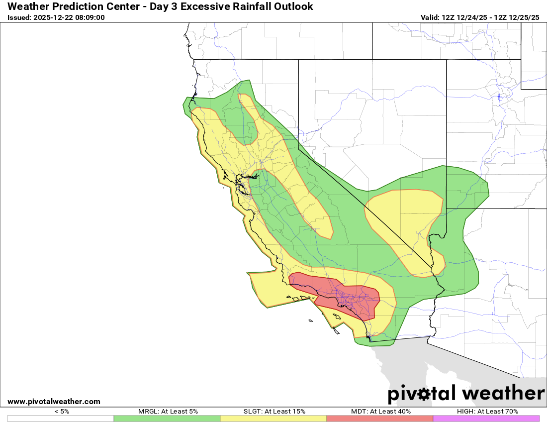
This storm system and a trailing storm system that will impact the region Christmas Eve into Christmas Day will also expand the heavy rainfall threat to include southern California and parts of the desert Southwest. The Weather Prediction Center has already hoisted a moderate (level 3 of 4) risk of excessive rainfall for southern California including the Los Angeles metro area.
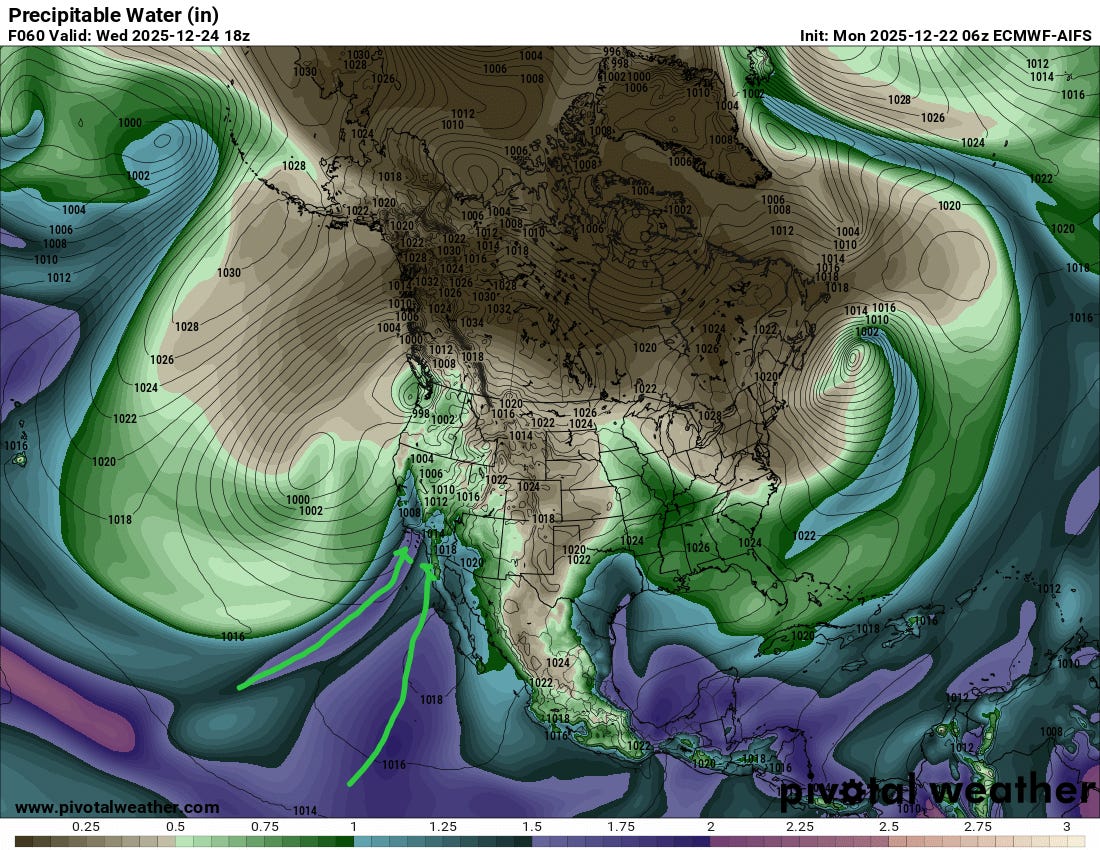
By Christmas eve, southern California looks to come under the influence of two distinct flows (“rivers”) of atmospheric moisture from the deep tropics as shown in the image above. This could result in widespread, very heavy rainfall totals with potentially significant flooding impacts.
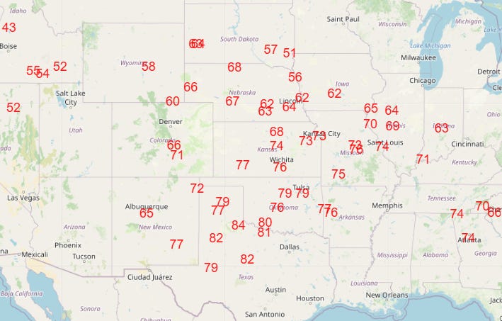
The record warmth continued Sunday, with a number of record highs again over the southwest third of the country. That warmth will continue to expand through Christmas Day, with numerous records expected (above) on what will likely be one of the warmer Christmases on record for the US. This unseasonably warm weather for most of the country (Northeast least impacted) will likely continue through at least the end of this week before the next cold front finally starts to bring some cooler air to at least the eastern half of the country.
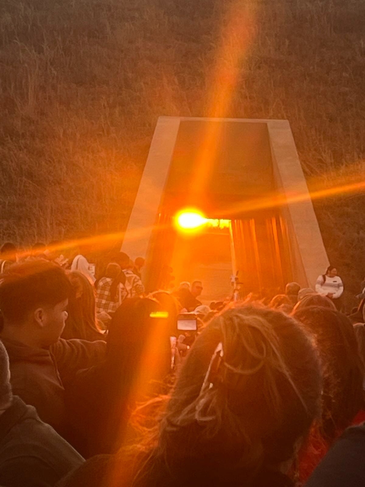
Finishing off with a picture to remind everyone that we are now truly and “officially” in winter, as the winter solstice was this weekend. I had the opportunity to be at the First Americans Museum in Oklahoma City for sunset last night and watch the sun descend into the tunnel in the mound there that recreates the astronomical calendars that Native Americans constructed in pre-contact era. My cell phone picture is not great, but hopefully you get some sense for what an incredibly moving experience this was. You can read more about the solstice celebrations at the First Americans Museum here.

Leave a comment