Next in series of storm systems into California will likely be most impactful with potential flooding and strong winds through Christmas Eve, while incredible late December warmth spreads east
Dec 23, 2025
Good morning and Merry Christmas Eve Eve! Starting off this morning with a quick update on the Trump Administration plans to dismantle the National Center for Atmospheric Research (NCAR) in Boulder, CO, and the growing opposition to the move. NOTUS reported yesterday that four Republican congressmen joined nearly 80 Democratic House and Senate members to sign a letter to the appropriation leadership in both chambers urging full funding for NCAR.
A statement released by the office of Rep. Joe Neguse (D-CO), the representative for the Boulder area, said:
Today, Colorado Representatives Joe Neguse (D-CO) and Jeff Hurd (R-CO) and Michael Bennet (D-CO) and John Hickenlooper (D-CO) led a bipartisan, bicameral coalition in support of sustained funding for the National Center for Atmospheric Research (NCAR) in Boulder. In a letter to congressional appropriators, 80 lawmakers from across both chambers requested statutory language be included in the Fiscal Year (FY) 2026 Commerce, Justice, Science, and Related Agencies funding bill to prevent its dismantling and ensure NCAR can maintain its core capabilities and continue delivering vital Earth system science.
Rep. Jeff Hurd, who represents southern and western Colorado including Grand Junction and Pueblo, was one of the four Republicans who signed the letter, and said in the statement released by Neguse’s office:
NCAR does critical work in Colorado that helps predict severe weather and keeps America competitive in climate science. The research happening there protects communities and supports our national security. Dismantling this institution doesn’t make sense, and I’m glad to work with my colleagues in both chambers to make sure NCAR has the funding it needs to keep operating. The scientists at NCAR are doing work that matters – work that helps families prepare for storms, helps farmers plan their seasons, and keeps us ahead on the world stage. Supporting NCAR is a smart investment we should continue to make, not walk away from. I’m grateful to my House colleague, Joe Neguse, for his partnership in protecting an institution that matters to Colorado and the country.
The Commerce, Justice and Science (CJS) appropriations bill that funds the National Science Foundation (NSF) — NCAR’s funding agency — is one of five remaining funding bills being worked by Congress in advance of a January 31 deadline. (CJS is also the funding mechanism for NOAA and NASA.) This Congressional coalition is seeking to ensure that language is included in this bill that would adequately fund NCAR. In their letter, the coalition notes that the President’s own budget request for NSF states the important role that NCAR serves:
As the Budget request states: “The National Center for Atmospheric Research (NCAR) is an NSF-sponsored Federally Funded Research and Development Center (FFRDC) guided by the vision: ‘a world-class research center leading, promoting and facilitating innovation in the atmospheric and related Earth Systems sciences.’ NCAR addresses this vision with integrated research and facilities organized around three overlapping areas of activity: cutting-edge airborne and ground-based observational facilities; community weather and climate models with thousands of users worldwide; and petascale high-performance computing.”
Finalizing and voting on the remaining funding bills will be a priority for Congress when they return to session after the holidays, and we should learn much more about the future of not only NCAR but also NOAA, NASA, and NSF as the process to finalize the CJS appropriations bill proceeds. Some additional perspective about the push to #SAVENCAR can be found in a post by Andy Revkin, who wrote about a protest that occurred at the NCAR Mesa Lab over the weekend.
The political wrangling about NCAR is occurring against the backdrop of very active and unusual weather across the nation for this holiday week, with a series of storm systems expected to bring several days of high impact weather to California and parts of adjacent states, while much of the rest of the nation looks to set to experience one of the warmest Christmas holidays on record.
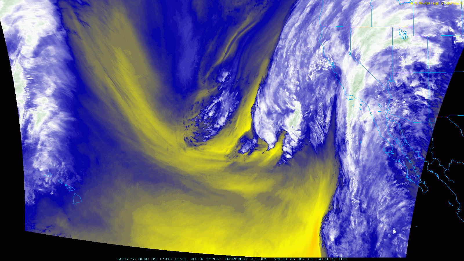
Starting off out West, morning satellite imagery of water vapor shows a series of strong upper level weather disturbances rotating around a deep dip in the jet stream, with the disturbances destined for California on the eastern side of the jet stream dip. Meanwhile, you can clearly see that a deep flow of moisture from the tropical eastern Pacific is streaming into southern California and the Desert Southwest.
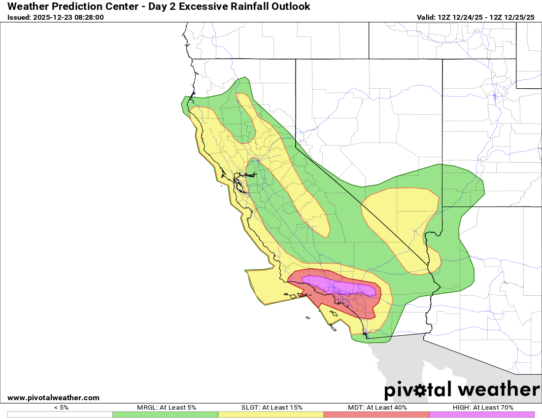
The initial strong upper level disturbance is beginning to generate a low pressure system at the surface to the southwest of California. This system will intensify and move northeast toward the northern California coast over the next 24 hours. The combination of this system and the deep flow of tropical moisture will result in very heavy rainfall across southern California over the next 36 hours, with the heaviest amounts expected in the east-west oriented mountains and foothills in the northern part of the Los Angeles metro area. The NWS Weather Prediction Center (WPC) has placed a high (level 4 of 4) risk of excessive rainfall in this area for Christmas Eve, with much of the southern California metro corridor in a moderate (level 3 of 4) risk.
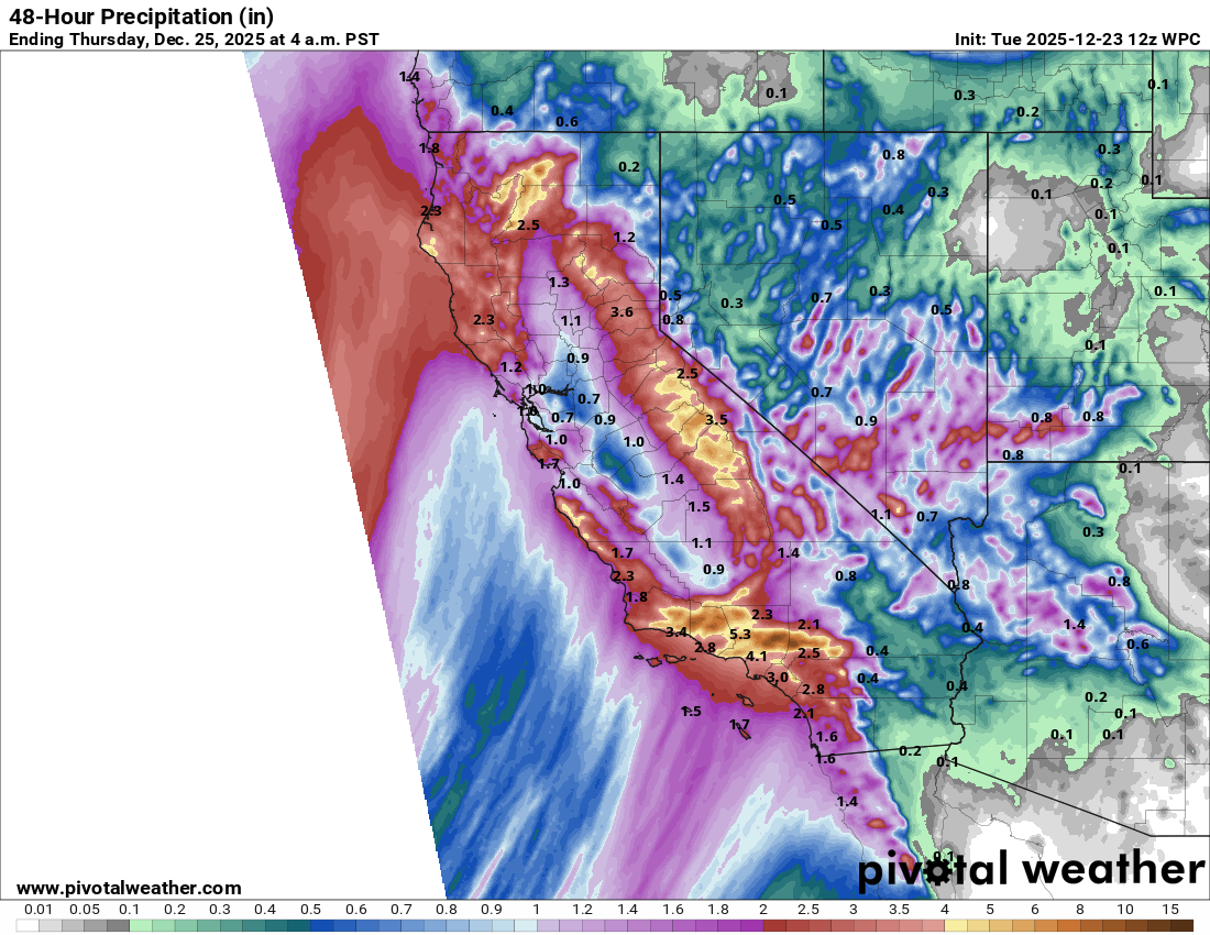
WPC forecasts — supported by the morning run of the High Resolution Ensemble Forecast (HREF) — shows widespread rainfall of 3 to 7 inches through Christmas morning across the region, with amounts of 8-15” across the higher terrain where the high risk is in place. The HREF suggests isolated 20” amounts are possible in this area.
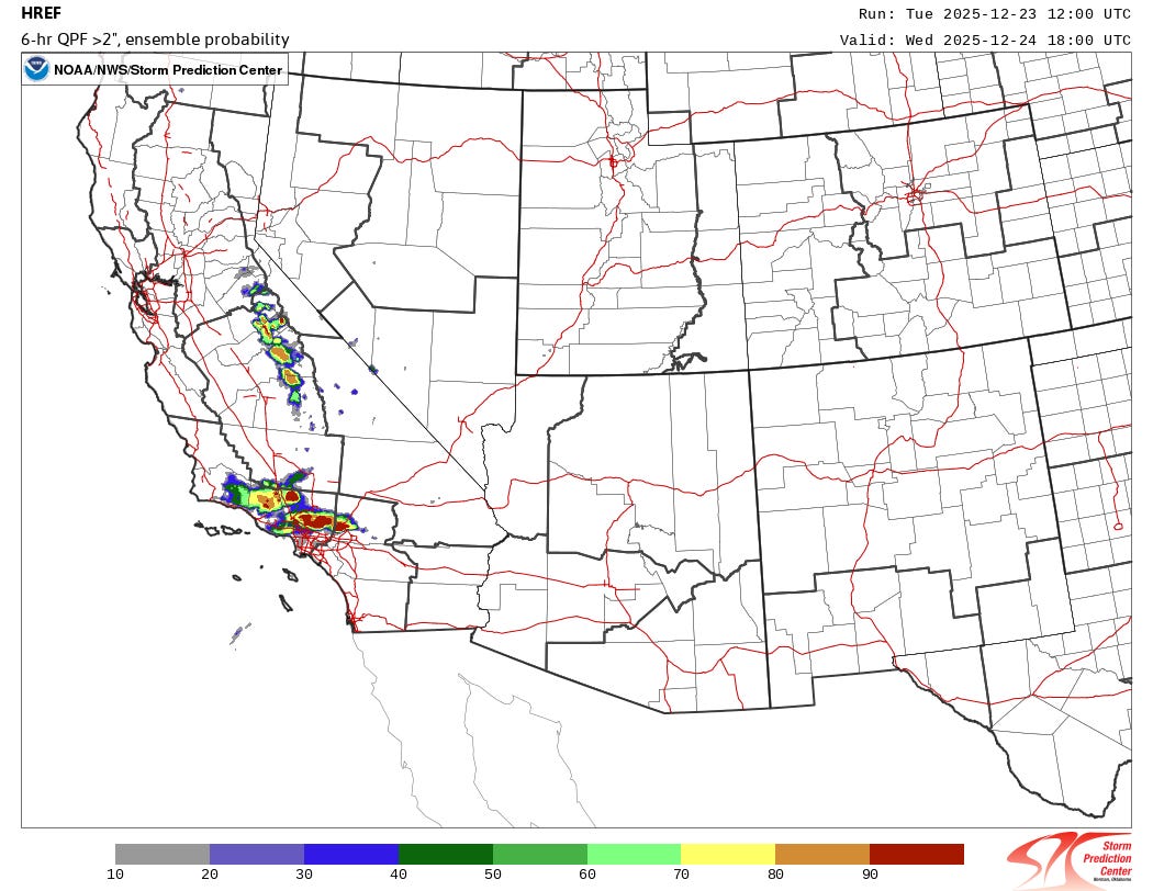
The HREF shows the highest rainfall rates impacting southern California late tonight and into Wednesday morning, with high probabilities of 2+” in 6 hours in the higher terrain just north of LA. These types of rainfall rates could cause landslides and mudslides as well as debris flows in burn scar regions. Evacuation orders are in place for some burn scar areas.
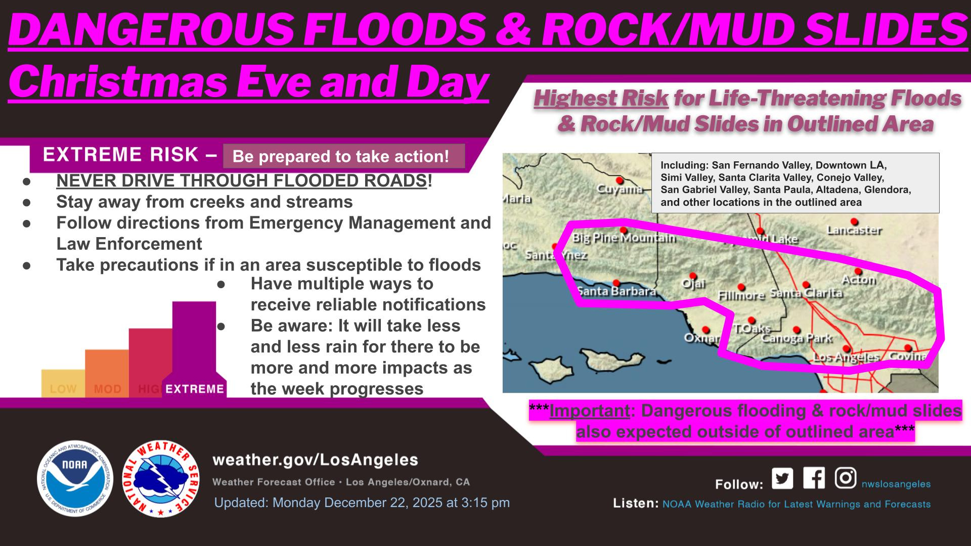
While Wednesday morning looks like the peak in rainfall rates with this first system, moderate to heavy rainfall will be prolonged and last into Christmas Day, so significant flooding impacts are likely to continue, including potentially widespread urban flooding. Given the amount of people likely planning holiday travel, this is obviously a serious concern.
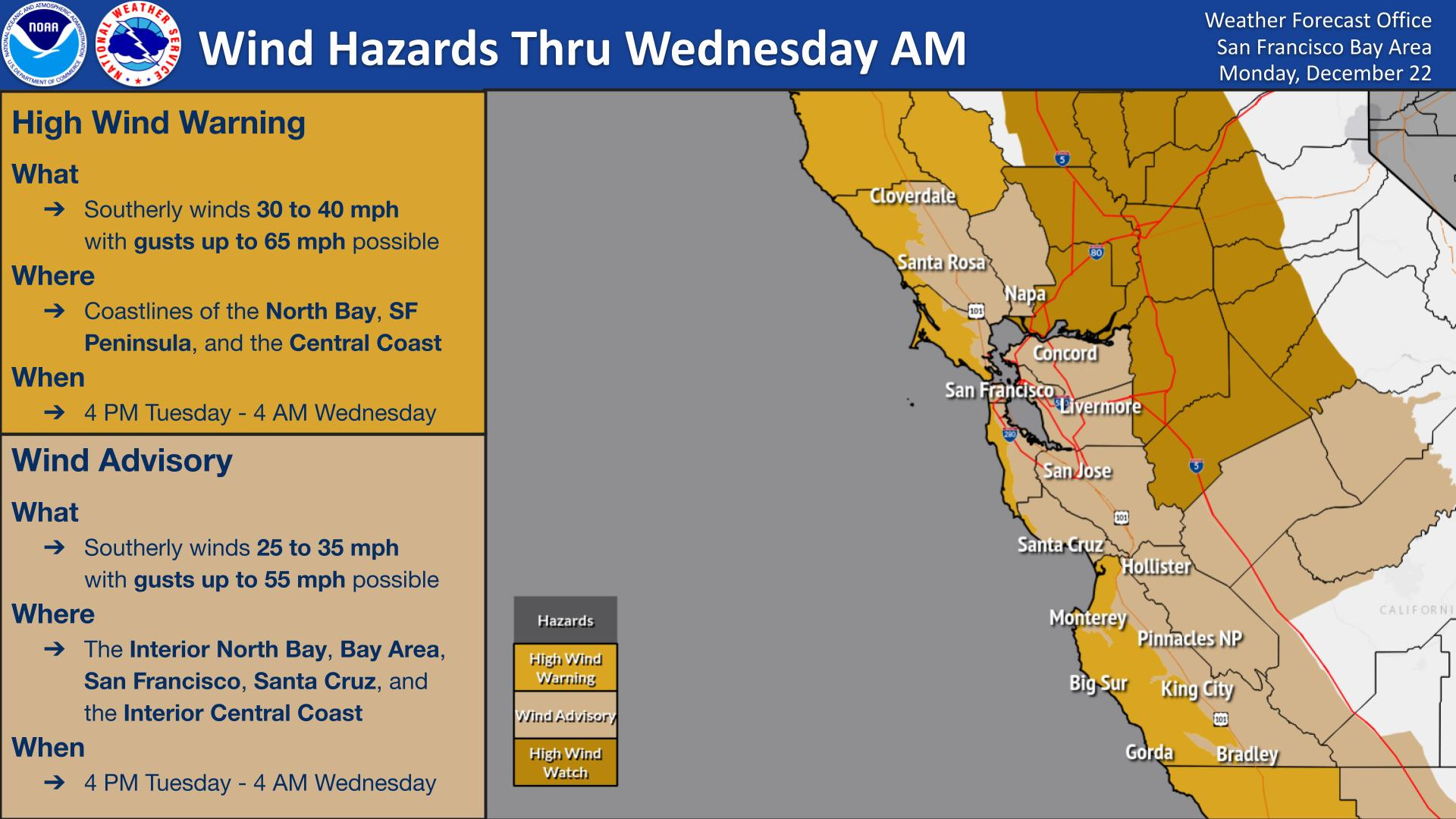
Farther north into central and northern California, this initial storm system will also cause significant impacts, including heavy rain and areas of flash flooding. High winds with potential power outages are also anticipated, particularly along the coast and in higher terrain where high wind warnings are in effect for tonight.
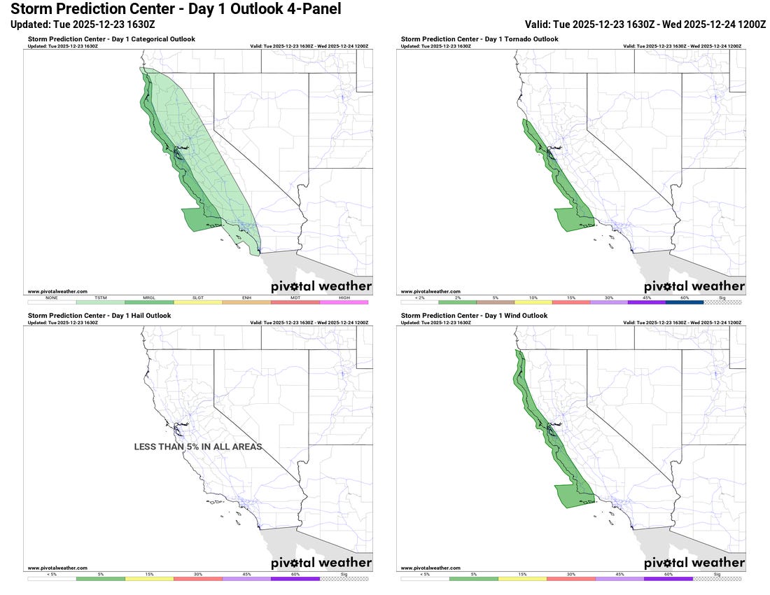
Finally, isolated severe thunderstorms are anticipated with this system. The initial threat of a few severe storms with damaging winds and possibly a brief tornado should evolve late tonight along the northern and central California coast.
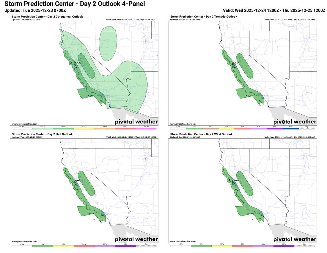
On Christmas Eve the risk will expand to include much of the coastal regions of California as well as the San Joaquin Valley. Damaging winds, 1” hail and a couple of tornadoes are possible with these thunderstorms.
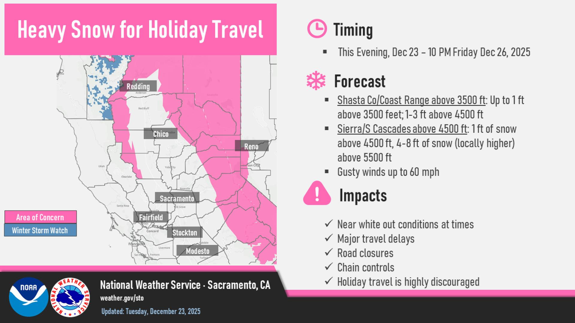
Additional low pressure systems will impact the state Christmas Day into early this weekend. Colder air moving behind the first system will gradually lower snow levels in the Sierra Nevada over the next 48 hours down into the 4000-5000’ range, meaning that very heavy snow will significantly impact travel across and in the mountains as shown above from the NWS office in Sacramento.
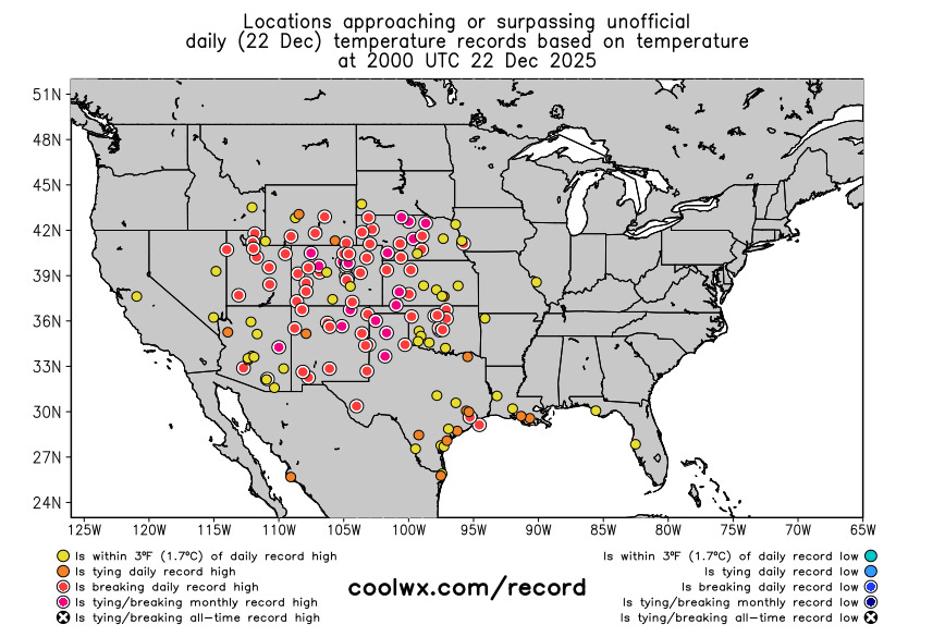
Turning now to the other major weather story, the unseasonable warmth building across much of the country. Dozens of record high temperatures were set on Monday across the central and western United States. As you can see on the graphic above from coolwx.com, some sites even tied or broke monthly December records, which is truly incredible for late December. Monthly records included Amarillo (83F, tied record from 1939), Lubbock (85F, broke record of 83F from 1939), and North Platte, NE (78F, broke record of 76F from — again — 1939).
While I do not have a readily available graphic of record high minimums, the number record high minimums set on Monday is also large, and some of these records are even more insane. Perhaps the most insane is what happened at Salt Lake City. The low temperature on Monday there was 59F, setting a new record by 10 degrees. Amazingly, this low was warmer than the record high temperature for the date — 57F set in 1964. The high at Salt Lake City was 67F — the second highest December maximum on record, and the second time the location has hit 67F in the last week. The minimum temperature of 59F was obviously an all-time record for the month of December — the BlueSky account Extreme Temperatures Around the World pointed out that the record high minimum for November in Salt Lake City is 59F, i.e., the SLC low temperature on December 22nd would have tied the all-time November highest minimum temperature record.
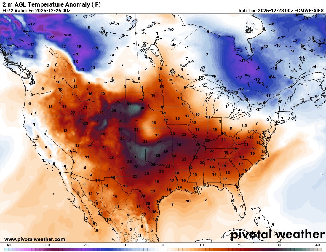
So many record warm temperatures — both maximums and minimums — are forecast over the next week that I am not even going to try to post graphics; you can find maps of the locations with forecast record temperatures at this WPC link. The forecast of surface temperature anomaly from the European AI model for Christmas afternoon shows that the one location not forecast to experience abnormal warmth is upstate New York across New England and Maine.
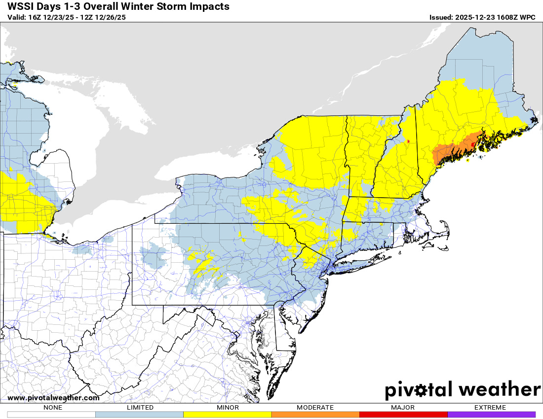
The system that will bring that shot of colder air for Christmas Day will also bring some mixed wintry precipitation to parts of the Northeast through Christmas Eve. As we have been discussing, this region will continue to be prone to occasional shots of cold air — and by the early to middle part of next week a more expansive shot of colder arctic air should bring colder conditions to much of the eastern half of the country.

Leave a comment