Part of the widespread impacts from an intense storm system over the Great Lakes
Dec 29, 2025
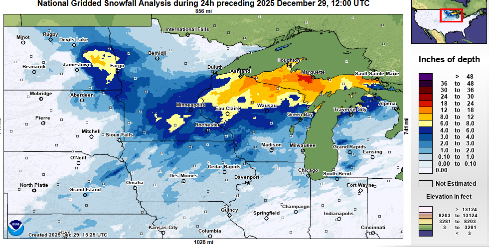
Sunday was an active weather day around the Great Lakes and Upper Midwest. The intense storm system we have been discussing the last couple of days brought heavy snow and strong winds with blizzard conditions in many locations. The heaviest snow (24 hour snowfall analysis from NOAA’s National Operational Hydrologic Remote Sensing Center (NOHRSC) above) fell over the Upper Peninsula of Michigan as moisture from Lake Superior enhanced the snowfall.
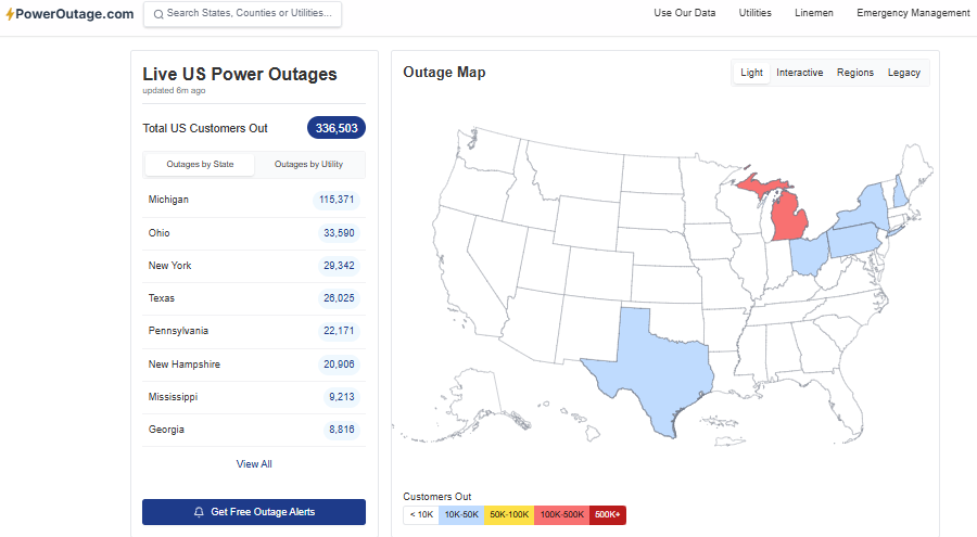
The combination of strong winds, heavy snowfall, and some freezing rain across the northern Lower Peninsula has resulted in more than 100K customers without power this morning across Michigan. In total, about 300K customers are without power in the Great Lakes and Northeast due to the high winds and wintry precipitation.

Probably the most unusual aspect of the weather impacts for a storm system at the end of December was the severe thunderstorm activity. As anticipated, the combination of unusually warm and humid air and the strong atmospheric dynamics resulted in a band of severe thunderstorms along the cold front as it moved through the region. More than 70 reports of severe weather were received by the NWS, mainly damaging winds.
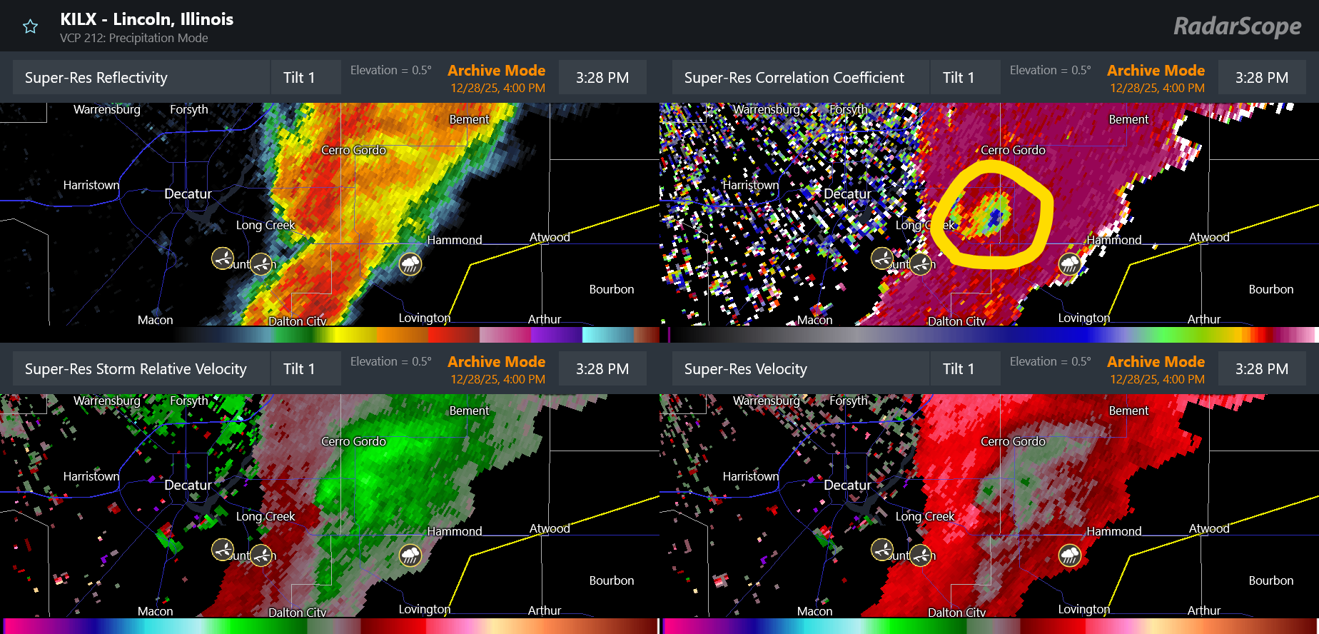
As the severe storms were organizing into a squall line across central and northeast Illinois, they produced several tornadoes. The most damaging tornadic storm appears to have been this one to southeast and east of Decatur around 3:30 pm CT. I have highlighted the location of a well defined tornadic debris signature that was evident in Doppler radar dual-polarization data. The intensity and depth of this signature suggested that significant damage occurred with this storm, and in fact a number of homes sustained heavy damage. Luckily, no injuries were reported.
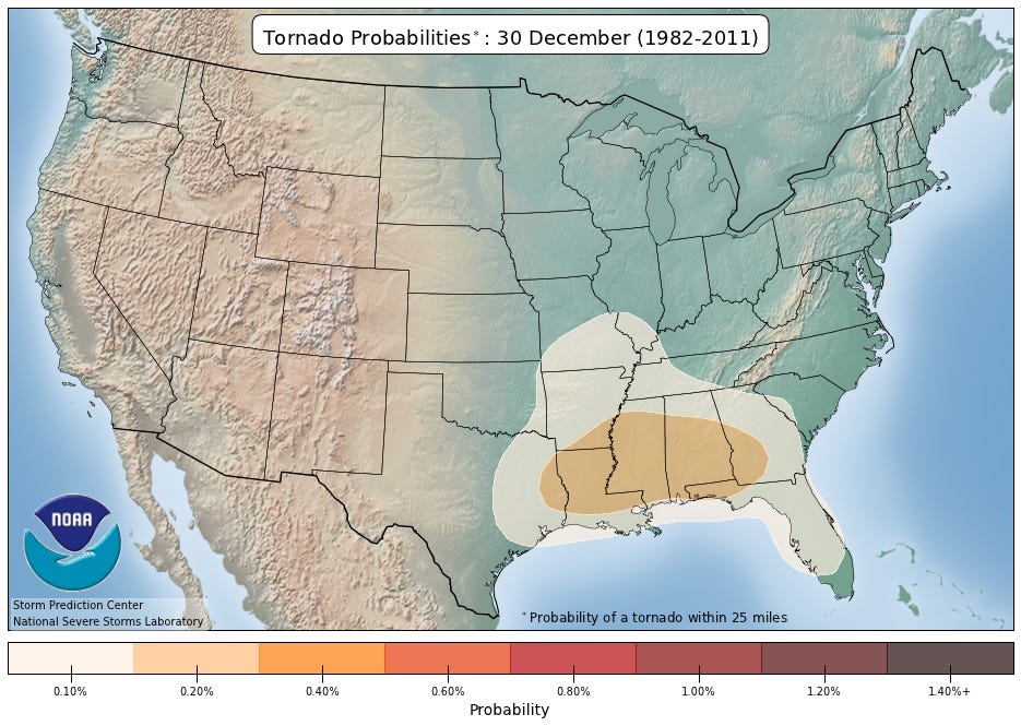
Having tornadoes this far north in late December is quite rare, as this map of climatological tornado probabilities from the NWS Storm Prediction Center for December 30 shows. However, as recently as 2021, an outbreak of tornadoes impacted central Illinois on December 15. This article about the 2021 outbreak from the Illinois State Climatologist notes that even though tornadoes in December only account for 3% of the total tornadoes in the state, they account for 8% of the tornado related fatalities.
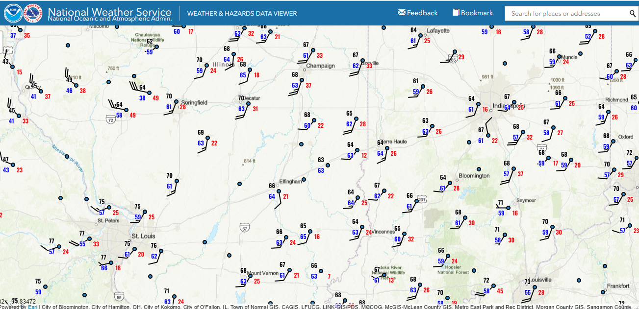
Severe thunderstorms require an unstable atmosphere, which in turn needs a warm and humid layer of air near the surface. Conditions were remarkably warm and humid in central Illinois Sunday afternoon as shown in the 2 pm CT weather map above (temperature is the top left number and dewpoint is the bottom left number for each station). Decatur — the observing site nearest to the tornado discussed above — had a temperature of 70F and dewpoint of 63F at 2 pm, much more typical of a spring day in central Illinois than late December.
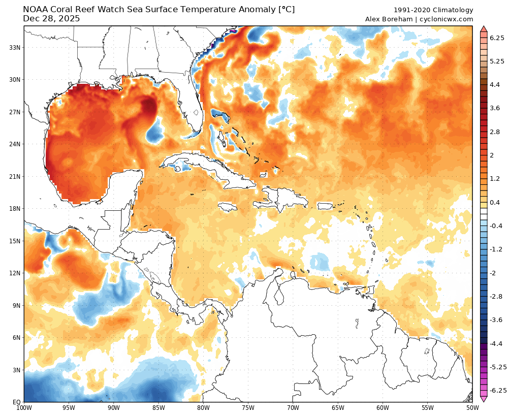
The unusually high dewpoints were likely supported by a much warmer than normal Gulf. SSTs are running 2-3C above normal — in fact, as noted by my colleague Matt Lanza in a recent post, Gulf of Mexico waters are the warmest on record for this time of year. This means that the air flowing from the Gulf will contain more moisture than normal.
All of these factors are consistent with recent research showing that tornado frequency appears to be increasing in the winter and spring months in the Mid-South, Midwest and Ohio Valley regions. As has been noted in this research, it is unclear at this point how much of this change is due to natural variability versus anthropogenic change — although some of the contributing factors such as warmer Gulf waters and more frequent episodes of record warmth are certainly aided by climate change.
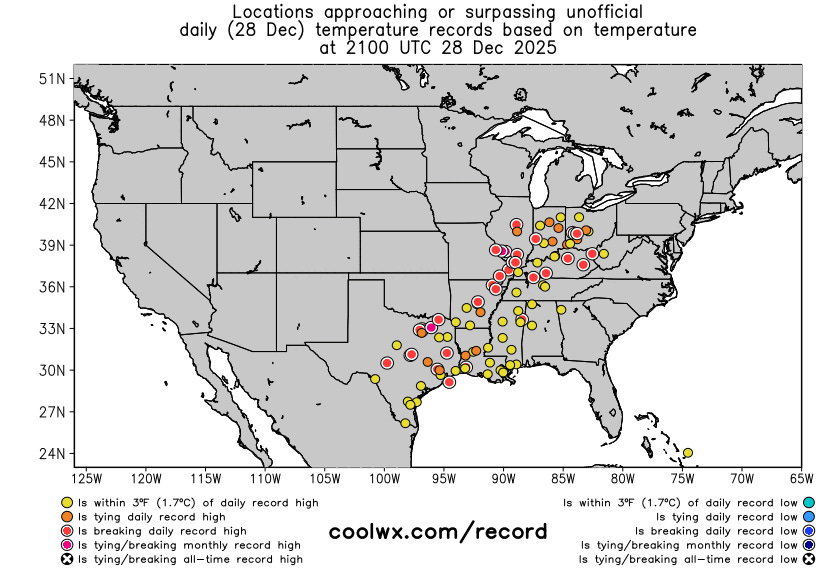
Speaking of record warmth, the last day of this impressive multi-day period of record warmth produced multiple records warm temperatures, again including some all-time December monthly records. St. Louis — with a climate record back to 1874 — broke its all-time December record high by 2 degrees with a temperature of 78F.
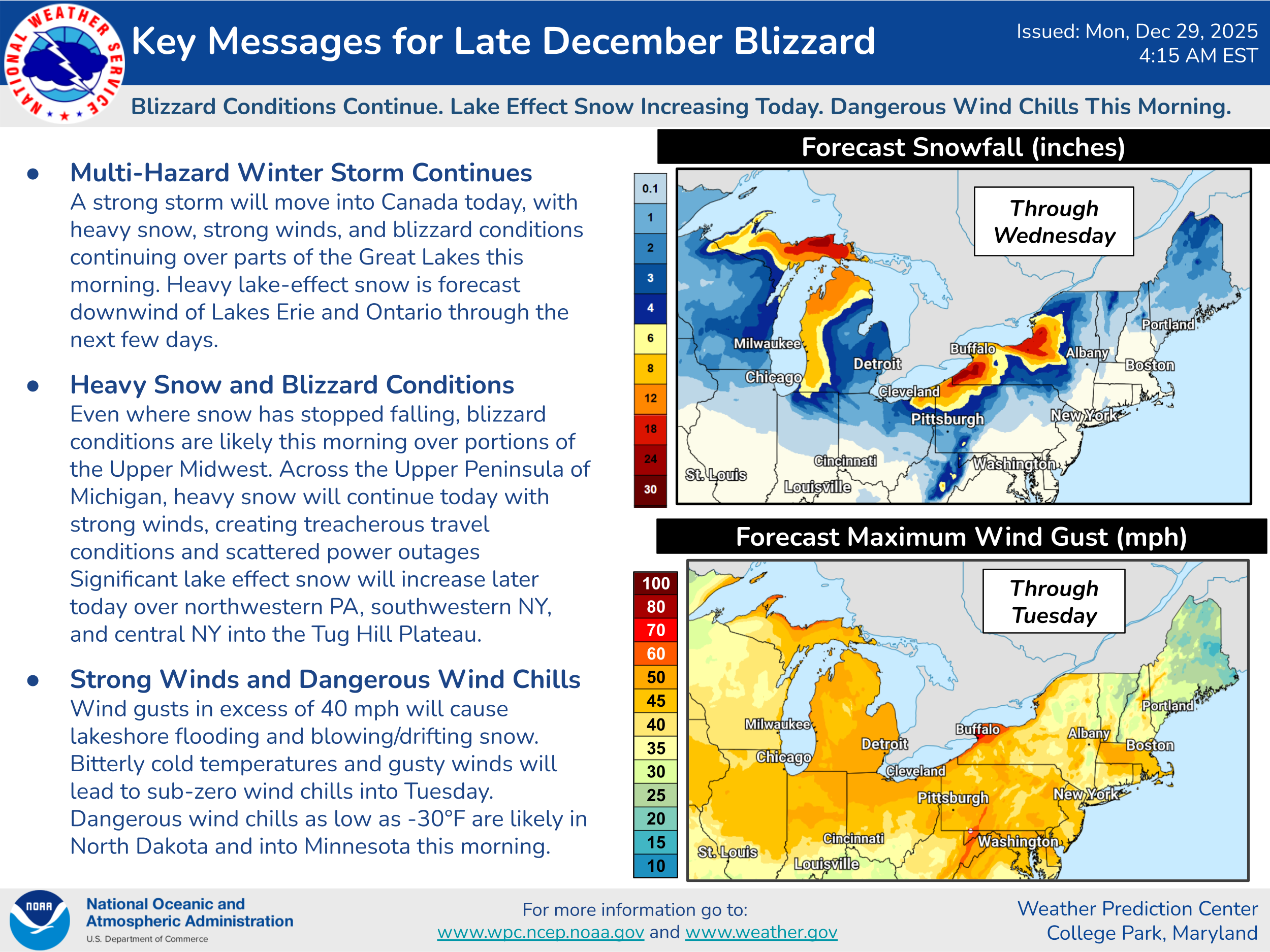
For today into Tuesday, the intense low pressure system will continue to produce strong winds in the Great Lakes and Northeast region and heavy lake effect snow downwind of the lakes. As noted in the NWS Weather Prediction Center key messages above, even where snow has stopped falling, strong winds in areas with recent snowfall will cause dangerous travel with blowing and drifting snow.
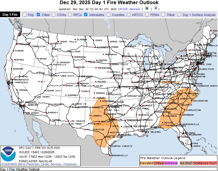
Strong winds and dry air will also cause increased wildfire danger in parts of the Southern Plains and Southeast where drought conditions are also ongoing. I will be talking more about the drought situation across the country in tomorrow’s post.

Leave a comment