Record warmth continues ahead of strong low pressure system in the Midwest, with a growing concern for flash flooding across parts of the South Friday into Friday night
Jan 08, 2026
Today is another one of those days where there is so much going on with regard to weather and climate that I truly do not know where to start, e.g., the US withdrawing from the Intergovernmental Panel on Climate Change, extreme record warmth occurring in multiple parts of the planet including Australia and northern Africa across eastern Europe and western Asia, and Storm Goretti causing major winter weather and wind impacts in the UK and northern Europe. We have impact weather occurring in the US today, though, so I will start there. I will hopefully have time later to cover some of these other topics in more detail, but in the meantime I encourage you to click on the links to read about them.
I talked yesterday about the marginal risk of severe weather across the Southern Plains over the upcoming 36 hours, and early this morning a line of severe thunderstorms developed across central Oklahoma just west of Interstate 35 (radar loop above courtesy NSSL’s Multi-radar Multi-sensor System). This line is being driven by strong atmospheric forcing from an intensifying low pressure system combining with unusually warm and humid air — surface temperatures and dewpoints were in the lower to middle 60s across central Oklahoma ahead of the storms.
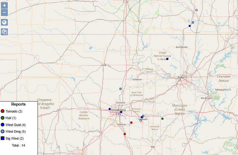
This band of storms produced a number of incidences of severe weather as it moved across the eastern half of Oklahoma and southeast Kansas, including at least two radar confirmed tornadoes southeast of Oklahoma City, wind damage to businesses in Shawnee, and a measured 88 mph wind gust at the Oklahoma Mesonet site at Wynona.

Images of rather significant damage to homes and buildings from the tornado near Purcell, OK have been posted by local media. Needless to say, severe weather in Oklahoma in January is rather unusual, although as recently as 2023 a severe weather episode brought a record 5 tornadoes to the state on January 2nd.
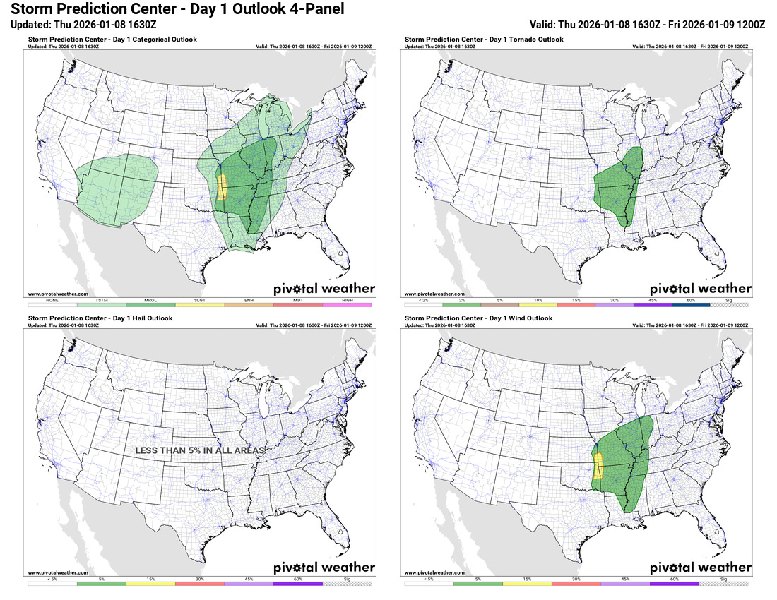
As the strong low pressure system currently over Kansas continues to intensify and lift northeast into Iowa, the risk of severe weather will continue downstream across the Midwest and Mid-South. The Storm Prediction Center currently has a large marginal (level 1 of 5) risk of severe weather for damaging winds and possible tornadoes across this region.
However, it is important to recognize that these types of winter severe weather situations with strong atmospheric dynamics combined with potentially just enough unstable air are particularly challenging forecast and warning situations. These strongly forced bands of low topped thunderstorms can evolve very rapidly, and go through periods of greater organization and production of severe weather like we saw in central and eastern Oklahoma this morning.
Of particular note is that some of the AI severe weather forecasts (NCAR AI probabilities based on the European ensemble above) and morning high resolution models show the possibility of a greater, more organized risk of severe storms as the activity moves toward eastern Missouri and Illinois later today and into this evening.
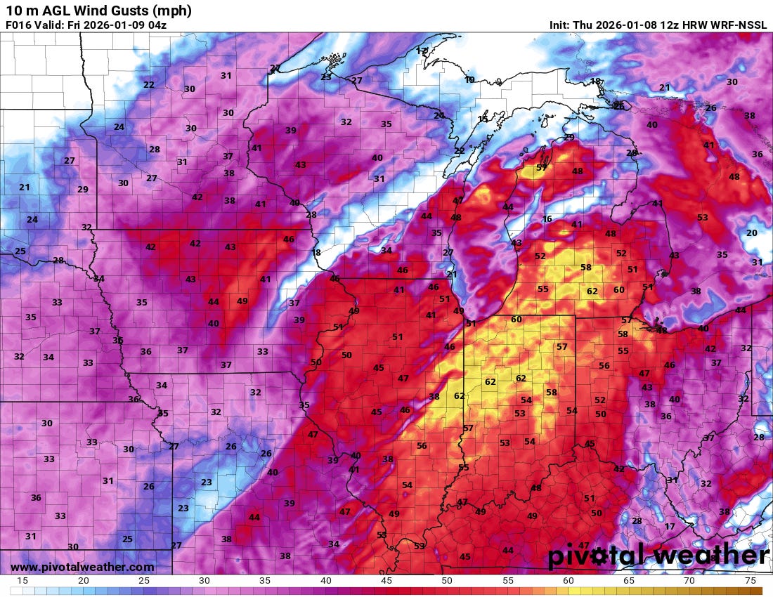
Some of the high resolution models (NSSL WRF above) show showers and thunderstorms continuing to produce strong wind gusts as the activity moves into the lower Great Lakes tonight while the storm system continues to intensify. While this is a lower probability outcome right now, this is the type of setup where if a more organized band of showers and storms persists widespread damaging winds could occur, so it will be worth watching the evolution of things into tonight.
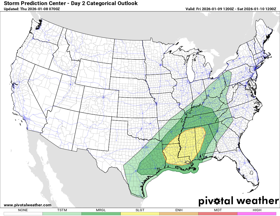
The threat of severe weather will continue on Friday across the lower Mississippi Valley, although this risk seems to have diminished somewhat compared to earlier forecasts — as the atmosphere has trended stronger with today’s low pressure system and associated severe weather risk, tomorrow’s has decreased somewhat. Still, a few severe thunderstorms with damaging winds and tornadoes appear possible with the Storm Prediction Center having a slight (level 2 of 5) risk (shown above).

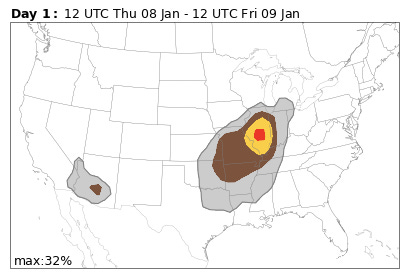
While the risk of severe weather appears to have decreased somewhat for Friday, the risk of flash flooding looks to be increasing across the lower Mississippi and Tennessee Valleys for Friday into early Saturday. The cold front associated with the upper Midwest storm system will be slowing significantly as it reaches this region. Upper level disturbances moving along the front will combine with unusually high levels of moisture to produce waves of showers and thunderstorms with heavy rainfall. The high levels of moisture will support unusual rainfall rates for this time of year, which when combined with the hard ground and lack of vegetation in mid-winter could result in some incidences of significant flash flooding. The Weather Prediction Center has a large slight (level 2 of 4, shown above) risk in this area for Friday into Friday night — but in their morning discussion indicated that an upgrade to a moderate risk is possible in later forecasts.
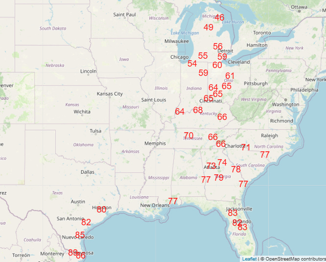
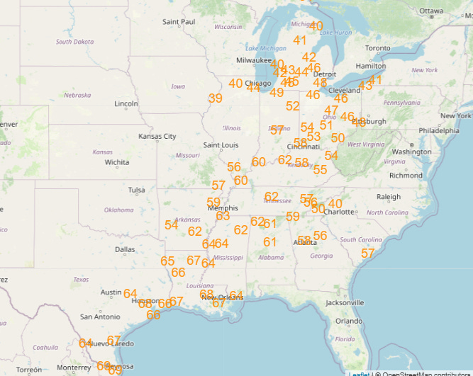
Widespread record warmth will continue on the south and east side of this storm system, with numerous record highs (top graphic) and record warm minimums (bottom graphic) forecast on Friday.
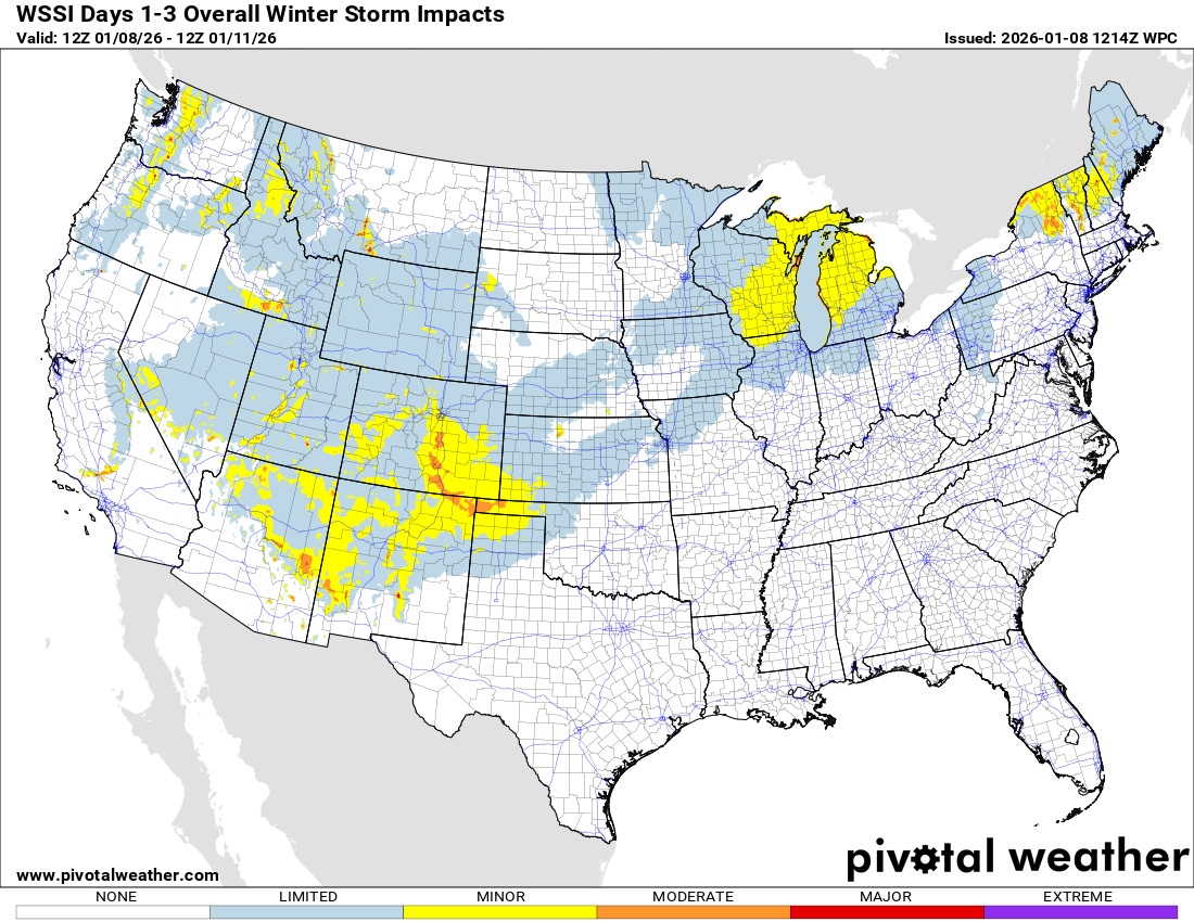
On the cold side of the storm system, some moderate to heavy snow will fall over the next 48 hours in parts of Southern Rockies and the Texas and Oklahoma Panhandles. Snow and some wintry mix is also expected over parts of the upper Midwest and Great Lakes and eventually higher elevations of the Northeast by this weekend.

Leave a comment