Near record warm Gulf waters feeding unusual moisture and warmth ahead of slow moving storm system, which will also yield potential for significant flash flooding and some severe weather in the South.
Jan 09, 2026
Happy Friday! Lots to talk about in weather today, so let’s get to it.
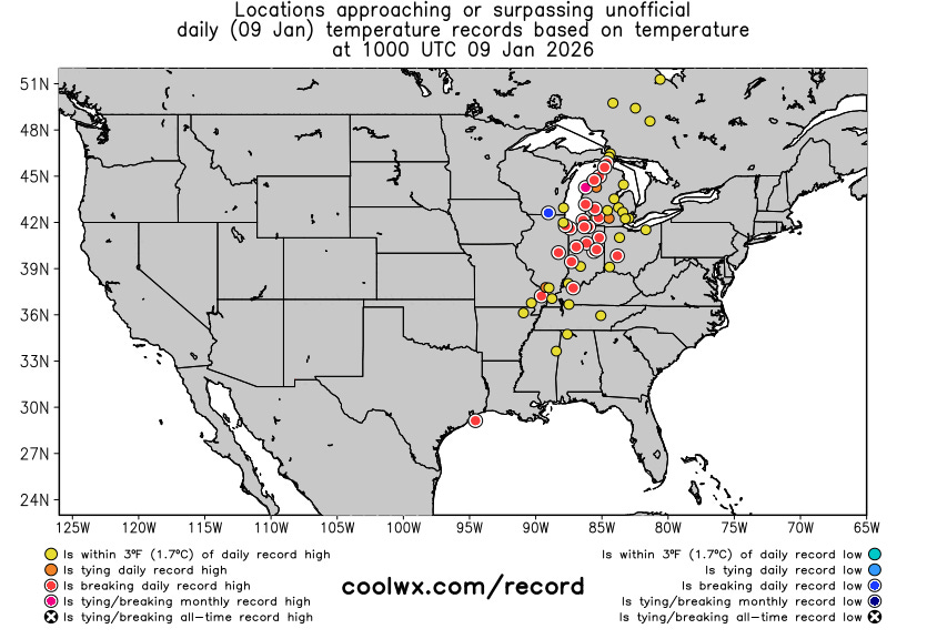
I posted a note late last evening about the NBA game between the Chicago Bulls and the Miami Heat in Chicago being postponed because of moisture on the floor. The moisture was there due to condensation that resulted the unusual warmth and humidity in northern Illinois after a hockey game in the arena the night before. I highlighted that parts of the Midwest were seeing record high temperatures at 10-11 pm — and that trend continued into the early morning hours. The graphic above shows the locations that were at or near record high temperature levels at 4 am CT this morning (the blue record low is a bad ob).
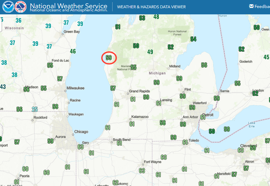
Numerous locations in the Great Lakes region set daily record high temperatures during the early morning hours today. The NWS automated observation site at Ludington, MI (circled) recorded a preliminary high temperature of 59F at 3:15 am CT. If this max temperature is confirmed at the nearby NWS co-operative climatic site, it would be an all-time monthly record high temperature for January, surpassing a record of 58F set on January 27, 1916. Regardless of if the official monthly record is set, it is truly amazing to see temperatures near all-time monthly record highs in the pre-dawn hours.
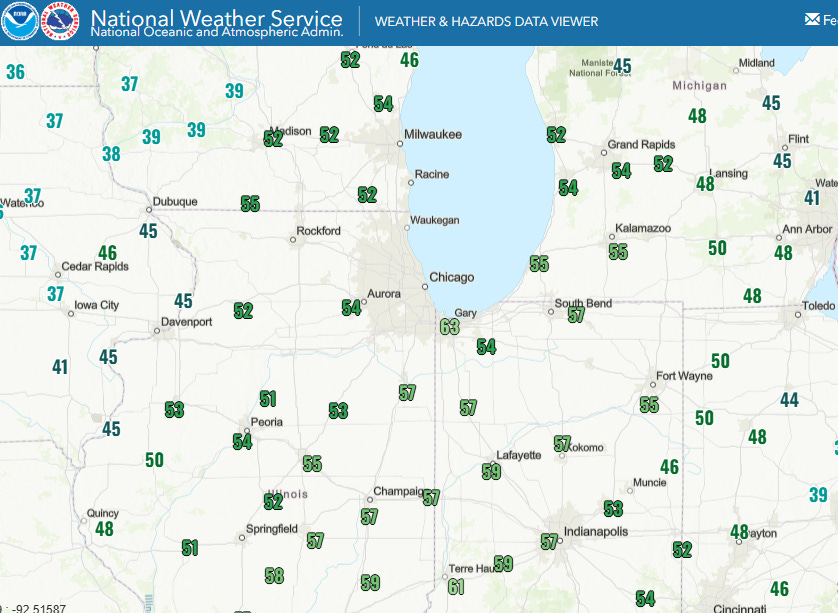
The temperatures being so warm overnight is a combination of the warmth but also the unusual levels of moisture, as seen in the condensation that forced the NBA postponement. Dewpoint values at midnight CT (above) were incredibly high for early January, in the 50s and even lower 60s in spots across this region as southerly winds ahead of an intensifying system moving northeast through the Great Lakes region pulled Gulf moisture north.
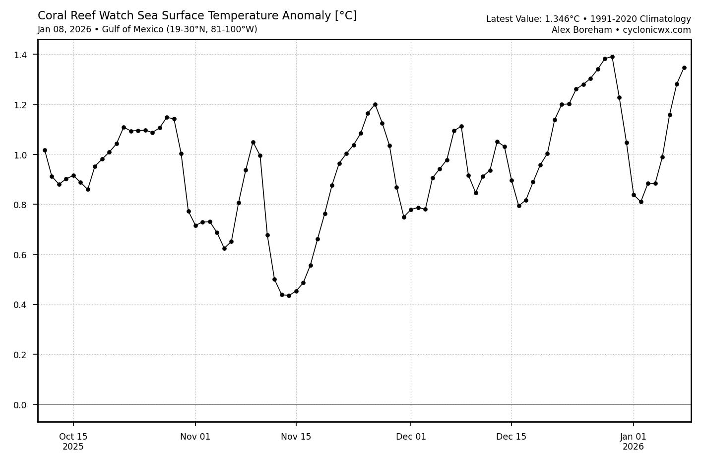
That Gulf moisture is being amped up by unusually warm Gulf of Mexico sea surface temperatures (SSTs) that have been running near record warm levels for this time of year — the warmer the SSTs and atmosphere, the higher the moisture content of the atmosphere. So as global warming continues, two very clear impacts on our climate are higher levels of atmospheric moisture and warmer overnight low temperatures.
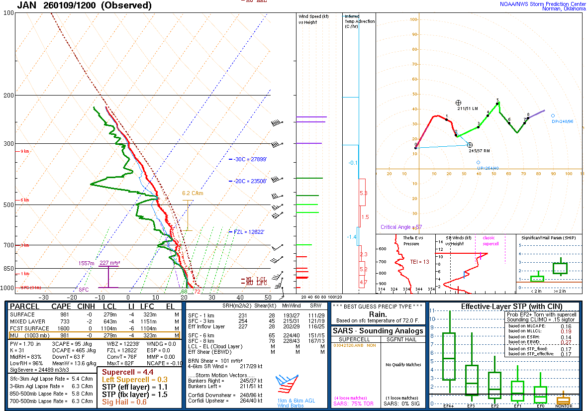
Obviously, increased levels of moisture can produced increased rainfall rates. This morning’s upper air balloon data from Jackson, MS (above) showed a precipitable water (PW, (the depth of water that would result from all of the moisture in the atmosphere being condensed as rain) value of 1.70.” Looking at the upper air climate record from the Storm Prediction Center, this appears to be a daily record at the site and is certainly near the top of PW values ever observed in January here.
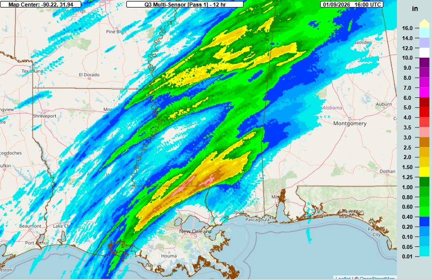
This moisture has already been feeding showers and thunderstorms with heavy rainfall in the Lower Mississippi and Tennessee Valley regions, particularly over parts of southern Mississippi and eastern Louisiana where a band of 2-4” has fallen over the last 12 hours.
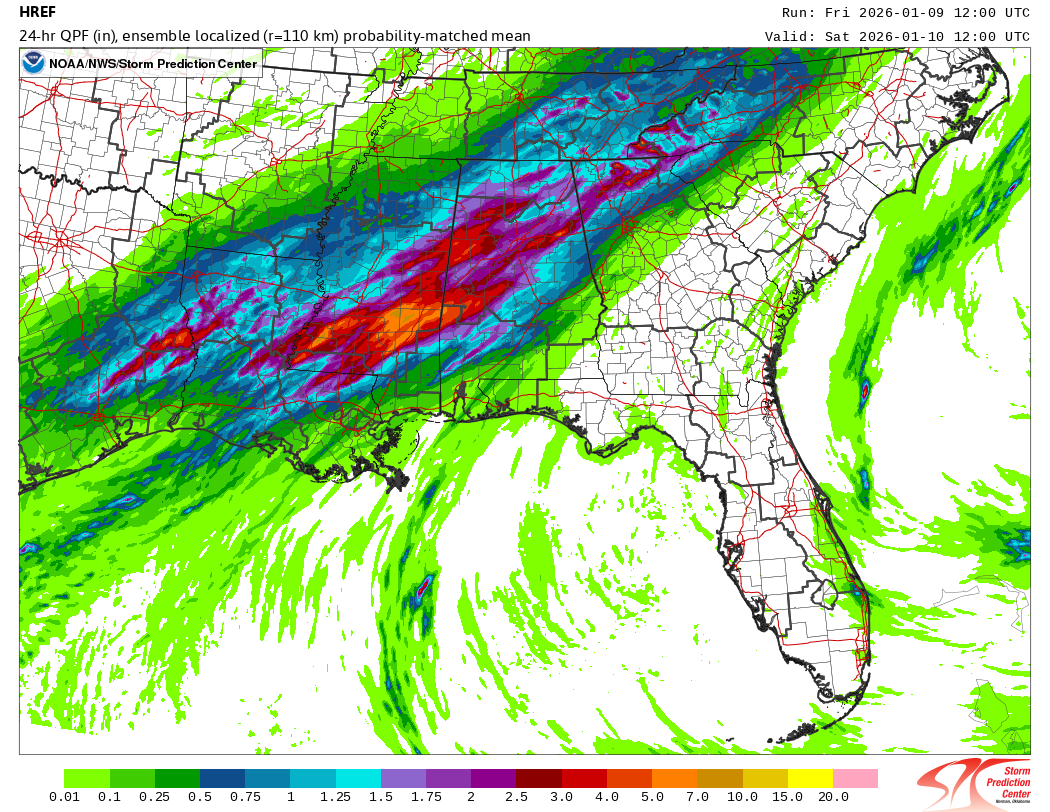
Additional disturbances moving along a slow moving cold front will trigger additional waves of showers and thunderstorms with heavy rainfall across this region through tonight, with the morning high resolution ensemble models suggesting areas of 4-7” of rain possible across southern Mississippi and western Alabama on top of rain that has already occurred.
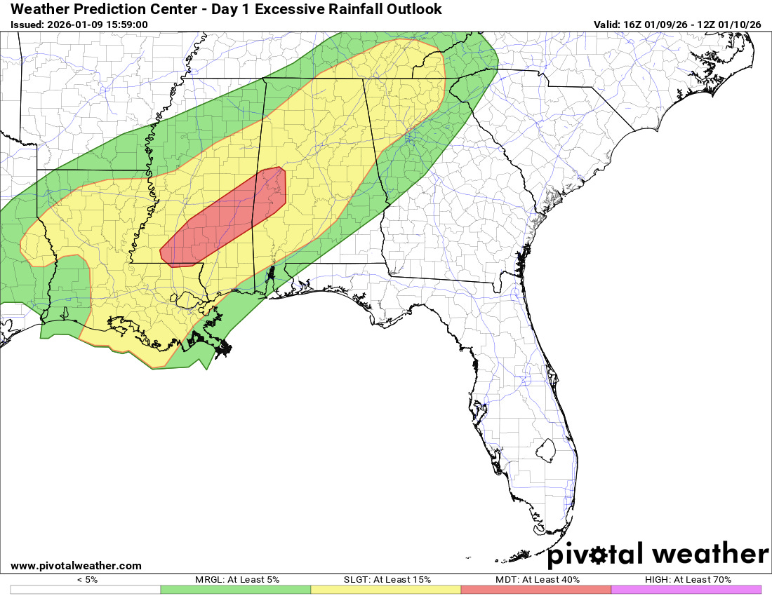
As a result, the Weather Prediction Center has issued a moderate (level 3 of 4) risk of flash flooding for this area through tonight. Thunderstorms with high rainfall rates are a particular concern for flash flooding at this time of year as the lack of active vegetation means that the ground can absorb less rainfall, meaning more runoff and quicker flooding. Hence, the unusually high moisture levels combined with the slow moving front and multiple rounds of storms yield a concern for some instances of significant flash flooding in this area.
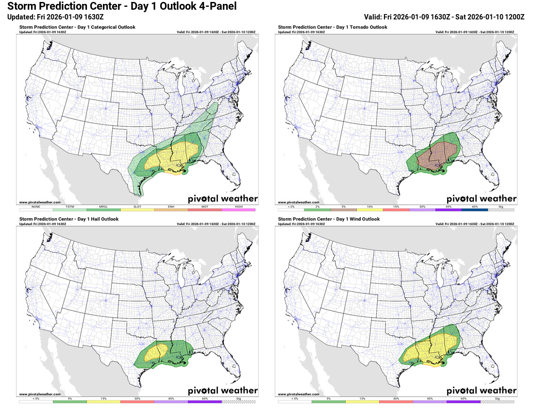
There will also be a risk of severe thunderstorms across this region this afternoon and tonight. Early morning severe storms already produced a few tornadoes in parts of central and southern Mississippi, and as the next upper level weather disturbance approaches from the west, the risk of severe storms should increase across far eastern Texas and northern Louisiana later this afternoon. The threat should then shift across Mississippi and into western Alabama tonight. Damaging winds and a few tornadoes look to be the biggest risks with these storms, although some hail is also possible especially across eastern Texas and western Louisiana.

Bands of strong to severe storms ended up causing additional reports of wind damage across Illinois last night. The NWS in Norman confirmed four tornadoes across central Oklahoma from the early morning severe storms across central Oklahoma, including a nearly 10 mile long high end EF-1 tornado that damaged several homes and buildings near Purcell, south of Oklahoma City.
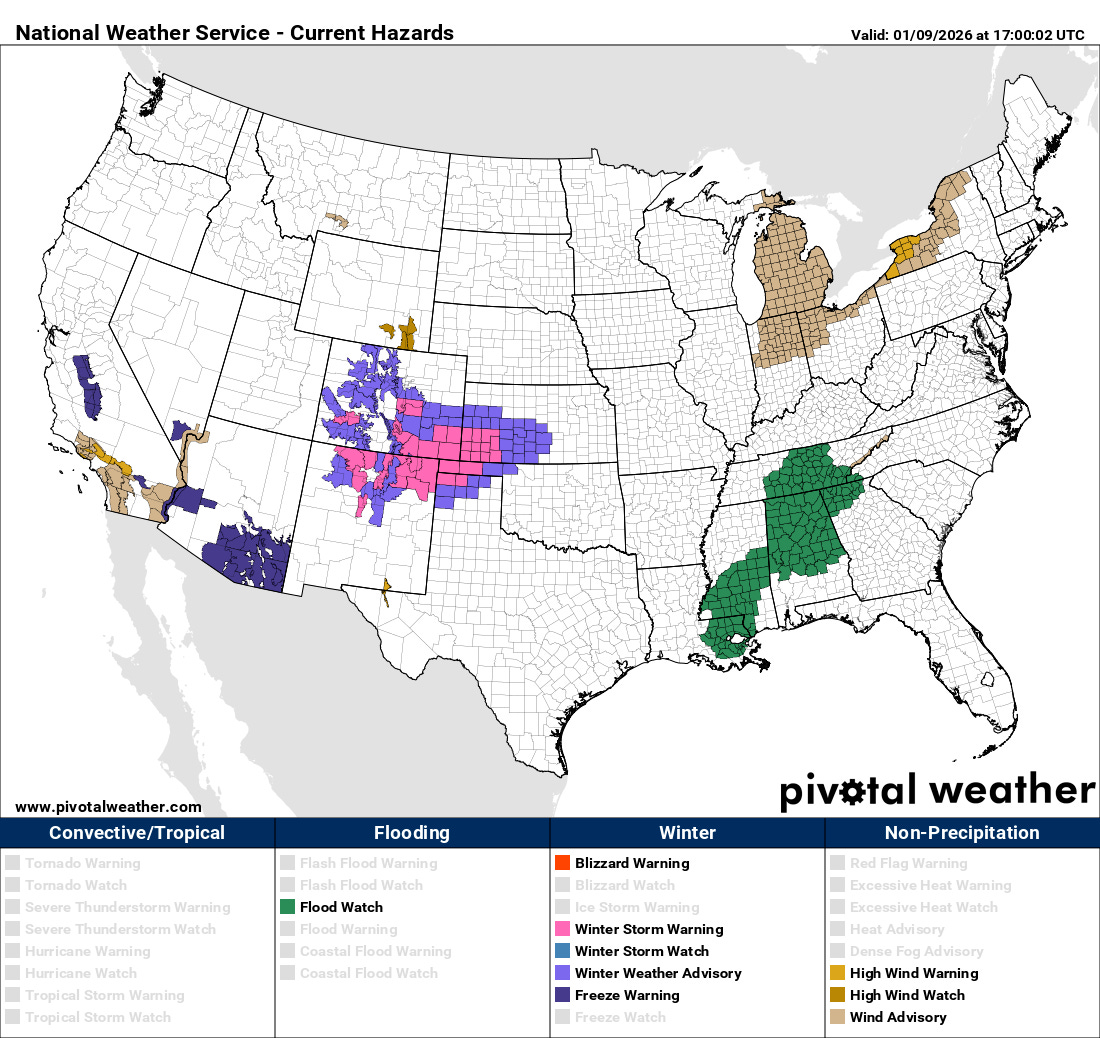
On the cold side of this storm system, moderate to heavy snow is expected over the next 24 hours across parts of the Rockies and Plains, and winter storm warnings and advisories are in effect. Colder air filtering in behind the system has resulted in the issuance of freeze warnings for parts of California and Arizona. As of now, though, no record cold temperatures are forecast.
While there is obviously a lot going on in US weather, I want to finish by highlighting the extreme heat and wildfires ongoing in parts of Australia. Three people are missing and more than 30 wildfires are ongoing in the state of Victoria. Melbourne reached 43.4C (110F) Friday (Australian time), with the maximum temperature observed in the region being 46.3C (115F) at Hopetoun. A cold front will be moving across the region overnight, bringing some break to the heat for the weekend.

Leave a comment