Big upper level high pressure area along west coast means changes nationwide. Also, recapping the heavy rain and severe weather in the South.
Jan 10, 2026
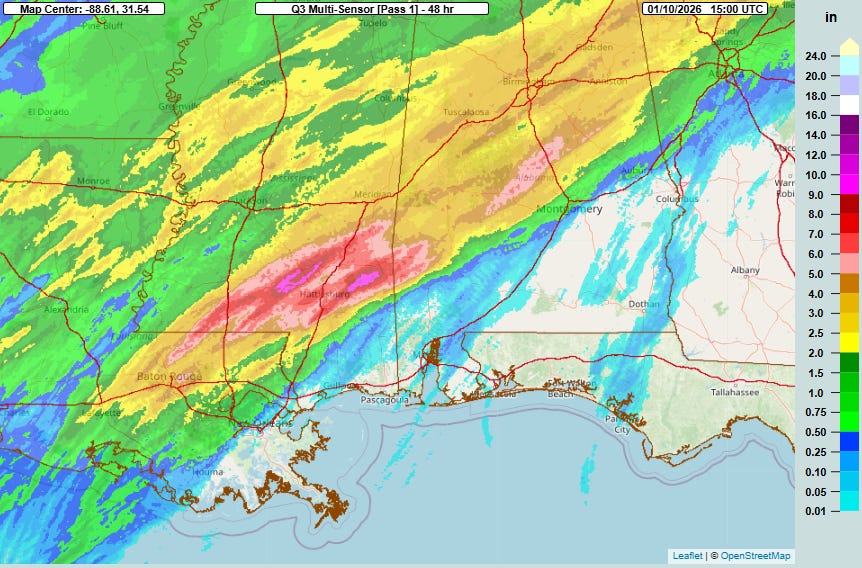
Late this morning, a band of thunderstorms were pushing east near the Alabama/Georgia state line, the final act in a heavy rain and severe weather episode for the Deep South over the last 36 hours. Fed by record levels of moisture for this time of year, total rainfall was very impressive for an early January event in this region, with multiple bands of 5+” of rain across eastern Louisiana, southern Mississippi, and Alabama. The heaviest rainfall was over the Pine Belt region of southeast Mississippi, where 10.69” of rain in 36 hours was measured at the RAWS site at Wausau, MS, northeast of Hattiesburg. I had discussed yesterday the potential for some significant flash flooding, but luckily the heaviest rainfall fell in rural areas which helped limit flash flooding, and river levels were particularly low going into this event due to ongoing drought in the region which minimized river flooding.
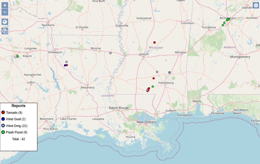
The most impactful flooding actually occurred outside of the heaviest rainfall totals, as a wave of heavier rainfall during evening rush hour resulted in urban flooding and water rescues in Birmingham last night. Severe storms also resulted in some sporadic reports of wind damage and a few tornadoes across the region, and as the band of storms I discussed above moved across eastern Alabama and into far western Georgia this morning it produced a number of reports of downed trees and powerlines. Approximately 50K customers are without power this morning in this area per PowerOutage.us.
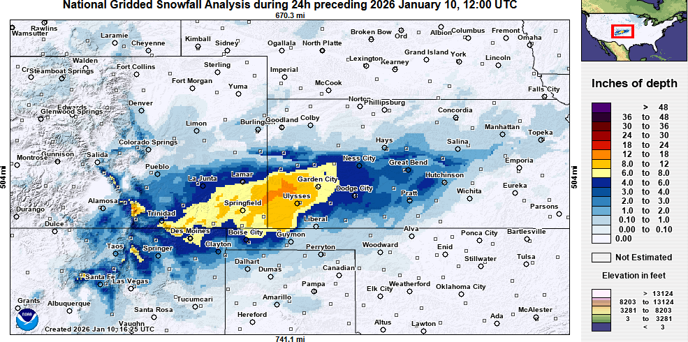
On the cold side of the system, moderate to heavy snow fell across parts of the Southern Rockies and adjacent Plains, with the heaviest snow focused over southwest Kansas where localized areas west of Garden City picked up as much as 18” of snow.

Overall, the weather will be trending quieter this weekend. A few severe thunderstorms and incidences of flash flooding will remain possible in parts of the Southeast into early afternoon with the aforementioned band of thunderstorms, but overall the trend for this activity should be gradually decreasing. Farther north, some mixed wintry precipitation is expected in parts of the Northeast with some heavier lake effect snow possible in the upper Great Lakes. Winter weather advisories are in effect for eastern Wisconsin and much of the UP and northern LP of Michigan, as well as Maine and higher elevations of northern New England.
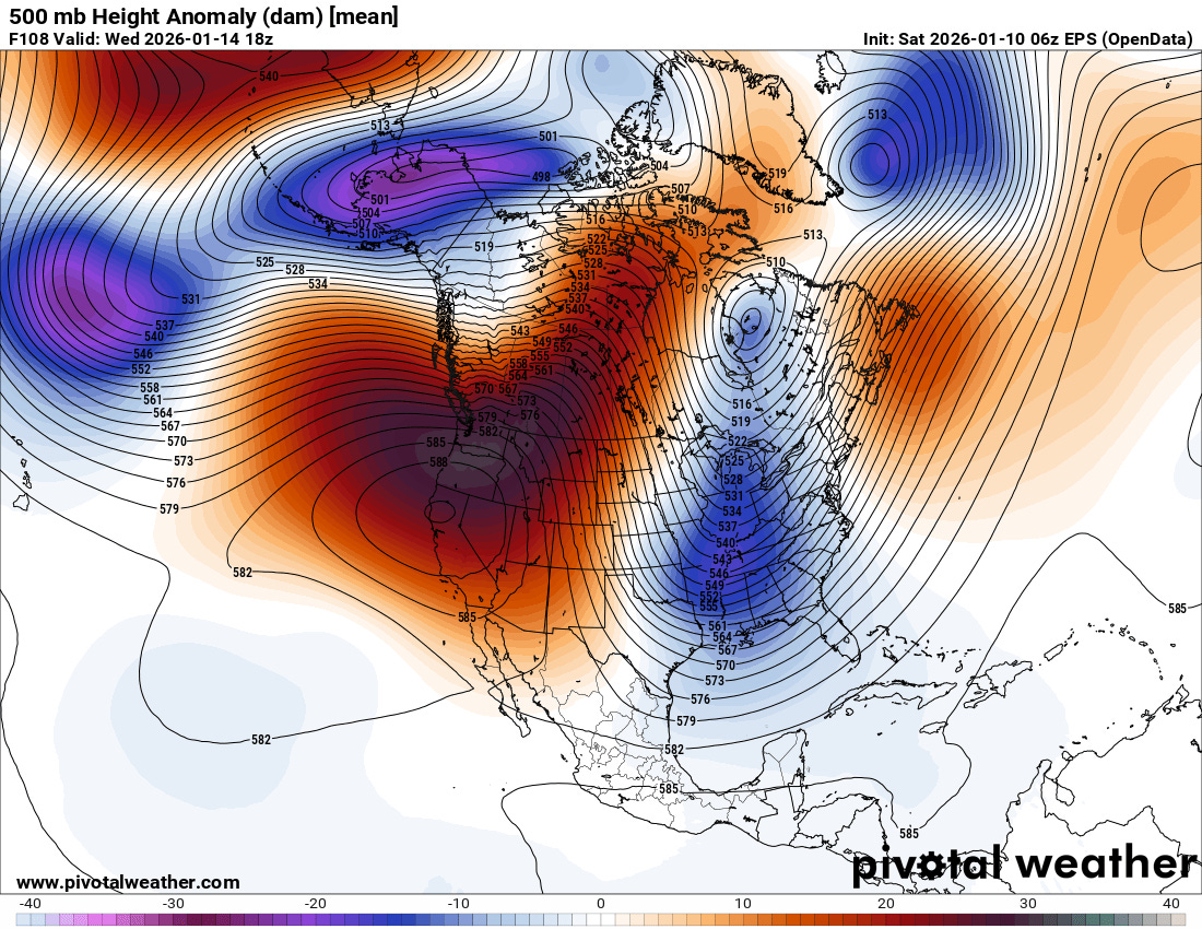
As we head into next week, a significant shift in the weather pattern is anticipated, as show in the 500 millibar (18,000 ft above ground level) forecast chart from the European ensemble for midweek. An unusually intense area of middle and upper level high pressure will build across the western United States and eastern Pacific, with a downstream trough of low pressure across the East.
This pattern will be reminiscent of what we saw in early December, with widespread above normal and at times record warmth in the West — except the San Joaquin Valley which will likely see prolonged fog and cooler weather. Meanwhile, the East will be colder than normal, with an increased probability of some impactful winter weather which we will be keeping an eye out for.

Leave a comment