US and globe have seen a lot of warmth, but there are pockets of cold. Dryness continues to be a concern for many parts of the US as well.
Jan 11, 2026
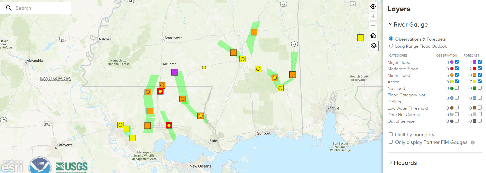
Starting off this morning with a quick addendum to yesterday’s post about the very heavy rainfall in parts of southern Mississippi and eastern Louisiana. While as expected the river flooding did not end up being a huge impact in spite of the rather widespread 5-10” of rain across the region due to the prolonged dry weather leading into the event, the Tangipahoa River is now forecast to go into moderate flood and the Bogue Chitto River has reached major flood stage at Tylertown, MS. Given the dry weather and low river levels going into this rainfall event, this is quite impressive and further emphasizes the magnitude of this rainfall event.
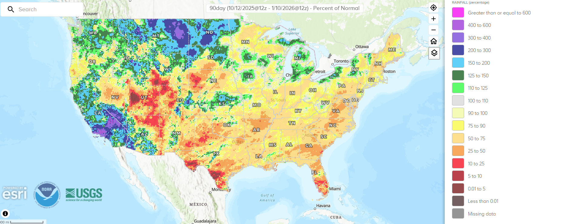
Taking an updated look at how the nation is faring as far as precipitation, the NWS percentage of normal precipitation over the last 90 days (through yesterday morning, above) shows that most of the country has been abnormally dry. Parts of the central and southern Intermountain West, the Southern Plains and Texas, and Florida have been especially dry.
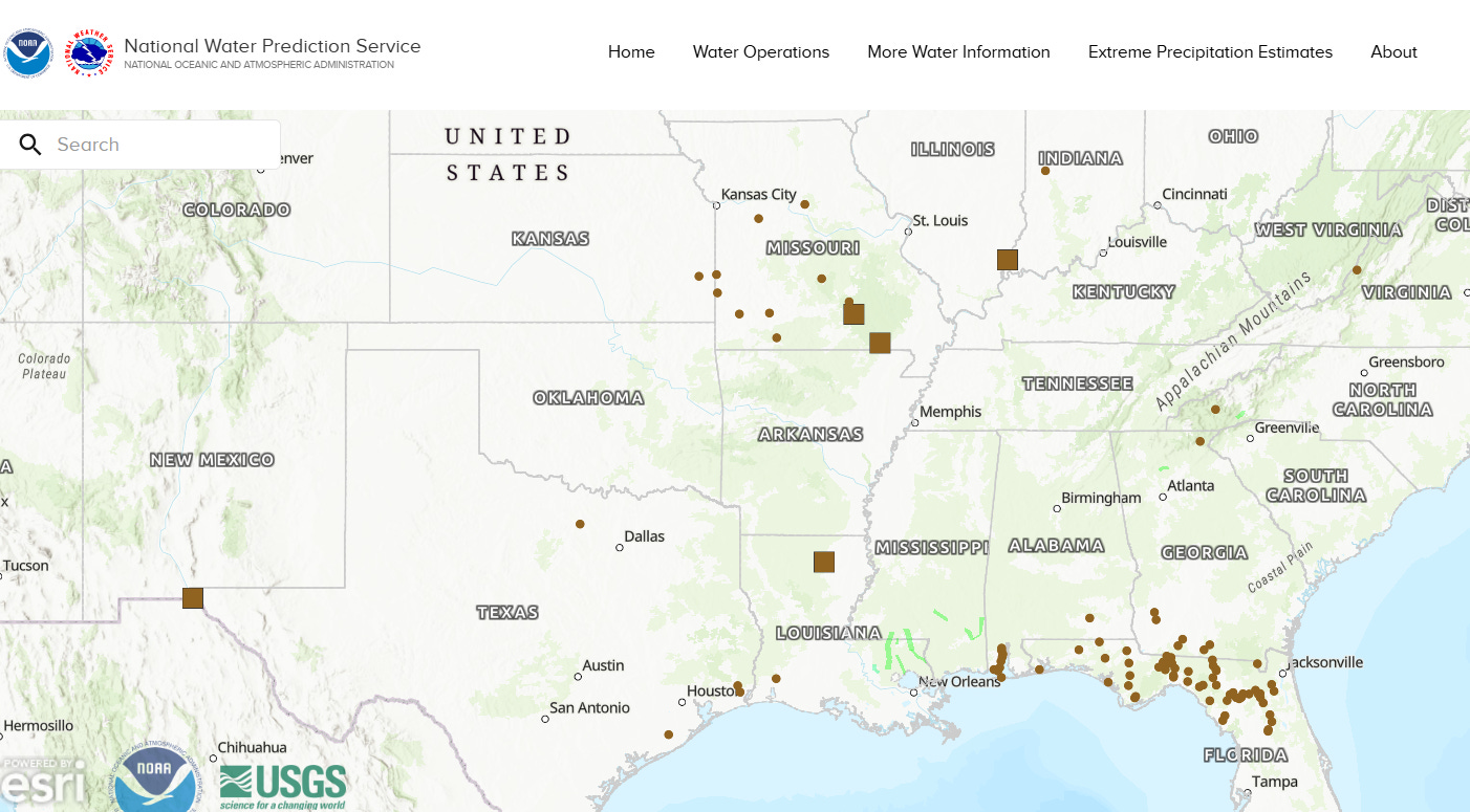
This is also reflected in streamflow data, as a number of locations around the central and southern part of the country are seeing locations below low water threshold. This is particularly the case in northern Florida and adjacent areas.
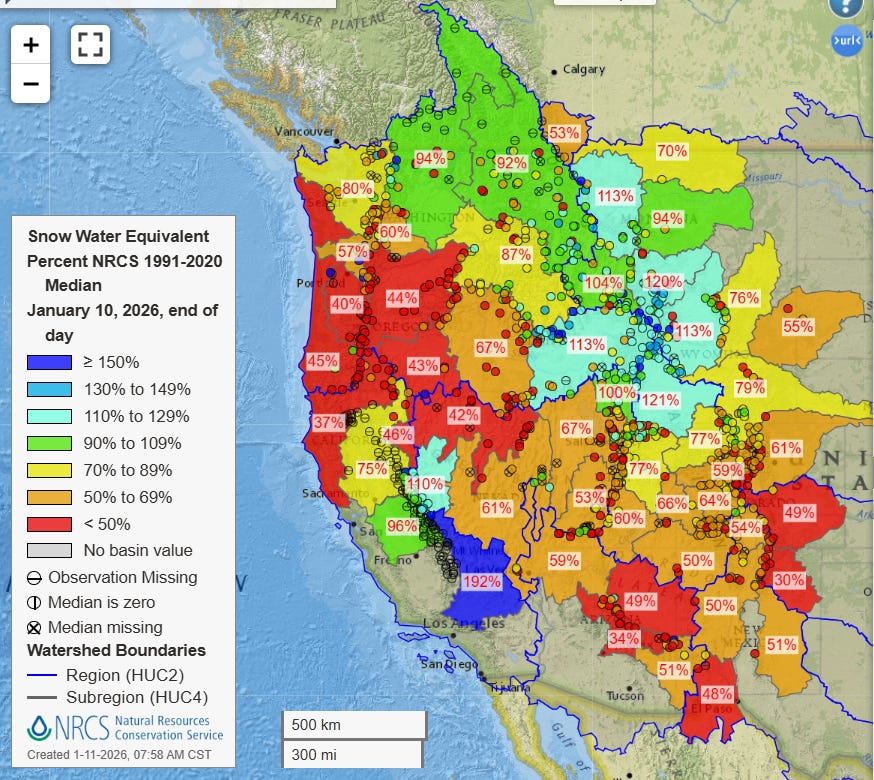
It is also reflected in the snowpack data, which shows below to much below normal snowpack for much of the central and southern Rockies. Conversely, the northern Intermountain West into the Cascades has near to somewhat above normal snowpack, reflective of the significantly above normal precipitation in this region.
The snowpack is even more of a mixed bag farther west closer to the coast. The central and southern Sierra is well above normal as the atmospheric river storms of late December eventually had sufficient cold air to lower snow levels and result in very heavy snowfall. Farther north, though, somewhat less precipitation combined with warmer conditions when precipitation fell has led to much below normal snowpack for much of northern California and Oregon, as well as into the Great Basin.
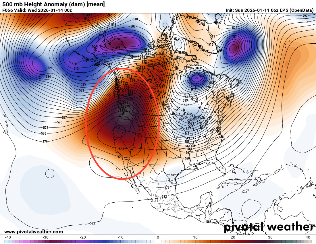
An unusually intense middle and upper level area of high pressure still looks on track to develop along the West Coast and eastern Pacific over the next few days, and this will likely be the dominant weather feature for North America for the next 10 to 14 days. This means above normal temperatures for much of the West (except for areas like the San Joaquin Valley where low clouds and fog will keep temperatures colder) as well as generally dry weather. This should mean the snowpack will be eroding over the next couple of weeks for much of this region.
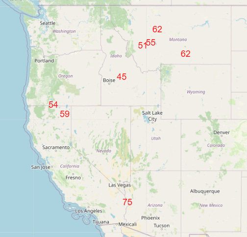
It will also mean some record warm temperatures at times for some locations (NWS forecast record high temperatures for Wednesday shown above).
A number of record high temperatures were set in the Southeast on Saturday ahead of the storm system we have been tracking the last several days. This included Norfolk (75F, previous record 72F), Cape Hatteras (73F, previous record 70F), Pensacola (80F, previous record 79F), and Savannah (82F, previous record 81F).
Record warmth has been dominating the US temperature pattern of the last month. Per the NOAA National Centers for Environmental Information (NCEI), the US has seen 7631 record max temperatures and 6905 record warm minimum temperatures in the last 30 days compared to 524 record low max temperatures and 452 record low minimum temperatures. I was talking at the end of December about the incredible number of monthly record warm temperatures being set at the end of that month, and the NCEI numbers bear that out as well: the last month has seen 421 monthly record highs and 555 monthly record warm minimums compared to 6 monthly record low maxes and 4 record low mins.
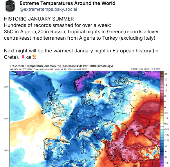
Globally, record warmth has been prevalent as well — along with the heat I have been discussing in Australia, areas of eastern Europe, northern Africa, and central Asia have seen all-time January warmth over the last several days. This has included extremely warm minimum temperatures above 20C in locations like Greece as discussed in the post by Extreme Temperatures Around the World above.
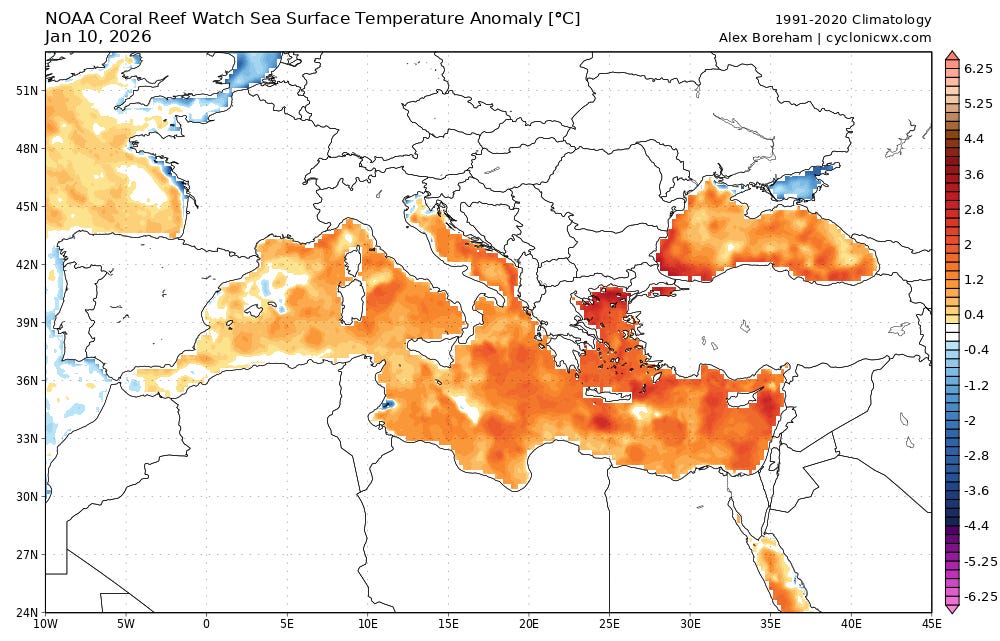
Like the Gulf of Mexico, the Mediterranean Sea is also seeing well above normal sea surface temperatures, which contributes more moisture to the atmosphere and leads to warmer morning low temperatures.

Warmer oceanic temperatures is obviously a global trend related to climate change. 2025 saw the warmest oceans on record based on the heat content of the upper 2000m of the ocean, continuing a warming trend that has been particularly prevalent since 2000.
Of course we still have plenty of cold, winter weather ongoing. As can be seen in that European temperature anomaly map above, much of western Europe and Scandinavia has been experiencing colder than normal weather this past week, and an intense winter storm earlier in the week snarled transportation and killed at least 6 people.
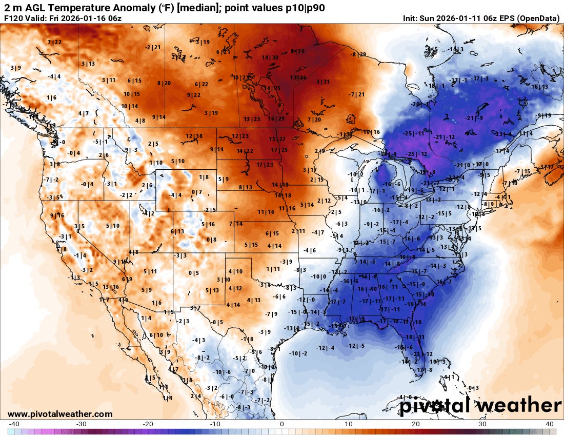
Downstream of the upper level area of high pressure along the West Coast, colder than normal weather will return to the East this week, with much below normal temperatures expected from eastern Canada to Florida by this Friday (forecast temperature anomaly from the European ensemble above) along with an increased risk for some wintry precipitation in parts of the region.
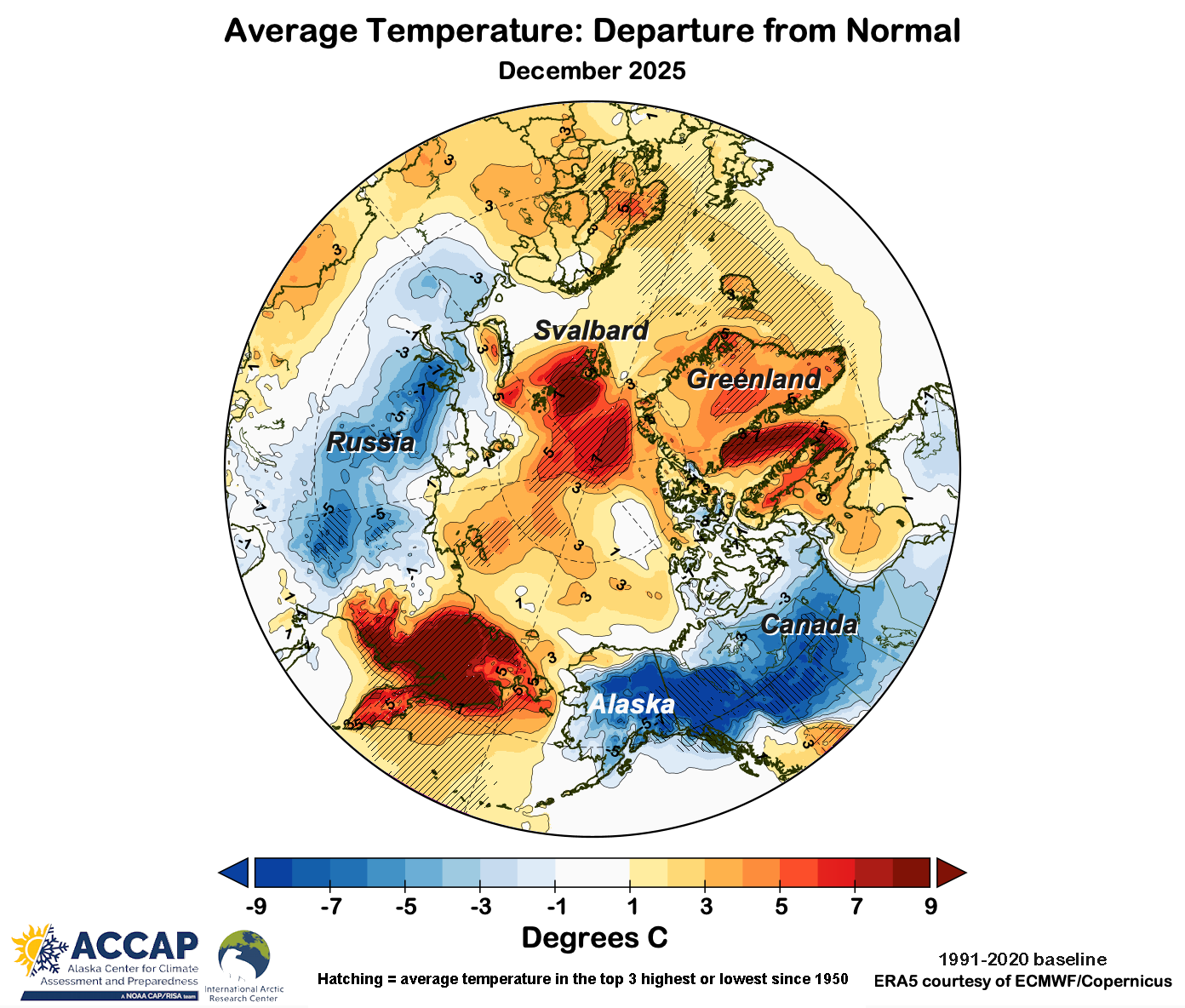
Alaska and Northwest Canada have also been seeing much below normal temperatures this winter along with above normal (and in some cases record) snowfall in many locations. My colleague Rick Thoman has an excellent summary of December 2025 weather in the Arctic on his Substack (graphic above from his article), as well as a great writeup of the extreme snowfall that southeast Alaska saw at the end of December.
This is one of the important aspects of climate change impacts that needs reinforcement: we will still see extreme winter weather in a climate impacted by global warming. However, we are tipping the scales toward warmer temperatures being seen more frequently, and that can clearly be seen in the data. The overwhelming number of record warm temperatures compared to record cold that we have seen in the last 30 days is not a blip or anomaly, it continues a trend that has been building for years. We can anticipate that it will continue to trend that way for the foreseeable future.

Leave a comment