Model trends suggest a shift north in greater ice accumulations for Mid-Atlantic and Ohio Valley, while serious ice storm also still looks on tap for the Mid-South.
Jan 24, 2026
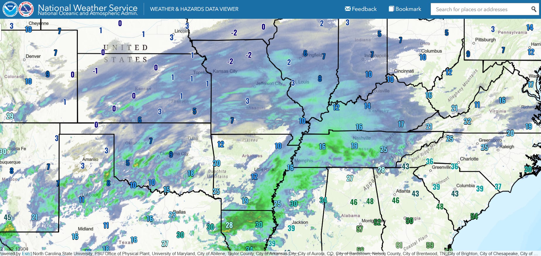
Good afternoon, apologies for the lateness of this post but there is a LOT to talk about. The advertised major winter storm is now in full swing across the central part of the country. This display of temperatures and radar shows extremely cold temperatures in the single digits have overspread much of the Midwest and Southern Plains, with 30F and colder temperatures as far south as northern Louisiana and the Mississippi Delta. Snow is falling across much of the Plains and Midwest, while mixed sleet and freezing rain is causing icy conditions across the Mid-South as well as parts of northern Texas.
Moderate to heavy snowfall had already accumulated as of 6 am CT this morning across much of Oklahoma and Kansas across northern and central Arkansas into western Tennessee. 6-10” had fallen in higher elevations of northern Arkansas, with 6” also reported in northern parts of the Little Rock metro area.
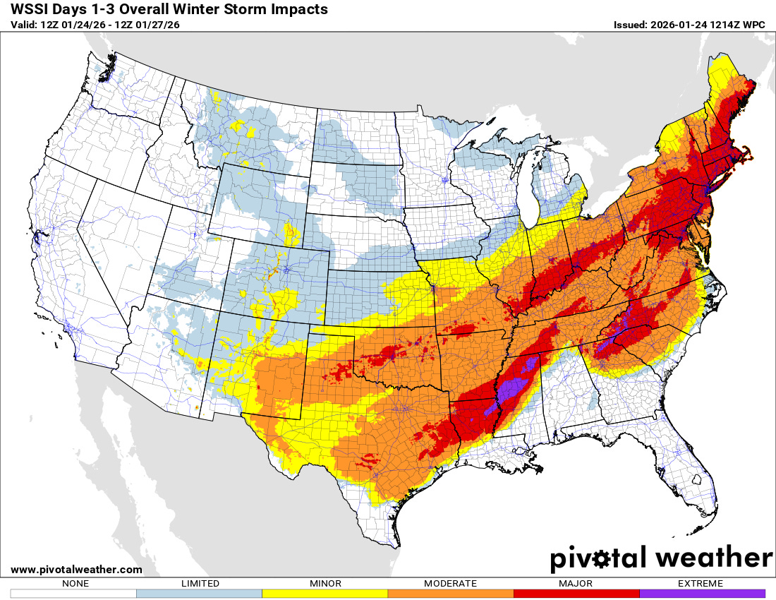
At a high level, the overall forecast with this system generally looks on track with widespread moderate to major impacts through Monday across a large swath of the country from Texas to the Northeast as shown by the NWS Weather Prediction Center (WPC) Winter Storm Severity Index (WSSI). However, there has been some noticeable evolution in the details for several areas, and I want to go through the next few days in detail to describe some of those important changes.
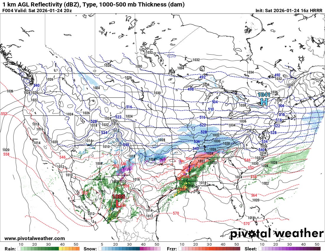
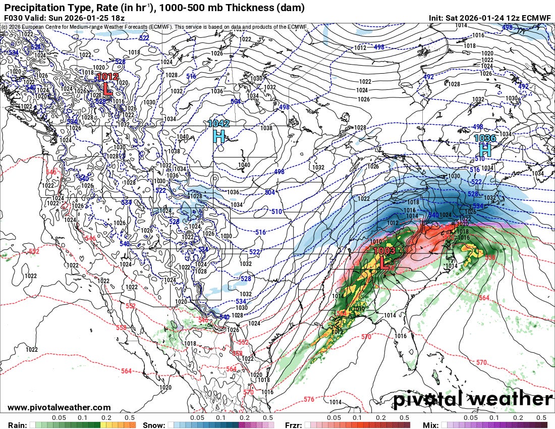
By mid to late afternoon (latest HRRR forecast of precipitation and sea level pressure for 2 pm CT above), widespread wintry precipitation will be pushing east across the Ohio Valley and Mid-South as low pressure develops along the western Gulf Coast. Meanwhile, a new wave of precipitation will be evolving from New Mexico into Oklahoma as the next weather disturbance moves into the region.
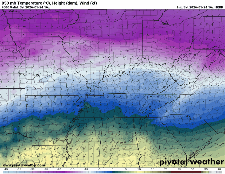
This animation of forecast temperatures and winds at 850 mb (about 5K ft AGL) shows a critical aspect of what is anticipated across the Mid-South, Tennessee Valley and Southeast the next 24 hours. As the low pressure system continues to organize along the western and central Gulf Coast, strong southerly winds will develop above the surface, bringing warm and very moist Gulf air north. This increasing warmth will gradually warm temperatures throughout the lower levels of the atmosphere, causing many areas that are currently seeing sleet and snow to change to freezing rain. This will also provide moisture that will fuel waves of heavy precipitation including some thunderstorms.
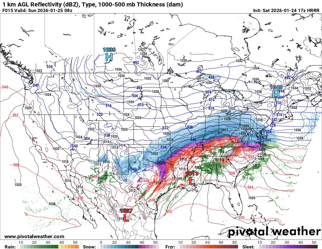
Hence, as we get into tonight (2 am CT forecast from latest HRRR above), freezing rain should be the more dominant precipitation type from the Arklatex northeast into much of Kentucky and Tennessee, with sleet and heavy snow farther to the northwest. By this time, the initial thump of heavy snow will be spreading into the Mid-Atlantic and upper Ohio Valley as well.
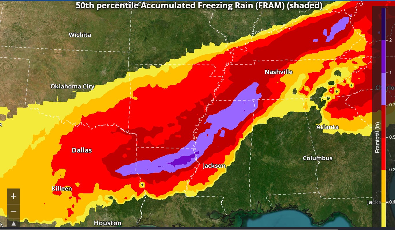
Widespread significant ice accumulation from freezing rain is thus expected from the Arklatex across the Arklamiss Delta and into parts of the Tennessee and Ohio Valleys. Particularly heavy ice accumulations of .5-1.5” look probable from parts of northeast Texas and northern Louisiana across northern Mississippi into parts of Tennessee and Kentucky. As we have been discussing, these sorts of glaze accumulations due to freezing rain would cause catastrophic damage to power infrastructure and trees along with resulting in nearly impossible travel. As I discussed in a note yesterday, the Atlanta metro area continues to be an area that is right on the edge. While currently in an ice storm warning, model trends continue to suggest a significant gradient in ice accumulation across the metro area, with the more impactful ice accumulations from the Athens area northeast where the “wedge” of cold air looks to be more pronounced.
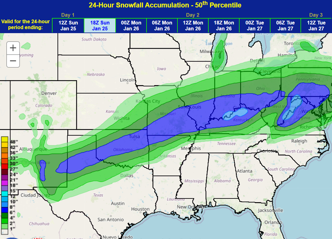
Farther north, heavy snow will be the predominant impact, with the WPC forecast of snowfall from now through midday Sunday above. Some heavy sleet will also occur within the southern edge of this depicted area of snow, which will exacerbate poor travel conditions.
As we go through the day Sunday, the low pressure system along the Gulf Coast will continue to intensify and lift northeast (forecast of pressure and precipitation from the recently arriving European model above, valid at 1 pm ET Sunday). I discussed yesterday how the anticipated “transition” of this surface low to a more coastal low would play a pivotal role in precipitation type across the Southeast and Mid-Atlantic. The most recent model trends suggest that the initial Gulf Coast surface low is going to be stronger and more persistent than earlier forecasts suggested — you can see in the map above the low along the North Carolina coast is just getting going early Sunday afternoon. This will mean more warm air just above the ground surging north — and hence a transition to freezing rain and sleet for the Mid-Atlantic on Sunday after the initial wave of heavy snow tonight into Sunday morning.
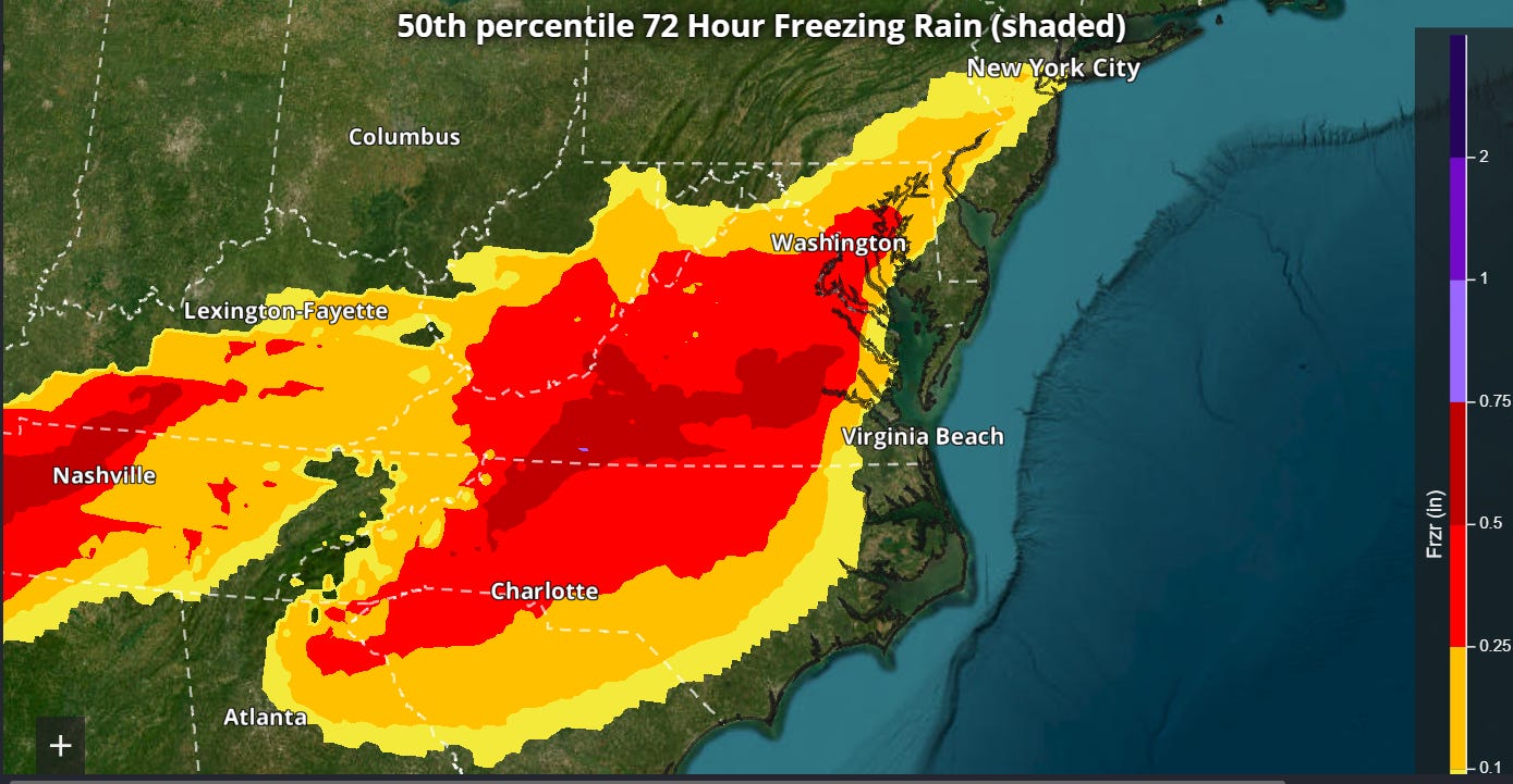
Overall, the shift in the model forecasts will mean a general shift in the highest anticipated accumulations of freezing rain/ice north into Virginia and parts of North Carolina, with potentially impactful glaze accumulations of .25” into the Washington, DC metro area. Areas farther south toward northeast Georgia and South Carolina have seen ice accumulation forecasts trend down as the trend of the stronger low to the west means warmer near surface temperatures, resulting in more rain and less freezing rain.
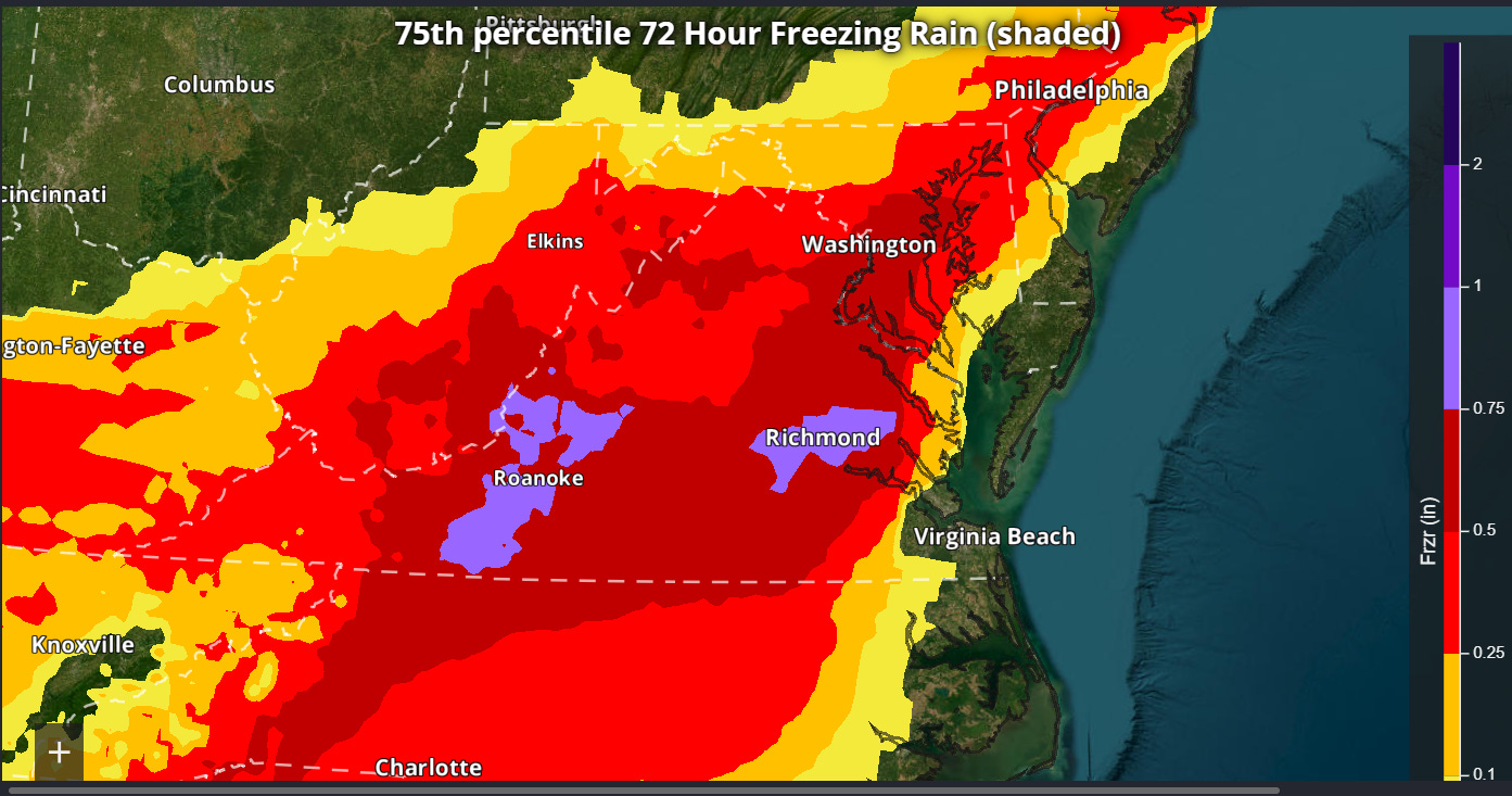
A reasonable worst case scenario (75th percentile probability) ice accumulation from the NWS National Blend of Models for the Mid-Atlantic suggests .5 to 1” ice accumulations are possible for much of Virginia, which could cause major damage to power infrastructure. Given the extremely cold temperatures expected after this event, this again would be of serious concern.
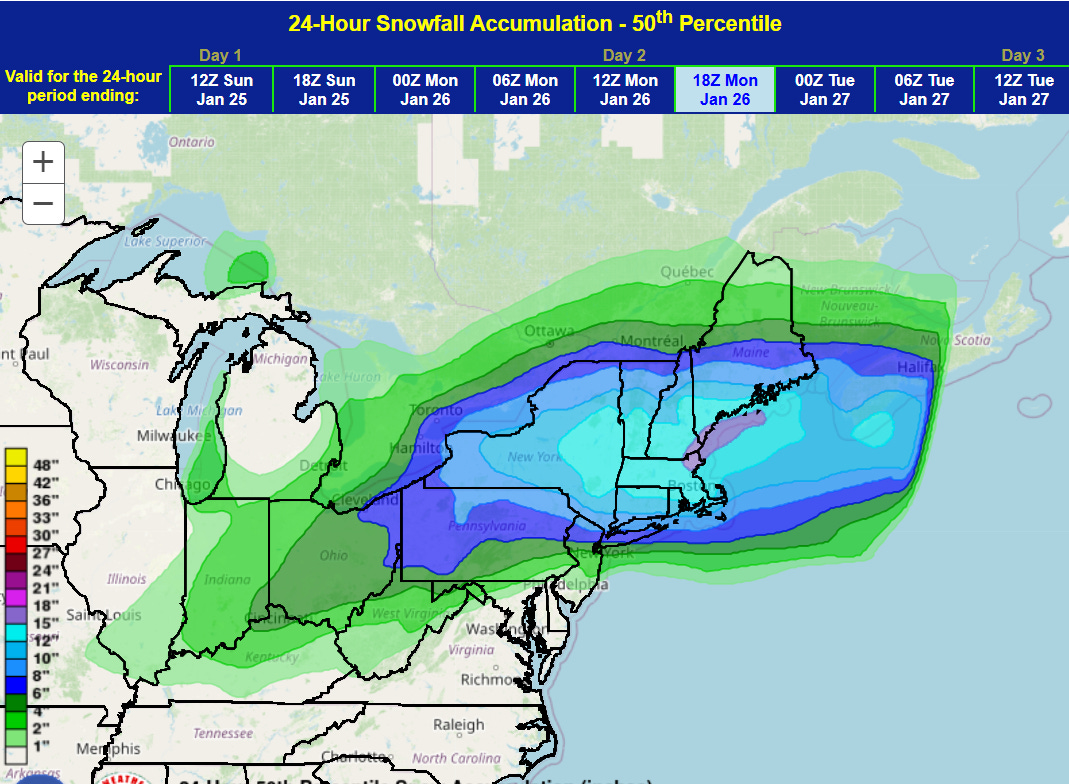
Very heavy snow is now expected across much of the Northeast, with 24 hour amounts ending at 1 pm Monday greater than a foot widespread across southern New England and the Hudson Valley. Areas farther south toward New York and Philadelphia will see much more sleet and freezing rain after an initial period of snow.
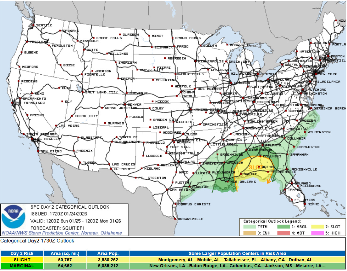
Last, but not least, the trend toward a stronger Gulf Coast low also means a greater risk for severe thunderstorms in the warm sector of the system. A slight (level 2 of 5) risk of severe storms is now in place for Sunday along the eastern Gulf Coast region, with damaging winds and tornadoes the primary risks.
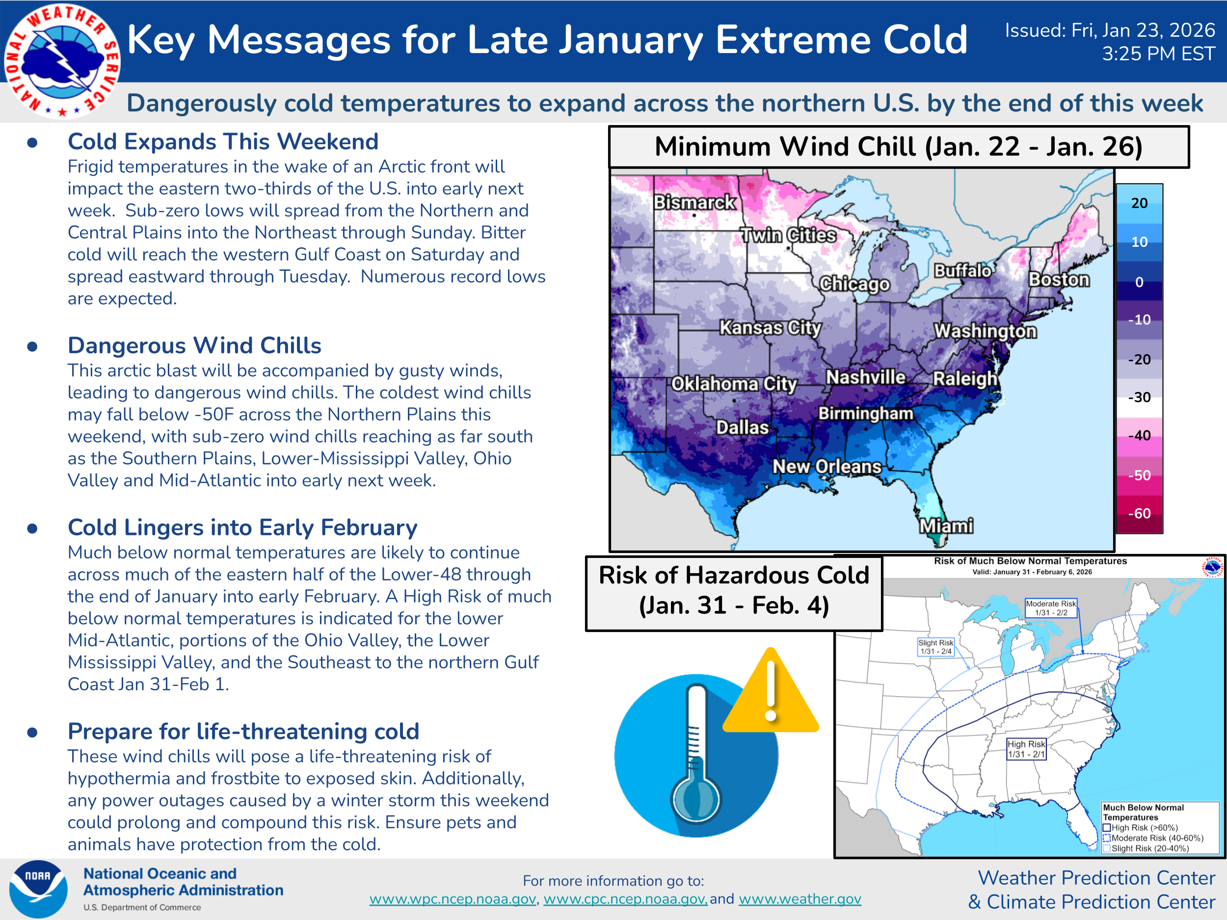
Of course, the extreme cold also continues to be a serious concern with waves of cold air continuing for the coming days — this WPC key messages graphic describes it well.
I will continue to provide updates via all the means (Substack notes, posts and chats; Bluesky and Facebook posts) through the weekend.

Leave a comment