New England bracing for upwards of 2′ of snow, while Mid-Atlantic anticipates additional ice and parts of Southeast US are under a tornado watch
Jan 25, 2026
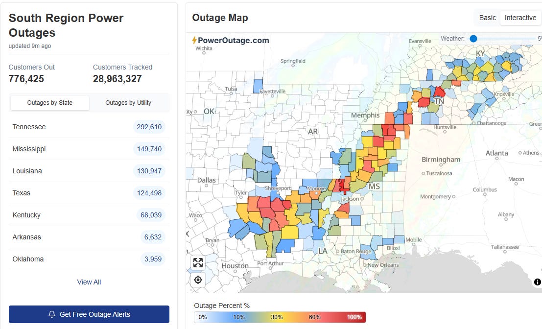
Good Sunday morning. The huge winter storm continues this morning, and overall (and unfortunately) the forecast seems to be working out relatively well. The advertised ice storm across the South is progressing about as expected, with numerous reports of .5 to 1” of ice accumulation in an axis from eastern Texas to Kentucky. The current power outage map above from PowerOutage.us clearly shows the footprint of this ice storm, with nearly 800,000 customers now without power in these areas due to extensive damage to trees and the power infrastructure. Keep in mind that most of the areas impacted by this ice are rural in nature so this is a pretty incredible number of outages, and as you can see many counties and parishes in the impacted area have more than half of their populace without power.
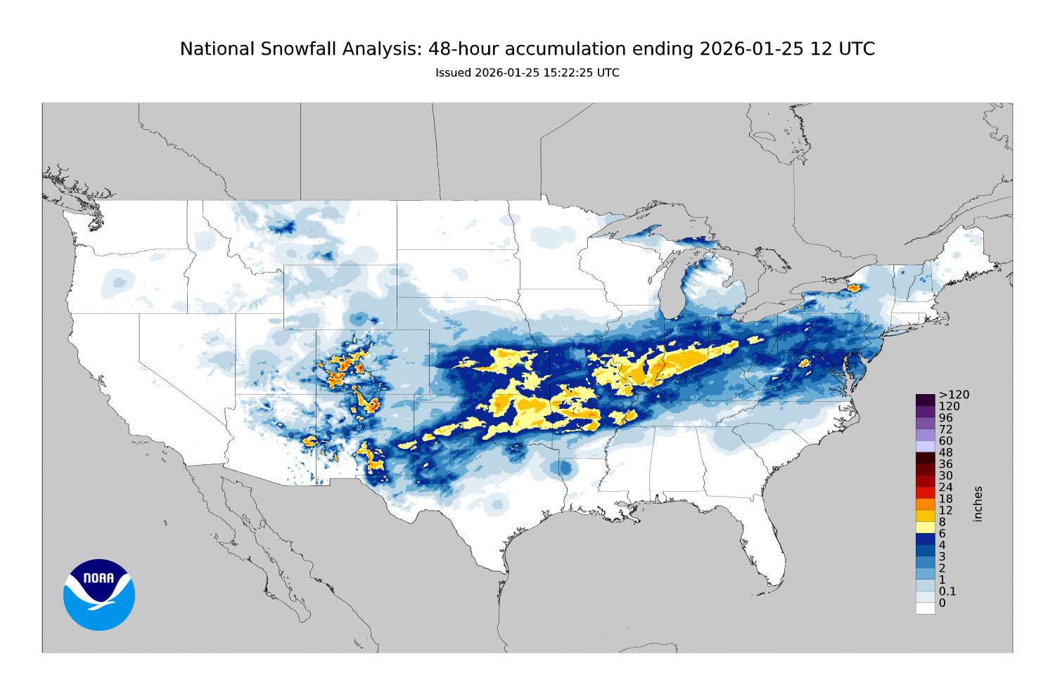
To the northwest, heavy snow has been the impact, with amounts of 6-12” common across Oklahoma, northern Arkansas and into the Mid-Mississippi and Ohio Valley regions. In the transition region between the heavy snow and ice, a band of very heavy accumulations of sleet occurred from northeast Texas across far northern Louisiana and southern Arkansas and parts of Northwest Mississippi. Sleet accumulations of 1 to as much as 5 inches of sleet were common in this area — which is truly incredible, as generally speaking it takes 1” of liquid precipitation to produce 2” of sleet.
While power outages have been less of an issue in the heavy snow and sleet impacted areas, obviously travel has been hugely impacted. As expected, the national airspace has been hugely snarled this weekend, with USAToday reporting that more than 10,000 flights have been canceled today and another 1,300+ experiencing delays.
The freezing rain and sleet has ended for the most part west of the Mississippi River, and will be winding down across Mississippi and Tennessee over the next several hours, and in Kentucky by this evening. Farther east, as you can see in the snowfall accumulation map above, the anticipated wave of heavy snow impacted the Mid-Atlantic overnight, but as expected warmer air has now surged north and changed much of the precipitation to sleet as far north as Philadelphia and Harrisburg per mPING crowdsource reports.
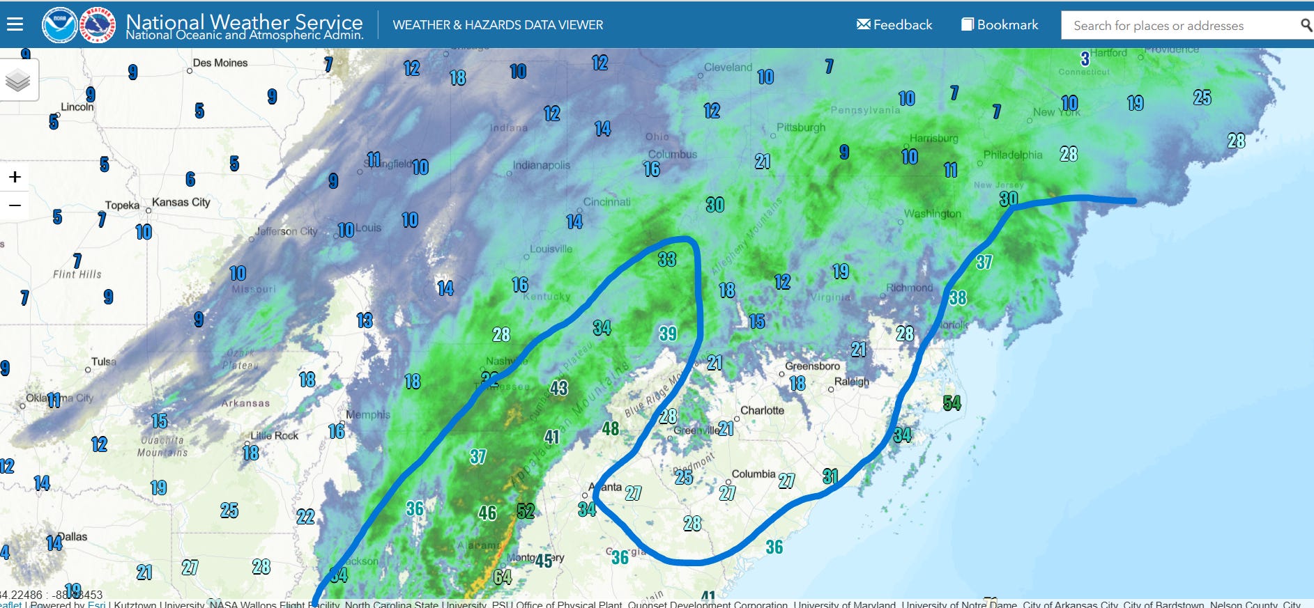
As you can see in the radar and temperature image above, temperatures remain below freezing in the “wedge” across the Carolinas, but precipitation has temporarily come to an end as a dry slot has surged into the region. This will change by late afternoon and evening as the precipitation back to the west moves into the area, bringing another period of significant freezing rain and sleet to the region that will last for several hours.
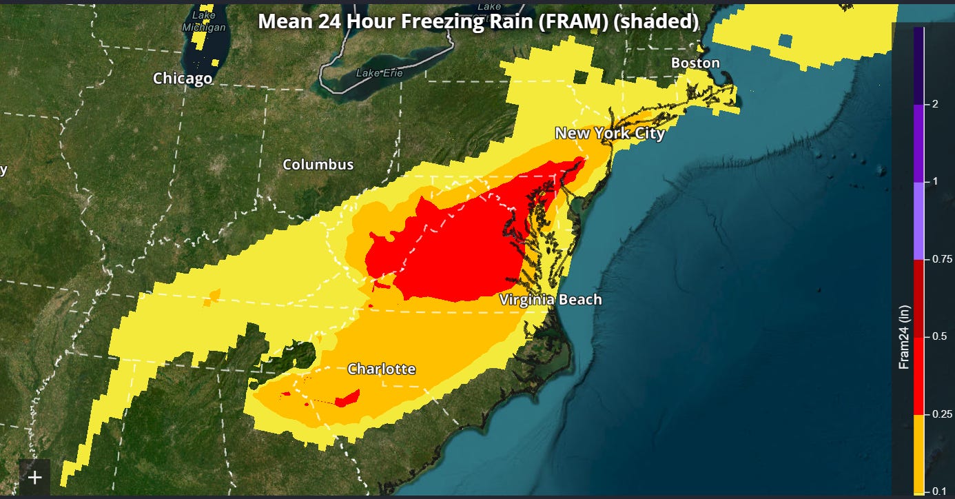
As even warmer air moves north across the Mid-Atlantic, sleet should mix with or change to freezing rain for a time as far north as New Jersey and potentially the NYC area as well, with the morning rapid refresh ensemble mean forecast of additional glaze accumulations through midday Monday shown above. Ice accumulation of this magnitude in this region could result in some significant power issues if it does in fact materialize.
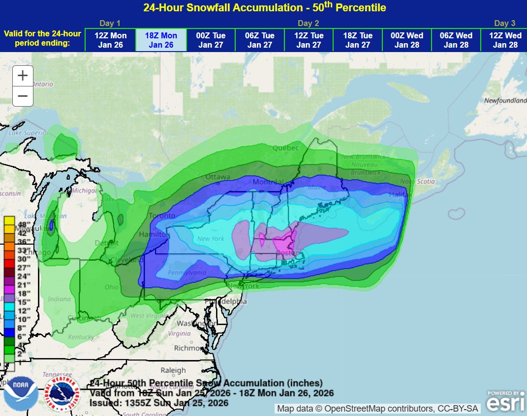
Meanwhile, north of the mix area, widespread very heavy snow is anticipated as shown in the NWS Weather Prediction Center of 24 hour additional snowfall ending at 1 pm ET Monday. Much of Massachusetts is now expecting 12-24” of snow with snowfall rates of 1-2” per hour for many hours, creating difficult to impossible travel conditions.
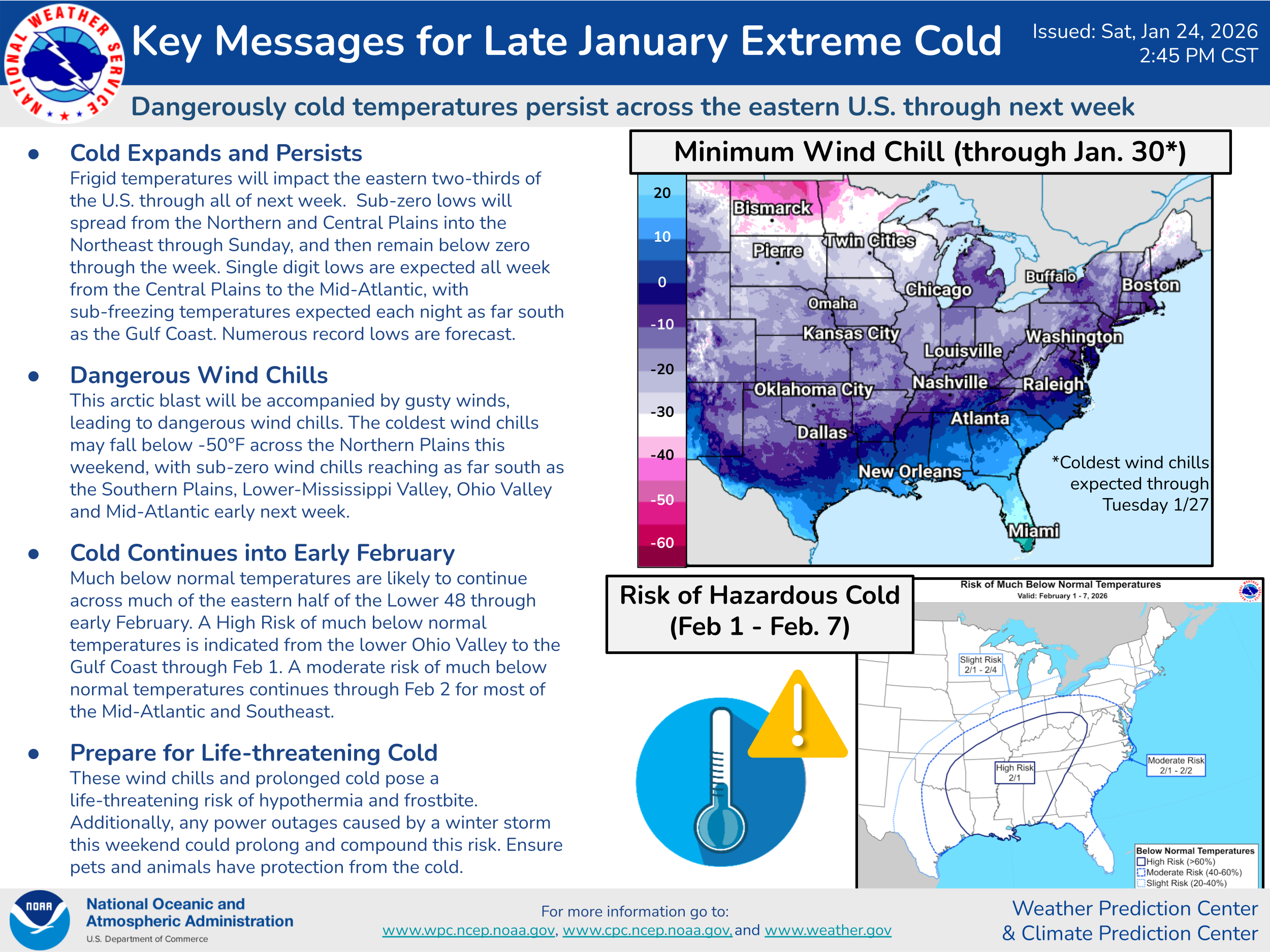
Of course, the extreme cold is another major hazard that will continue the next few days as discussed in the WPC Key Messages above. Many parts of the Deep South will see low temperatures in the teens and subfreezing temperatures into Tuesday. This could cause serious issues with pipes and water mains, especially in areas suffering extensive power loss. Hypothermia will also pose a serious risk across much of the country, and again especially in areas with extensive power outages. The Weather Channel just reported that 2 people died from hypothermia in the Shreveport, LA area overnight after being exposed to the conditions. Unseasonably cold conditions with additional waves of arctic air are expected across the East into early February.
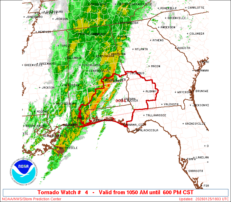
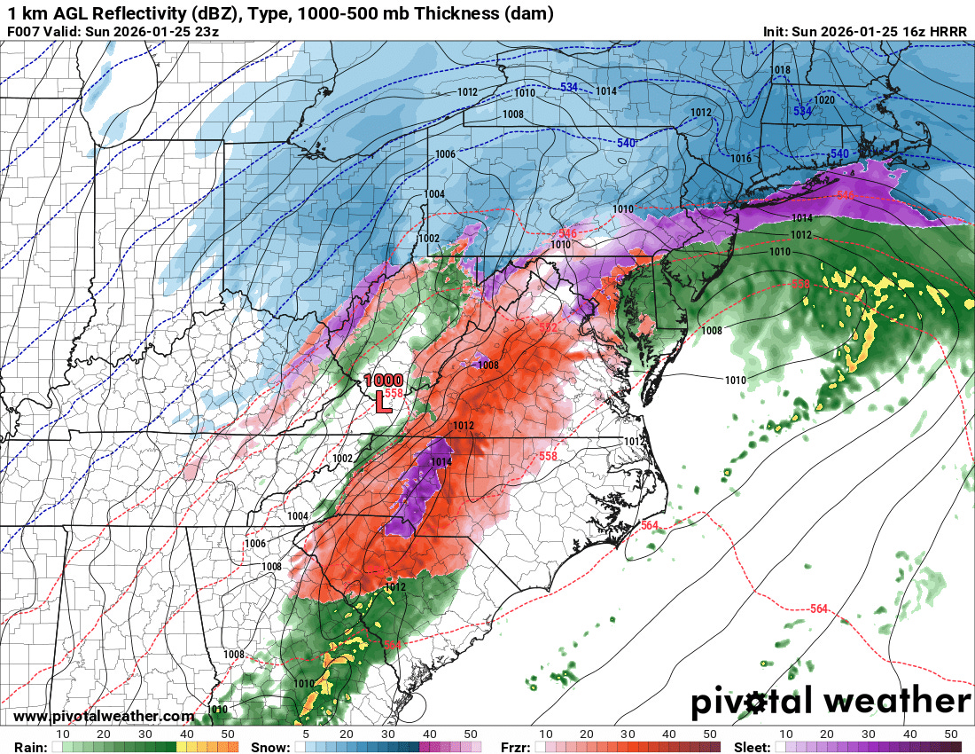
Finally, we need to discuss the severe weather threat this afternoon on the warm side of this system. The NWS Storm Prediction Center recently issued a tornado watch as shown above. A couple of band of strong to severe thunderstorms re currently moving across southern Alabama and the far western Florida Panhandle, with severe thunderstorm warnings for potentially damaging winds in effect in the area around Montgomery. As these storms continue to move east this afternoon, unusually high levels of Gulf moisture and warmth combined with strong wind shear will support additional severe thunderstorms, with damaging winds and tornadoes the primary threats.

The Nadocast AI severe weather system — which experience shows has rather good forecast skill — shows some risk for significant (EF2+) tornadoes this afternoon centered across southeast Alabama, and given the anticipated atmospheric conditions, this seems reasonable. Folks in this region should be monitoring the weather closely into this afternoon.
Again, I will be continuing to update via Substack notes and social media posts, and may do another Substack live chat this afternoon to update on winter and severe weather depending on how things evolve.

Leave a comment