Serious concerns for impacted areas as near record cold settles in. Meanwhile, a new storm lurks for the East Coast by this weekend.
Jan 26, 2026
The wintry precipitation from the widespread, high impact winter storm that impacted much of the eastern two-thirds of the country has finally wound down, so will start this morning with a recap of what happened.

The most impactful aspect was certainly the glaze ice accumulation from freezing rain that caused major impacts from Texas east-northeast into the Mid-Atlantic. My colleague Daniel Tripp, a University of Oklahoma researcher at the NOAA National Severe Storms Lab (NSSL), shared this graphic that shows the experimental ice accumulation product called FRANA from the NSSL Multi-radar Multi-sensor System. FRANA is the result of incredible work done by the research team at NSSL that focuses on severe weather impacts to transportation systems, resulting in some great winter weather focused R&D.
You can see very clearly the axis of the heaviest ice accumulations from northern Louisiana and Mississippi across Tennessee and Kentucky, with other areas of impactful ice accumulations in the central and southern Appalachians and Delmarva region. Daniel noted in his post that the research he and his team have done on ice accumulation to develop this product shows that ice accumulations greater than an inch are rare – but many areas from northeast Louisiana into middle Tennessee appear to have had amounts around or somewhat greater than an inch. The .9” measured accumulation by the NWS automated observing site at Monroe, LA is one of the highest glaze accumulations measured by one of those systems that I have personally seen.
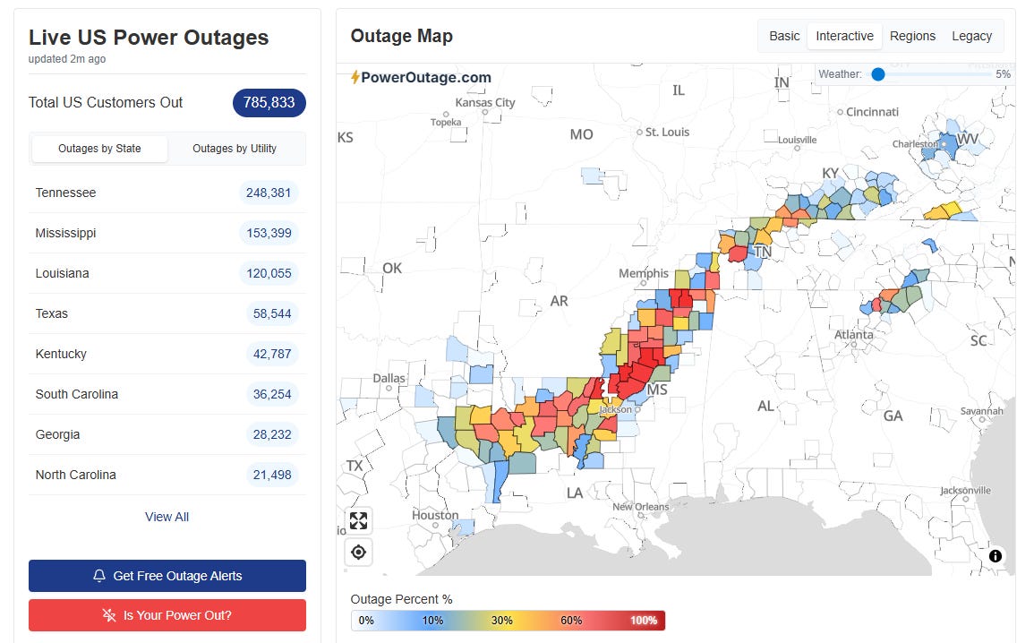
Needless to say, this ice accumulation had major serious impacts. Travel is and remains nearly impossible in many areas, and a bit more than 1,000,000 customers were without power at one point Sunday afternoon. At midday today, nearly 800K customers remain without power as shown in the map above from PowerOutage.us — and you can see very clearly how well the areas of power infrastructure impact line up with the heaviest ice accumulation on the FRANA graphic. While this ice storm was not as impactful (nor was it expected to be) as the historic 1994 ice storm that impacted many of these same areas and left more than 2,000,000 customers without power, it is likely the worst storm since that one and for some communities the tree and power infrastructure damage may rival (or even exceed) the 1994 event. This seems most likely for parts of the lower Mississippi Delta northeast across areas like Oxford and Grenada and into far south central Tennessee where more than an inch of glaze accumulation looks to have occurred.
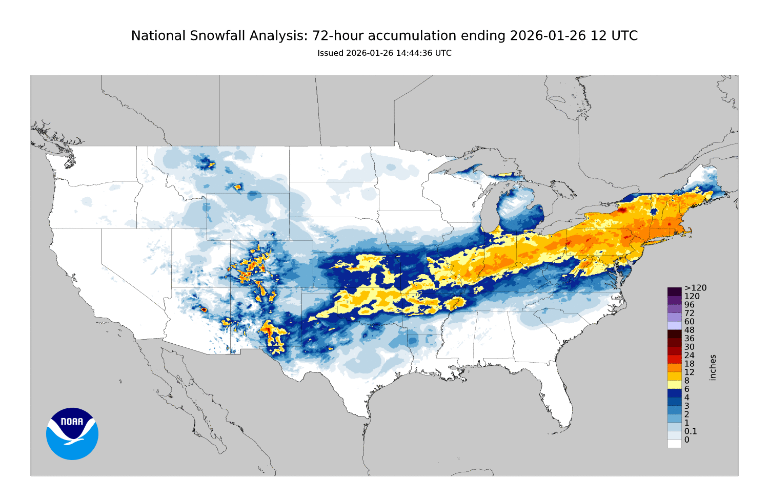
Farther north, very heavy snow was the main weather impact, with a huge swath of 6 or more inches of snowfall from Oklahoma northeast across nearly all of the Northeast from northern Virginia north. Localized amounts of 18-24” occurred over parts of Massachusetts, and to the lee of Lake Ontario where moisture from the lake enhanced snowfall. Areas of southern Ontario along the lake also had similar snowfall amounts. The heaviest snowfall report receive by the NWS so far has been 22.2” near Sterling, MA with a couple of locations in New York and New Hampshire also receiving 22”.
Between the heavy snow and heavy glaze ice accumulations, a band of heavy ice accumulations from sleet occurred. While sleet is not nearly as damaging to power infrastructure and trees as glaze, it still causes serious impacts especially to travel. The heaviest sleet fell over parts of Arkansas with numerous locations reporting more than 3” of accumulation — the NWS office at Little Rock airport had 6.7” and a location near Crossett, AR in the southeast part of the state reported 7”, one of the highest sleet accumulations I have ever seen. The NWS in Jackson reported this morning that the incredible weight of this heavy sleet was causing roofs to cave in around this area of southeast Arkansas — as of midday, 6 structures had suffered reported roof collapses.
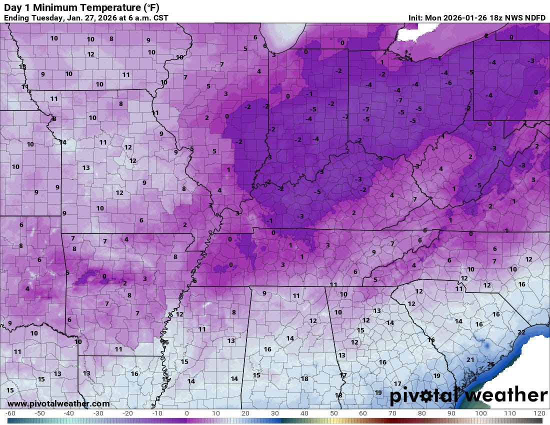
With the precipitation winding down today, the focus will turn to the bitterly cold temperatures expected tonight as shown above with a number of record lows anticipated. I am seriously concerned about the potential impacts of this unusual cold in areas where power remains out due to the ice storm. Homes in this part of the country are generally not insulated or built for this kind of cold weather, and if further compromised by the lack of power and heat, serious risks to life from hypothermia exist. CNN is reporting that 12 people are confirmed to have died due to the storm, and several of these appear to have been due to hypothermia. Another major risk is the potential for property damage due to burst, frozen water pipes.
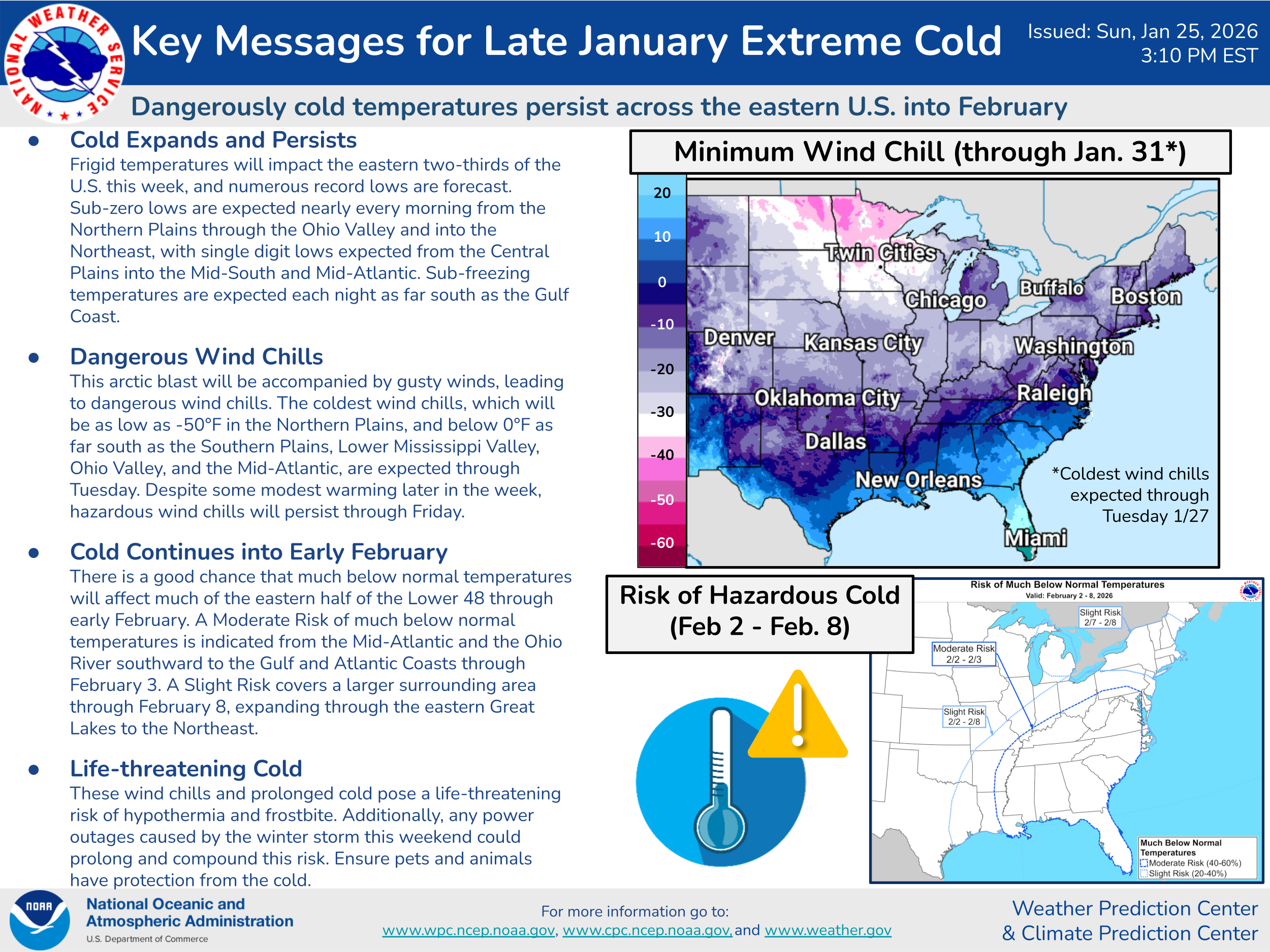
Unfortunately, the weather pattern that we have been talking about for the last 10 days or so (and for a fair amount of this winter) looks to continue for the foreseeable future — namely a large, unusually strong area of high pressure aloft along the West Coast with a corresponding downstream trough of low pressure in the East. This will keep temperatures generally below normal over the eastern half of the country, with periodic additional shots of bitterly cold Arctic air.
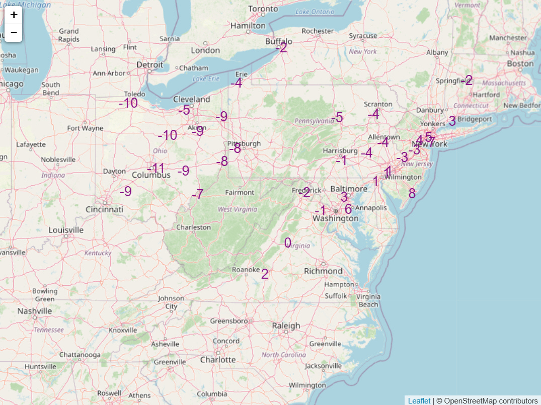
A new shot of Arctic air is expected late this week, with numerous record low temperatures expected across the Great Lakes and Northeast Friday (forecast records shown above courtesy NWS Weather Prediction Center) and Saturday.

The upper level weather disturbance that will bring this next shot of Arctic air will also spawn another storm system along the East Coast. As with this weekend’s storm, the models are struggling with this system and there is still quite a bit of uncertainty. However, the pattern is very favorable for an intense East Coast storm, and some model solutions are suggesting the potential of a high impact storm, particularly for areas from the Carolinas northeast along the coastal Delmarva and Northeast. We will be watching model guidance the next couple of days closely to see how strong and how close to the coast this storm ends up looking to be — as of now, the Winter Storm Severe Index (WSSI) probability graphic from WPC above does a good job of showing the areas most likely to be impacted in the Sunday time frame.
I will be traveling later today to the American Meteorological Society conference, so my posts may be a bit more irregular — but given the high impact weather ongoing, I will continue to try to post and make updates via social media. I also am hoping to share perspectives about the various issues affecting the federal and broader weather science community based on conversations with colleagues. More to come…

Leave a comment