Next blast of Arctic air on tap for this weekend, along with another winter storm that looks to focus on the Carolinas
Jan 28, 2026

I had the opportunity yesterday afternoon to join a distinguished group of my colleagues to speak in a panel about the US Public-Private Sector Weather Enterprise Partnership at the American Meteorological Society Annual Meeting. (I am in the middle, thanks to Kodi Berry for this pic — you can read more about the panel and the panelists here.) The United States has a rather unique weather enterprise compared to the rest of the world, in that the weather data generated by NOAA/National Weather Service is free of charge to everyone, and private sector companies can use that data to generate their own forecast information and products for commercial use.
That model has been very successful over the years, and a key part of that model has been that the public sector (i.e., the federal government) served as the primary entity responsible for producing observational and model data. In recent years, as technology and computing has evolved and become more affordable and as larger commercial entities such as Google, Amazon, and Apple have become more involved in weather, the private sector has been becoming a bigger player in the observational and model aspects of meteorology. Our panel yesterday talked about that evolution, which will likely cause rather significant changes in how weather forecasts are generated and disseminated in this country — and how to hopefully ensure that critical forecast information for impact weather remains equitable accessible to all in a new paradigm.
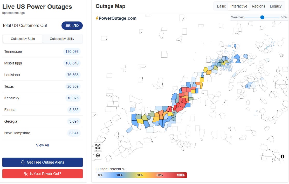
Speaking of impact weather, slow recovery continues from this past weekend’s winter storm. Power restoration continues, but nearly 400,000 customers still remain without power this morning, about 3 days after the end of the ice storm in the region. USAToday reports that more than 60 people have died from a variety of winter weather related incidents from this storm, including more than two dozen from hypothermia and exposure. Several children have died in tragic incidents involving them falling through ice on ponds — a particular issue when unusually cold air causes ponds and lakes to freeze in the South, where children (and adults) are not aware of how easily the ice can break and the rapidity with which someone can succumb to hypothermia in the freezing water.
House fires and carbon monoxide poisoning from efforts to keep homes warm are also huge risks in these Deep South arctic events, and have also been responsible for a number of tragic deaths. Additionally, a number of roof collapses have occurred, and 10 people were injured, some seriously, when a gas station canopy collapsed in Greenville, MS due to the weight of ice and meltwater on it.
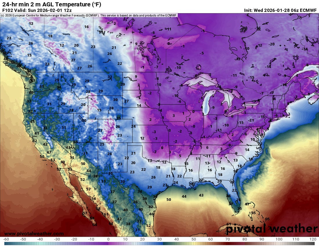
Unfortunately, as we have been discussing the next blast of Arctic air will be pushing into the eastern two-thirds of the country this weekend, with subzero low temperatures expected Sunday morning across much of the Midwest and Ohio Valley, single digits and teens well down into the South, and the potential for a significant, damaging hard freeze well south into Florida with lows in the lower to middle 20s forecast as far south as the Interstate 4 corridor.
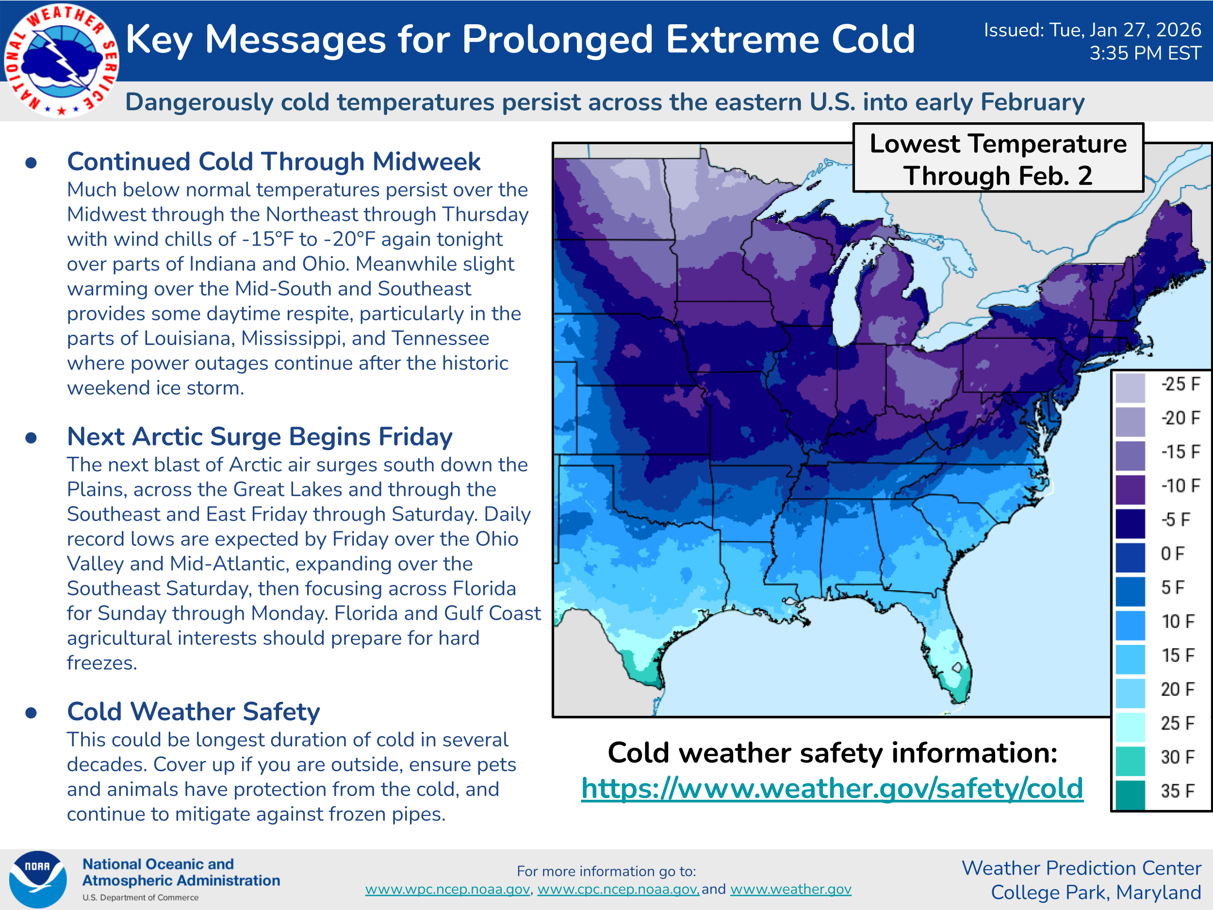
Overall, unusually cold weather is anticipated to last into early February, and given the trend toward milder winters in recent decades, this will likely be one of the most prolonged cold periods the East has seen in many years.
Meanwhile, the models are gradually coming into better agreement on the forecast for an unusually intense low pressure system that will develop along the East Coast this weekend in association with this next wave of Arctic air. The US global GFS model has been by far the most aggressive with potential impacts from this storm, showing a widespread, major blizzard for much of the Mid-Atlantic region — but in its last couple of runs has trended somewhat more muted. Meanwhile, the European suite of models has trended toward a snowier solution, particularly for portions of the Carolinas.
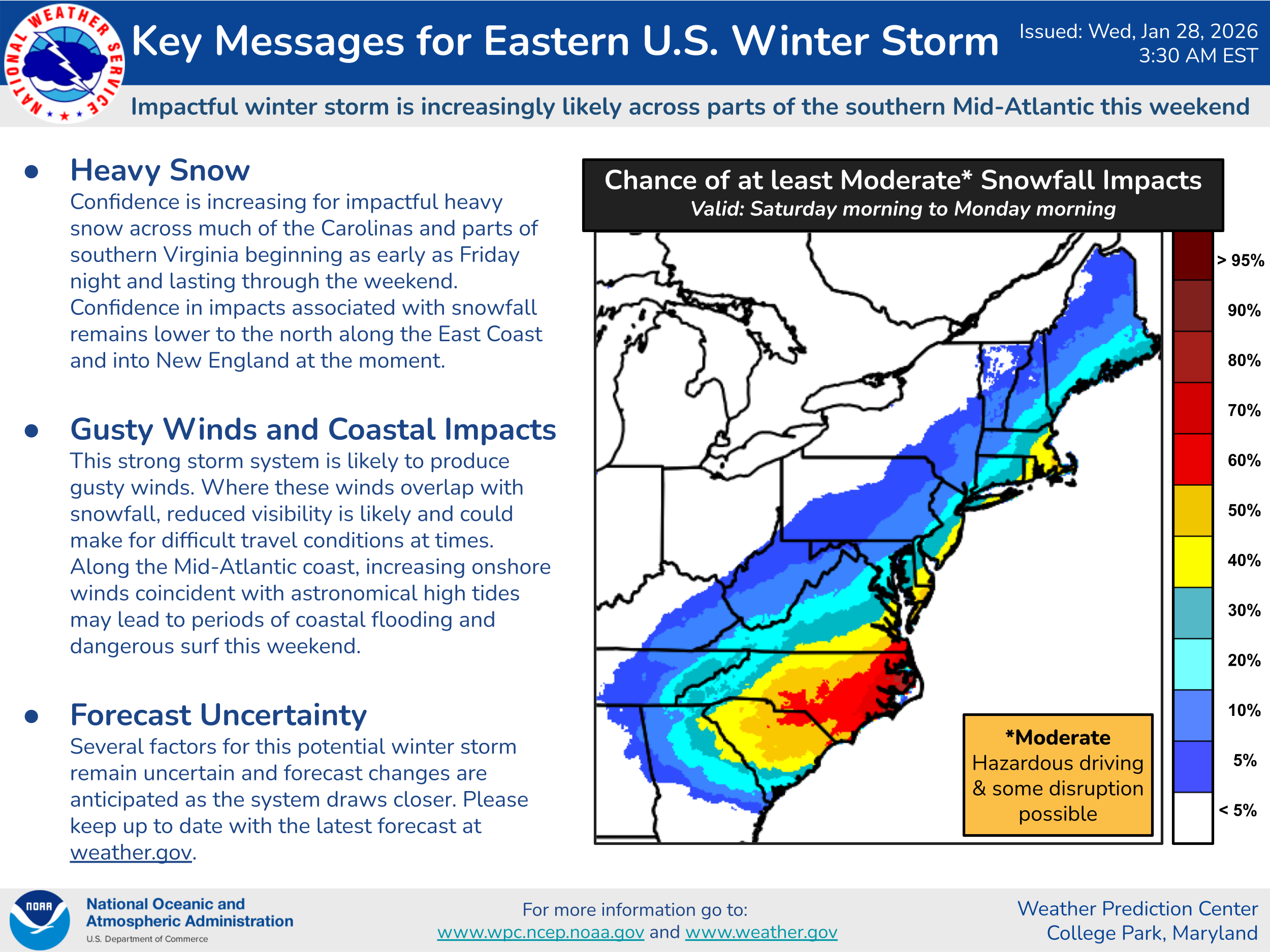
Overall, this Weather Prediction Center winter storm severity index probability of moderate impacts shows the areas most likely to receive heavy snow from this storm system as of now. High winds and coastal flooding are also anticipated as the system intensifies and pulls slowly northeast through the weekend — and depending on how close the system remains to the coast, it could also cause snow and wind impacts across parts of southern New England, particularly Cape Cod and the Islands. Obviously, given the anticipated intensity of this storm, we need to continue to watch it closely for any shifts to the northwest which could result in greater and more widespread impacts.

Leave a comment