A pattern change this week will at least bring some improvement in both regions
Feb 09, 2026
Welcome to a new work week. There has been a lot of deserved attention on the extreme winter weather of the last few weeks in the eastern United States that has left more than 100 people dead and billions of dollars in damage, along with some of the most prolonged bitterly cold weather in decades.

As I have discussed in previous posts, meteorologists tend to focus on what is happening at 500 millibars (~18K ft AGL) to understand the overall middle and upper level weather pattern controlling what we see as far as weather at the surface. If we look at the mean anomaly (difference from normal) of heights at 500 mb since the middle of January, we can see that the pattern has been dominated by unusually large and strong areas of higher heights (pressure) across much of the Arctic and along the western coast of North America. This has forced a large, persistent trough of low pressure across the eastern United States, with an even deeper and more anomalous trough across much of Europe.

If we look at the surface temperature anomaly for the same period, the unusual cold over the eastern half of the United States is evident, as well as colder than normal conditions over much of Europe. However, we can also see unusual warmth across much of the Arctic region as well as western North America.

While we had that period of extreme record warmth across much of the country around Christmas, if we look at the 500 mb pattern going all the way back to the start of December, we can see that the overall weather pattern of high pressure ridging over the western United States with a downstream trough along the East Coast and up into eastern Canada has been quite persistent for much of this winter.

Looking at the average surface temperature anomaly back to the start of December with that extreme warm period in late December included, the cold anomaly for the entire winter over the East is still visible but more muted. Meanwhile, the unusual warmth over the Arctic is very pronounced, and the warm anomaly over Western North American is stronger than the corresponding cold anomaly in the East.
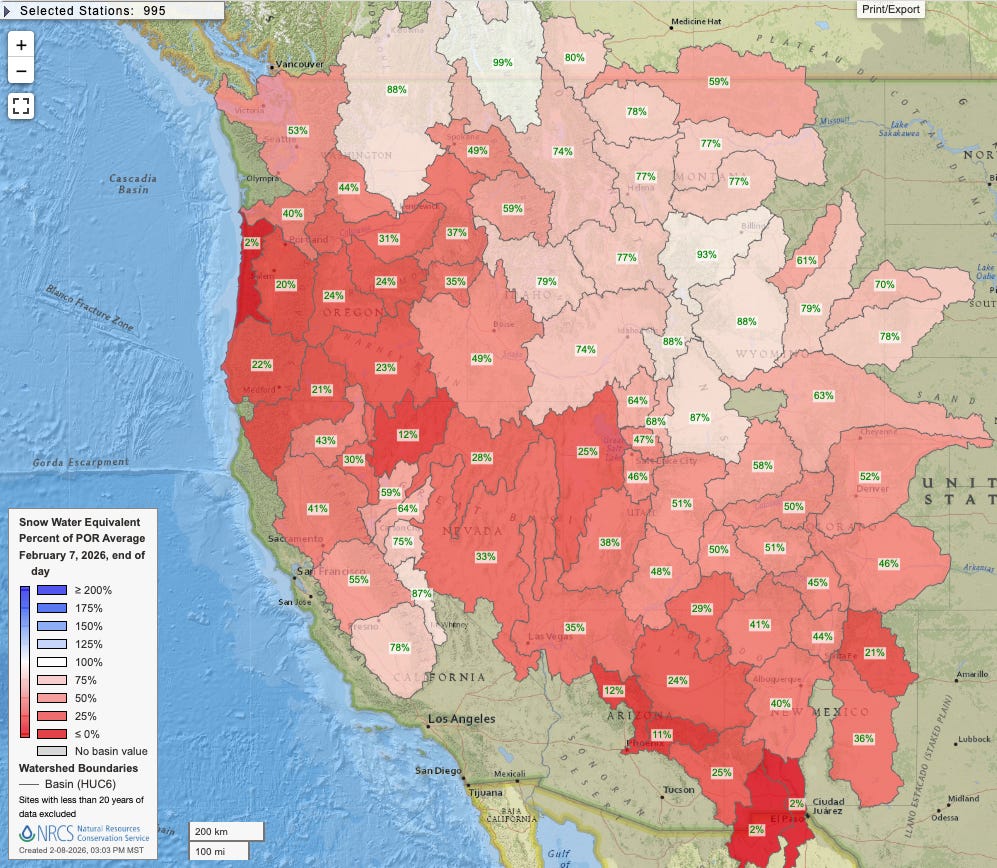
The unusual warmth in the West has led to an extremely poor snowfall season with below normal snow water equivalent across the entire region, and in many cases well below normal. This is in spite of a number of locations across the West actually having above normal precipitation — the unusual warmth has meant a much higher percentage of rain versus snow. Climate scientist Daniel Swain has an incredibly informative post on the state of the Western snowpack (TLDR very poor) here that I encourage you to read.
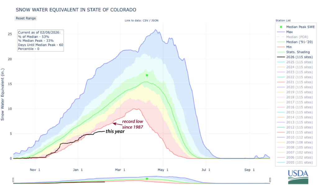
Colorado has had an exceptionally poor winter snow season, and state climatologist Russ Schumacher also put together a great post outlining how this is the worst year in decades, but likely not quite as bad a couple of seasons in the late 1970’s and early 1980s. Russ puts that into context:
However, obviously a lot of things have changed since the late 1970s! Nearly all ski areas now have robust snowmaking operations, which allow them to keep terrain open even when there’s not much snow falling from the sky. On the flip side, the population of Colorado has grown immensely—approximately twice as many people live in the state now as did in 1980. Which means that the demand for water (and for winter recreation) is much greater, and thus the potential impacts of a snow drought are much greater as well.
What has really set this water year apart thus far is how warm it’s been. For Colorado statewide, we just had the 3rd warmest November and the warmest December in over 130 years of records. January was very warm as well. Official numbers for January will be released this week (make sure you’re signed up to get our monthly summaries), but it clearly ranked among the top 20 warmest Januarys, and early February has continued the streak of warmth. The warmest start to a water year we’ve ever seen, combined with a lack of the snowstorms we typically see in winter, has brought us to the worst mid-winter mountain snowpack in decades.

Of course, we luckily still have a couple of months of winter snowfall season left to see things improve, and as I talked about yesterday, this week will see a transition toward a significantly changed weather pattern. By early next week, a strong trough of low pressure aloft will setup along the West Coast, which will bring colder and snowier weather to much of the West, particularly the Sierra Nevada. Meanwhile, the East will finally see a trend toward milder weather.

While obviously this is a positive sign for the Western snowpack that should bring more “normal” levels of snowfall, as both Daniel and Russ note in their posts, right now outside of maybe the Sierra this does not look like a setup for particularly heavy snow that could enable snowfall to significantly “catch up” to normal. Also, looking at the European ensemble 500 mb forecast for late next week, the forecast becomes more unclear with a less defined trough along the West Coast, leading to uncertainty as to how long this pattern shift will persist.

In the next few days, snowfall will be increasing in higher elevations of the Sierra as shown in the Weather Prediction Center’s Winter Storm Severe Index (WSSI) forecast for the next 3 days. Some light to moderate wintry precipitation will cause some minor impacts in the upper Great Lakes and Northeast.

In the central and southern Plains, record warmth combined with gusty south to southwest winds and dry conditions will lead to critical wildfire danger this afternoon and evening.

Leave a comment