Monitoring a low confidence forecast along the East Coast in about a week, with some models showing a higher impact storm for the Northeast
Feb 10, 2026
In my post yesterday, while talking about the persistent upper level weather pattern in the Northern Hemisphere I noted that along with the trough along the East Coast there was also an anomalous trough centered near Europe. One of my readers on BlueSky noted that the UK is dealing with record rainfall as part of this pattern, and I decided to start off this morning with a bit of a dive into the impacts of another region dealing with this seemingly stuck Northern Hemispheric weather pattern, i.e., western Europe.

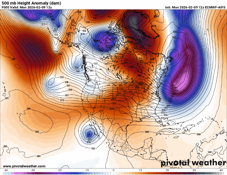
The 500 millibar (mb, ~18,000 ft AGL) anomaly since the start of 2026 is literally “off the charts” with a nearly 200m anomaly centered just southwest of Britain.

The actual mean 500 mb height pattern for that period, i.e., the pressure pattern that shows meteorologists what the atmospheric flow is like at jet stream level, shows a deep trough over the North Atlantic with a strong area of high pressure west of north Africa. The result of this is a strong westerly jet stream directed into western Europe.

Indeed, if we look at the anomaly in the strength of the zonal (west to east) wind across the region since the start of January, we see much stronger than normal westerly winds from the Azores into the Iberian Peninsula. The primary result of this persistent weather pattern has been a parade of strong storm systems into western Europe.

This has resulted in much above normal precipitation across much of western Europe, particularly across the western Iberian Peninsula where the abnormally strong jet stream was focused as seen in the zonal wind anomaly above. As intense upper level disturbances have moved through the North Atlantic trough, the strong jet stream has brought focused atmospheric rivers into this region, creating tremendous amounts of rain.
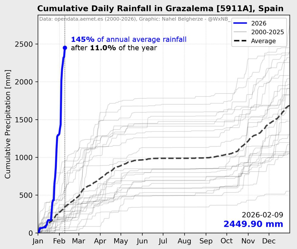
Nahel Belgherze posted this incredible graphic on BlueSky last night showing that Grazalema, Spain has picked up nearly 2500 mm (2449.9 mm = 96.5”) of rain since the start of 2026. As he notes, this is 145% of its normal annual rainfall total — and it has picked that up in the first 5+ weeks of the month. Not surprisingly, this rainfall has produced serious flooding in Spain and Portugal, with more than 11,000 people forced from their homes in Andalusia and serious damage and impacts to transportation and agriculture across the region.
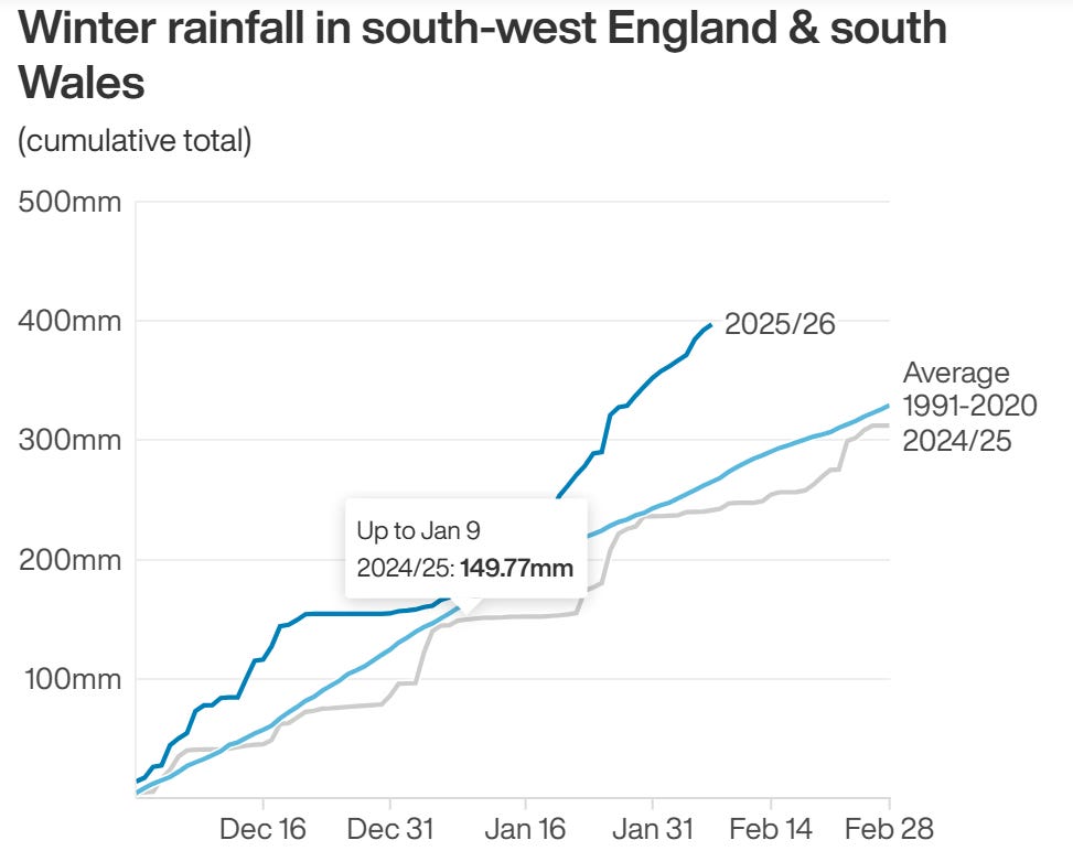
As noted at the start of this newsletter, the UK has also been dealing with record rainfall and flooding. From Yahoo News:
The Environment Agency (EA) warned flooding was expected in 99 areas, mostly across the south of England, around the southern Welsh border and in the East Midlands – and was possible in a further 170 areas. At least 300 properties have been flooded so far, the EA estimates.
It comes after a record-breaking month of rain, which became the wettest January on record for Cornwall, and County Down in Northern Ireland, according to the Met Office. The forecaster said many have been left with a sense that winter has been “stuck on repeat”, with 26 of its weather stations setting new records for January rainfall. The UK has already seen 89% of the average rainfall expected for meteorological winter (December, January and February) – while England has exceeded it by 11%, it said. Parts of Devon, Cornwall, Worcestershire, Somerset and West Sussex have recorded more than 30 consecutive days of rain, while North Wyke in Devon, Cardinham in Cornwall, and Astwood Bank in Worcestershire have seen it rain every day of the year so far.
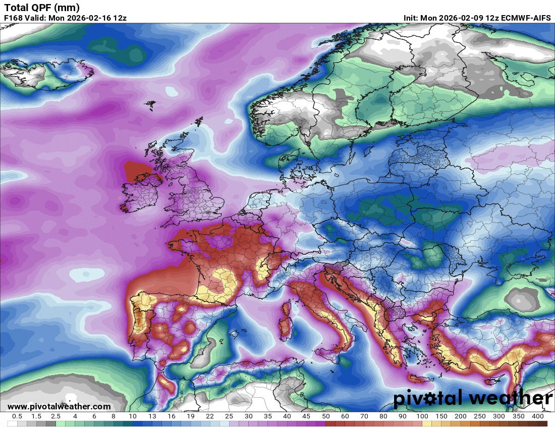
This general weather pattern is expected to continue for the next week, with a series of storm systems bringing heavy precipitation to much of Europe, with particularly heavy amounts expected in the higher elevations of southern Europe. This will of course likely bring additional flooding concerns.
Coming back to North America, this 7-day animation of the 500 mb forecast from this morning’s hot off the press European AI model shows the long advertised evolution of the weather pattern expected across the US this week. A series of storm systems will gradually break down the large area of high pressure aloft in the West, climaxing in an intense system approaching the West Coast Sunday into Monday. Meanwhile, a ridge of high pressure aloft will gradually build east from the central United States toward the East Coast, resulting in a trend toward milder weather east of the Rockies.
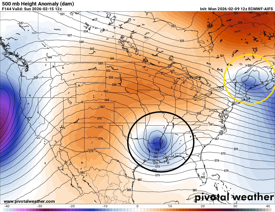
The potential flies in the ointment for the East are these two upper level disturbances I have circled above. The yellow one is a southeast moving disturbance that is kind of the last gasp of the polar trough of low pressure that has been plaguing the east for weeks, while the black circled one is the first piece of the new West Coast trough which will be undercutting the high pressure area over the central United States. Most of the models keep these two systems separate from each other — with the end results as far as sensible weather being a shot of snow and colder weather for the Northeast from that system and a swath of (needed) precipitation in the form of mainly rain for the Southeast quarter of the country.
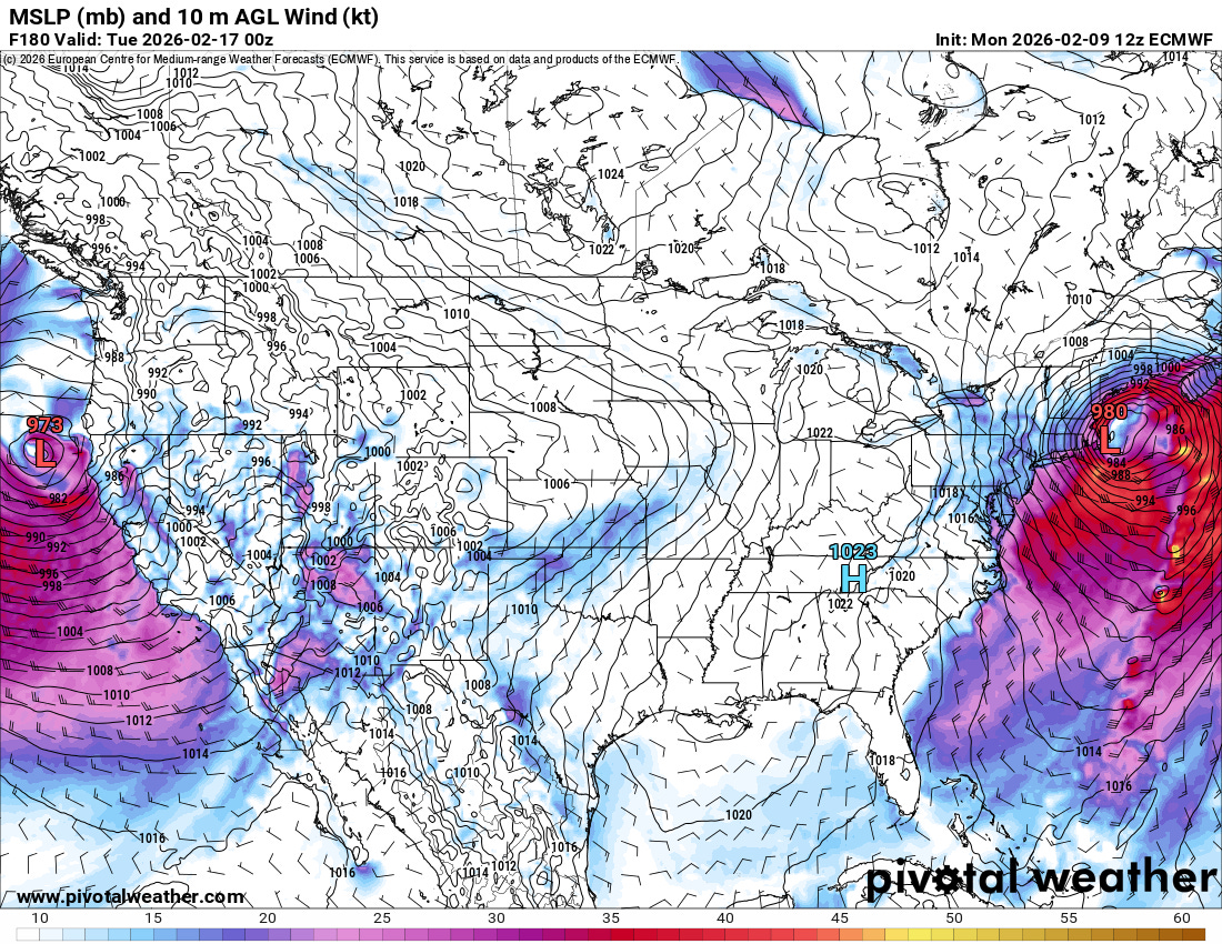
The operational European model (surface forecast for next Monday evening above), however, continues to insist that the northern and southern streams of energy will “phase” by early next week, resulting in an intense storm system that could bring significant impacts to the Northeast. Right now, this solution does not have much model support and I would consider it a lower probability outcome. However, given the normal reliability of the operational European model and the fact that some ensemble members do show a stronger, more phased system (and of course that it still a week away) means we should continue to monitor how this setup will evolve.
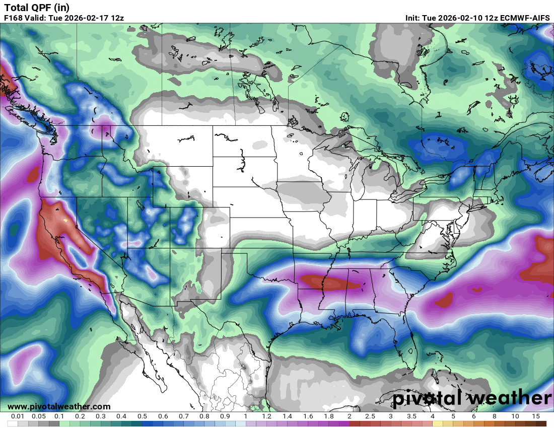
Regardless of how that uncertainty in the forecast plays out, the next 7 days should bring beneficial precipitation to much of the West and south central and southeast parts of the country. The precipitation will be gradually ramping up across the West the next several days. While there will be some showers Wednesday into Thursday across the Southeast, the bulk of the heavier precipitation in this region will be later this weekend into early next week.
Note: composite graphics used in both today and yesterday’s analysis of the Northern Hemispheric weather pattern from the excellent website maintained by NOAA’s Physical Sciences Laboratory.

Leave a comment